Odaigahara (Route 309) Guide: Pacing, Life-Saving Gearing, and Remote Mountain Supplies for the 9.9 km Forest Road That Starts Gentle and Turns Steep
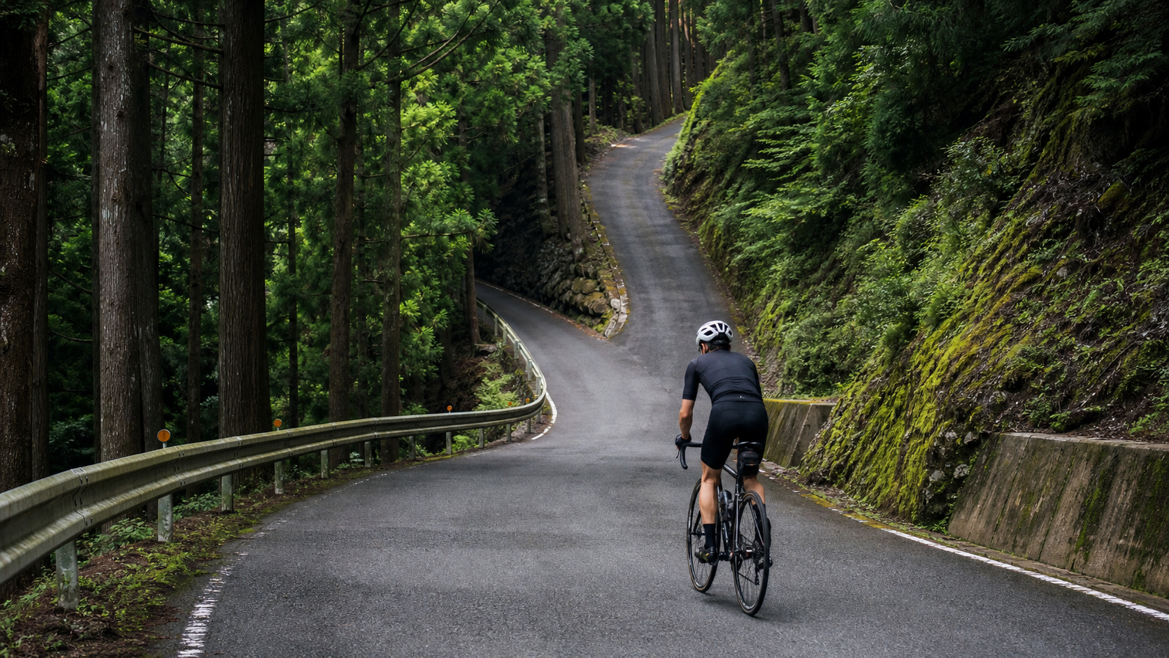
Deep in the mountains of Nara Prefecture lies a road that climbers in the Kansai region both revere and fear—Route 309 leading to Mt. Ōdaigahara. This is the stage for Japan’s renowned “HILLCLIMB ŌDAIGAHARA (Mt. Ōdaigahara Hill Climb),” held annually since 2001 and one of western Japan’s most prestigious climbing events, famous for its “extreme elevation gain and narrow, steep forest roads.”
The Strava segment featured in this article has the following stats: 9.9 km (9,906 meters), 572 meters of total elevation gain, and an average gradient of 5.8%. This is a core section within the long climb to Mt. Ōdaigahara (the full course is longer and climbs more). A 5.8% average gradient may seem moderate, but you need to understand the context: what makes this road truly formidable is its “polarized” character—gentle at the start, then a continuous steep ascent through narrow forest roads in the latter half—along with its remote, deep-mountain setting.
To draw a Taiwanese analogy, its difficulty and atmosphere are close to “an industrial road that cuts deep into the Central Mountain Range, narrow and sparsely populated, with the gradient turning vicious in the latter half.” This is not a leisurely sightseeing climb; it is a deep-mountain trial of endurance, pacing, and willpower.
1. Reading the Data: The “Polarized Character” Behind a 5.8% Average Gradient
| Item | Data | Interpretation |
|---|---|---|
| Distance | 9.9 km | Medium-long distance |
| Total Elevation Gain | 572 m | Equivalent to climbing 187 floors continuously |
| Average Gradient | 5.8% | Moderate, but unevenly distributed |
| Route Character | Gentle start, steep finish, narrow forest roads | Difficulty concentrated in the latter half |
| Category | Category 3 | Environment and steep sections add to the difficulty |
The key to the 5.8% average gradient: The full Mt. Ōdaigahara course is known for its “polarized” nature—the early section along settlements and river valleys is relatively gentle, but after a certain point, it turns onto narrow forest roads where the gradient climbs continuously (the hardest core forest-road section of the course can average over 10%). Although this segment presents a 5.8% average, you must save your strength for the narrow, steep ascent in the latter half—this is the biggest pacing challenge on this road.
Key Concept: The difficulty of Mt. Ōdaigahara lies not in the average, but in the “distribution.” Save the ambition of the early section—the narrow forest roads in the latter half are the real battlefield.
2. Section-by-Section Strategy: Breaking the 9.9 km into Three Parts
Section 1 (0–4 km): River Valley Settlements, 3–5% Gradient
The early section follows settlements and a beautiful river valley, with a relatively gentle gradient.
- Pacing: This is the easiest place on the entire route to misjudge. The gentle slope tempts you to speed up, but you must hold back—you will need every ounce of strength for the latter half.
- Cadence: Maintain 85–90 rpm, cruising comfortably.
- Resupply: The roadside station (michi-no-eki) and convenience stores near the start are your last resupply points. Be sure to top up on water and energy.
Section 2 (4–7 km): Entering the Forest Road, Gradient Steepens to 7–10%+
Past the settlement area, the road turns onto narrow forest roads where the gradient climbs continuously. This is the true core and crux of the entire route.
- Response: Immediately shift your mindset—from “cruising” to “grinding.” Downshift to protect your cadence, steadily raise your output, but don’t blow up all at once.
- Narrow Conditions: The forest road is narrow. Watch for oncoming traffic, falling rocks, fallen leaves, and slippery surfaces. Safety comes first.
- Mental Battle: Here you can’t see the finish, and the scenery is relatively enclosed—this tests your willpower the most. Break the route into small chunks and conquer them one by one.
Section 3 (7–9.9 km): Continuing the Forest Road Climb, Gradient Stays Steep
The latter half continues climbing on narrow forest roads, with the gradient remaining fairly steep (toward the full course, it connects to the relatively easier Mt. Ōdaigahara Driveway).
- Finishing: This is pure willpower. Keep your eyes close, and push forward corner by corner.
- Reminder: The higher you climb into the deep mountains, the lower the temperature and the more changeable the weather. Keep an eye on your body temperature and the conditions.
3. Gearing and Equipment: Bring Enough “Life-Saving Gears” for This Road
With the continuous steep climbs on narrow forest roads in the latter half, you can’t be stingy with your gearing.
| Rider Level | Chainring | Cassette | Notes |
|---|---|---|---|
| Advanced / Racing | 50/34 | 11-32 | Minimum 32T for the steep forest roads in the latter half |
| General Enthusiast | 50/34 | 11-34 | Most recommended; life-saving gear for the latter half |
| Beginner / Conservative | 46/30 or GRX | 11-36 | Strongly recommended for those who want to finish and protect their knees |
Equipment Essentials:
- Wheels: For a medium-long climb, lightweight or all-round rims work well; the deep-mountain road surface is poor, so don’t inflate tire pressure too high—prioritize grip.
- Warmth: Temperatures are low at high elevations in the deep mountains, and weather changes quickly. Be sure to bring a windproof, insulating layer.
- Descent: Descending on narrow forest roads carries high risk (fallen leaves, slippery surfaces, poor visibility). Check your brakes thoroughly and control your speed at all times.
- Carrying Supplies: There are no resupply points in the mountains. Carry enough water and energy on the bike.
4. Resupply and Hydration Strategy
- Water: The roadside station Michi-no-Eki Yoshino Rojō Kitayama near the start and convenience stores are your last resupply points. After that, there are no resupply points in the deep mountains, so fill up completely.
- Energy: Consume carbohydrates on a regular schedule. In particular, take a dose before entering the steep forest-road section so it takes effect when you need it most.
- Life-Saving Principle: This is a remote deep-mountain route—better to carry too much than too little. Your phone, supplies, and warm layers are all indispensable.
5. Weather and Seasonal Considerations
- Spring/Summer (April–September): In the deep mountains of Nara, summer is relatively cool, making it a popular summer climbing destination. However, afternoon fog and thunderstorms are common in mountainous areas, and deep-mountain weather is highly changeable.
- Autumn (October–November): Foliage season. The autumn colors around Mt. Ōdaigahara are stunning, making it the most popular season of the year. Mt. Ōdaigahara is also a well-known stargazing spot.
- Winter (mid-November–April): The Mt. Ōdaigahara Driveway is typically closed in winter. The deep mountains are bitterly cold with snow and ice. Do not attempt to go under any circumstances. Always confirm road access before departing.
- General: Mt. Ōdaigahara is one of Japan’s rainiest areas. The weather can change in an instant. Be sure to check the forecast, and bring rain gear and warm layers.
6. Common Mistakes and DNF Risks
- Losing control of pacing in the early section: Fooled by the gentle river-valley slope, you hit the steep forest-road section only to find your legs are gone.—Solution: Strictly hold back for the first 4 km.
- Gearing too heavy: Bringing only an 11-28 onto the narrow, steep forest roads means you can’t turn the pedals and are forced to dismount or even roll backward.—Solution: At least 34T; 36T for the conservative.
- Running out of supplies: Assuming a medium distance doesn’t require much, you bonk and dehydrate with no resupply in the deep mountains.—Solution: Fill up at the start and carry enough on the bike.
- Ignoring road closures: Venturing up in winter or in bad weather.—Solution: Always check road access and weather before departing.
- Riding too fast on narrow forest-road descents: Fallen leaves, slippery surfaces, and poor visibility cause you to lose control in corners.—Solution: Control your speed at all times; safety first.
7. Target Time References for Different Rider Levels
The following are reference finish times for this segment of approximately 9.9 km with 572 meters of climbing (for this segment only; the full course is longer):
| Rider Level | Reference Time | Average Speed | Intensity Concept |
|---|---|---|---|
| Racing | 30–36 min | Approx. 16–20 km/h | Steady rhythm, on the higher side |
| Advanced | 37–46 min | Approx. 13–16 km/h | Steady aerobic, on the higher side |
| General Enthusiast | 47–58 min | Approx. 10–13 km/h | Steady aerobic |
| Beginner Finisher | 59–75 min | Approx. 8–10 km/h | Goal is a steady finish |
A word to challengers: Mt. Ōdaigahara is not an easy road. It will deceive you with its gentle start, test you with its narrow, steep forest roads in the latter half, and remind you to stay humble with its remote deep-mountain setting. Keep your pacing in check, bring enough gearing, and stock up on supplies—when you emerge from that narrow, steep forest road, you’ll understand why this road has sustained a climbing event for over two decades.
Route data: 9.9 km distance, 572 meters total elevation gain, 5.8% average gradient (Strava segment; a core section of the long climb to Mt. Ōdaigahara), Kamikitayama Village, Nara Prefecture, Route 309, stage of a renowned western-Japan climbing event, remote deep-mountain climb.
8. “HILLCLIMB ŌDAIGAHARA”: A Battle That Has Endured for Over Two Decades
To understand the weight of the road to Mt. Ōdaigahara, you need to know the event behind it—the “HILLCLIMB ŌDAIGAHARA (Mt. Ōdaigahara Hill Climb).”
Held annually since 2001 in Kamikitayama Village, Nara Prefecture, this event is regarded as one of western Japan’s most prestigious climbing races. Its full course is famous for its “extreme elevation gain and narrow, steep forest roads”—climbing from the village start all the way to Mt. Ōdaigahara, the elevation difference is staggering, and the hardest core is that stretch of narrow forest road with gradients continuously exceeding 10%. For over two decades, this course has tormented and forged countless climbers, and it is considered the “graduation exam” for many hardcore Kansai riders.
The Strava segment featured in this article (9.9 km, 572 meters of climbing, 5.8% average gradient) is a core section within the long climb to Mt. Ōdaigahara. The full course is longer, climbs more, and is even more grueling. But even this core section, with its “gentle start, steep finish, narrow forest roads” polarized character, is enough to make you appreciate the difficulty of this legendary course. Understanding the context of this event will help you maintain the proper respect for this road—it is not a leisurely sightseeing climb, but a deep-mountain battle that demands serious preparation.
9. Real-World Scenario Simulation: A Complete Mt. Ōdaigahara Challenge
Before Departure: This is a remote deep-mountain route, so prepare with “survival” as the principle. At the roadside station Michi-no-Eki Yoshino Rojō Kitayama near the start and convenience stores, fill up on water and have a carbohydrate meal—these are your last resupply points. Confirm you have a 34T cassette (36T for the conservative), have your windproof insulating jacket ready, and check road access and weather (Mt. Ōdaigahara is rainy; closed in winter).
Section 1 (0–4 km): Ride along settlements and the river valley, gradient 3–5%. This is the easiest place on the entire route to misjudge—the gentle slope tempts you to speed up, but you must hold back; you will need every ounce of strength for the latter half. Maintain 85–90 rpm, cruising comfortably.
Section 2 (4–7 km): Enter the narrow forest road, gradient steepens to 7–10%+. Immediately shift your mindset—from “cruising” to “grinding.” Downshift to protect your cadence, steadily raise your output, but don’t blow up all at once. Watch for narrow conditions, oncoming traffic, falling rocks, and slippery surfaces. Here you can’t see the finish and the scenery is enclosed—this tests your willpower the most. Break the route into small chunks and conquer them one by one.
Section 3 (7–9.9 km): Continue climbing on the forest road, gradient stays fairly steep. This is pure willpower—keep your eyes close and push forward corner by corner. The higher you climb into the deep mountains, the lower the temperature and the more changeable the weather. Keep an eye on your body temperature and the conditions.
After Reaching the Summit: Immediately put on your windproof insulating jacket. Weather at high elevations in the deep mountains is changeable—don’t linger. When preparing to descend, be extra cautious—the narrow forest-road descent (fallen leaves, slippery surfaces, poor visibility) is the highest-risk part of the entire route. Control your speed at all times.
10. Gearing and Equipment: Bring Enough “Life-Saving Gears” for This Road
With the continuous steep climbs on narrow forest roads in the latter half of Mt. Ōdaigahara, you can’t be stingy with your gearing—this is the key to whether you can finish, and even whether you can dismount safely.
Gearing: Advanced/racing riders need at least 32T for the steep forest roads in the latter half; general enthusiasts are most recommended an 11-34, with that 34T being the life-saving gear for the latter half; beginners or conservative riders are strongly advised to bring a 46/30 or GRX chainring with an 11-36. On narrow, steep forest roads, insufficient gearing forces you to grind at extremely low cadence, which not only greatly increases the risk to your knees and lower back, but can also cause you to lose balance and crash at low speeds—a real danger on narrow forest roads where a cliff face or slope may be right beside you.
Wheels and Tire Pressure: For a medium-long climb, lightweight or all-round rims both work. The deep-mountain road surface is poor, so don’t inflate tire pressure too high—prioritize grip. On the steep forest roads in the latter half, grip matters more than anything for starting and cornering.
Warmth and Carrying Supplies: Temperatures are low at high elevations in the deep mountains, and weather changes quickly. Be sure to bring a windproof insulating layer. There are no resupply points in the mountains, so carry enough water and energy on the bike. Your phone, supplies, and warm layers are all indispensable.
Descent Preparation: The risk of descending on narrow forest roads is extremely high. Check your brakes thoroughly beforehand and control your speed at all times. This is a road where “you climb with gearing and willpower, and descend with skill and caution.”
11. The Pacing Trap of a Gentle Start and Steep Finish: Save Your Strength for the Forest Road
The biggest pacing trap of Mt. Ōdaigahara is written into its “gentle start, steep finish” polarized character.
The full course is famous for this—the early section along settlements and river valleys is relatively gentle, but after a certain point, it turns onto narrow forest roads where the gradient climbs continuously. Although the core segment featured in this article presents a 5.8% average, that average is an illusion created by blending the “gentle start” with the “steep finish.” The real difficulty is concentrated in the narrow, steep ascent of the latter half.
This means the iron rule of pacing is: every ounce of ambition from the early section must be saved for the narrow forest roads of the latter half.
Too many riders get too excited and ride too easily through the beautiful river-valley section at the start, only to realize—when the road turns onto the forest road and the gradient rises without mercy—that they’ve wasted their strength on that gentle slope where they shouldn’t have pushed. And running out of power on narrow, steep forest roads isn’t just slow; it can also force you to dismount or even crash on dangerous sections due to losing balance at low speeds.
So remember: on Mt. Ōdaigahara, strictly hold back on the gentle early slopes, cruising at an intensity where “you can still chat comfortably.” Preserve your body, your legs, and your willpower intact until the moment you enter the forest road. When the gradient turns steep, you’ll have enough capital to steadily and safely chew through that hardest core section. On this road, the wisdom of pacing is directly tied to your safety.
12. Resupply and Hydration: The “Life-Saving” Principle of the Deep-Mountain Wilderness
Mt. Ōdaigahara is a remote deep-mountain route, and resupply matters far more than on a typical route—because it concerns not just performance, but safety.
Fill up completely at the last resupply points: The roadside station Michi-no-Eki Yoshino Rojō Kitayama near the start and convenience stores are the last resupply points on this road. Past here, once you enter the deep mountains, resupply points are scarce or nonexistent. So at the start, be sure to fill your bottles to the brim and carry enough energy supplies. The resupply principle on this road is: better to carry too much than too little.
Consume carbohydrates on a regular schedule: The biggest fear on a long climb is “bonking” (glycogen depletion). Consume carbohydrates on a regular schedule, 30–60 grams per hour, and in particular take a dose before entering the steep forest-road section so it takes effect when you need it most. Bonking on steep forest roads in the deep mountains isn’t just slow; it can also cause you to lose balance on dangerous narrow sections due to weakness—a real safety hazard.
Water and Electrolytes: Drink 500–750 ml per hour. If you sweat heavily and only replace water without electrolytes, you risk cramping. In summer or when sweating heavily, add electrolyte tablets to your water or drink sports drinks. Although it’s relatively cool at high elevations in the deep mountains, the exertion of climbing is high, so you can never let up on hydration.
The “Three Indispensables” Life-Saving Checklist: Your phone (for emergencies and navigation), supplies (water and energy), and warmth (windproof insulating layer)—all three are indispensable on Mt. Ōdaigahara. Additionally, before departing, be sure to let a riding companion or family member know your route and estimated time—cell signal may be unreliable in the deep mountains, and this “trip notification” is your final safety net.
13. Descent Safety: The Narrow Forest-Road Descent Is the Real Killer
The climb up Mt. Ōdaigahara is hard, but the descent is the highest-risk, most vigilance-demanding part of the entire route. Reaching the summit only completes half the challenge; safely descending that narrow forest road is the true test.
The Three Killers of the Narrow Forest-Road Descent: First, “fallen leaves and slippery surfaces”—Mt. Ōdaigahara is rainy and foggy, the forest-road surface is damp year-round, and with fallen leaves piled up, grip is greatly reduced; cornering even slightly too fast can cause a loss of control. Second, “poor visibility”—the narrow forest road has many corners and sightlines are blocked by the forest; you can’t see what’s beyond a corner, and an oncoming vehicle, falling rocks, or even wildlife may suddenly appear. Third, “brake overheating on a continuous descent”—on a long descent, if you ride the brakes the whole way, your rims or rotors may overheat.
How to Respond: Control your speed at all times, keeping it low enough that you can “stop safely at any moment.” Do all your braking before entering a corner, try not to brake mid-corner, and look toward the exit. Use intermittent braking to avoid overheating. For corners you can’t see beyond, always assume something is there. This descent is not a place to show off skill and courage, but a place to demonstrate “caution and restraint.” Getting back down to the base safely is the true completion of this challenge.
Body Temperature Management: Temperatures are low at high elevations in the deep mountains. After reaching the summit drenched in sweat, your body temperature will drop rapidly on a high-speed descent. Be sure to put on your windproof insulating jacket at the summit before starting down.
14. Road Closures and Weather: Iron Rules That Cannot Be Ignored
Mt. Ōdaigahara has several “iron rules” that concern your safety and absolutely cannot be ignored.
Winter Closure: The Mt. Ōdaigahara Driveway is closed in winter (typically from mid-November to April of the following year). The deep mountains are bitterly cold with snow and ice. Do not attempt to go during this period. Always confirm road access before departing. This is not a suggestion—it is an iron rule.
Heavy Rainfall and Sudden Weather Changes: Mt. Ōdaigahara is one of Japan’s rainiest areas, and the weather can change in an instant. Be sure to check the forecast before departing and bring rain gear and warm layers. If you encounter a sudden turn for the worse in the mountains, deteriorating visibility, or thunderstorms, decisively turn back or shorten your ride—in a remote deep-mountain wilderness like this, stubbornness is the most dangerous behavior.
Remember: the mountain will always be there, but you only have one life. Any wise decision to retreat with “the conditions aren’t right today, so I won’t push it” is more valuable on a deep-mountain road like Mt. Ōdaigahara than anywhere else. Put safety before results and pride, and face this wilderness with respect—this is the most important lesson of challenging Mt. Ōdaigahara.
15. Pre-Race Preparation and Fitness Planning
Mt. Ōdaigahara is a hard battle, and your fitness preparation before departure determines whether you can finish safely. Climbing requires a combination of three abilities: aerobic endurance (long Zone 2 rides as a foundation), threshold power (sweet-spot intervals to raise sustained output), and muscular strength and fatigue resistance (low-cadence, big-gear climbing to strengthen torque on steep sections). For a route like Mt. Ōdaigahara with its “gentle start, steep finish, narrow steep forest roads in the latter half,” all three abilities matter, but muscular strength and fatigue resistance are especially important—because the steep forest roads in the latter half test precisely your ability to keep producing torque while fatigued.
Targeted Training Recommendations: In your regular training, do more low-cadence (50–60 rpm) big-gear climbing intervals to simulate the muscular demands of Mt. Ōdaigahara’s steep forest roads in the latter half. At the same time, build your aerobic foundation with long Zone 2 rides to ensure you don’t overconsume on the gentle early slopes and still have capital for the latter half. Additionally, climbing is a game of power-to-weight ratio; reasonably managing body fat before the season can improve performance, but do so gradually.
Familiarize Yourself Before Going All Out: If conditions allow, it’s recommended to ride the route once with no pressure to familiarize yourself with the “gentle start, steep finish” rhythm and the road conditions of the forest roads in the latter half, then consider a full-effort attempt the second time. For a road that is both difficult and carries safety risks, “recon first, then go all out” is a smart and responsible approach.
16. Quick FAQ
Q: The average is only 5.8%—doesn’t sound that hard? That average is an illusion created by blending the “gentle start” with the “steep finish.” The real difficulty is concentrated in the narrow, steep forest roads of the latter half (locally exceeding 10%), compounded by the remote deep-mountain environment. Don’t be fooled by the average.
Q: Do I really need such low gearing? Yes, strongly recommended. On the narrow, steep forest roads of the latter half, insufficient gearing forces you to grind at low speeds, with a high risk of losing balance and crashing on narrow sections. Start at 34T; carry 36T to be conservative. These are life-saving gears, not comfort equipment.
Q: What seasons can I go? Spring, summer, and autumn (avoiding the winter closure). Autumn has the most beautiful foliage and is the most popular. But regardless of when, check road access and weather—Mt. Ōdaigahara is rainy with sudden weather changes. Winter (roughly mid-November to April) is typically closed; do not go.
Q: Can beginners take on this challenge? It’s not recommended as your first climb. Build strength and experience on friendlier routes first, then take on Mt. Ōdaigahara. Respecting this road is taking responsibility for your own safety.
17. Conclusion
To bring it all together, Mt. Ōdaigahara (Route 309) is a road like this: the core segment featured in this article is 9.9 km with 572 meters of climbing and a 5.8% average gradient (the full course is longer and harder), with a gentle start and steep finish, narrow steep forest roads in the latter half, set in the “last wilderness of the Kinki region.” It is not a leisurely sightseeing climb, but a deep-mountain trial of endurance, pacing, willpower, and caution—and the stage for a legendary event that has endured for over two decades.
The key to conquering it is keeping your pacing in check (saving the ambition of the early section for the forest roads of the latter half), bringing enough gearing (life-saving gears starting at 34T), stocking up on supplies (no resupply in the deep mountains), and putting safety and respect first (narrow forest-road descents, road closures, sudden weather changes). Do all of this, and this deep-mountain wilderness road will reward you not just with a hard-won finish, but with a profound encounter with your truest self amid the clouds and silence. May you, with full preparation and humble respect, safely conquer this last wilderness of the Kinki region.
Related Reading
- Riding to the Last Wilderness of the Kinki Region: Mt. Ōdaigahara, a Road That Leads Deep into the Mountains and into Yourself
- Utsukushigahara Highland Climb Guide: Opening Ramp 20%+, Straight Up Nagano’s 2,000-Meter Lava Plateau
- Nasu-Tōge no Chaya Guide: Full Breakdown of Pacing and Gearing on the 20.5 km Volcanic Road
- Daisetsuzan 32 km Long Climb Practical Guide: An Endurance Mountain Climbing 1,557 Meters from Higashi-Slope
台北闊瀨陡坡 騎旅 / 日本單車雜誌編輯車友臨時加入!/ 髮香才是最強的 / feat. 北迴歸線小隊 / 公路車 CT Yeh
6 個月前
大武山後門26%歡樂陡坡!JJSC南台灣單車行Day2 / 被颱風追著跑 / 公路車 / CT Yeh
2 年前
大禹嶺 到 武嶺牌樓 全程前後實況錄影 | 北進武嶺 | 東進武嶺 | KOM | 訓練台 | 坡度分析 | Taiwan KOM Last 10 km HARD | 公路車
6 年前
大武山20%魔王陡坡【JJSC南台灣遊騎Day2】!屁股真的要裂開了...凡士林抹滿也沒用?神秘金教堂還有超便宜夜市
3 個月前
嘉義大埔、阿婆灣挑戰賽,美到以為在日本!ft. 環騎5 Cool 西拉雅188 / 公路車 / CT Yeh
7 個月前
小野田真的存在!日本赤城山爬坡公路賽 台灣首發團完全實錄 | 頭文字D真實賽道! | 看完東奧自行車賽後好想再去騎一次啊! | 公路車 | CT Yeh
4 年前
2025 乘鞍岳登山賽 比賽全紀錄篇 / 完整路線攻略介紹 / 日本版武嶺 公路最高點 / 高山空拍絕景 / 明年會開團! / 公路車 / CT Yeh
10 個月前
水金九不厭五分 10度寒流冷到不願停!feat. 卡卡 / 公路車 / CT Yeh
6 個月前