UFO Line Sky Road Practical Guide: Don't Be Fooled by the 3.9% Average—The Endurance Truth Behind 42km of Ridge Undulations
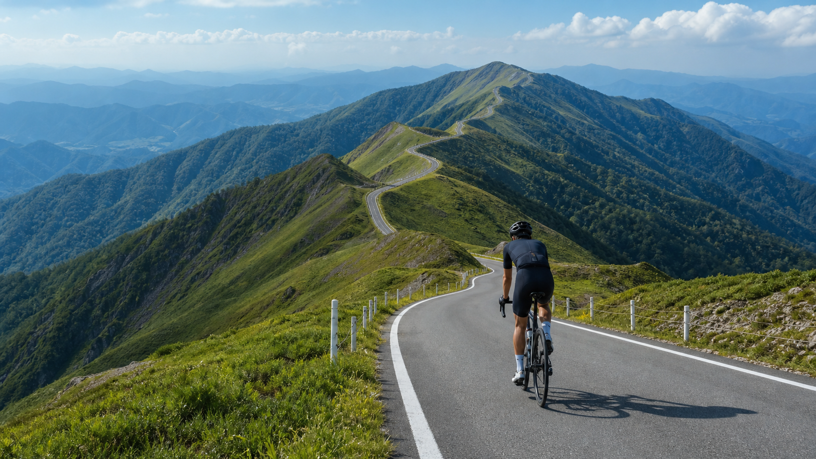
On the ridgeline of the Shikoku Mountains lies a legendary route known among cyclists as the “Sky Road”—the UFO Line (町道瓶ヶ森線, also called the Bottle Cape Forest Road). Unlike Mount Fuji, which is a pure threshold test, this is a completely different challenge: it carries you up to a ridgeline between 1,300 and 1,700 meters above sea level, where over a long distance, endless undulations, and breathtaking scenery, you are repeatedly tempted, drained, and healed. In this article, we break down this road thoroughly in the most practical, data-driven way possible.
Look at the Real Data First: Don’t Be Fooled by the “3.9% Average”
Like with Mount Fuji, I like to quantify the skeleton first. Here are the most core statistics for this route.
| Item | Value | Notes |
|---|---|---|
| Segment Distance | Approx. 42.82 km | Strava popular segment measurement |
| Total Elevation Gain | Approx. 1,808.4 m | Strava segment measurement |
| Average Gradient | Approx. 3.9% | Full-segment average |
| Ridgeline Road Length | Approx. 27 km | Core section along the Shikoku Mountains ridgeline |
| Ridgeline Elevation Range | Approx. 1,300–1,700 m | Undulating within this band |
| Location | Saijō, Ehime Prefecture | Spans the Ehime/Kōchi prefectural border |
At first glance, seeing “average gradient 3.9%” makes many people breathe a sigh of relief: “Only 3.9%? That’s basically a gentle slope.” This is precisely the biggest cognitive trap of this road.
Let’s do the math: 42.82 km with 1,808 meters of climbing means an average rise of about 42 meters per kilometer. But the “3.9% average” figure is an illusion diluted by the large amount of “ridgeline undulation.” The reality is that this road is a classic “rolling ridgeline route”—you’ll constantly climb a bit, descend a bit, then climb again, repeating over and over. The truly cruel part is this: the local climbing sections have gradients far steeper than 3.9%, and every descent mercilessly gives back to gravity the height you just fought so hard to gain, forcing you to climb it all over again.
The average gradient is for planning mileage, not for pacing yourself. What truly determines your suffering is the “wave after wave” rhythm of undulation across those 42 km, plus the sustained pressure of high altitude on your body throughout.
Why a Rolling Ridgeline Route Is Harder to Master Than a Pure Climb
The virtue of a pure climb (like Mount Fuji) is “predictability”—you know it’s all uphill from here, the pacing strategy is simple, and you just pin your power just below threshold and output steadily.
A rolling ridgeline route is an entirely different game. Its difficulty lies in “rhythm management” and “the cost of repeated acceleration”:
- Energy loss from repeated acceleration and deceleration: On every uphill you must output power above your average, and on every downhill you can catch your breath a little, but the recovery from descending is often not enough to fully offset the expenditure of climbing. This pattern of “constantly doing intervals” is actually harder on your energy systems to manage than steady climbing.
- Sawtooth heart rate fluctuations: Your heart rate will spike on every climb and fall on every descent like a sawtooth wave. If you get too greedy on the uphill sections and push your heart rate too high, the accumulated fatigue will come back with interest on every climb in the second half.
- The endurance threshold imposed by distance: 42 km plus 1,808 meters of climbing is a genuine endurance event, where glycogen management and fueling rhythm matter even more than instantaneous power output.
Section-by-Section Strategy: Breaking the UFO Line into Four Chapters
Since this route spans the Ehime/Kōchi prefectural border and connects multiple peaks, I’ll break it into four stages based on riding feel. The actual start and end points depend on the route and direction you choose; the following focuses on the feel of “heading toward the core ridgeline section.”
Chapter 1: The Approach to the Ridgeline—Bank Your Energy First
Before you truly set foot on that dreamlike ridgeline, you need to climb from the base of the mountain to approach ridgeline altitude. This section is usually a relatively sustained climb, with gradients that may be more steady and continuous than the core ridgeline section.
The core strategy for this section is “never overextend.” Many people, out of excitement or a desire to “bank some time while the legs are fresh,” use up too much strength in the approach. This is a huge mistake. Your real challenge—those 27 km of high-altitude, constantly undulating ridgeline—is still ahead. On this section, ride at a comfortable endurance intensity you could sustain “all day,” keep your heart rate a safe margin below threshold, and maintain a high cadence (80 rpm or above), as if saving up for the feast to come.
Chapter 2: First Half of the Core Ridgeline—Dance with the Scenery, But Don’t Get Distracted
When you finally reach the ridgeline and the elevation climbs above 1,300 meters, the whole world opens up. This is the source of the “Sky Road” name—the road winds along the spine of the Shikoku Mountains, with bottomless valleys on both sides and endless peaks in the distance. On a clear day, you can even see the majestic silhouette of Mount Ishizuchi, the highest peak in western Japan.
But remember, from this point on, the road narrows. The ridgeline road has limited width, and you must stay constantly alert for oncoming traffic, especially on blind corners. Cadence management is key in this section: facing wave after wave of undulation, shift down proactively on climbs, spin a higher cadence, and climb with “easy but sustained” power—never stand up and hammer, spiking your heart rate. Descents and short flat sections are your golden windows to recover, hydrate, and take in carbs—make sure to use them.
For pacing, I recommend the discipline of “power ceiling control”: set a power ceiling for each climb that you absolutely will not exceed. Better to climb a little slower than to blow up on a single ascent. Remember, this ridgeline is over twenty kilometers long—you need to save strength for every wave that follows.
Chapter 3: Second Half of the Core Ridgeline—The Double Attack of High Altitude and Fatigue
As the mileage accumulates, you’ve spent a considerable amount of time in the thin air around 1,500 meters, and combined with the toll of all the repeated undulations, you’ll clearly feel “the legs starting to disobey” in this section. The same climb now takes more effort to get up; the same power now produces a higher heart rate.
This is the section where your willpower is tested the most. Physiologically, high altitude slows your recovery; psychologically, the ridgeline’s undulations seem endless. The strategy here is “break it down to zero”: don’t think about how many kilometers remain; focus only on “climbing the one hill right in front of you.” Every time you conquer a wave, give yourself a small acknowledgment. For fueling, this section demands even stricter discipline—hydrate every 20 minutes, take in carbs every 30 to 40 minutes, because if you “hit the wall” here, on a ridgeline with few fueling points at high altitude, your situation will be very dire.
Chapter 4: The Final Section—Bring Your Focus Back to Handling
No matter where your route ends, the final section is often accompanied by descents. Here I want to give a serious reminder: after prolonged high-altitude endurance expenditure, your judgment, reaction speed, and muscle control have all declined significantly compared to when you started. This is exactly when accidents are most likely to happen.
The ridgeline road is narrow, winding, and carries the risk of falling rocks. On descents, be sure to: control your speed, leave braking distance, brake well before corners, and always assume “there may be oncoming traffic or rocks behind the next corner.” Don’t sacrifice safety for a flashy descent segment. You’ve already completed the hardest part—getting home safely is the true finish.
Gearing and Equipment: How to Set Up for a Long Ridgeline
The equipment logic for the UFO Line centers on three keywords: “long duration, repeated undulation, high altitude.”
| Rider Type | Recommended Chainring | Recommended Cassette | Notes |
|---|---|---|---|
| Competitive/Strong Climber | 50/34 compact | 11-32T or 11-34T | Handles local steep undulations while retaining tall gears for descents |
| General Advanced Enthusiast | 50/34 compact | 11-34T | Plenty of bailout gears for repeated undulations, protects the knees |
| Finisher/Endurance-Oriented | 48/32 or 46/30 | 11-34T or lighter | Long distance plus high altitude—better to have gearing too light |
Since this road has many descents and short flat sections, you’ll use the top gears, so it’s not advisable to set up gearing as extremely light as for a pure climb. Instead, aim for “both ends”—light enough gears for local steep sections, and tall enough gears to push on descents.
Other equipment priorities:
- Wheels: For this mixed undulating route, mid-profile wheels are a good balance, combining climbing lightness with descending stability.
- Brakes: With many descents, narrow winding roads, and rockfall risk, brake performance and feel are critical—check them thoroughly before departure. Disc brakes have an advantage in stability on long descents.
- Warm and windproof clothing: As with Mount Fuji, the high-altitude ridgeline is cold and windy; a windproof jacket is essential, especially on descents.
- Repair supplies: The ridgeline is far from town with scarce support points—be sure to carry enough spare tubes, tire repair tools, a pump or CO2, and basic tools. If you get a flat or mechanical failure, you may have no one to turn to.
Fueling and Hydration: Survival Strategy for a Long Ridgeline
This is an endurance battle of 42 km with 1,808 meters of climbing, and fueling points on the ridgeline are extremely scarce—this must be written at the very top of your pre-ride plan.
- Water: Carry plenty of water—two bottles at minimum, or add a hydration bladder. Don’t expect shops or vending machines on the ridgeline. Fill up before departure, and top off at any fueling point in the approach section.
- Carbs: Consume about 30 to 60 grams of carbs every 30 to 45 minutes—energy gels, bars, or sports drinks all work. Long distance plus repeated undulation will rapidly deplete glycogen; once your fueling rhythm collapses, hitting the wall in the latter half is highly likely.
- Meals: Be sure to eat a carb-heavy meal before departure so your glycogen stores are full.
- A self-sufficient mindset: Treat this route as a “semi-self-supported mountain expedition.” What you carry is what you have—this is the most important survival principle of ridgeline riding.
Weather and Seasons: Winter Closure Is a Hard Rule
This route’s seasonal restrictions are far stricter than typical routes, and they’re a hard rule about whether you can even ride.
The road is closed due to snow in winter (roughly late November to early April). This isn’t a “not recommended”—the road is physically closed and impassable. Therefore, planning a ride on this route essentially locks you into the period from late spring to autumn when the road is open.
Even during the open season, the weather on the high-altitude ridgeline remains unpredictable:
- Extreme temperature swings: The temperature difference between the base and the ridgeline is enormous, and with strong ridgeline winds, it can be quite cold even in summer. Windproof and warm clothing is absolutely essential.
- Cloud, fog, and visibility: The ridgeline often has thick fog; when visibility drops suddenly, the narrow, winding environment becomes very dangerous. If you encounter heavy fog, slow down significantly and turn on your lights.
- The reward of clear days: Conversely, if you catch a clear day with excellent visibility, that’s the greatest gift this road can give you—the panoramic views of the Ishizuchi mountain range, or even the Pacific Ocean, will make all the hardship melt away.
Before departure, be sure to check whether the local road is open, as well as the day’s weather and visibility forecast. The weather risk on this route is far higher than typical flatland riding.
Common Mistakes and DNF Risks
Given the characteristics of this route, the most common errors that lead to failure or danger are:
- Underestimating it because of the “3.9% average”: Assuming it’s a gentle slope, preparing insufficiently for pacing and fueling, then being crushed by the repeated undulations and long distance.
- Overextending in the approach: Using up your legs before reaching the ridgeline, leaving you struggling painfully through the best part of the route.
- Insufficient fueling preparation: Underestimating how scarce fueling points are on the ridgeline, running out of water or food, and running on empty in the middle-to-late sections.
- Ignoring descent and handling risks: Pushing too hard on narrow, winding descents with rockfall risk while fatigued—this is the main cause of accidents.
- Insufficient repair supplies: Getting a flat or mechanical failure on a remote ridgeline with no tools, leaving you stuck between a rock and a hard place.
- Forcing through during closure season or bad weather: Ignoring winter closures or fog warnings and putting yourself in high-risk situations.
Target Time Table for Riders of Different Levels
The following time table is based on the full segment (approx. 42.82 km, approx. 1,808 m of climbing). Since this route’s undulations are complex and heavily affected by weather and road conditions, these figures are only for rough self-positioning—actual times will vary widely.
| Rider Level | Reference Finish Time | Pacing Advice |
|---|---|---|
| Top Amateur/Strong | Under approx. 2 hours | Disciplined power management throughout, steady engagement with ridgeline undulations |
| Experienced Enthusiast | Approx. 2 hrs–2 hrs 40 min | Conservative approach, break the ridgeline into small pieces |
| Advanced Finisher-Oriented | Approx. 2 hrs 40 min–3 hrs 30 min | Steady endurance focus, fully use descents to recover |
| General Recreational Challenge | Approx. 3 hrs 30 min or more (incl. photo stops) | Ride within your limits, put scenery and safety ahead of time |
I want to emphasize: the value of this route has never been about how fast you ride, but whether you can safely and completely store this ridgeline scenery in your memory. Treat the time table as a reference, not a source of pressure.
Training Preparation Suggestions
If you decide to take on the UFO Line, your pre-ride training focus differs slightly from a pure climb and should emphasize “undulation endurance” and “long-ride capability”:
- Long endurance rides: Regularly do rides of 3+ hours with substantial climbing to train your glycogen management and sustained output.
- Rolling intervals: Find a rolling route and practice the rhythm control of “don’t blow up on climbs, recover on descents”—this is the core skill for handling ridgeline undulations.
- Climbing muscular endurance: Accumulate enough climbing volume so your legs can withstand the fatigue of repeated ascents.
- Descending technique: Master long, winding descent handling and brake control in a safe environment—this is about your safety.
Conclusion: A Road Worth Trading an Entire Day For
The UFO Line is not a road you “ride through on the way.” It demands serious preparation, careful planning, and respect for its distance, high altitude, weather, and road conditions. But when you truly pedal onto that ridgeline floating above the clouds, watching the road extend endlessly along the mountains’ spine toward the distant Ishizuchi range, you’ll fully understand why generation after generation of cyclists travel from afar to Shikoku, just to meet this “Sky Road.”
It tests not just your legs, but your planning, your discipline, your patience, and your reverence for the mountains. When you’re ready, go—but please, always place safety and reverence ahead of performance.
Power Management on Ridgelines: Learning to “Shave Peaks and Fill Valleys”
As mentioned earlier, the biggest difficulty of this road is the energy loss from repeated undulation. Here I want to give a more concrete power management principle, which I call “shave peaks and fill valleys.”
“Shaving peaks” means actively suppressing your power spikes on every uphill section. Human instinct is “see a hill, want to hammer up it,” but on a ridgeline with countless hills, this instinct is fatal. The correct approach is to set a power ceiling for each climb (e.g., 90% of FTP), and once you approach it, shift down, spin a higher cadence, and climb “slower but steadier.” Shaving off these unnecessary power spikes can dramatically conserve your precious glycogen and leg strength.
“Filling valleys” means that on every descent and flat section, don’t completely stop outputting and let yourself “lie flat,” but maintain a gentle, low-power pedal that promotes blood circulation and lactate clearance. This lets you recover more effectively on descents and prepare for the next climb.
The ultimate goal of “shave peaks and fill valleys” is to “iron out” your originally sawtooth, wildly fluctuating power and heart rate curves as much as possible. The smoother the curve, the more efficient your energy use, and the better you can last to the end on this long ridgeline. This is the golden rule for all rolling routes, worth practicing repeatedly until it becomes instinct.
Pre-Ride Advice for First-Time Challengers
If this is your first time tackling a route with this combination of “long distance + high altitude + ridgeline undulation,” I’d like to offer you a few sincere words of advice as someone who’s been there:
- Treat it as an expedition, not a ride. From transportation, accommodation, road-open status checks, weather confirmation, fueling preparation, to equipment and repair supplies—every aspect needs careful planning. This road doesn’t allow for “just going on a whim.”
- Lower your expectations for performance, raise your emphasis on safety. On your first ride, your goal should be to “finish it safely, completely, and happily,” not to chase any time. Speed can wait until next time, but safety has no next time.
- Ride with companions. In this remote mountain area with scarce support, having partners to look out for each other—whether for mechanical failures, physical discomfort, or sudden weather changes—greatly increases your safety margin.
- Know your limits and always keep the option to retreat. If something feels physically wrong, the weather deteriorates sharply, or you’re clearly running out of strength, don’t hesitate to turn back or rest. The mountain will always be there; going home healthy is what gives you the chance for a next meeting.
Remember, the most remarkable ability of a mature cyclist is not how fast they ride, but knowing how to make the right judgment at the right time. May you both harvest the scenery and return safely on this Sky Road.
The Invisible Opponent of High Altitude: How Thin Air Steals Your Performance
This route runs almost entirely above 1,300 meters, and spending extended time in the high-altitude ridgeline environment has real effects on your body that you won’t feel on flatland rides. Understanding them is the key to responding correctly.
First is “decreased oxygen intake.” The higher the altitude, the thinner the air, and the less oxygen each breath delivers. This means at the same power output, your cardiorespiratory system must work harder—your heart rate will be higher and breathing more labored than at sea level. You’ll clearly feel “the same climb is more breathless than at low altitude.” This isn’t you getting weaker; it’s the environment.
Second is “slower recovery.” On a rolling ridgeline like this, you rely heavily on descents and flats for recovery; but in a hypoxic environment, your body’s efficiency at clearing lactate and replenishing energy decreases, so your recovery after each climb is less complete than at low altitude. This is precisely why “shave peaks and fill valleys” power management matters more on a high-altitude ridgeline than anywhere else.
Finally, there’s “declining judgment and coordination.” Mild hypoxia can slow your reactions and impair concentration—a potential danger factor on a ridgeline that is narrow, winding, and carries risks of rockfall and oncoming traffic. Therefore, the further into the ride and the more fatigued you feel, the more deliberately you must raise your alertness, especially on descents and through corners.
Against these invisible opponents, the best strategy is always “conservatism” and “adaptation”: proactively lower your expectations for power numbers, strictly execute your fueling plan, always keep a reserve of energy, and keep your safety awareness at maximum. This road rewards smart riders who know how to make peace with the environment, not reckless ones who charge head-on.
A Bike Suited to This Road: More Than Just a Road Bike Choice
Although this article has been discussing pacing and gearing from a road bike perspective, I want to add: a route like the UFO Line—“long distance, lots of undulation, road conditions requiring attention to rockfall, and a pursuit of scenic experience”—is actually quite accommodating in terms of bike type.
If you’re chasing pure climbing efficiency and speed, a lightweight road bike with well-chosen gearing remains the sharpest weapon. But if you value comfort on long rides and stability and confidence on potentially imperfect pavement, then the increasingly popular “gravel bike” or “endurance road bike” are also very worthy considerations. These bikes typically have more forgiving geometry, can accommodate wider tires, and offer a more comfortable riding position, allowing you to devote more mental energy to enjoying the scenery rather than fighting the road surface over a long ridgeline ride.
Whichever bike you choose, the core principles remain unchanged: ensure its braking system is reliable, gearing is sufficient for the undulations, tires are in good condition, and it has received a complete pre-ride service. On a ridgeline far from civilization, the reliability of your bike directly relates to your safety.
Handling “Oncoming Traffic” and “Rockfall”: Two Practical Issues on Ridgeline Roads
This guide wouldn’t be complete without clearly addressing “oncoming traffic” and “rockfall.” They are the two safety issues on this ridgeline route that demand your constant vigilance in practice.
First, oncoming traffic. The ridgeline road has limited width—some sections can barely fit a single vehicle—and with many corners and sightlines often blocked by terrain or fog, “not seeing oncoming traffic” is the norm. You must internalize the thought “behind every blind corner, there could be a vehicle coming toward me” as instinct. Concretely: when cornering, stay to your side and slow down; better to sacrifice a little speed than to leave yourself no room to react or dodge. This is especially true on descending corners, because high speed on descents drastically compresses your reaction time. When passing cars or motorcycles, proactively slowing down and yielding to the side is the safest choice.
Next, rockfall. Mountain ridgelines are affected by weathering, rain, and geological processes, and it’s not uncommon to find rocks of various sizes on the road surface, especially after rain or on geologically unstable sections. While riding, your eyes can’t just fix on the road ahead; you need to scan the surface periodically, watching for any loose gravel, potholes, or obstacles. If you spot rocks, never brake suddenly or jerk the handlebars (which can easily cause a loss-of-control crash at high speed on descents); instead, decelerate early and smoothly and ride around them. For tires, choosing models with good grip and puncture resistance adds another layer of protection.
These two issues may sound daunting, but don’t let them scare you away from this road. As long as you maintain proper alertness, control your speed, and leave yourself margin, these risks are entirely manageable. What’s truly dangerous is never the road itself, but the mindset of losing vigilance and charging ahead recklessly.
The Final Lesson Before the Conclusion: Respect Is the Highest Cycling Wisdom
Writing to this point, I want to leave you with the deepest lesson this road has taught me: “respect.”
Respect the road’s distance—its 42 km length does not allow you to take preparation lightly; respect its high altitude—the thin air will honestly reflect itself in every breath and heartbeat; respect its weather—the winter closures and summer fog are boundaries drawn by nature that cannot be challenged; respect its road conditions—narrow, winding, with rockfall, each factor reminds you to put safety first; and respect your own body—when it sends warning signals, know how to listen, know when to step back, and know how to preserve the chance for another meeting.
When you step onto the UFO Line with this complete respect, it ceases to be a “dangerous” road and becomes a “worthy” one—worthy of your serious preparation, worthy of your full effort, and worthy of the genuine pride you’ll feel upon completion for your thorough, mature, and reverent cycling wisdom. This is the most precious medal of a true ridgeline rider.
Related Reading
- Encountering the Sky Above the Peaks: The UFO Legend of the UFO Line, the Ishizuchi Mountain Range, and a Once-in-a-Lifetime Scenic Ride
- Shikoku Karst Sky Road Practical Guide: 13.6 km of Scenic Highland, Top-Tier Views for Moderate Difficulty
- Wulai Fushan Tribe Full Analysis: 14.4 km Riverside Forest Road—What Terrain Traps Lie Behind the 1.4% Average Gradient
- Kirishima Ebino Highland Climb Practical Guide: Full Data Analysis of a 12 km, 861 m Climb on a Volcanic Highland
台北闊瀨陡坡 騎旅 / 日本單車雜誌編輯車友臨時加入!/ 髮香才是最強的 / feat. 北迴歸線小隊 / 公路車 CT Yeh
6 個月前
台灣登山王之路 KOM 全程參賽4K臨空錄影 PART1 穿越峽谷地形! #東進武嶺 太魯閣 / 燕子口 / 天祥 / 西寶 PART1 (公路車 / CT Yeh)
3 年前
半日 小台灣 極限單車路線挑戰實錄
7 年前
新竹羅平 x 天湖部落 大禹嶺級變態陡坡! 4K超高畫質 空拍 | 公路車
5 年前
西進武嶺 世界紀錄挑戰!破2:30 ?!一群人推著一個夢上山 直播精華版 / ft. 張翰允 & 台視主播魏于恬 & KPLUS / #cycling 公路車 CT Yeh
2 個月前
萬年峽谷! 30% 超激陡坡 里佳部落DAY2 還是很硬! | 公路車 | CT Yeh
3 年前
大禹嶺 到 武嶺牌樓 全程前後實況錄影 | 北進武嶺 | 東進武嶺 | KOM | 訓練台 | 坡度分析 | Taiwan KOM Last 10 km HARD | 公路車
6 年前
風櫃嘴時間 預測西進武嶺時間?13000名車友統計數據分析告訴你 !
5 年前