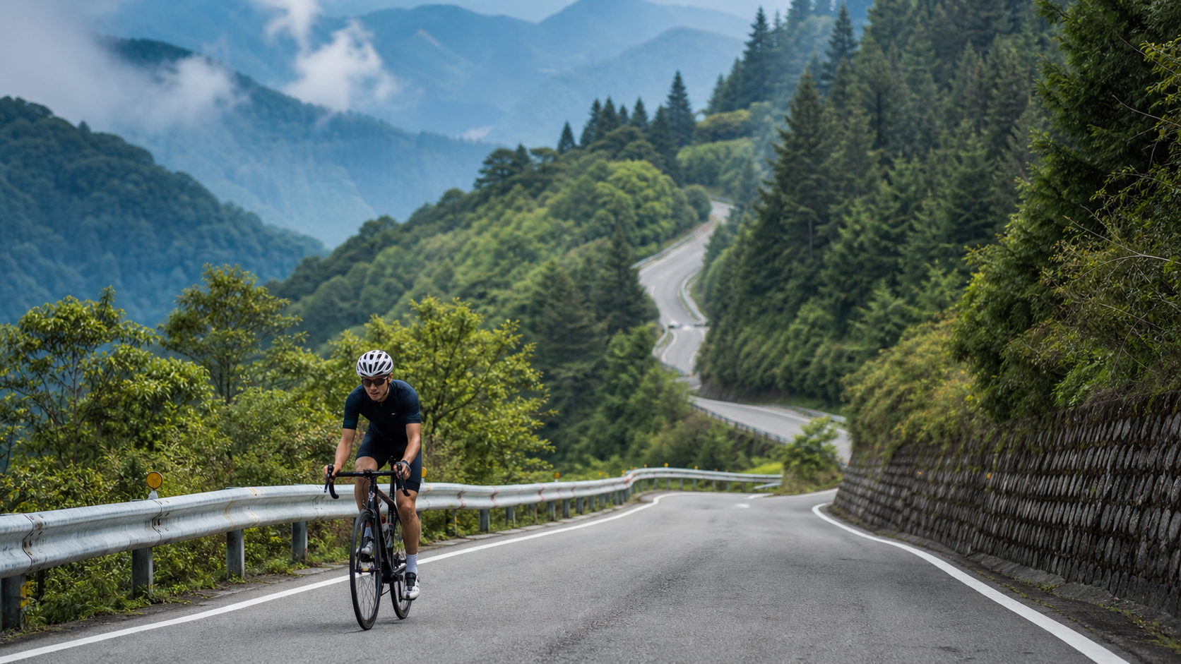
On Taichung’s climbing spectrum, if Wanggaoliao is a sprint, then Dasyueshan is a full marathon. The route is 32.43 km long with a total elevation gain of about 1,557 meters and an average gradient of 4.7%. Starting from Dongshi, it climbs steadily, with the forest changing from broadleaf, to mixed broadleaf-conifer, and finally to natural coniferous forest as altitude increases, ending at the Xiaoxueshan Tianchi (Sky Lake) at about 2,600 meters above sea level. Many people say Dasyueshan is “easy to climb”—because the gradient is consistent with no brutal steep sections; but others crack on it—because 32 kilometers of length and 1,500 meters of climbing are the most honest test of endurance and pacing discipline. This article takes an engineer’s perspective to break this mountain down into an executable, segment-by-segment plan.
Route Overview and Data Analysis
| Item | Data |
|---|---|
| Total Route Length | Approx. 32.43 km |
| Total Elevation Gain | Approx. 1,557 m |
| Average Gradient | 4.7% |
| Start Point | Dongshi (near Fengshi Rd / Dongkeng Rd intersection) |
| Waypoints | Dadong Police Station, Henglingshan Tunnel, Tianchi (approx. 2,600m elevation) |
| Route Category | Long-distance endurance climb |
The Dasyueshan Forest Road starts at the intersection of Fengshi Road and Dongkeng Road. From the start to Dadong Police Station is about 15 km with an average gradient of about 4%, a steady gentle climb the whole way. After Dadong Police Station, the main climbing section begins—about 12 km with roughly 800 meters of elevation gain, where the gradient steepens. The character of the entire route is clear: “Gentle at first, steady later, no steep sections—it’s about endurance, not explosive power.” Precisely because the gradient is consistent with no intimidating brutal slopes, Dasyueshan is especially well-suited for training “steady power output on long climbs”—that’s where its training value lies.
Segment-by-Segment Strategy
Segment 1: Dongshi to Dadong Police Station (0–15 km, approx. 4% gradient)
Starting from Dongshi, the first 15 km to Dadong Police Station is a gentle warm-up and rhythm-building section with an average gradient of about 4%. The biggest trap here is “riding too fast because it feels too comfortable.” The 4% gradient gives you the capacity to push hard, and many riders burn half their legs in the first 15 km, only to collapse on the real climbing ahead. Be sure to keep your heart rate in the aerobic zone (70–78% of max heart rate), use a high cadence of 80–90 rpm, and treat these 15 km as a “warm-up” rather than a “race.” Along the way, the forest begins as broadleaf, and the air grows increasingly fresh.
Segment 2: Dadong Police Station to Henglingshan Tunnel (15–26 km, 6–7% gradient)
Past Dadong Police Station, the real Dasyueshan begins. This section is about 11 km with roughly 727 meters of elevation gain and an average gradient of about 6.7%—the core section with the most “climbing feel” on the entire route. This is where your earlier pacing is put to the test—if you paced the first 15 km well, you still have legs here; if you paced poorly, this is where you start putting a foot down. Although the gradient rises to 6–7%, it remains steady and linear, without the torment of sudden steep-and-shallow changes. Shift to a lighter gear, maintain 70–80 rpm, and keep your heart rate near—but not above—your lactate threshold. The forest here transitions to mixed broadleaf-conifer, and the Henglingshan Tunnel is a major milestone; passing it means you’ve completed the bulk of the main climbing.
Segment 3: Henglingshan Tunnel to Tianchi (26–32 km)
Past the Henglingshan Tunnel, you’re already at high altitude—the air is thinner, temperatures drop sharply, and the forest turns to natural coniferous woodland. That cold, crisp scent of pine is something only found at elevation. On these final few kilometers, the gradient remains, but the scenery and sense of accomplishment will carry you forward. Tianchi sits on the southern ridge of Xiaoxueshan at about 2,600 meters—a high-mountain lake that never runs dry year-round. At this point, your biggest enemy isn’t the gradient, but the fatigue from low temperatures and high altitude. Slow your pace, steady your breathing, and get yourself safely to the end of this mountain.
Gear Ratio and Equipment Recommendations
- Chainring/Cassette: Compact crankset (50/34T) paired with an 11–32T or 11–34T cassette is the standard setup for Dasyueshan. Although the gradient is consistent, the accumulated fatigue over 32 km makes the 6–7% sections in the latter half feel heavier, and a wide gear range lets you maintain cadence and protect your knees in the later stages.
- Wheels: For long climbs, lighter is better—low-profile lightweight wheels reduce cumulative burden.
- Warmth: This is critical. The temperature difference between Dongshi at the bottom and Tianchi can exceed 10–15°C, compounded by wind chill on the descent. Be sure to carry a windbreaker, full-finger gloves, and even arm warmers and leg warmers. Hypothermia over a 32 km descent is a real risk.
- Lighting and Tools: The Henglingshan Tunnel requires bike lights. Supply points in the mountain area are scarce, so be sure to bring your own tire repair tools and spare inner tubes.
Nutrition and Hydration
One of the biggest challenges of Dasyueshan is the “scarcity of supply points.” This is a forest recreation area’s forest road, not a busy tourist highway.
- Before heading up: Be sure to fill all your bottles in Dongshi town (two or more recommended) and stock up on energy supplies (gels, bars, bananas). Supplies are extremely limited once you’re on the mountain—don’t expect to buy anything along the way.
- Feeding rhythm: For a 32 km ride lasting possibly 2–3 hours or more, follow a rhythm of 30–60 grams of carbohydrates per hour and hydration every 15–20 minutes.
- Dadong Police Station: Can serve as a mid-ride rest point and a checkpoint to assess your condition.
- Park entry information: Dasyueshan National Forest Recreation Area has entry regulations and time restrictions. Be sure to check the latest opening hours and fees before departure to avoid being turned away (this information is subject to change; please refer to official announcements).
Weather and Seasons
- Spring/Autumn (March–May, October–November): The best riding seasons—stable weather, good visibility, and beautiful forest scenery (the conifers are especially atmospheric in autumn).
- Summer: Hot at the bottom but cool in the mountains, making it a great choice for an escape-the-heat climb. However, afternoon fog and thunderstorms are common, so start early and return early.
- Winter: High elevations may bring low temperatures or even frost, with slippery roads. Warmth and safety risks rise significantly; not recommended for non-experts.
- General reminder: High-altitude weather is changeable. When fog rolls in, visibility drops sharply—be sure to turn on your lights and slow down.
Common Mistakes and DNF Risks
- Riding the first 15 km too fast: Fooled by the 4% gentle gradient, you blow your legs in the warm-up section—this is the number one cause of DNFs on Dasyueshan.
- Insufficient supplies: Underestimating how few supply points exist on the forest road, you run out of water and food mid-ride and bonk.
- Insufficient warmth: Focusing only on how hot you get while climbing, you ignore the low temperatures at Tianchi and the risk of hypothermia on the descent, leading to shivering and stiff fingers that compromise bike handling.
- Poor time management: Failing to account for the forest recreation area’s opening and closing times, or failing to get down before dark. Always leave ample buffer time for the descent.
- Riding solo recklessly: The forest road has sparse traffic and unreliable phone signals. If you get into trouble alone on Dasyueshan, getting help is difficult—riding with companions is recommended.
Reference Times for Riders of Different Levels (Full 32.43 km)
| Rider Level | Reference Time | Corresponding Intensity |
|---|---|---|
| Beginner / Finish-oriented | 3.5–4.5 hours | All-aerobic, goal is to finish |
| Intermediate | 2.5–3.5 hours | Steady cruising, no foot-down in the latter half |
| Competitive | 2–2.5 hours | Near threshold, chasing time |
Dasyueshan isn’t a place to test explosive power—it’s a place to test “who can sustain a steady output to the very end.” The real battle is how much leg you have left for the final 17 km.
Physical and Mental Preparation for Long Climbs
The 32 km length of Dasyueshan tests not just your legs, but your “preparation.” Half the battle for a successful Dasyueshan ride is decided before you even set off.
Physical Check Before Departure
- Don’t overtrain the week before: Leave enough recovery time and arrive with fresh legs, not pushing through fatigue.
- Sleep and diet: Get a full night’s sleep the day before, and eat plenty of carbohydrates on the day (breakfast should be more substantial than usual)—long climbs run on glycogen stores.
- Progress gradually: Don’t make Dasyueshan your first big mountain. Build your foundation on Zhongxingling, Dakeng, and Wanggaoliao first. Once you can consistently complete a 1,000-meter climb, then take on Dasyueshan’s 1,557 meters.
Mental Preparation
On a 32 km climb, your biggest enemy is often the “mind demon.” When you’re halfway up and realize how much road lies ahead, the urge to quit easily creeps in. The counter-strategy is “chunking the goal”—don’t think about 32 km; just think “ride to Dadong Police Station first,” then “to Henglingshan Tunnel.” Break the mountain down into achievable milestones and complete it one segment at a time.
High-Altitude Effects on the Body and Countermeasures
The highest point of Dasyueshan approaches 2,600 meters, and the physiological challenges of altitude should not be underestimated:
- Thinner air: The higher you go, the lower the partial pressure of oxygen, and the same power output feels more breathless. The countermeasure is to “actively downshift”—the higher you get, the more deliberately you should lighten your gear and lower your target power. Don’t compare yourself to your sea-level numbers.
- Rapid temperature drop: From Dongshi at the bottom to Tianchi, the temperature difference can exceed 10–15°C. While climbing, your body generates heat and you don’t feel cold, but the moment you stop or descend, hypothermia sets in fast. The countermeasure is to carry ample warm layers and put them on before descending.
- UV and dehydration: At high altitude, UV is intense and the air is dry, so dehydration risk is often underestimated. Sunscreen and regular hydration are both non-negotiable.
- Altitude sickness: A small number of people experience headache or nausea when rapidly ascending above 2,000 meters. If symptoms are pronounced, be sure to slow down or turn back—don’t push through it.
The Descent: The Underrated True Test
Many people focus all their attention on “how to climb up,” overlooking that the 32 km descent of Dasyueshan is where the real danger lies.
- Hypothermia: On the descent you’re not generating power, wind chill is in effect, and combined with the already-low mountain temperatures, hypothermia over a long descent is the number one risk. Be sure to put on your windbreaker, warm layers, and full-finger gloves before descending.
- Brake overheating: Over a continuous 32 km descent, holding the brakes constantly causes rims or rotors to overheat and braking power to fade. Be sure to “pulse” the brakes intermittently, giving them time to cool—don’t drag them the whole way.
- Dropping focus: After climbing 32 km, you’re exhausted, and focus easily wanders on the descent. Combined with numerous corners, this is a high-risk period for crashes. Stay focused and control your speed.
- Tires and road conditions: Mountain forest roads may have rockfall, gravel, or wet leaves. On the descent, anticipate and slow down through corners.
Remember: getting down safely is what makes a successful Dasyueshan ride.
Practical Nutrition: Self-Sufficiency on the Forest Road
Dasyueshan is a forest road in a forest recreation area, with extremely scarce supply points—which means you must be “self-sufficient.”
- Water: At least two bottles (1.5 liters or more). Long climbs make you sweat a lot—better to carry extra.
- Solid energy: Energy bars, bananas, rice balls—carbohydrates that are shelf-stable and easy to digest. Replenish at 30–60 grams of carbs per hour.
- Quick energy: 2–3 energy gels as emergency fuel for when you hit the wall in the latter stages.
- Electrolytes: Especially important in summer to prevent cramping. Use electrolyte tablets or sports drinks.
- Emergency reserve: Bring one extra portion in case the ride takes longer than expected.
Better to carry a little extra than to run short. On a forest road with no civilization in sight, your supplies are your lifeline.
Power-Based Pacing for Long Climbs: Let Numbers Keep Your Discipline
The 32 km length of Dasyueshan makes “feel” unreliable—by the latter stages, fatigue distorts your perception of intensity. That’s where a power meter (or, failing that, a heart rate monitor) becomes your tool for maintaining discipline.
Principles of Power-Based Pacing
- Set a target range: Based on your FTP, for a long climb it’s recommended to set your target power at 75–85% of FTP (depending on your fitness and goals). Aim for the lower end in the early stages; in the latter stages, just maintaining it is enough.
- Watch normalized power (NP): Long climbs inevitably have undulations. Don’t obsess over momentary power fluctuations—instead, watch whether your overall NP stays in the target range.
- Watch for “power drift”: If you find that maintaining the same power requires a progressively higher heart rate (heart rate drift), it means fatigue or dehydration is accumulating—time to step up nutrition or even lower your target.
What If You Don’t Have a Power Meter
Use heart rate pacing: set your upper heart rate limit below your lactate threshold heart rate, and be more conservative in the early stages. Combine this with the “talk test”—if you’re too breathless to string together a short sentence, your intensity is too high and you need to slow down.
Hold the numbers, and you hold your chance of finishing Dasyueshan.
Dasyueshan vs. Wuling: A Dress Rehearsal of Strength
Many riders treat Dasyueshan as a “dress rehearsal before Wuling”—and that’s a very accurate framing.
Wuling is the highest point on Taiwan’s roads (about 3,275 meters). Starting from Puli on the west side, it’s an ultimate challenge of over 50 km with more than 3,000 meters of climbing. Dasyueshan’s scale—32 km, 1,557 meters of climbing, and a high point near 2,600 meters—is precisely a “scaled-down rehearsal” for Wuling. It tests the same things: long-distance endurance, high-altitude adaptation, nutrition and warmth strategies, and managing hypothermia on the descent.
If you can’t yet consistently complete Dasyueshan, attempting Wuling recklessly is dangerous. Conversely, if you ride Dasyueshan smoothly and rehearse all the challenges above, you’ll have a solid basis for judging “whether you can make it up Wuling.” Dasyueshan is the most worthwhile practical lesson to tackle before the highest point on Taiwan’s roads.
Team Riding: Division of Roles and Safety
The Dasyueshan forest road has sparse traffic and unreliable signals, so riding with companions is strongly recommended. Team riding also has its own wisdom:
- Divide the pace: On a long climb, there’s no need to force everyone to ride together. Each rider climbs at their own suitable pace, and agree to regroup at key waypoints (such as Dadong Police Station or Henglingshan Tunnel).
- Look out for each other: Keep an eye on your teammates’ condition. If someone is clearly dropping pace, looking unwell, or showing signs of altitude sickness, stop and help promptly.
- Share supplies and tools: The team can split the burden of carrying repair tools and first-aid supplies, reducing the load on each individual.
- Segment the descent: Don’t bunch up on the descent—maintain safe spacing and each rider controls their own speed.
- Communication agreement: When signals are unreliable, agree on meeting points and wait times in advance to avoid getting separated.
A safe Dasyueshan ride depends not just on individual fitness, but on team coordination and mutual care. Put safety ahead of performance, and every mountain journey will end safely and successfully.
Common Q&A: What to Know Before Taking on Dasyueshan
Q: I’ve never ridden a big mountain. Can I take on Dasyueshan directly?
Not recommended. Dasyueshan—32 km, 1,557 meters of climbing, and a high point near 2,600 meters—is a serious high-altitude long climb. It’s recommended to first build your climbing foundation on routes like Zhongxingling and Dakeng. Once you can consistently complete about 1,000 meters of climbing, then take on Dasyueshan. Progress gradually to stay safe and enjoy it.
Q: How much water and food should I prepare?
At least two bottles of water (1.5 liters or more), increasing based on weather and your personal sweat rate. Prepare energy supplies at 30–60 grams of carbohydrates per hour, plus one extra emergency portion. Supply points on the forest road are scarce—better to carry more.
Q: Is riding with companions mandatory?
Strongly recommended. The forest road has sparse traffic and unreliable signals, making it difficult to get help if you’re alone and in trouble. Riding with companions isn’t just safer—it also allows mutual support and sharing of gear.
Q: Can I schedule other activities on the same day after the ride?
Not recommended. Dasyueshan is a time-consuming, energy-draining outing. Including the descent, it can take up most of the day, and you’ll be physically spent afterward. Treat it as a full-day main event and leave ample recovery time.
Reading Dasyueshan’s Weather
High-altitude weather is changeable, and learning to read the weather is a key skill for riding Dasyueshan safely.
Before departure: Check the weather forecast for the Lishan and Heping areas, paying special attention to temperature, chance of rain, and afternoon thunderstorms. If the forecast is significantly poor, reschedule rather than risk it.
Observations while riding:
- Cloud changes: If you see cumulus clouds building rapidly and the sky darkening, it may signal an approaching thunderstorm—stay alert and consider turning back early.
- Fog: High altitudes often bring afternoon fog, and visibility drops sharply. When fog rolls in, turn on your lights, slow down, or even stop and wait.
- Sudden temperature drop: A sudden drop in temperature often heralds a weather change—add warm layers promptly.
- Wind direction and speed: Pay attention to wind changes; strong winds can affect bike handling and perceived temperature.
Decision principle: In the mountains, safety always comes before completing the goal. If the weather turns, decisively turn back or stop—the mountain will always be there, and opportunities will come again, but you only have one safety. Learning to read the weather and learning to say “no” at the right moment is the wisdom of a mature rider. Dasyueshan tests not just your fitness, but your reverence for and judgment of the mountain. Master this skill, and you’ll be able to safely enjoy high-mountain riding on future challenges like Wuling and Hehuan.
Nutrition Strategy for Long Climbs: From Pre-Ride to Post-Ride
For a long, high-output climb like Dasyueshan, nutrition strategy is no less important than physical training. A complete nutrition strategy spans three phases: pre-ride, during-ride, and post-ride.
Pre-ride (the day before to departure): Start increasing carbohydrate intake the day before (a simplified version of the “glycogen supercompensation” concept) to top off your muscle and liver glycogen stores. On departure day, eat a more substantial breakfast than usual—focusing on easily digestible carbohydrates (such as congee, bread, bananas)—and allow enough digestion time before setting off.
During the ride: A long climb is a sustained energy-burn battle. The principle is “small amounts, frequent intervals, don’t wait until you’re hungry”—refuel every 15–20 minutes, take in 30–60 grams of carbohydrates per hour, alternating between solid (energy bars, bananas) and liquid (energy gels, sports drinks) sources. Hydrate every 15 minutes, and add electrolytes in summer to prevent cramping. At high altitude, appetite may decrease, so rely on discipline to remind yourself to refuel.
Post-ride (after finishing): The 30 minutes after finishing are the golden window for replenishment—carbohydrates to restore glycogen and protein to repair muscle. A full meal plus plenty of fluids will dramatically speed up recovery.
Execute this nutrition strategy properly, and you won’t just complete Dasyueshan more smoothly—you’ll also reduce the risk of bonking and cramping, and recover from fatigue faster. Nutrition is the most overlooked factor in long-climb performance, yet the one that can make the biggest difference. It’s just as important as physical training—you could even say that fueling is the second engine of a long climb.
What Long Climbs Taught Me About Patience
The long, drawn-out climb of Dasyueshan taught me its most precious lesson: “patience.” In an era that prizes instant results and immediate gratification, patience has become a scarce virtue. We’re used to things working right away and being satisfied immediately. The moment something requires a long wait and accumulation, we grow restless and give up.
But Dasyueshan doesn’t play that game. Its thirty-plus kilometers of length and over fifteen hundred meters of climbing cannot be conquered in one leap. You can’t force it with brute strength—you can only grind it out one kilometer at a time, one segment at a time, with patience. It forces you to let go of the obsession with “arriving immediately,” to learn to enjoy the process, to learn to coexist with the long haul, and to learn to trust that “as long as you keep moving forward, you will eventually arrive.”
This patience, honed on long climbs, seeps into every corner of life. When you face a goal that requires long-term investment before results appear—learning a skill, nurturing a relationship, completing a major undertaking—you’ll think of Dasyueshan. You’ll remember how you used patience to ride an seemingly endless mountain, step by step, to the top. You’ll understand that truly valuable things are never achieved overnight; they require time, accumulation, and that kind of patience that says “not in a hurry for the moment, only committed to steady progress.” Dasyueshan, with its sheer length, carved this patience into my bones. And this patience has served me more in life than any physical gain ever could.
May You Meet a Better Self in the Mountains
Dasyueshan is not just a mountain—it’s a mirror that reflects who you are. In its long climb, thin air, and vast forests, you’ll meet the most authentic version of yourself that everyday life often hides—your endurance and your fragility, your persistence and your retreat, your smallness and your potential.
And every time you converse with this mountain, every time you pass through its trials, you become a little better than before—more humble, more resilient, more grateful and reverent. Perhaps this is the deeper reason we keep riding toward the mountains: not to conquer them, but to meet—and become—a better version of ourselves in their presence. May you, too, meet the self you’ve always wanted to become in the thousand-year-old forests of Dasyueshan.
Conclusion
Dasyueshan: 32.43 km, 1,557 meters of climbing, 4.7% average gradient. It’s “easy” because it doesn’t torment you with brutal steep sections; it’s “not to be trifled with” because 32 kilometers of length will honestly expose every flaw in your pacing. It tests endurance, discipline, preparation, and reverence for the risks of high altitude and the descent. Bring enough supplies, carry enough warmth, suppress the urge to ride fast in the first 15 km, stay focused on the descent, and use endurance and wisdom to ride this mountain that rises gently from Dongshi—safely up, and safely down. When you’ve done that, you’ve graduated from “someone who can ride hills” to “someone who understands big mountains.”
Related Reading
- Dasyueshan Forest Road Cycling Challenge: Taichung’s Hidden Primitive Forest Climb
- The Road to Dasyueshan in Taichung: 200 Forest Road vs. Dongmaoshan Forest Road Full Comparison
- Dasyueshan Forest Road Full Climb Guide: 20km of Uninterrupted 6.2% Climbing, a Threshold Endurance Test
- Sacred Trees and Sky Lake in the Clouds: A Cycling Pilgrimage to Dasyueshan, Riding Altitude as a Practice
台中大雪山 膏王領騎 震到都沒畫面了 公路車
5 年前
爬坡ITT實境)台中 魔王 松鼠坡 首航 6:12 大肚山 大三元 科福路
8 年前
台北闊瀨陡坡 騎旅 / 日本單車雜誌編輯車友臨時加入!/ 髮香才是最強的 / feat. 北迴歸線小隊 / 公路車 CT Yeh
6 個月前
半日 小台灣 極限單車路線挑戰實錄
7 年前
大武山後門26%歡樂陡坡!JJSC南台灣單車行Day2 / 被颱風追著跑 / 公路車 / CT Yeh
2 年前
騎單車去大屯山賞雪! 助航台滑冰 全記錄 | 台北R友大集合 | 下雪打雪仗囉 | 4K超高畫質
5 年前
大武山20%魔王陡坡【JJSC南台灣遊騎Day2】!屁股真的要裂開了...凡士林抹滿也沒用?神秘金教堂還有超便宜夜市
3 個月前
新竹羅平 x 天湖部落 大禹嶺級變態陡坡! 4K超高畫質 空拍 | 公路車
5 年前