Qingquan Bridge to Lishan Practical Guide: 8.6 km to Conquer the Central Cross-Island Highway Hub, Climbing Straight to Lishan at 2,000 Meters Above Sea Level
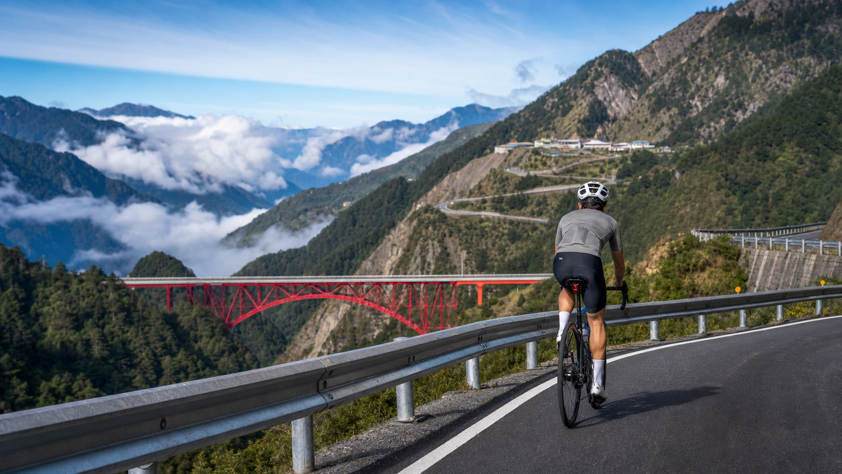
Lishan, at an elevation of nearly 2,000 meters, is the hub of Taiwan’s Central Cross-Island Highway—where Provincial Highway 8 and Provincial Highway 7A meet. From here, you can descend east to Taroko, head north through Siyuan Pass to Yilan, or go west to Guguan (the main line of the Central Cross-Island Highway). The 8.6-kilometer stretch from Qingquan Bridge to Lishan, with a climb of approximately 394 meters and an average gradient of 4.5%, is the final ascent before reaching Lishan. Qingquan Bridge, a bridge featuring a red steel structure, is located at approximately 65K on Provincial Highway 7A. The gradient on this stretch isn’t particularly brutal, but the challenge lies in the word “elevation”—at nearly 2,000 meters, the thin air discounts every bit of effort you put in. This article takes an engineer’s perspective to help you steadily conquer this hub above the sea of clouds.
Route Overview and Data Analysis
| Item | Data |
|---|---|
| Total Route Length | Approximately 8.6 km |
| Total Climb | Approximately 394 m |
| Average Gradient | 4.5% |
| Starting Point | Qingquan Bridge (approximately 65K on Provincial Highway 7A, red steel bridge) |
| Endpoint | Lishan (elevation near 2,000 m, junction of Provincial Highway 8 / 7A) |
| Route Classification | High-altitude mid-distance climb |
A 4.5% average gradient, on flat land or at low elevation, would be an easy, pleasant incline. But the keyword for this stretch is high altitude. Lishan sits at nearly 2,000 meters, and the gradients along the way mostly fall within normal range—no insane steep sections; the real difficulty is the physiological reality of “same gradient, more gasping” caused by thin air. Additionally, the terrain around this stretch is undulating—for example, near Huanshan, to cross the Nanhu River, there’s a significant descent from about 1,700 m down to 1,500 m before climbing back up—so the actual riding feel is often more complex than the on-paper figures of “8.6 km, 394 m.” This article focuses on the net climb from Qingquan Bridge to Lishan.
Section-by-Section Guide
Section 1: Starting from Qingquan Bridge (0–3 km, 4–5% gradient)
Starting from the red Qingquan Bridge, you’re already on the high-altitude section of Provincial Highway 7A, with valley scenery of the Lanyang River / Dajia River water systems alongside. The most important thing in this section is to “recognize that you’re at high altitude.” Don’t pace yourself based on how it feels on flat ground—the same power output will leave you breathless faster above 1,500 meters. Deliberately keep your heart rate one level lower, start with a lighter gear and a higher cadence (80–90 rpm), and let your body adapt to the thin air.
Section 2: Valley Undulations (3–6 km, varying gradient)
Provincial Highway 7A winds along the valley, and this section often features undulations—a climb, a breather, even short descents. If you pass through the Huanshan area crossing the Nanhu River, you’ll encounter terrain that drops first, then climbs back up. This kind of undulation truly tests your pacing flexibility: don’t completely let go on descents—use the momentum; when climbing again, don’t rush to burn through all the energy you just saved. Maintaining continuity in your rhythm is the core of this section. Surrounded by peaks above 3,000 meters, this is a rare high-mountain valley landscape.
Section 3: The Final Push to Lishan (6–8.6 km, 4–5% gradient)
This final stretch is the closing climb into Lishan. The elevation is now near 2,000 meters, the sensation of thin air is most pronounced, and every pedal stroke feels heavier than the on-paper gradient suggests. At this point, slow down, steady your breathing, and push forward with discipline rather than brute force. Lishan is in sight—the hub of the Central Cross-Island Highway, a settlement above the sea of clouds. When you arrive, the sense of accomplishment from “standing at the junction of highways” will wash away the fatigue.
Gear Ratio and Equipment Recommendations
- Chainring / Cassette: A compact crank (50/34T) paired with an 11–32T cassette is sufficient for this gradient. Although the climb isn’t steep, high-altitude fatigue amplifies everything, and a wide gear range lets you maintain your cadence even in thin air.
- Warmth is paramount: Lishan sits at nearly 2,000 meters—even in summer, early mornings and nights can be quite cold, and mountain weather is unpredictable. Be sure to carry a windbreaker, insulating layers, and full-finger gloves. If this stretch is part of a longer ride (such as Wuling, Siyuan Pass, or Hehuan), hypothermia at altitude is the number one safety risk.
- Lighting: Bike lights are needed for mountain tunnels and when visibility is poor.
- High-altitude acclimatization: If you’ve just come up from low elevation and experience symptoms of altitude sickness (headache, nausea, unusual breathlessness), be sure to slow down or stop to rest—don’t push through.
Nutrition and Hydration
- Supplies available in Lishan: Lishan is a Central Cross-Island Highway settlement with shops and restaurants, making it an important resupply and rest point. However, along the stretch from Qingquan Bridge to Lishan, resupply points are relatively scarce—stock up on supplies at settlements along the way before starting this climb.
- High-altitude fueling rhythm: At altitude, energy expenditure is faster and appetite may decrease, so deliberately remind yourself to consume carbohydrates and fluids on schedule—don’t skip refueling just because you don’t feel hungry.
- Hydration: High altitude is dry, and the risk of dehydration is often underestimated. Take small, regular sips of water.
Weather and Seasons
- Spring and Autumn: The weather around Lishan is relatively stable in spring and autumn, with beautiful scenery (Lishan is famous for its blooming fruit orchards in spring)—these are the best riding seasons.
- Summer: It’s hot down in the lowlands, but Lishan is cool and pleasant—a summer retreat; however, afternoon thunderstorms and fog are common, so be sure to start early and return early.
- Winter: Lishan is extremely cold in winter, with possible frost or even snow, making the roads slippery. Not recommended for those without extensive experience. Hypothermia at altitude in winter is a fatal risk.
- Common to all seasons: High-altitude weather can change in an instant. Always check the weather forecast and road conditions before departure (landslides and traffic controls occasionally occur along the Central Cross-Island Highway), and rely on the latest official information.
Common Mistakes and Risks
- Pacing based on flat-ground feel: Ignoring the impact of high altitude on your cardiovascular system, going out too hard in the early section, then collapsing in the thin air later.
- Insufficient warmth: Underestimating Lishan’s low temperatures and wind chill on descents, leading to hypothermia and stiff fingers that impair bike handling. This is the number one safety risk of high-altitude riding.
- Ignoring altitude sickness: Pushing through symptoms like headache or nausea can escalate into severe altitude sickness.
- Miscalculating supplies: Assuming Lishan is close and skipping refueling, only to run out of energy on the final climb.
- Underestimating road conditions: Landslides and construction controls occasionally occur along the Central Cross-Island Highway; failing to check in advance can leave you stranded or turned back.
Reference Times for Riders of Different Levels (8.6 km Final Climb)
| Rider Level | Reference Time | Corresponding Intensity |
|---|---|---|
| Finish-oriented | 45–60 minutes | Steady at high altitude, aiming for safe arrival |
| Advanced | 32–45 minutes | Acclimatized to altitude, steady cruising |
| Race-level | 25–32 minutes | Near threshold, chasing time |
Times at high altitude are generally slower than on a same-gradient climb at low elevation—this is a normal result of thin air, so don’t be discouraged. A safe arrival matters more than on-paper speed.
The Physiology of High-Altitude Riding: Three Things You Must Understand
Although Qingquan Bridge to Lishan is only 8.6 kilometers, the nearly 2,000-meter elevation brings you to the threshold of “high-altitude riding.” Understanding how altitude affects your body is the prerequisite for a safe ascent.
1. Reduced Oxygen Uptake Efficiency
The higher the altitude, the lower the partial pressure of oxygen in the air. At Lishan’s nearly 2,000 meters, you inhale the same volume of air but actually receive less oxygen than at sea level. This means: the same power output makes you more breathless; the same heart rate yields a slower speed. This is a physiological reality, not a sign that you’ve gotten weaker. The countermeasure is to deliberately lower your target intensity and not compete with your sea-level self.
2. Changed Heart Rate Response
At high altitude, your maximum heart rate may drop slightly, while your submaximal heart rate at the same intensity tends to run higher. Therefore, when pacing by heart rate, be more conservative and lower your upper limit by one level.
3. Risk of Altitude Sickness
If you’ve ascended rapidly from low elevation (for example, driving your bike up the mountain and riding immediately), a minority of people will experience altitude sickness—headache, nausea, insomnia, unusual fatigue. At this point, be sure to slow down, rest, and hydrate; if symptoms are severe, descend to a lower elevation. Don’t mistake altitude sickness for “not trying hard enough” and push through—it can develop into dangerous altitude sickness.
Hypothermia: The Number One Killer of High-Altitude Riding
On a high-altitude stretch like Qingquan Bridge to Lishan, what’s more dangerous than the gradient is hypothermia.
Lishan sits at nearly 2,000 meters—even in summer, early mornings and nights can be quite cold; mountain weather is unpredictable, and a single afternoon thunderstorm can send temperatures plummeting. Cyclists face a double risk: while climbing, your body heats up and sweats heavily; once you stop to rest or transition to descending, soaked clothing combined with wind chill causes your core temperature to drop rapidly.
Warmth Countermeasures
- Layer your clothing: A moisture-wicking base layer, an insulating mid layer, and a windproof, waterproof outer layer—adjust according to temperature.
- Key accessories: Windbreaker, full-finger gloves, a headband or skull cap (the head loses heat quickly), and leg warmers.
- Add layers before descending: This is the most easily overlooked yet most critical point. Don’t be too lazy to stop and add clothing while you’re hot from climbing—hypothermia on descents strikes fast and hard.
- Carry spare dry clothing: If possible, bring a dry base layer to change into when you’re soaked.
At high altitude, hypothermia can be fatal. Staying warm isn’t a comfort issue—it’s a survival issue.
Pre-Ride Homework on Supplies and Road Conditions
- Supplies are available in Lishan, but scarce along the way: Lishan is a Central Cross-Island Highway settlement with shops and restaurants, making it an important resupply point. But along the stretch from Qingquan Bridge to Lishan, resupply points are scarce—be sure to stock up at settlements along the way first.
- Appetite decreases at altitude: Your appetite may diminish during high-altitude exercise, but energy expenditure is faster. Deliberately remind yourself to refuel on schedule—don’t skip it just because you “don’t feel hungry.”
- Check road conditions: Landslides, construction, and traffic controls occasionally occur along the Central Cross-Island Highway (Provincial Highway 8 and 7A). Be sure to check the latest road conditions and weather before departure to avoid being turned back or stranded. This information changes frequently; rely on official announcements from the highway authority.
The Role of This Stretch: One Link in a Larger Journey
Few people ride “just these 8.6 kilometers” from Qingquan Bridge to Lishan. It’s usually part of a larger itinerary:
- Central Cross-Island Loop: From Guguan through Lishan to Taroko, or in reverse.
- Wuling Expedition: Lishan is an important staging point on the way to Hehuan Mountain and Wuling.
- Siyuan Pass / Wuling Farm: Heading north through Siyuan Pass to Yilan, or turning off toward Wuling Farm.
Understanding this role, you’ll prepare with a “long-distance” mindset—warmth, supplies, road conditions, and fitness should all be planned around the entire journey, rather than treating it as an isolated short climb to be taken lightly.
High-Altitude Equipment Checklist: A Non-Negotiable Preparation
The nearly 2,000-meter elevation of Qingquan Bridge to Lishan upgrades equipment preparation from a “comfort consideration” to a “safety consideration.” Here’s a non-negotiable high-altitude equipment checklist:
Insulating Layers (most important):
- Windproof jacket / windbreaker: a lifesaver for descents and stops
- Insulating mid layer: adjust by season
- Full-finger gloves: fingers freeze most easily at altitude, impairing braking and shifting control
- Headband, skull cap: the head loses heat quickly; keeping it warm significantly improves comfort
- Leg warmers, arm warmers: can be put on or taken off as temperature dictates
Maintenance and Safety:
- Spare inner tube (at least one), tire levers, inflation tool
- Basic tool kit
- Phone (fully charged), power bank
- Sufficient cash
- Personal regular medications
Supplies:
- Plenty of water (resupply points are scarce in the mountains)
- Solid and liquid energy supplies
- Electrolytes
At high altitude, weather changes in an instant—a single rain shower or gust of wind can drop the perceived temperature by more than ten degrees. Every item on this list could be your lifeline at a critical moment. Only with thorough preparation can you truly enjoy the scenery.
Pre-Ride Homework on Central Cross-Island Highway Road Conditions
Qingquan Bridge to Lishan lies within the junction area of the Central Cross-Island Highway (Provincial Highway 8) and Provincial Highway 7A. The road conditions in this area require thorough homework before departure:
- Landslides and controls: Due to fragile geology along the Central Cross-Island Highway, landslides, construction, and traffic controls occur occasionally. Be sure to check the latest road condition announcements from the highway authority before setting out, to avoid being turned back or stranded in the mountains.
- Weather check: Check the weather forecast for the Lishan area, paying particular attention to temperature, rainfall, and the probability of afternoon thunderstorms. High-altitude weather is unpredictable—better to err on the side of caution.
- Time planning: Calculate one-way time, leaving margin for descents and the return trip, to avoid being caught at altitude after dark or when weather deteriorates.
- Confirm resupply points: Verify the availability of supplies at settlements along the way, and prepare to be “self-sufficient.”
These preparations may seem tedious, but they are the foundation of high-altitude riding safety. The mountain will always be there—when preparation is insufficient, it’s better to reschedule than to take risks.
Treating the Lishan Ascent as a Milestone of Capability
For many riders, being able to ride up to Lishan is a significant milestone in their cycling career. It represents crossing the threshold of “high-altitude riding”—not just physical fitness, but also the understanding, preparation, and response capability for mountain environments.
After conquering Lishan, the door to higher and farther challenges opens: the ultimate heights of Hehuan Mountain and Wuling, the high-mountain hidden gems of Siyuan Pass and Wuling Farm, and the long-distance grandeur of the Central Cross-Island loop. Lishan is the hub and starting point of all these mountain dreams.
So don’t treat these 8.6 kilometers from Qingquan Bridge to Lishan as just an ordinary climb. Treat it as a “certification of high-altitude capability”—when you can ascend to Lishan with composure, safety, and margin to spare, you’ll have the confidence to push toward Taiwan’s higher peaks. That’s the true weight of this stretch.
Common Q&A: Practical Issues in High-Altitude Riding
Q: I ride well on flat ground, so high altitude shouldn’t be a problem, right?
Not necessarily. The thin air at high altitude will make even physically capable riders noticeably more breathless and slower. Your flat-ground fitness is a foundation, but high altitude also requires “acclimatization”—your body’s adjustment to low oxygen, tolerance for cold, and response to altitude sickness. Don’t directly apply your flat-ground performance to high altitude.
Q: How do I prevent altitude sickness?
Avoid ascending from low elevation too quickly (for example, driving up the mountain and immediately riding at high intensity); slow down during the ascent to give your body time to adapt; hydrate thoroughly; if symptoms like headache or nausea appear, slow down or descend. If you’re particularly sensitive to altitude, consult a professional before departure.
Q: Do I need warm clothing even in summer?
Absolutely. Lishan is near 2,000 meters—even in summer, early mornings, nights, descents, and rain can be quite cold. A windbreaker and full-finger gloves are the minimum. Hypothermia at altitude knows no season.
Q: Can I ride this stretch alone?
You can, but given the high altitude and potentially unstable mountain cell signal, it’s recommended to ride with others or at least let family know your itinerary and expected return time. Make proper safety preparations and ride within your limits.
Treating High-Altitude Riding as a Discipline
Riding a high-altitude stretch like Qingquan Bridge to Lishan is a completely different matter from riding in the city or low foothills. It requires you to treat “high-altitude riding” as a discipline to understand and prepare for.
This discipline encompasses several dimensions: the physiological dimension—understanding how thin air affects oxygen uptake and heart rate, and learning to pace conservatively; the equipment dimension—having ample warmth, supplies, and repair tools, with not a single item missing; the weather dimension—learning to check and interpret mountain weather, and knowing when to turn back; the risk dimension—recognizing risks like hypothermia, altitude sickness, and landslide controls, and knowing how to respond; the mindset dimension—putting safety before performance and maintaining reverence for the mountains.
When you’ve prepared all of these and internalized them as habits, high-altitude riding transforms from “a dangerous adventure” into “a controllable enjoyment.” You can ascend to Lishan with peace of mind, appreciating the grandeur of the sea of clouds and the orchard country, without worrying about being caught in danger due to inadequate preparation.
Conquering Lishan is the gateway to Taiwan’s higher mountains (Hehuan, Wuling, Siyuan). Master this discipline of high-altitude riding, and you’ll have the qualification and confidence to advance toward Taiwan’s rooftop. That’s what this 8.6-kilometer stretch truly wants to teach you—not how fast you ride, but how professionally, how safely, and how reverently you ride these mountains.
High-Altitude Acclimatization: Teaching Your Body to Work in Thin Air
Riding a stretch near 2,000 meters like Qingquan Bridge to Lishan, “high-altitude acclimatization” is a topic worth understanding deeply. It determines how well and how safely you can perform in thin air.
What is high-altitude acclimatization? When the human body is exposed to a low-oxygen environment, it initiates a series of physiological adjustments—faster and deeper breathing, elevated heart rate, increased red blood cell production, and more—to compensate for the oxygen deficit. Some of these adjustments are immediate (minutes to hours), while others require days to weeks of exposure to fully develop.
What it means for a one-day ride: If you ascend from low elevation to ride in Lishan on the same day, your body doesn’t have time for long-term acclimatization and can only rely on immediate adjustments. As a result, you’ll noticeably feel more breathless, your heart rate will be higher, and your power output will drop. This is normal. The countermeasure is “conservative pacing”—deliberately lowering your target intensity and slowing your rhythm to give your body room for immediate adjustment, rather than competing with your sea-level self.
The wisdom of gradual progression: If you have the opportunity, you can first spend some time at mid-elevation (such as Wuling or Cingjing) before tackling higher altitudes, giving your body some acclimatization. Alternatively, set your intensity targets for high-altitude rides lower than at sea level, and adjust gradually as you gain experience.
Beware of overexertion: Pushing high intensity with insufficient acclimatization not only yields poor performance but can also trigger altitude sickness. Be sure to listen to your body’s signals—if you experience unusual headache, nausea, or extreme fatigue, that’s your body protesting; it’s time to slow down, rest, or even descend.
Understanding high-altitude acclimatization allows you to ride in thin air in a smarter, safer way. This understanding of and respect for high altitude is the key step in your transformation from a “flatland rider” into a “rider who knows how to master the mountains.” And Qingquan Bridge to Lishan is the perfect starting point for learning this lesson.
Reverence: The First Lesson the Mountains Teach
Riding toward a mountain like Lishan, nearly two thousand meters high, the first lesson I learned wasn’t any technique or fitness—it was “reverence.” The mountains are magnificent, and they are merciless. Their thin air, unpredictable weather, and risk of hypothermia can push an ill-prepared rider into danger at any moment. Before the mountains, any carelessness or stubbornness can come at a terrible price.
That’s why the mountains have taught me to treat them with the humblest, most cautious attitude. Do thorough homework before departure, prepare complete equipment, and check the weather; ride with conservative pacing, listen to your body, and be ready to turn back at any time. This reverence isn’t cowardice—it’s wisdom. It allows me to always put safety first while pursuing magnificent scenery.
This reverence for the mountains has also taught me to remain humble before everything in life “more powerful than oneself”—whether it’s the force of nature, the order of time, or the unpredictability of fate. There are so many things in life we cannot control. Facing them, the wisest attitude isn’t to fight arrogantly, but to understand, to adapt, and to make the preparations we can, with reverence. This mountain road to Lishan, through its grandeur and its mercilessness, has carved the wisdom of “reverence” deeply into my heart. It has taught me that true courage isn’t being fearless, but holding reverence in your heart while still being willing, fully prepared, to move forward bravely.
May These Mountains and Rivers Stay in Your Heart Forever
This high-mountain highway poem of riding toward Lishan will leave an indelible landscape in your life. That ancient meandering river, that surging sea of clouds, that orchard-scented settlement, that Central Cross-Island Highway carved out with lives—all will become the most precious pages of your memory.
And what makes these landscapes moving is that they were earned inch by inch with your legs, your sweat, and your reverence. They aren’t landscapes in photographs; they’re experiences etched into your body and heart. May this magnificent high-mountain landscape stay with you forever, and in the ordinary days ahead, whenever you think of it, you can feel that vastness and emotion anew. And may you carry this love and reverence for the mountains and rivers, protect this land well, and let its beauty be passed down, generation after generation, to every traveler who comes after.
Conclusion
Qingquan Bridge to Lishan: 8.6 kilometers, 394 meters of climbing, 4.5% average gradient. The gradient isn’t fierce; the real test comes from the thin air at nearly 2,000 meters, the unpredictable weather, and the risk of hypothermia. It’s the final mile to Lishan, the hub of the Central Cross-Island Highway—a highway junction above the sea of clouds, and often part of a larger mountain itinerary. Lower your pacing by one level, pack ample warmth, respect altitude sickness, do your road-condition homework, and ride with discipline rather than brute force to steadily reach this mist-shrouded settlement. When you stand at Lishan, watching the Central Cross-Island Highway converge at your feet and the sea of clouds churn in the distance, you’ll understand: some arrivals are worth earning with the most careful, most professional attitude.
Related Reading
- The Central Cross-Island Highway Hub Above the Sea of Clouds: Riding to Lishan, a High-Mountain Highway Poem Through the Lanyang and Dajia Rivers
- The Mountain Route from Guguan, Taichung to Lishan: A Cycling Journey on the Central Cross-Island Highway
- Central Cross-Island Highway (Provincial Highway 8) Cycling Challenge: Full Guide from Lishan to Taroko
- The Lishan Section of the Central Cross-Island Highway: An Epic of the Cross-Island Highway from Guguan to Dayuling
台北闊瀨陡坡 騎旅 / 日本單車雜誌編輯車友臨時加入!/ 髮香才是最強的 / feat. 北迴歸線小隊 / 公路車 CT Yeh
6 個月前
一定要騎一次!阿里山最深處:里佳部落!單車旅行 | 2800m爬升 | 深度部落體驗:嗨翻晚會、螢火蟲、銀河 | feat. JJSC & 廢物伙伴 | 公路車 CT Yeh
10 個月前
爬坡ITT實境)台中 魔王 松鼠坡 首航 6:12 大肚山 大三元 科福路
8 年前
#北橫 + #北進武嶺 最硬的員工旅遊 EP1 | #公路車 #拉拉山 | 明池 | 武嶺 | 武陵農場 | 雲海 | Taiwan Cycling Route Wulin
6 年前
半日 小台灣 極限單車路線挑戰實錄
7 年前
大武山20%魔王陡坡【JJSC南台灣遊騎Day2】!屁股真的要裂開了...凡士林抹滿也沒用?神秘金教堂還有超便宜夜市
3 個月前
太平山單車員工旅遊 | 這樣玩CP值最高!| 公路車
5 年前
萬年峽谷! 30% 超激陡坡 里佳部落DAY2 還是很硬! | 公路車 | CT Yeh
3 年前