Lileng Creek Forest Road Battle Guide: A Tough Guguan Mountain Challenge with 4.57 km, 378 m of Climbing, and 8.3% Average Grade
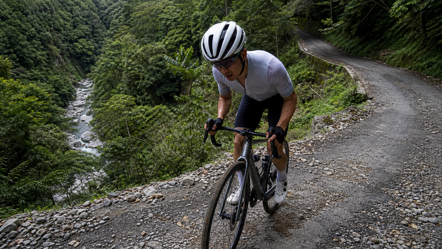
Lileng Creek Forest Road: 4.57 km in length, 378 m of total climbing, 8.3% average grade, difficulty rating 3. The numbers don’t lie—this is a “short but fierce” mountain forest road. It lacks the prolonged agony of a long-distance climb, yet concentrates high-tension pedaling demands into a steep, relentless pitch.
Route Overview and Data Analysis: 378 Meters of Climbing in 4.57 Kilometers
Let’s lay the numbers out first. Lileng Creek Forest Road spans 4,567.12 meters in total length, with 377.8 meters of total climbing, an average grade of 8.3%, and an official difficulty rating of 3 (on a 5-level scale, this sits in the upper-middle range). A quick arithmetic check: 4,567 meters multiplied by 8.3% equals approximately 379 meters, which aligns almost perfectly with the official 377.8-meter figure. This indicates that the route’s grade distribution is relatively “honest”—there’s no extreme structure of gentle-then-steep or steep-then-gentle. While grade variations do exist throughout, the overall emphasis falls within the “sustained mid-to-high intensity climbing” range. This isn’t a route where the average grade on your bike computer deceives you.
Compared to other well-known climbing routes in Taiwan, an 8.3% average grade already enters the realm of “sustained hard climbing.” For reference, the average grade of Yangjin Highway (Yangmingshan–Jinshan) sits around 5%, while the western approach to Wuling fluctuates between roughly 6% and 7% on most sections. Lileng Creek Forest Road, however, manages to push its average grade to 8.3% in under 4.6 kilometers, meaning there are virtually no true “flat recovery sections” along the way. Riders must seriously confront continuous gravitational load from the very start.
Lileng Creek Forest Road is located in the mountainous area around the Guguan and Lileng tribal communities in the upper reaches of the Dajia River, Heping District, Taichung City. The terrain here is quintessential western Central Mountain Range valley topography—the Dajia River cuts through the mountains to form a deep gorge, with tributaries on both sides (including Lileng Creek) flowing down from higher elevations into the main river. Forest roads built along these streams naturally feature steep grades and dense switchbacks. This also explains why Lileng Creek Forest Road, despite being less than 5 kilometers long, is rated at difficulty level 3: the inherent terrain conditions dictate that this route will not be a leisurely scenic ride.
Road surface is a variable that must be seriously considered when planning your trip. Forest roads in central Taiwan’s mountainous areas commonly feature a mix of asphalt and gravel surfaces. Especially after typhoon season or heavy rainfall, sections with damaged roadbeds or repaired landslide areas often have loose gravel covering and uneven surfaces. Before riding Lileng Creek Forest Road, riders are advised to check recent weather conditions and announcements from forestry authorities, avoiding the risk of tackling the route while landslide debris remains uncleared—being forced to turn back midway due to a closed or partially closed road takes a significant toll on both energy and itinerary planning.
From a riding perspective, Lileng Creek Forest Road is better suited as “a high-intensity module within a single-day training plan” rather than a casual recreational option. The short distance means you can complete a solid climbing workout stimulus within a limited time frame; but the steep grade also means that without proper warm-up and pacing strategy, you risk depleting muscle glycogen reserves midway through, leading to slowdowns or even forced dismounts in the latter sections.
Section-by-Section Strategy from Start to Finish: Grade Changes and Pacing Rhythm
Breaking the 4.57 kilometers into several mental and physical checkpoints is the most practical approach to tackling this type of short, steep route. The following sections are strategic recommendations based on the overall 8.3% average grade characteristics, combined with common grade distribution patterns found on Taiwan’s mountain forest roads. Actual mileage markers and grade readings should still be confirmed with real-time GPS data from your bike computer and on-site distance signage.
Section 1 (0–1 km): Warm-up and Probing. The starting section of most mountain forest roads typically doesn’t immediately spike to maximum grade, as both your body and cardiovascular system are still transitioning from flat-road to climbing mode. For this section, ride with a deliberate effort to “keep your heart rate low”—don’t get pulled along by the pace of riders ahead. Keep your heart rate between 75% and 80% of your maximum, giving your body enough buffer to adapt to the continuously rising terrain ahead. Many riders lose out on this route because they misjudge the starting section as not steep enough and push too hard, leaving no reserves when the real steep pitches arrive in the middle section.
Section 2 (1–2.5 km): Entering the Core Steep Zone. This is the section where the route’s 8.3% average grade truly translates into tangible physical sensation. Sustained double-digit instantaneous grades are not uncommon here. For pacing, a mixed approach of “seated as the primary position, standing when necessary” is recommended: prolonged standing sprints on steep slopes can momentarily boost power output, but they also accelerate fatigue accumulation in the quadriceps and cardiovascular system. On a route that’s under 5 kilometers yet demands sustained effort all the way to the finish, discipline in energy distribution matters more than explosive bursts. Maintain a cadence between 70 and 85 rpm in this section to avoid excessive knee joint stress from grinding a heavy gear.
Section 3 (2.5–3.5 km): The Mentally Toughest Mid-to-Late Stretch. Based on experience, what breaks riders on this type of short, high-average-grade route isn’t the grade itself, but the psychological uncertainty of “how much farther.” Lileng Creek Forest Road is 4.57 kilometers long, and by this stage you’ve actually completed more than half. At this point, riders are advised to proactively check the accumulated distance on their bike computer, using concrete numbers to remind themselves that “the finish isn’t far,” avoiding the anxiety of an endless climb that disrupts pacing.
Section 4 (3.5–4.57 km): The Final Sprint Zone. Approaching the final kilometer, if energy has been allocated properly, you can slightly increase output here, finishing the last push at near-threshold heart rate (approximately 88% to 92% of maximum). However, be sure to watch the road surface—the latter sections of mountain forest roads often feature “compound hard points” where corners and grade intensify simultaneously. Over-aggressive sprinting leading to handling errors is a common accident risk, especially on sections transitioning to gravel surfaces where you should ease off the throttle.
Gear Ratio and Equipment Recommendations: Drivetrain Setup for an 8.3% Average Grade
A route with an 8.3% average grade and instantaneous grades potentially reaching double digits has clear drivetrain requirements: prepare a wide-range cassette with light gearing. For road bikes, a rear cassette with at least 32 teeth is recommended (current 11-speed and 12-speed systems generally support this), paired with a compact crankset (50/34T) or even a sub-compact (48/32T) up front. This allows you to maintain a reasonable cadence on sustained steep climbs, preventing knees and cardiovascular system from being forced to grind overly heavy gears.
For gravel bike or knobby-tire users, the mixed asphalt-and-gravel surface of Lileng Creek Forest Road is actually a relatively friendly scenario—wider tires (32c or above recommended) provide better traction and vibration damping, significantly boosting handling confidence on gravel sections, especially during the descent back down.
Regarding wheelsets, this route is not recommended for ultra-lightweight race wheels with insufficient climbing stiffness, as the forest road’s high surface unevenness means durability and vibration resistance matter more than pure weight figures. A mid-tier training wheelset with a reasonable rim depth and spoke count is recommended, balancing climbing efficiency with durability.
For tire pressure, if you’ve confirmed the road includes loose gravel sections, consider dropping pressure by 5 to 10 psi from your usual road tire settings to increase contact patch and comfort. But be careful not to go too low, as this risks pinch flats, particularly at pothole edges or gravel transitions.
For braking, disc brakes are the priority recommendation. Lileng Creek Forest Road’s dense climbing means the return descent will feature correspondingly continuous downhill sections. Disc brakes offer significantly better braking stability on wet or gravel surfaces compared to traditional rim brakes, and are less prone to failure from heat fade during prolonged downhill braking.
Nutrition and Hydration Strategy: The Hidden Trap of Short, High-Intensity Routes
Many riders mistakenly assume that “a short distance means nutrition doesn’t matter” — this is the most common strategic blind spot on routes like Lileng Creek Forest Road. With an average gradient of 8.3% and 378 meters of total climbing, even if the entire ride takes only 20 to 40 minutes to complete (varying greatly by individual ability), the energy expenditure intensity per unit of time is far higher than on long, gradual climbs.
Before the ride: It is recommended to finish a carbohydrate-focused meal or fueling at least 60 to 90 minutes before departure, and ensure your body is fully hydrated. Although there are a few scattered shops around the Lileng Tribe and Guguan area, the forest road itself typically lacks refueling points along the way. Be sure to fill your water bottles and pack portable snacks in Guguan or the Lileng settlement before entering the forest road.
During the ride: Based on an estimated riding time of 20 to 40 minutes over 4.57 kilometers, mid-ride food intake is theoretically not necessary, but hydration remains important — especially since the mountainous areas of central Taiwan are hot and humid in summer, and even short climbs can cause heavy sweating. It is recommended to carry at least one 750ml water bottle, and if temperatures are high, consider bringing electrolyte supplements.
After the ride: The 30 minutes following a steep climb is the golden window for muscle glycogen recovery. It is recommended to consume recovery nutrition with a carbohydrate-to-protein ratio of approximately 3:1 to 4:1, especially if your itinerary involves turning back on the forest road or linking to other segments (such as Basianshan Forest Recreation Area or Songhe Tribe) — the sooner you begin the recovery process, the better.
Since there are virtually no convenience stores or aid stations along the forest road, this route is strongly not recommended for “going ultralight” — better to carry an extra water bottle and an energy gel than to face a shortage of water and food deep in the mountain forest.
Weather and Seasonal Considerations: The Variable Climate of the Guguan Mountain Area
The Guguan area of Heping District, where Lileng Creek Forest Road is located, features typical central Taiwan mountain climate, with significant diurnal and seasonal temperature variations. In summer (June to September), although the lowlands are muggy and hot, mountain temperatures are relatively cooler — however, this is also the high-risk season for typhoons and afternoon thunderstorms. Mountain roads are prone to rockfalls and landslides from heavy rain, so be sure to check the latest road condition announcements from the Directorate General of Highways or forestry authorities before riding.
In winter (December to February), mountain temperatures can drop noticeably, especially with sudden temperature drops in the early morning and evening. Combined with the forest road’s many shaded sections with limited sunlight, the chance of wet, slippery roads and dew formation increases. It is recommended to carry a warm layer and reduce descending speed when visibility or road conditions are poor.
Spring and autumn (March to May, October to November) are generally considered the most comfortable seasonal windows for riding Lileng Creek Forest Road, with moderate temperatures and relatively lower rainfall probability — these are the recommended prime periods for planning this route. Regardless of the season, afternoon fog and sudden visibility drops in the mountains are variables to watch out for. It is recommended to start in the morning whenever possible, avoiding the high-risk time window when mountain weather changes rapidly in the afternoon.
Common Mistakes and DNF Risks: The Three Most Common Errors on Short, Steep Climbs
Mistake 1: Incorrect gear ratio selection — pushing through causes knees to give out early. On a route with an 8.3% average gradient, using overly heavy gearing (such as a standard 53/39T crankset paired with a narrow-range cassette) can easily lead to cadence dropping below 50 rpm mid-climb and a sudden spike in knee stress. Once sharp knee pain appears, the risk of continuing to ride far outweighs the brief time lost by dismounting and walking.
Mistake 1 extension — starting too fast. As mentioned in the segment-by-segment strategy above, many riders misjudge the route’s short total length and sprint off at the start, only to be exhausted by the core steep section (1–2.5 km). The lesson from this route is clear: a short distance does not mean you can approach it with a sprint mentality — on the contrary, it demands even more precise pacing discipline.
Mistake 2: Underestimating the risk of gravel and landslide sections, leading to crashes from handling errors. Forest road surfaces are not as smooth and predictable as urban asphalt. Especially after rain, sections can become muddy, covered with fallen leaves, or strewn with exposed gravel. It is recommended to look 5 to 10 meters ahead while riding, anticipating surface changes in advance to avoid sudden braking or evasive maneuvers that could cause a crash.
Mistake 3: Insufficient water and nutrition preparation. As detailed earlier, this bears repeating — even on a route under 5 kilometers, the combination of hot, humid mountain conditions and sustained high-intensity output means the risk of dehydration and hypoglycemia remains real. Riders with insufficient training volume are especially prone to cramping or sudden energy crashes in the latter half.
DNF (Did Not Finish) on Lileng Creek Forest Road is usually not caused by the distance being too long, but rather by pacing misjudgment, unsuitable gearing, or deteriorating weather and road conditions forcing a turnaround. Proper preparation and on-the-spot judgment are the keys to completing this route.
Target Time References for Riders of Different Levels
The time ranges below are reference estimates based on general fitness correlations for routes with an 8.3% average gradient and 378 meters of total climbing. Actual completion times will vary significantly depending on individual fitness, daily condition, and weather/road conditions. Riders are advised to calibrate using their own historical climbing data (such as FTP wattage performance on similar gradient segments) rather than rigidly applying the numbers below.
| Rider Level | Reference Completion Time | Perceived Intensity |
|---|---|---|
| Advanced / Competitive rider | Approximately 15–20 minutes | Near-threshold intensity, full-effort throughout |
| Upper-intermediate recreational rider | Approximately 20–28 minutes | Medium-high intensity, requires segmented pacing adjustments |
| General recreational rider | Approximately 28–40 minutes | Needs moderate speed reduction and recovery mid-climb |
| Beginner / Lower fitness rider | 40+ minutes, may need to walk | Recommended to progress gradually with a training plan |
It is worth noting that Lileng Creek Forest Road is rated difficulty level 3. For beginners new to mountain climbing training, it is recommended to first build foundational climbing ability on routes with gentler gradients and lower elevation gain, then gradually take on sections with average gradients exceeding 8%, to avoid sports injuries or safety incidents caused by overconfidence.
Training Plan Suggestions: How to Fit Lileng Creek Forest Road into a Periodized Program
For riders with systematic training plans, the greatest value of Lileng Creek Forest Road lies in its “short, steep, repeatable” characteristics, making it ideal as the core unit of an interval climbing workout. Below are several common training approaches for riders with different goals.
Single-effort testing format: Treat Lileng Creek Forest Road as a complete power/heart rate test — ride at full effort, record average wattage, average heart rate, and completion time, then repeat the test every 4 to 6 weeks to track your long-term climbing improvement curve. This approach is particularly suitable for riders preparing for Wuling or other long-distance climbing events, serving as an objective indicator of training effectiveness.
Out-and-back repeat climbing format: If road conditions and traffic around Guguan permit, some riders choose to do multiple out-and-back repeats on the Lileng Creek Forest Road segment — full effort on the climb, easy spinning on the descent for recovery, repeating 2 to 4 times. This training method offers clear benefits for improving anaerobic threshold and lactate tolerance, but be sure to prioritize safety on descents, avoiding handling errors caused by training fatigue.
Linked long-distance format: Incorporate Lileng Creek Forest Road as one challenging segment within a full day of long-distance riding in the Guguan mountain area — for example, combining it with the Central Cross-Island Highway from Guguan to Deji, or routes around Basianshan — to simulate the real-world scenario of having to tackle a hard climb after significant energy has already been expended mid-way through a long climbing event. This approach more closely mirrors actual race conditions, but demands higher fitness and itinerary planning, and is recommended only for riders with a solid climbing foundation.
Regardless of which training format you choose, it is recommended to use objective data tools such as a power meter or heart rate monitor for recording. Relying purely on feel can easily lead to misjudgment due to daily mental state, weather, sleep quality, and other factors. The 4.57-kilometer length and 8.3% average gradient of Lileng Creek Forest Road fall precisely within the ideal duration range of “5 to 20-minute threshold climbs” found in most power-based training plans, making it an excellent training resource.
Safety and Response: Risk Management for Deep Mountain Trail Riding
Riding deep mountain forest roads like the Lileng Creek Trail, risk management is just as important as physical fitness and equipment preparation. First is the communication issue—mountain trails frequently have weak or even no cell phone signal. It is recommended that riders inform family or riding partners of their specific itinerary and expected return time before departure, and try to avoid venturing deep into the trail alone. If conditions permit, riding in a group or at least with two or more people is the most basic safety principle for mountain riding.
Second is emergency equipment preparation. It is recommended to carry a basic tire repair kit (inner tube, patch kit, pump or CO2 cartridge), a multi-tool, and simple first-aid supplies (medical tape, antiseptic wipes, etc.). If a mechanical failure or crash abrasion occurs on a mountain trail, the nearest supply point or medical resource may be quite far away, making self-sufficiency especially important in such situations.
Third is wildlife and environmental factors. The mountain trails in the Taichung area are ecologically rich, and encounters with snakes or other wildlife are possible, especially on sections with dense grass or poor visibility. It is recommended to slow down and stay alert. In addition, temperature variations and sudden weather changes in the mountains (such as the afternoon thunderstorms and fog mentioned earlier) are variables that require constant attention. It is recommended to periodically observe cloud changes in the sky during the ride; if the weather clearly deteriorates, make a decisive decision to turn back rather than stubbornly pushing through the challenge with a hopeful mindset.
Finally, real-time confirmation of trail access status should not be overlooked. Forest roads in central Taiwan’s mountainous areas frequently suffer landslides or debris flows due to typhoons and heavy rain, and some sections may be officially closed by forestry authorities. Before departure, it is recommended to confirm the latest road conditions through public information channels from the Forestry Bureau or the local village office, to avoid wasted trips due to information gaps or even accidentally entering dangerous sections.
Difficulty Comparison with Other Guguan Mountain Routes
Placing the Lileng Creek Trail within the broader landscape of routes around Guguan allows for a more accurate assessment of its training value. Routes on Provincial Highway 8 toward Guguan, such as the ride from Xinshe via Zhongxingling onto Provincial Highway 8, often exceed 80 kilometers in total distance with cumulative elevation gain approaching 1,100 meters. These are long-distance endurance training routes with relatively gentle gradient distribution, emphasizing the ability to sustain steady output over long periods. In contrast, the Lileng Creek Trail packs 378 meters of climbing into less than 5 kilometers, taking a completely different approach—short duration, high intensity, concentrated gradient impact, closer to the logic of interval training rather than endurance riding.
If comparing the Lileng Creek Trail to the approximately 23-kilometer gentle climb section on Provincial Highway 8 leading to Guguan with about 345 meters of elevation gain, the latter averages around 1.5% gradient, with a riding feel closer to “sustained cruising” rather than “hard grinding climbs.” The 8.3% average gradient of the Lileng Creek Trail is an entirely different level of challenge. This comparison also reminds riders that even among “Guguan mountain routes,” the actual training stimulus and difficulty perception can vary dramatically, so be sure to confirm which specific section you intend to tackle when planning your ride.
For riders planning a full-day Guguan mountain itinerary, consider using the Lileng Creek Trail as a “hard point interlude” in the middle of the trip—first warming up and accumulating base mileage on the gentler Provincial Highway 8 section, then inserting the Lileng Creek Trail as a high-intensity interval stimulus, and finally finishing with an easy cool-down ride. This hybrid itinerary design can simultaneously deliver the dual benefits of long-distance endurance training and short, high-intensity training—a worthwhile approach for advanced riders planning a one-day Guguan trip.
Conclusion: Short Distance Does Not Mean Easy—Data Is the Most Honest Coach
With 4.57 kilometers of distance, 378 meters of climbing, and an 8.3% average gradient, the Lileng Creek Trail proves that “short route” and “easy ride” are two completely different things. This route serves as a touchstone for advanced riders to test their climbing ability and pacing discipline, and also works well as a compact, efficient interval climbing module in a training plan. Proper equipment preparation, a solid nutrition strategy, rigorous pacing discipline, and a well-developed risk management mindset are the four most practical keys to completing this route. The next time you plan a riding itinerary in the Guguan mountains, consider adding the Lileng Creek Trail to the menu—use the most honest numbers to test your most genuine ability.
Related Reading
- Lileng Return Ride Strategy: Pacing and Gear Ratio Breakdown of the 7% River Valley Climb on Provincial Highway 8
- Lileng Creek Deep in Guguan: A Trail Ride into the Atayal Tribe and the Memory of the Dajia River
- Guguan Climb Guide: A 4.4 km, 11.7% Average Pure Steep Climb Refinement Textbook
- The Sound of Water in Lileng Village and Baibeng Ice Pops: A Riding Memory in the Arm of the Dajia River
台北闊瀨陡坡 騎旅 / 日本單車雜誌編輯車友臨時加入!/ 髮香才是最強的 / feat. 北迴歸線小隊 / 公路車 CT Yeh
6 個月前
半日 小台灣 極限單車路線挑戰實錄
7 年前
一定要騎一次!阿里山最深處:里佳部落!單車旅行 | 2800m爬升 | 深度部落體驗:嗨翻晚會、螢火蟲、銀河 | feat. JJSC & 廢物伙伴 | 公路車 CT Yeh
9 個月前
藤枝二集團 單車行 Day1 | 南部小武嶺 | 爬坡爬到罵罵叫 | JJSC | 公路車 | CT Yeh
3 年前
#公路車 #西進武嶺 配速配瓦實驗 坡度分析 四小時內攻略 建大盃 NeverStop #西進武嶺攻略
6 年前
#北橫 + #北進武嶺 最硬的員工旅遊 EP1 | #公路車 #拉拉山 | 明池 | 武嶺 | 武陵農場 | 雲海 | Taiwan Cycling Route Wulin
6 年前
爬坡ITT實境)台中 魔王 松鼠坡 首航 6:12 大肚山 大三元 科福路
8 年前
嘉義大埔、阿婆灣挑戰賽,美到以為在日本!ft. 環騎5 Cool 西拉雅188 / 公路車 / CT Yeh
7 個月前