Balaka Highway Guide: 10.2 km Classic Gentle Climb on Yangmingshan, Data Breakdown of the True Difficulty of "The Last Finger of Rulai's Palm"
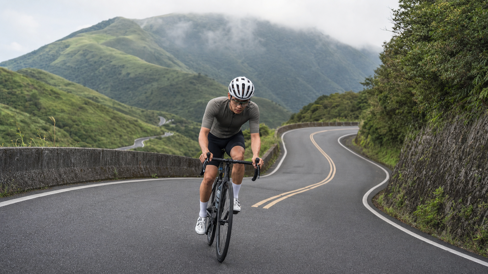
Distance 10.2 km, total elevation gain 917 m, Strava average gradient 5.8%, climb category 3—Balaka Road (County Highway 101甲, connecting Yangmingshan’s Zhuzihu and New Taipei City’s Sanzhi District) is one of the most famous “popular gentle climbs” near Taipei, and the final finger of the “Buddha’s Palm” reverse route passed down by word of mouth among the local cycling community.
This road is famous for two reasons: half for the scenery, half for its “relatively friendly” reputation—compared to climbs on other sides of Yangmingshan like Fengguizui or Neishuangxi, Balaka Road has a wider surface, smoother curves, and the gradient indeed feels more “manageable.” But before writing this guide and laying out the official data for verification, we must honestly confront one thing: the true difficulty of this road may be harder than its “gentle climb” reputation suggests. Below, we let the data speak and break down every aspect of this road.
1. Aligning the Numbers First: Where Does the 5.8% “Gentle Climb” Reputation Come From
The official average gradient for Balaka Road is listed at 5.8%. Taken on its own, this figure does fall into the “moderately gentle” category of climb grading, which is the main basis for its reputation as “one of Taipei’s most popular gentle climbs.” But here’s the problem: multiplying the full length of 10.1975 km by the 5.8% average gradient should theoretically yield a total elevation gain of around 591.5 m, yet the official total elevation gain is listed at 917.0 m—a difference of over 325 m, nearly 55%. This is not a fluctuation within the margin of error; it is a discrepancy that must be honestly flagged.
Conversely, dividing the 917 m total gain by the 10.1975 km distance yields an actual average gradient closer to 9.0%, which no longer qualifies as “gentle climb” territory, but rather falls into the moderately hard climbing range.
This discrepancy may stem from several scenarios: First, Balaka Road itself is not a pure continuous ascent—it includes several short undulations along the way (brief descents followed by re-climbs). GPS devices calculate “total elevation gain” by summing the absolute values of all ascending segments, which pushes the total gain figure well above the simple “net gain from start to finish.” If the “average gradient” field is calculated using net elevation difference, it will significantly understate the road’s true climbing intensity. Second, it may also reflect the presence of steeper sections masked by the average—certain corner sections have gradients far exceeding 5.8%, but because they are flanked by gentler slopes or short flats, the overall average gets pulled down.
Regardless of which root cause applies, we recommend riders approach this road with more caution than the “5.8% gentle climb” impression suggests, especially once you enter the middle and later sections. It does have its “relatively friendly” side—good pavement quality, open sightlines, and gradient changes that aren’t as brutal as some other Yangmingshan routes—but understanding the physical cost of this road through the 917 m of elevation gain will be far closer to the actual suffering of riding it than looking only at the 5.8% figure. This is also the most important stance of this guide: being rideable does not mean being easy.
2. Route Overview and Segment Logic
At 10.2 km in length, the road can be divided into five functional segments for pacing and effort management. The segmentation below follows the typical terrain rhythm of long climbs (initial attack, entering the main ascent, mid-climb challenge zone, recovery gradient, and final summit push), with functional divisions. For actual gradient changes, we still recommend real-time monitoring with your bike computer while riding:
| Distance Range | Functional Role | Recommended Heart Rate Zone | Recommended Cadence |
|---|---|---|---|
| 0~2K | Warm-up start, find your rhythm | Zone 2~3 (65%~80% LTHR) | 85~95rpm |
| 2~4.5K | Entering the main ascent, gradient becomes noticeable | Zone 3~4 (80%~90% LTHR) | 75~90rpm |
| 4.5~7K | Mid-section continuous corners, hardest stretch of the entire route | Zone 4 (88%~95% LTHR) | 65~85rpm |
| 7~8.5K | Brief recovery gradient for a breather | Zone 3 (78%~85% LTHR) | 90~100rpm |
| 8.5~10.2K | Final summit push, wind strengthens near the ridge | Zone 4 (88%~95% LTHR) | 70~85rpm |
The logic behind this pacing plan is straightforward: on a climb of around 10 km, if you push your heart rate to the max from the start, you will inevitably blow up in those three continuous corner sections in the middle. Conversely, if you stay overly conservative the whole way, the final summit push will feel like wasted leftover energy. A 10 km climb truly tests “pace management” rather than single-point explosive power—this is also the most fundamental difference between it and short climbs like the 4 km Xiding Road: short climbs have a large margin for error, while 10 km long climbs have a small one. Once you make a pacing mistake in the early section, the middle section will exact the price immediately.
3. Segment-by-Segment Riding Details: Strategies for Each of the Five Sections
Segment 1 (0~2K): Find your breathing rhythm. Entering Balaka Road from the Zhuzihu direction, the gradient in the opening section is relatively mild—one of the sources of the road’s “gentle climb” reputation. There’s no need to rush the power output here; the goal is to smoothly bring your heart rate from flat-road cruising into Zone 2~3, while also observing the day’s wind direction and road surface conditions—weather in the Yangmingshan area changes far faster than in the city. During this opening section, it’s worth assessing cloud cover and visibility to decide whether you need to adjust your plans.
Segment 2 (2~4.5K): The gradient becomes noticeable—this is where the real warm-up ends. After entering this section, the “gentle climb” illusion from the earlier stretch gradually breaks apart, and the continuous gradient will make most riders first feel their heart rate and breathing noticeably elevate. Here, we recommend actively dropping your cadence to the 75~90rpm range, trading torque for steady output, and avoiding the trap of grinding at too high a cadence that pushes your cardiovascular system into high-load territory prematurely.
Segment 3 (4.5~7K): The hardest continuous corner section of the entire route. This is the section with the greatest gap between Balaka Road’s reputation and its actual feel, and also the most direct evidence explaining the “5.8% vs 9%” contradiction mentioned earlier—multiple riders who have climbed this road report that this stretch of continuous corners indeed contains sections with gradients noticeably steeper than the route average. We recommend adopting a “focus on the corner ahead, don’t look at the summit” strategy, breaking the long distance into small targets at each corner and conquering them one by one, avoiding the psychological collapse that comes from seeing the distance readout and thinking “there’s still so far to go.”
Segment 4 (7~8.5K): A hard-earned recovery gradient. After surviving the mid-section continuous corners, the gradient here drops noticeably—a rare chance to catch your breath on the entire route. We recommend using this stretch to bring your cadence back up to 90~100rpm, allowing lactate to be metabolized, while also doing a quick refuel (see the nutrition section below) to reserve energy for the final summit push.
Segment 5 (8.5~10.2K): The final test before the summit—wind is the key variable. As you approach the ridge and the exit toward Sanzhi, the terrain gradually opens up, and the wind typically strengthens noticeably compared to the forest-enclosed middle sections. Especially during the northeast monsoon season, a headwind on the summit push can stack additional difficulty onto the perceived effort of this final stretch. We recommend reserving at least 10%~15% of your energy buffer for this section, and flexibly adjusting your target pace based on current wind conditions—don’t burn all your reserves in the middle section.
4. Gear Ratio and Equipment Recommendations
Given a route with an average gradient closer to 9% after conversion and potentially steeper sections in the mid-climb continuous corners, road riders using a standard crankset (53/39T) should pair it with at least an 11-30T cassette. Riders of average fitness or those wanting to preserve energy are better off with a compact crankset (50/34T) paired with an 11-32T or 11-34T cassette, allowing you to maintain an effective cadence through the hardest continuous corner sections without being forced to stand and grind, which burns through glycogen excessively. The increasingly popular 1x systems (e.g., a 40T single chainring paired with a 10-36T cassette) are also well suited to this type of long-distance, undulating climb—simplifying shifting decisions and letting the rider focus on pace management.
For tire pressure, adjust based on body weight and the day’s road moisture. A typical 70kg rider can set the front tire at 85~90psi and the rear at 90~95psi; if there has been recent rainfall and the road is damp, drop both by about 5psi for added grip. As for braking systems, the descent on Balaka Road features significant gradient changes, and combined with limited sightlines on mountain corners, we strongly recommend hydraulic disc brakes or well-maintained rim brakes, and developing the habit of feathering the brakes early in the descent to avoid heat fade from continuous braking reducing stopping power.
5. Nutrition and Hydration Strategy: A 10 km Climb Should Not Be Taken Lightly
At 10.2 km with 917 meters of elevation gain, the summit push takes anywhere from 35 minutes to over an hour depending on rider ability. This falls squarely into the distance range where mid-ride fueling genuinely impacts performance—it can no longer be dismissed like a short climb. It is recommended to carry at least one 750 ml bottle before setting off. If the weather is hot, or if you plan to include Balaka Road in a longer multi-climb route such as the “Buddha’s Palm” challenge, it is advisable to bring an extra energy gel or portable snack, scheduled for the fourth segment (the 7–8.5K recovery section with gentler gradients). Use the lull in gradient to complete hydration and electrolyte replenishment, avoiding the need to eat while distracted through the hardest mid-section switchbacks, which could compromise bike handling.
The climate in the Yangmingshan area is far more variable than in the city. Even in summer, afternoon convective cloud systems form quickly in the mountains, and the perceived temperature drops noticeably with altitude. It is recommended to carry a lightweight windproof layer even if you set out under clear skies, to cope with the low temperatures and strong winds that may be present at the summit area.
6. Weather and Seasons: The Microclimate of Yangmingshan Should Not Be Underestimated
Balaka Road sits on the western side of Yangmingshan National Park, characterized by a typical volcanic-terrain subtropical mountain climate. It is influenced year-round by the northeast monsoon, orographic clouds, and afternoon convective showers, with weather that changes far more rapidly than in Taipei’s urban area. During the winter (November to February), when the northeast monsoon prevails, dense fog and drizzle are common in the mountains, and visibility can drop to just a few dozen meters. Combined with the already strong winds on the climb, it is essential to check real-time weather before departing in this season, lower your overall pace targets, and carry sufficient thermal and windproof gear. Spring (March to April) offers relatively stable weather and is one of the most recommended riding windows of the year; the vegetation along the route gradually turns green, making it ideal for rides that incorporate the scenery around Zhuzihu. Afternoon convective showers are extremely common in the Yangmingshan area during summer, so an early morning departure is recommended, along with constant monitoring of real-time radar echoes to avoid the risk of lightning while riding. Autumn (September to October) typically offers the best air quality and visibility of the year, and is also the most suitable season for tackling the multi-climb “Buddha’s Palm” challenge over extended days.
7. Common Mistakes and Risk Assessment
- Being misled by the “gentle climb” reputation and pacing too hard in the early section: This is the most common pacing error on Balaka Road—many riders see route descriptions calling it a “popular gentle climb” and attack the opening section at high intensity, only to fade directly upon entering the hardest continuous switchback section at 4.5–7K, sometimes forced to stop multiple times to catch their breath.
- Underestimating the prolonged load of 917 meters of total elevation gain: A 10 km climb demands sustained energy expenditure, not the kind of short-burst effort that allows quick recovery like a shorter hill. It is recommended to plan your energy allocation based on the actual elevation gain figures (rather than average gradient) in advance.
- Ignoring the wind at the summit area: The closer you get to the ridge-line exit, the stronger the wind typically becomes. Without reserving energy to cope with headwinds, the final stretch can feel particularly grueling.
- Wet roads after rain and limited sightlines through corners: The mid-section’s continuous switchbacks already offer limited sightlines; after rain, with slippery surfaces and accumulated fallen leaves, be sure to brake early on the descent back.
- Holiday traffic and tour buses: Balaka Road is adjacent to Zhuzihu, and on holidays there is often a steady flow of tour buses and private cars heading to local restaurants and calla lily fields. Stay highly alert while riding, especially on corners with poor visibility—keep to the right and anticipate oncoming traffic early.
8. Target Time References for Riders of Different Levels
The following times are for reference only; actual performance will vary with the day’s wind conditions, fitness state, and equipment weight. The wind on the climb, in particular, can significantly affect your time:
| Rider Level | Estimated Completion Time | Average Power Reference (70 kg rider) |
|---|---|---|
| Advanced / Race level | 30–38 minutes | 3.8–4.3 W/kg |
| Intermediate / Consistent trainer | 40–50 minutes | 2.8–3.3 W/kg |
| Beginner / Recreational rider | 55–75 minutes | 1.8–2.3 W/kg |
It is worth noting that, due to the discrepancy between the official average gradient and the actual elevation gain, if you try to extrapolate a target time for Balaka Road based on your completion time on a route with a simpler gradient profile (such as Xiding Road at 4.0% average), you are likely to underestimate the difficulty. It is recommended to use the measured ranges provided in this guide as your baseline, and conservatively aim for the upper end of the range as your target for a first attempt.
9. Balaka Road’s Role in the “Buddha’s Palm” Multi-Climb Challenge
In the common understanding of Taipei’s cycling community, the “Buddha’s Palm” is a challenge route combining several climbs around Yangmingshan, named for the way the road network resembles fingers radiating from a palm. The frequently cited “fingers” include Balaka Road, Fengguizui, Neishuangxi, Pingjing Street, and other roads around Yangmingshan, though different rider communities vary slightly in the exact combination and order of routes—there is no single official version. “Reverse riding” refers to tackling these climbs in the opposite order to the usual direction, and in such a reverse arrangement, Balaka Road is often placed as the climactic “final finger.”
The reason it works well as the finale is partly because its relatively wide, smooth pavement and gradient rhythm still offer a degree of completion feasibility after the previous fingers have drained much of your energy. However, as this guide has repeatedly emphasized, the 917 meters of actual elevation gain is by no means easy. If you schedule it as the final stage of a multi-climb route, be sure to reserve sufficient energy reserves and do not let its “supposedly gentle” reputation lull you into complacency. This is one of the most frequently cited lessons in post-ride reflections from veterans who have completed the “Buddha’s Palm” challenge.
10. Training Periodization: How to Fit Balaka Road into Your Program
For riders preparing for longer challenges—such as a full “Buddha’s Palm” multi-climb route or a long-distance climbing event like Wuling—Balaka Road is an ideal “mid-distance climbing simulation” venue: long enough to genuinely test pacing management and fueling rhythm, yet not requiring a full day’s commitment like Wuling’s 20–30 km climbs. During the base phase, it is recommended to include it in a “tempo ride” session, completing one full ascent at near-race intensity to calibrate your sustained power output in Zone 3–4. In the pre-race taper week, you can reduce intensity and use it simply to familiarize yourself with the route rhythm and confirm equipment setup.
11. Traffic Safety and Road Condition Reminders
Although Balaka Road is a popular cycling route, it is also an open county road with considerable holiday traffic. Especially near the Zhuzihu area, tour buses and private cars frequently pass through during calla lily season or meal times. Always ride as far right as possible and stay alert. The mid-section’s continuous switchbacks offer limited sightlines, so wearing a reflective vest and adding a rear blinker light is recommended to increase visibility. When riding in a group, avoid taking up the full lane width so that vehicles behind can overtake safely. Mountain roads have limited drainage design, and after rain or typhoons, localized potholes, rockfalls, or roadbed erosion can occur. It is advisable to check recent road condition reports through local cycling community groups before riding, and avoid going out for a day or two after extreme weather.
12. Equipment Checklist
Before setting out to challenge Balaka Road, complete the following checks: confirm tire pressure is adjusted according to the day’s temperature and road moisture; confirm the drivetrain shifts smoothly under climbing load, especially the rear derailleur’s ability to handle frequent shifting through the continuous switchbacks; confirm you are carrying at least a 750 ml bottle, with an extra energy gel recommended for longer rides or multi-climb challenges combined with other climbs; carry a lightweight windproof layer for the low temperatures and strong winds at the summit area; confirm sufficient battery charge in your headlight and taillight, especially if you plan a later departure; and confirm your phone is fully charged with offline maps downloaded, as mobile network signals can be unstable in some mountain sections.
13. Summary: Reacquainting Yourself with This “Gentle Climb” Through Honest Data
Balaka Road certainly has every reason to be one of Taipei’s most popular climbing routes—the wide pavement, sweeping corners, open views, and its symbolic role as the finale of the “Buddha’s Palm” multi-climb challenge. But the core message this guide aims to convey is this: do not let the “5.8% gentle climb” label overly reassure you. The 917 meters of actual elevation gain tells us that the true physical cost of this road is closer to a moderately hard climb in the 9% range. The continuous switchbacks in the mid-to-late sections and the wind before the summit are both variables that deserve serious respect.
Use the segment pacing table, gearing recommendations, and fueling rhythm provided in this guide as a starting point, and continuously calibrate them against the data feedback from your own rides. You will find that the charm of Balaka Road lies precisely in this “gap between data and feel”—it teaches riders a crucial lesson: truly reliable pacing decisions should always be built on honest numbers, not on a route’s reputation.
14. Suggested Combined Training Routes with the Nearby Yangmingshan Road Network
If you have already ridden Balaka Road on its own several times and feel confident in your pacing, the next step is to consider linking it with other well-known climbing routes around Yangmingshan to form a more complete training or challenge itinerary. A common approach is to use Fengguizui or Neishuangxi as a warm-up or main course in the first half, then connect to Balaka Road as the finale depending on your energy levels—this also echoes the “Rulai Shenzhang” reverse-riding concept mentioned earlier. This kind of multi-climb route design places far greater demands on your cardiovascular system and muscular endurance than riding a single route alone. It is recommended that you first ensure you can complete the full Balaka Road route solo and comfortably before gradually working it into longer multi-day combined itineraries, so as to avoid taking on an overly demanding multi-finger combination from the start and being forced to abandon midway.
For riders preparing for the Wuling series or other long-distance events in New Taipei City’s mountainous areas, Balaka Road is also well suited for inclusion in simulation training two to three weeks before the race, allowing you to verify whether your pacing strategy and nutrition timing under mid-to-long-distance climbing are appropriate. This is far safer than facing a long climb for the first time on race day itself.
15. A Technical Note on the Official Data
Finally, regarding the discrepancy between the “5.8% average gradient” and the “917 meters of total elevation gain” repeatedly mentioned earlier, here is a brief technical clarification for riders interested in a deeper understanding. When GPS devices and the Strava platform calculate “Elevation Gain,” they typically use a method of cumulatively adding up positive elevation changes segment by segment. In other words, as long as the route contains any section that descends first and then climbs again, the elevation regained after the descent will be counted repeatedly into the total elevation gain figure. Meanwhile, if the “average gradient” field is calculated by dividing the net elevation difference between the start and end points by the horizontal distance, it will not reflect the cumulative effect of these intermediate undulations. This is precisely why a climbing route that appears to be “uphill all the way” can sometimes show a total elevation gain significantly higher than the theoretical value derived by working backward from the average gradient. For riders planning their pacing strategy, the practical advice is this: rather than fixating on the single average-gradient figure, which is easily diluted by intermediate undulations, it is better to refer directly to the total elevation gain and estimated completion time. The energy-expenditure assessment derived this way will be closer to the actual riding experience and will better help you make accurate pacing and nutrition plans.
Related Reading
- Yangmingshan Balaka Road: An Analysis of Taipei’s Backyard Climbing Sanctuary
- The Last Finger of Rulai Shenzhang: A Slow Ride Through Fog on Balaka Road and the Volcanic Memory of Yangmingshan
- Alishan Highway Complete Guide: A 53.57 km, 2,000+ Meter Climb Southern Taiwan Long-Distance Pilgrimage
- Wuzhi Mountain Practical Guide: 10 km, 839 Meters of Climbing—Don’t Be Fooled by the “Average 5.7%”
台北闊瀨陡坡 騎旅 / 日本單車雜誌編輯車友臨時加入!/ 髮香才是最強的 / feat. 北迴歸線小隊 / 公路車 CT Yeh
6 個月前
萬年峽谷! 30% 超激陡坡 里佳部落DAY2 還是很硬! | 公路車 | CT Yeh
3 年前
2024 如來神掌 百人約騎挑戰!feat. 秘境單車社團 / 神人們太可怕 / 全程錄影 x 完整坡度解析 / 公路車 / CT Yeh
2 年前
阿里山塔塔加 兩倍特濃版!全新隧道開通! 進喔!公路車 | CT Yeh
3 年前
半日 小台灣 極限單車路線挑戰實錄
7 年前
爬坡ITT實境)台中 魔王 松鼠坡 首航 6:12 大肚山 大三元 科福路
8 年前
公路車 | 塔塔加驚險員工旅遊 | 還好手腳快沒被抓交替!
5 年前
大禹嶺 到 武嶺牌樓 全程前後實況錄影 | 北進武嶺 | 東進武嶺 | KOM | 訓練台 | 坡度分析 | Taiwan KOM Last 10 km HARD | 公路車
6 年前