Lijia Forest Road Battle Guide: 8.33 km, 960.5 m of Climbing, a Strava Hard-Grade Climb Broken Down Segment by Segment
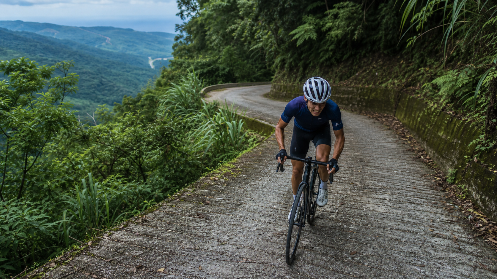
Route Overview: This Isn’t the Full 40 km Lijia Forest Road—It’s the Hardest Section
Let’s get this straight from the start. The Lijia Forest Road is roughly 40 km long in total (some sources say 39 km), an old logging road in Beinan Township, Taitung County, that cuts deep into the Daba Liujiu mountain area. Vehicles are currently allowed up to the yellow gate at the 11.5 km mark; beyond that, it’s walking and cycling territory, with elevation climbing from about 50 m at the base to nearly 1,500 m. If you find claims online like “Lijia Forest Road is an easy ride with gentle gradients,” those almost certainly refer to the lower section or the overall road condition—that’s not the section this article is about.
This guide focuses on the popular segment recorded on Strava (segment ID 11977496)—the essential climbing stretch from the forest road entrance:
| Item | Data |
|---|---|
| Segment Name | Lijia Forest Road (Strava segment) |
| Location | Beinan Township, Taitung County |
| Distance | 8,327.6 m (approx. 8.33 km) |
| Total Elevation Gain | 960.5 m |
| Average Gradient | 8.2% |
| Strava Category | Category 4 (Hard) |
| Strava Segment ID | 11977496 |
8.33 km absorbing 960.5 m of climbing at an 8.2% average gradient—converted into a benchmark familiar to Taiwanese riders, this sits roughly between certain sustained sections of the western approach to Wuling and well-known hard climbs. And because it’s an average of 8.2%, it means the segment must contain steeper stretches to balance out the easier ones; this isn’t the tame type that holds a steady 8.2% all the way to the top. In other words, this is the hardest core section of the full 40 km Lijia Forest Road—not some arbitrarily chosen gentle uphill stretch to pad the numbers, and it doesn’t mean the road ahead after these 8.33 km will be equally hard. But please don’t underestimate the difficulty of these 8.33 km just because “the later section might be easier”—it deserves serious preparation before you ride it.
For local riders in Taitung, the Lijia Forest Road has long been a private secret on the shortlist, less well-known than mainstream routes like Zhiben or Taimali. Precisely because of that, road surface information and rest stop arrangements aren’t as well-developed as on tourist routes. This article will lay out the verifiable physical conditions clearly and handle uncertain areas conservatively, so you don’t head up the mountain with the wrong expectations.
Who This Route Is For
A Strava Category 4 climb means this isn’t a beginner’s route. If you’ve been riding road bikes for less than six months and your training volume is on the low side, I’d recommend building up your strength before attempting it—otherwise you risk ending up in the predicament of “having to push your bike halfway up.” Pushing a bike deep in the forest road is not only exhausting, but resupply is also hard to come by.
A better fit would be: intermediate and above riders who already have experience with well-known long climbs, maintain a solid training intensity base, and know their gear ratio limits clearly. If you’re at that level, the Lijia Forest Road is a hard climb well worth adding to your shortlist—especially since it sees few visitors and has a raw road surface, offering a completely different experience from the touristy, well-known routes. And precisely because it’s off the beaten path, it tests your self-sufficiency even more.
If beginners really want to take it on, I’d suggest riding with experienced companions and setting the goal as “finish safely” rather than “chase a time.” This route’s margin for error isn’t as forgiving as urban training routes. Additionally, I’d recommend finding a training route near home with similar gradient and length for a simulation test, confirming you can pedal continuously for over twenty minutes without stopping, and paying attention to heart rate and breathing changes during the test as a basis for assessing whether you’re truly prepared—rather than relying purely on gut feeling. If you experience significant discomfort during the test, I’d suggest postponing the challenge and first strengthening your base aerobic and muscular conditioning.
Start-to-Finish Section-by-Section Guide
Section 1: Gentle Start at the Entrance—Don’t Be Fooled
Coming in from the Lijia tribe direction toward the forest road entrance, the initial stretch isn’t steep at all, mostly falling between 3% and 5%, with a normal asphalt surface. This section easily lulls riders into complacency—heart rate hasn’t risen yet, gears are still in the middle ring, unaware that the real business is still ahead. I’d suggest treating this stretch as a warm-up, deliberately keeping output low and letting your cardiovascular system and legs get into the groove, rather than rushing to push speed here to prove yourself.
Practical advice: shift into your prepared climbing gear combination early on the gentle entrance slope, letting your body adapt to cadence first, instead of mashing a heavy gear from the start—because sustained double-digit gradient sections are coming soon, and energy management needs to be calculated from here. Many riders fail on routes like this on their first attempt not because they run out of steam in the later sections, but because they misjudge the early going, push too hard, and have already burned through part of their glycogen reserves before the real battle begins.
Section 2: Mid-Section Sustained Steep Climbs—The Real Battlefield
After the gentle start, the gradient climbs noticeably—this is the densest stretch of sustained steep climbing on the entire segment. The 8.2% average figure is mostly generated right here. The defining characteristic: the gradient undulates but rarely flattens out, forcing riders’ heart rates to hover near or even above lactate threshold. Add to that the occasional fallen leaves, gravel, and moisture on the forest road surface, which offer less grip than typical paved mountain roads—cornering and power application both need to be more conservative.
For this section, I’d recommend a strategy of “steady output, no explosive surges.” Many riders, upon entering the steep section and seeing the gradient spike, instinctively stand up and sprint a burst—on an 8.33 km climb with nearly a thousand meters of elevation gain, that’s a fairly dangerous tactic: you’ll likely burn through your glycogen stores before you’re even halfway, leaving you crawling or pushing the bike in the later stages. I’d suggest staying seated as much as possible throughout, keeping heart rate around 85% to 92% of your threshold, building upward at a sustainable rhythm, and saving a bit of perceived fatigue for the steeper sections ahead.
Section 3: Localized Steep Pitches Exceeding 10%—Where Gear Ratios Are Tested Most
Behind a figure like an 8.2% average, there’s almost inevitably a localized steep section exceeding 10% or even approaching double-digit peaks—this is also the key reason the route is classified as a Strava Category 4 hard segment. There’s no precise per-kilometer gradient chart available to cite, but based on experience with similar forest road climbs, riders should expect at least one or two spots in the middle-to-late section that feel like a clear “wall”—the gradient spikes sharply, the front wheel looks like it’s about to lift visually, and cadence drops to extremely low levels in an instant.
The most practical advice for handling these steep pitches: shift down to your lightest prepared gear before you enter the steep section, rather than fumbling with shifts once the gradient has already pressed down on you—especially with electronic shifting, where the chain under high tension can skip or mis-shift on the front derailleur, and mechanical shifting risks rough changes or even chain drops. When you see the road ahead steepen noticeably, shifting two or three pedal strokes early is far more reliable than reacting on the spot.
If you find yourself on a steep pitch with cadence bottoming out and heart rate nearing maximum, rather than grinding until you’re about to blow up—risking cramps or a collapsed position that could lead to a crash—it’s better to pause briefly on a safe shoulder, catch your breath, and set off again. The Lijia Forest Road has low traffic volume and reasonably wide shoulders; this isn’t something to be ashamed of—it’s a rational choice for riding safety and completion rate. One reminder: the forest road is narrow, so when stopping, make sure you’re completely clear of the riding line and watch for other vehicles or cyclists coming from behind.
Section 4: Deep Forest Road Finish—More Mental Battle Than Physical
Approaching the end of the 8.33 km, the gradient typically eases somewhat, but by then riders’ perceived fatigue has accumulated to its peak, making it easy to let your guard down on the seemingly easier stretch and lose your rhythm. In this section, I’d suggest refocusing on breathing and pedaling rhythm, using willpower to push through the final stretch, rather than easing off too early and leaving nothing for the final push.
Deep in the forest road, vegetation is dense and shade is excellent, with temperatures typically a few degrees cooler than at the base—it feels more comfortable, and this is one of the few “gentle” aspects of this route. On the flip side, cell phone signal in the deep forest is often unstable or completely absent—I’ll elaborate on the safety implications of this in the resupply section later. Once you reach the endpoint, I’d suggest finding a spot with an open view and a safe shoulder to stop and catch your breath, looking back at the elevation you’ve just climbed—that sense of accomplishment is usually the most direct reward these hard climbs offer.
Gear Ratio and Equipment Recommendations: An 8.2% Average Grade Is No Joke
With an 8.2% average grade and localized steep sections exceeding 10%, this route is not forgiving when it comes to gear ratio requirements. Here are practical recommendations:
- Crankset: A compact crankset (Compact, 50/34T) is recommended as the baseline setup. If you are heavier or have limited climbing experience, the 34T small chainring is a necessity rather than a luxury—don’t challenge this route with the confidence of “I usually ride a standard crankset and it’s fine.”
- Cassette: At least a 28T starting gear is recommended. If possible, upgrading to a 32T or even 34T large cog (paired with a corresponding long-cage rear derailleur) will make steep climbs easier to pedal, allowing you to maintain a seated pedaling position, reducing the risk of cramps and form breakdown.
- Considering Lighter Gears: If you consider your climbing ability average, or if this is your first time tackling a route with an average grade above 8% and nearly a thousand meters of elevation gain, don’t think of a 34-36T chainring paired with a 28-32T cassette as a “weak setup”—the core purpose of this gear combination is to allow you to stay seated and spin a steady cadence throughout, avoiding premature exhaustion from being forced out of the saddle due to overly heavy gears. In recent years, many manufacturers have also introduced wider-range cassette options; if possible, they are worth evaluating. You could even consider applying mountain-bike-level ultra-low gearing concepts to configure a road bike or gravel bike.
- Wheelset and Tire Width: Forest road surfaces are not as smooth as city roads; leaves and loose gravel occasionally appear. Wider tires are recommended, and tire pressure can be slightly lower than your usual road riding setup to increase grip and comfort while reducing the risk of flats. If your frame allows, a gravel bike or an endurance road bike with wider tires will suit this route better than a pure racing bike with narrow tires.
- Braking System: The descent is another aspect requiring attention. Continuous braking on a long downhill can cause heat fade with rim brakes. If your bike has disc brakes, you’ll be more at ease; rim brake riders are advised to brake intermittently and early, avoiding continuous hard braking that leads to brake fade, especially on wet surfaces where you should leave extra braking distance.
Nutrition and Hydration: No Convenience Stores Deep in the Forest Road—This Is a Firm Reminder
The surrounding area of Lijia Forest Road does have tribal ecotourism activities, such as ecological guided tours and DIY preserved plum making, but these are reservation-based tribal cultural activities, not supply stops where you can buy things on the go along the way. Riders should not expect to encounter shops or water fountains deep in the forest road.
A practical nutrition and hydration strategy:
- Complete your final resupply around Lijia Tribe before departure. Before entering the forest road, make sure you have sufficient water bottle capacity and calorie reserves. The shops or grocery stores at the foot of the mountain are your last safety net; beyond this point, you must rely entirely on what you carry with you to finish the ride.
- Estimate water intake based on temperature and physical exertion. A general recommendation is at least 750 milliliters to 1 liter of fluid per hour. Considering the high-intensity output required by the 8.2% average grade and the humid summer heat of Taitung, actual needs may be higher. It is recommended to carry at least two bottles, or combine with a hydration pack system, to ensure sufficient capacity.
- Don’t wait until you’re hungry to replenish calories. With high climbing intensity, digestive capacity decreases. It is recommended to consume energy gels, bananas, or portable snacks every 30 to 45 minutes. Small, frequent intake is more effective than one large feeding and helps avoid large blood sugar fluctuations that can affect output stability.
- Cell phone signal is often unstable deep in the forest road. This means that in the event of dehydration, cramps, or mechanical failure, outside assistance may be delayed. Be sure to build in generous supply margins—don’t cut your water and calories close to “just enough.” It’s better to carry extra than to run short. It is also recommended to inform family or riding buddies of your itinerary and expected return time before departure.
- If you plan to challenge the full 40-kilometer Lijia Forest Road rather than just this 8.33-kilometer highlight section, your supply planning needs to extend over a longer timeline, because vehicles cannot enter beyond the gate, making logistical support more difficult. Be sure to assess your own ability before deciding to go deeper.
Weather and Seasons: Humid and Muggy Summers, Slippery Conditions After Rain Require Extra Caution
Lijia Forest Road is located in the Beinan mountain area of Taitung, with dense forest cover and rich ecology. This brings two direct impacts on riding:
Humid and muggy summers: Deep in the forest road, humidity is high and air circulation is poor. Even with shade from trees providing some cooling, it still feels hot and stuffy, and you will sweat more than on open sections. This further confirms that the hydration advice in the previous section is not just talk. It is recommended to avoid starting at noon and instead set off in the early morning, which not only avoids the heat but also allows you to tackle this high-intensity climb under cooler conditions, while also avoiding the afternoon convective showers common in mountain areas.
Slippery conditions after rain: Forest road surfaces are not maintained to the same standard as city asphalt. After rain, wet surfaces combined with accumulated leaves significantly reduce grip. Cornering and braking should be done at a slower pace, especially on descents. It is not advisable to tackle this route immediately after rain; it’s safer to wait a day or two for the road to dry out.
Spring and summer butterfly season offers relatively stable road conditions: This forest road is known for its rich ecology, especially in spring and summer when flowering plants along both sides attract large numbers of butterflies. During this season, the weather patterns are relatively stable for this route, and it’s also a great time to enjoy the roadside ecology along the way (for detailed ecological and cultural stories, refer to our other article on the same route’s riding experience). However, even in a relatively stable season, afternoon convective showers in the mountains remain common. Your schedule should still allow flexibility to avoid being deep in the forest road during afternoon thunderstorm hours; it’s best to complete the main climbing sections by late morning.
Autumn and winter are drier but have shorter daylight hours: In autumn and winter, rainfall probability is lower and road surfaces are generally drier and more stable, making it another suitable time to take on the challenge. However, be aware of shorter daylight hours—start early to avoid descending in the dark. There are no streetlights on the forest road, and the risk increases significantly when visibility is poor.
Common Mistakes and DNF Risks: Pitfalls to Avoid
The risk of a DNF (Did Not Finish) on a climbing route often doesn’t come from a single fatal factor, but rather from a domino effect of several small oversights stacking up. Here are some common pitfalls on Lijia Forest Road:
Underestimating the steepness: An 8.2% average grade may not sound like an extreme number, but combined with 960.5 meters of elevation gain concentrated within 8.33 kilometers, plus localized steep sections that may exceed 10%, this intensity is enough to cause unprepared riders to slow down significantly or even dismount mid-way. Be sure to prepare with a “hard level” mindset rather than treating it as a casual weekend training route.
Insufficient water preparation: As mentioned earlier, there are no supply stops deep in the forest road. If you underestimate your water needs, dehydration symptoms (dizziness, cramps, impaired judgment) can set in during the latter half, which is especially dangerous on steep terrain with unstable signal, and could even escalate into a situation requiring external rescue.
Changing forest road conditions: As a former logging road, the surface is not as stable as city roads. Leaves, loose gravel, and occasional potholes can all appear, and maintenance is less frequent than on tourist routes. It is recommended to pay attention to the road’s trajectory before riding, especially on blind corners during climbs—slow down and don’t judge safe cornering distances on forest roads by the speed feel of flat road riding.
Yielding to wildlife: This forest road is ecologically rich, with over 50 recorded bird species, and is also a well-known butterfly-viewing route. Encounters with wildlife crossing the road are possible while riding. When this happens, slow down and yield—don’t disturb the animals just to maintain speed. This is also the most basic respect for this ecological environment, as the area is adjacent to an important wildlife habitat protection zone.
Ignoring escape route planning: Currently, vehicle access is only permitted up to the yellow gate at 11.5 kilometers. If you plan to go deeper beyond this point, be aware that logistical support (such as vehicle pickup or emergency rescue) becomes much more difficult beyond the gate. Make adequate mental preparations and itinerary plans before departure—don’t impulsively go deeper than planned, and don’t push on when your physical condition has clearly deteriorated.
Underestimating descent risks: Many riders focus all their attention on the climb while overlooking that the descent also requires physical strength and concentration. After exhausting your energy on the climb, your reaction speed and muscle control will be diminished on the way down. Combined with the many corners and limited visibility on the forest road, you must restrain your speed on the descent—don’t charge downhill with the mentality of “I worked hard on the climb, so I deserve to have fun on the descent.”
Target Time References for Riders of Different Levels
The time ranges below are estimated based on the reasonable difficulty of a Strava Category 4 climb (8.33 km, 960.5 m elevation gain, 8.2% average gradient). Actual results will vary depending on daily conditions, wind direction, temperature, and individual fitness. These figures are for planning reference only and do not represent any official standard:
| Rider Level | Estimated Completion Time | Average Speed Reference |
|---|---|---|
| Expert (long-term training, strong climbing ability) | Approximately 35–45 minutes | Approximately 11–14 km/h |
| Intermediate Rider (some climbing experience) | Approximately 45–60 minutes | Approximately 8–11 km/h |
| General Enthusiast (moderate fitness, first attempt at a difficult route) | Approximately 60–80 minutes | Approximately 6–8 km/h |
| Conservative Finish (including rest stops, photos, refueling) | 90 minutes or more | Depends on actual number of breaks |
These time ranges are intentionally set wide because, on a route with an 8.2% average gradient and localized steep sections, individual differences are amplified—whether your gear ratios are well-suited, how you feel on the day, and your mental resilience on steep slopes can all lead to significant variations in completion time. Rather than obsessing over “how fast others ride,” it’s better to set your first attempt goal as “safe, injury-free, and successfully completed,” and leave time records to be broken on your second or third attempt after you become familiar with the route. It’s recommended to wear a heart rate monitor or power meter throughout your first attempt; reviewing the data afterward will help you adjust your riding strategy for next time more effectively than simply looking at the clock.
Conclusion: A Private Hard Climb Worth Preparing Seriously For
The popular Strava segment on Lijia Forest Road, with 8.33 km stacking up 960.5 m of elevation gain at an 8.2% average gradient, is one of the few difficult climbs in Taitung that combines both toughness and a raw, unspoiled feel. It is not the entirety of the 40 km Lijia Forest Road, but rather its most solid core section. Approach it with appropriate equipment, gear ratios, supplies, and mental preparation—don’t head out light based on the misconception that “it’s only 8 km.”
Once you’re fully prepared, this route will reward you with more than just a segment record on Strava—it offers a solid physical test and a rare experience of tranquility deep in the forest. For your first attempt, it’s recommended to ride with experienced companions who can look out for each other and offer encouragement during the painful moments of the climb. Wishing you an enjoyable and safe ride, and I look forward to hearing about your experience and insights after you complete it, so more riders can discover this hidden hard climb in Taitung.
Related Reading
- Encountering Butterflies and Tranquility on Lijia Forest Road: A Climb and Cultural Journey Through the Daba Liujiu Mountain Area
- Luye Songlin Practical Guide: How to Ride the Short but Explosive 3.8 km Climb with Steep Sections Exceeding 20%
- Alishan Highway Complete Guide: The 53.57 km Southern Taiwan Epic with Over 2,000 Meters of Elevation Gain
- Pingxi Wufen Mountain Guide: Full Analysis of the Tough 4 km Short Climb in Ruifang with 257 m Elevation Gain and 6.4% Average Gradient
萬年峽谷! 30% 超激陡坡 里佳部落DAY2 還是很硬! | 公路車 | CT Yeh
3 年前
台北闊瀨陡坡 騎旅 / 日本單車雜誌編輯車友臨時加入!/ 髮香才是最強的 / feat. 北迴歸線小隊 / 公路車 CT Yeh
6 個月前
一定要騎一次!阿里山最深處:里佳部落!單車旅行 | 2800m爬升 | 深度部落體驗:嗨翻晚會、螢火蟲、銀河 | feat. JJSC & 廢物伙伴 | 公路車 CT Yeh
9 個月前
里佳部落 阿里山單車深度旅遊! | 竹山/草嶺/來吉/奮起湖 | 無敵銀河絕景 全新路線探索! 驚險狀況百出! | 4K沉浸式畫質 | 公路車 | CT Yeh
3 年前
藤枝二集團 單車行 Day1 | 南部小武嶺 | 爬坡爬到罵罵叫 | JJSC | 公路車 | CT Yeh
3 年前
半日 小台灣 極限單車路線挑戰實錄
7 年前
公路車 爬坡 破PR 紀錄 小技巧 分享
6 年前
嘉義單車路線推薦:碧湖山茶園超陡坡挑戰!里佳部落-奮起湖-瑞峰 (附路線)
7 個月前