A 90-Kilometer Pacific Ride: From Zhonghua Bridge to Balangaw, an East Coast Journey to Rediscover Place Names
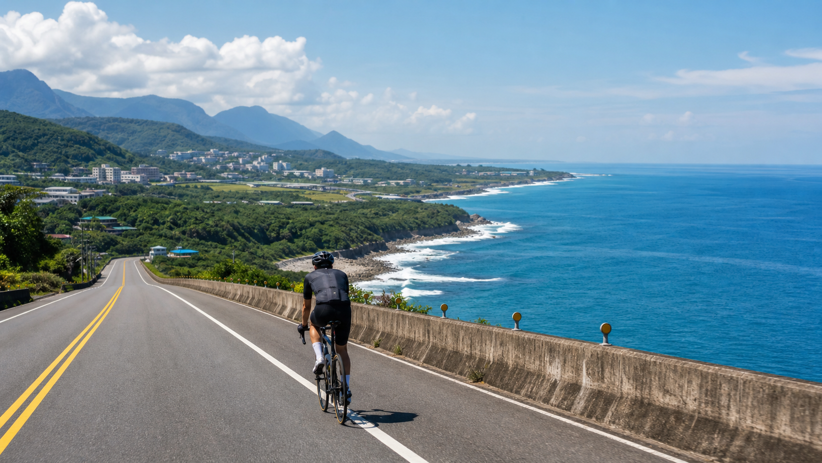
Setting Out from Zhonghua Bridge, First a Word on a Place Name
The moment my wheels roll onto Zhonghua Bridge, I always unconsciously slow down for a few seconds. The bridge deck is straight, the Beinan River flows quietly beneath, and in the distance, the buildings of Taitung City gradually recede into the rearview mirror. The bridge is 1,320 meters long, 13 meters wide, and was opened to traffic on September 20, 1991. It is a section of Provincial Highway 11, connecting downtown Taitung with the Fugang area. For the people of Taitung, this bridge is nothing special—just a place they pass through on the way to work or school every day. But for someone about to ride 90 kilometers of coastal highway, that minute crossing the bridge feels like a ritual—a formal switch from the rhythm of the city to the rhythm of the Pacific.
Before setting out, I like to think through the history of the route. Provincial Highway 11, this coastal road, is one of the most important transportation arteries in eastern Taiwan. Running along the Pacific coast, it strings together countless Amis tribes and fishing villages. It is not a scenic tourist road built for views; it is a road that genuinely carries the transport functions of daily life—it just happens that the scenery along the way is so beautiful that outsiders can’t help but want to ride it all day.
And the endpoint of this route, Bawengweng, holds a story that is easily misunderstood. Many people, upon first hearing the name, instinctively assume it’s somewhere near Luye, since the word “wengweng” has a somewhat rustic, mountainous ring to it. But in fact, Bawengweng is located in the Fengtian Community of Chenggong Township, Taitung County, and is the northernmost settlement of Xinyi Village. Its old name derives from the traditional Amis place name “Bawengweng-she,” which was transliterated into “Bawengweng” after the war. Later, the official place name was formally changed to “Fengtian”—but locals and cyclists familiar with the route still habitually use the old name, because the local bike path, about 3.5 kilometers long, has been preserved under the name “Bawengweng” to this day.
I love this state of “the old name never dying.” The map says Fengtian, and the road signs may also say Fengtian, but among the cycling community and local elders, the name Bawengweng continues to circulate, like a gentle resistance to the erasure of the land’s memory. This ride, in a sense, is also a journey to trace the origins of a place name—from the bridge in the city, riding toward a coastal settlement that retains its old Amis name, spanning not just 90 kilometers of distance, but also a stretch of the development history of Taiwan’s east coast.
The Story of Highway 11: The Making of a Coastal Road
To understand the weight of this ride, you first need to understand Highway 11 itself. It is the primary highway system on Taiwan’s east coast, running from Hualien in the north to Taitung in the south, winding tightly along the Pacific shoreline. The existence of this road allowed the east coast settlements, hemmed in by the Central Mountain Range and the Coastal Mountain Range and relatively cut off from the outside world, to connect with the rest of the island.
Riding along this road, you’ll find the landscape constantly shifting: one moment it’s rugged sea-eroded rock formations, the next it’s an open sandy bay, and then it cuts through low hills and betel nut groves. This diversity of landscape is precisely what makes Highway 11 so captivating—it doesn’t stretch monotonously like western highways, but instead tells different topographical stories along the undulating coastline.
Riding this road, I often think about what this coast used to look like. Before the highway was fully paved, travel between east coast settlements relied on more primitive trails and sea routes. The gradual opening of Highway 11 rewrote the way of life across the entire east coast to some extent—travel between settlements became easier, goods could circulate, but it also meant this relatively isolated land, which had preserved a more complete indigenous culture, began to sync with the rhythms of the outside world. This tension between “development” and “preservation” can still be faintly felt in the settlement landscapes along the route.
For cyclists, the most precious thing about this road is that it still maintains a relatively unhurried traffic rhythm. Unlike the heavy truck traffic and industrial landscapes common on western coastal highways, most sections of Highway 11 remain a tapestry of ocean views, tribes, rice paddies, and the occasional small grocery store. This “slowness” is precisely the most captivating undertone of this 90-kilometer journey.
The Odd Rocks of Xiaoyeliu, the Wind of Jialulan
About a dozen kilometers out of downtown Taitung, you reach Xiaoyeliu. The first time I saw the strange rock formations here, I almost couldn’t help but stop—the tofu rocks, mushroom rocks, and trace fossils carved by marine erosion over countless years are scattered along the shore, like a sculpture exhibition casually arranged by nature. The geological landscape here bears some resemblance to the terrain of Yehliu in the north, hence the name “Xiaoyeliu” (Little Yehliu), but without Yehliu’s tourist crowds, it has more of the east coast’s characteristic openness and tranquility.
Riding further on, the installation artworks at Jialulan Recreation Area come into view one by one. This was originally the site of the Air Force Jianye New Village, and after renovation, it became an open space displaying driftwood installation art. I remember once riding through here just as the sun was setting; golden light spilled over those driftwood sculptures, casting long shadows, while the sound of waves rhythmically lapped the shore—at that moment, I stopped, put my foot down, and just watched quietly for a long while. This kind of unannounced beauty is one of the most precious rewards of cycling; you never know what kind of light and scene you’ll encounter around the next bend.
The wind around Jialulan also has a strong presence. The terrain here is somewhat open, with almost no shelter to block the sea breeze, which often rushes in with a salty tang. Experienced cyclists will tell you that the crosswind challenge in this area is, in some ways, more draining than the gradients themselves—you constantly have to adjust your body’s center of gravity to counter the wind that keeps shifting angles. But it’s precisely this sense of dancing with the wind that makes this stretch feel genuinely “by the sea,” rather than just riding while looking at the ocean.
Continuing north, Shanyuan Beach unfolds into a broad stretch of sand and azure water. This is one of Taitung’s famous beaches, where people often swim and surf in summer. Looking from the highway toward the coast, that blue seems almost borderless—the blue of the Pacific and the blue of the sky merge into a single line in the distance. This image of “sea and sky as one line” is the most classic visual memory of the east coast in summer.
The Oddity of Water Flowing Uphill and the Old Times of Donghe
Riding further north, you pass through the Duli and Donghe area, where “Water Flowing Uphill” is the most intriguing stop on this route. It’s a marvel created by terrain and visual illusion—the water appears to defy gravity and flow upward, but it’s actually a visual misjudgment caused by the slope differential of the surrounding terrain. Every time I ride here, I get off and walk a short stretch, letting my eyes “deceive” me once again. That feeling of knowing it’s an illusion yet still finding it wondrous is one of the few passages on this journey that calls for getting off the bike to savor.
Around Donghe, the old bridge spans the Mawuku River and is one of the more historically resonant spots on this coastal highway. The piers and structure of the old bridge bear the mottled marks of age, forming an interesting contrast with the new bridge beside it—one old, one new, like a microcosm of this coastal road’s development history. I like to slow down slightly when passing the old Donghe Bridge, imagining what the pace of life on the east coast must have been like in the days before the new bridge, when the old one was the only link across the river.
This area is also where you feel the east coast’s “slow living” rhythm most intensely. Occasionally you’ll see local residents lounging in the shade under their arcades, chatting, with time seeming to stretch out especially long. The “hurry up” anxiety of city life finds almost no foothold here. As a cyclist who lives long-term in the city, every time I ride this stretch, I unconsciously ease my cadence—not because I’m running low on energy, but because my state of mind has been assimilated by the rhythm of this land.
Continuing north toward the turnaround point, you pass through several small Amis settlements. Low houses, vegetable gardens, and the occasional drying fishing net form a humble picture of east coast life. These settlements make no deliberate effort to create a tourist atmosphere; they present the most authentic face of daily life—this is one of the reasons I particularly treasure this route; it allows cyclists a glimpse of the most genuine texture of life on Taiwan’s east coast, rather than just packaged tourist scenery.
Pacific Escort: The Rhythm of 90 Kilometers
The most captivating and most demanding aspect of long-distance cycling is that it forces you to confront a special sense of time. Ninety kilometers isn’t short, especially when riding on stretches where you can see the sea almost the entire way—that feeling of “the ocean is always there” gradually changes how you perceive distance and time.
In the early stretch from Zhonghua Bridge, your body still carries the excitement of departure, and your cadence is natural and light. Passing through the undulating sections of Xiaoyeliu and Jialulan, your attention is constantly drawn by the scenery and wind along the way, and time seems to pass especially quickly. But once you enter the relatively straight and monotonous long cruise from Water Flowing Uphill to Donghe, your body begins to enter a near-meditative state—cadence, breathing, the sound of waves, the wind, all gradually merge into a steady rhythm, and your thoughts become remarkably clear amid this repetitive motion.
I’ve always felt that the most precious gain from long-distance cycling is often not the sense of accomplishment at reaching the finish, but this process of being on the road, enveloped by a single, regular rhythm. The Pacific quietly accompanies you on the right side (or the left, depending on outbound or return), the sound of waves drawing near and far with the terrain, and occasionally a sea breeze with its salty tang rushes in, pulling you back from drifting thoughts into the physical present. This dual state of “the body moving while the mind can settle” is perhaps the core reason many people choose long-distance cycling as a way to decompress.
During rides, I often recall a piece of advice a senior cyclist gave me when I first got into long-distance cycling: short rides test your explosive power, but long rides test your ability to coexist with yourself. Ninety kilometers is neither long nor short—it falls right in a distance range that requires both physical reserves and ample time for the mind to settle. The excitement of the early stretch, the focus of the middle, the fatigue and persistence of the later stretch—these form a complete emotional curve, and this curve is, in a sense, a microcosm of how one’s inner state shifts when facing long-term goals. When the wind blows in from the sea, rhythmically striking your face, that repetitiveness becomes a stabilizing force, giving scattered thoughts a frequency to cling to.
When I reach the Bawengweng turnaround point, that feeling of “finally here” is mixed with the complex emotions of the return ride ahead. The coastline still extends northward, and I know I’m about to turn my handlebars around and face the winds and road conditions I came through. This ritual of turning back is, in a way, a metaphor for life—we rarely truly arrive at an absolute endpoint; more often, we reach a milestone, reconfirm our direction, and continue forward. I like to pause at the turnaround point, not rushing to turn around immediately, but finding an angle overlooking the sea and watching quietly for a few minutes. This ocean has been accompanying me since I set out from Zhonghua Bridge; ninety kilometers later, it remains as vast as ever, as if reminding the cyclist that no matter how far you’ve ridden, this Pacific before you is always more enduring than any individual’s fatigue.
The Cultural Depth of Amis Settlements
The Chenggong Township area where Bawengweng is located is one of the important Amis settlement regions. The Amis are the most populous of Taiwan’s indigenous peoples, primarily distributed across the Huatung Valley and the east coast, with a rich maritime culture and traditions of seasonal rituals, the most widely known being the annual summer Harvest Festival (Ilisin). Although it’s rare for an ordinary cyclist to happen upon a tribal ceremony, the traces of daily life visible throughout the settlements along the way—drying fishing gear, architectural elements of traditional houses, the presence of tribal meeting houses—all silently speak to the profound cultural roots of this land.
Traditional Amis life is closely tied to the ocean and rivers; fishing, gathering, and farming form the basic fabric of tribal life. And the place name “Bawengweng” itself is living testimony to this cultural connection—even as the official name has changed several times, locals and the cycling community still choose to preserve this old name that carries tribal memory. This insistence on language and place names is, in a sense, a practice of cultural preservation.
As an outsider cyclist, I always remind myself that this land is not just scenery and a sports venue, but a living cultural space. Slowing down when passing through tribes, maintaining respect for local life, and not casually disturbing residents’ daily routines are basic qualities every cyclist visiting the east coast should possess. What makes this route special is not only its beautiful geography, but also the fact that what it connects is an entire living thread of indigenous culture.
On one ride, I paused briefly before an unremarkable tribal meeting house by the roadside. There was no ceremony taking place; the meeting house stood quietly, but the sense of solemnity emanating from the space itself made me unconsciously soften my steps. Later, after looking up some information, I understood that Amis tribal organization has long been known for its age-grade system (Kaput), and the meeting house is precisely the important venue where young people learn tribal norms and inherit cultural knowledge. This system, having weathered the changes of time, still continues in some tribes—a concrete manifestation of the resilience of Taiwan’s indigenous cultures. When cycling past these places, they may seem like just a few seconds of scenery, but if you’re willing to invest a bit more thought in understanding the context behind them, the meaning of this journey becomes much richer—it’s no longer just a physical workout, but a walk close to the land and the memory of its peoples.
What This Route Means to Cyclists
For the cycling community that has long followed triathlon and long-distance endurance sports, this route has long surpassed the positioning of a mere “scenic route” and become a spiritual landmark. Its distance, terrain, and geographic location naturally create a high degree of overlap with the bike course of the east coast’s most representative triathlon event—Challenge Taiwan. Many athletes preparing for such events will make a special trip to Taitung to ride this coastal highway in person, not just for physical training, but to familiarize themselves in advance with the wind conditions, road surface, and psychological rhythm they may face on race day.
But even setting aside the functional significance of race preparation, this route itself has long been recognized by Taiwan’s cycling world as one of the “classic east coast long-distance routes.” It doesn’t require tackling extreme climbs, yet through 90 kilometers of distance and the coastal highway’s characteristic wind conditions, it tests a cyclist’s mastery of long-duration endurance management. This quality of “seemingly gentle, actually demanding” makes it attractive to both recreational long-distance riders and competitive athletes—the former come for the scenery and mental clarity, the latter for solid physical training; two entirely different motivations find common meaning on the same road.
I myself revisit this route every so often, and each time the experience is different—the wind direction, the season, and my physical and mental state on that day all differ; even on the same road, it feels like riding out different stories. This is perhaps why classic routes are “classic”: they are simple enough that the rider’s inner state becomes the greatest variable in the riding experience; yet they have enough substance to warrant repeated visits and repeated savoring.
Seasonal Coastal Scenery
Visiting this route in summer, the most unforgettable thing is that almost extravagant azure. On clear, cloudless days, the blue of the Pacific and the blue of the sky nearly merge into one, especially on the most open stretches around Shanyuan Beach, where that image of “sea and sky as one line” is enough to make you temporarily forget the fatigue of a long ride. The summer sun on the east coast is intense, and sunlight reflecting off the sea creates shimmering ripples, accompanied by gusts of sea breeze, forming a typical Austronesian summer impression.
The east coast during the northeast monsoon season (roughly November through February) presents an entirely different face. Strong monsoon winds push the waves high and urgent, striking the shore with noticeably more force than in summer; the sky often carries layered cloud systems, and the light becomes colder and sharper. While riding in this season presents greater wind resistance challenges, that vast, desolate coastal vista has its own magnificent beauty—white spray from waves crashing against rocks, set against the gray-blue sea and sky, is another seasonal scenery of the east coast worth savoring.
I personally prefer visiting this route in early winter, when the northeast monsoon has just begun to strengthen but hasn’t yet reached its peak. At that time, the waves already carry a distinct seasonal force, yet the weather remains pleasant and comfortable—not as scorching as midsummer, nor with winds so fierce that riding becomes excessively arduous. This seasonal gap between two extremes is often the most balanced time for a long east coast ride.
Side Trip Suggestions: Making the Journey Beyond Riding More Complete
If time permits, consider turning this ride into a more complete east coast mini-trip. The Dulan Sugar Factory area has transformed into an art colony in recent years; the old sugar mill buildings have been preserved and converted into art spaces and studios, often hosting markets and art exhibitions on weekends. It’s a great place to arrange a leisurely stroll before or after the ride, experiencing the unique atmosphere where industrial heritage and contemporary art blend.
The traditional food in the Donghe area is also a taste many cyclists deliberately stop to sample along the way—the locally famous bun shop often has a queue of people; the soft, fluffy buns with hearty fillings are an excellent choice for replenishing energy on a long ride. However, it’s advisable to check business hours in advance to avoid arriving to find it closed.
Besides serving as a rest stop during the ride, the Jialulan Recreation Area is also an excellent spot for photography, especially at sunset, when the driftwood installation art paired with a golden sky forms an image quintessentially characteristic of the east coast—worth lingering over for some extra time to shoot.
And after returning to downtown Taitung, the Tiehua Village area (although the main venue for Challenge Taiwan moved to Taitung County Stadium in 2025) still retains a strong atmosphere of local music and markets, making it a fitting final stop to unwind and experience the pace of Taitung’s nightlife after a full day of coastal riding.
After completing this 90-kilometer coastal highway ride and looking back on the entire day, you’ll find that what this route gives cyclists goes far beyond physical training. It is a journey spanning geography, history, culture, and personal states of mind—setting out from Zhonghua Bridge, passing strange sea-eroded rock formations, installation art settlements, visual illusion marvels, and traditional Amis settlements, finally arriving at a coastal community that preserves an old place name. This layered thickness of experience is precisely why this stretch of Highway 11 along the coast is worth revisiting again and again for Taiwan’s cyclists.
Related Reading
- Zhonghua Bridge to Bawengweng Turnaround Practical Guide: Full Analysis of the 90km East Coast Ironman Segment
- Taitung Coastal Highway Cycling: The Most Beautiful Riding Scenery on the East Coast
- Huatung Coastal Highway 11: Complete Guide to 180km of Pacific Escort Riding
- Hualien Coastal Highway Cycling Journal: Blue Seas, Blue Skies, and Tribal Charm on Highway 11
嘉義大埔、阿婆灣挑戰賽,美到以為在日本!ft. 環騎5 Cool 西拉雅188 / 公路車 / CT Yeh
7 個月前
台北闊瀨陡坡 騎旅 / 日本單車雜誌編輯車友臨時加入!/ 髮香才是最強的 / feat. 北迴歸線小隊 / 公路車 CT Yeh
6 個月前
大武山20%魔王陡坡【JJSC南台灣遊騎Day2】!屁股真的要裂開了...凡士林抹滿也沒用?神秘金教堂還有超便宜夜市
3 個月前
藤枝二集團 單車行 Day1 | 南部小武嶺 | 爬坡爬到罵罵叫 | JJSC | 公路車 | CT Yeh
3 年前
爬坡ITT實境)台中 魔王 松鼠坡 首航 6:12 大肚山 大三元 科福路
8 年前
台北大雁西飛 約騎挑戰 feat. Doris | 公路車 | CT Yeh
3 年前
水金九不厭五分 10度寒流冷到不願停!feat. 卡卡 / 公路車 / CT Yeh
6 個月前
2025 海鷗團體繞圈賽 / 前八強賽事精華!/ 環台賽等級拍攝 / 國手菁英隊伍較勁 / CT Yeh #公路車
8 個月前