Beidawu Gate Practical Guide: Southern Taiwan's Tough Climb in Pingtung — 10.56K, 677m Elevation Gain, Full Data Analysis
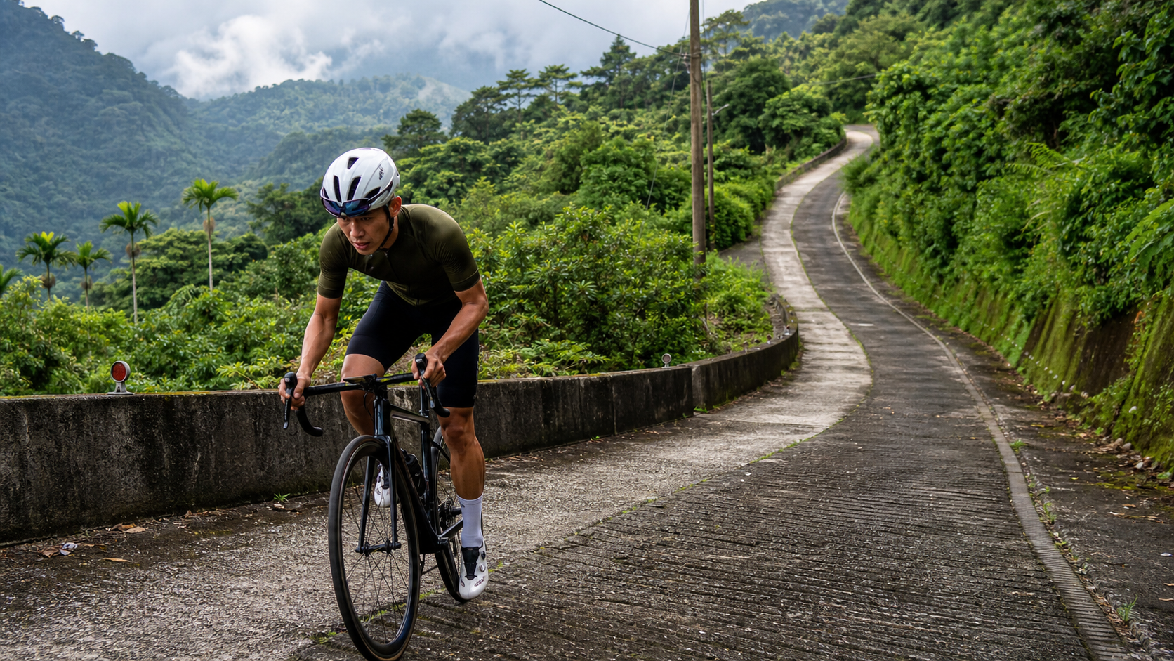
Practical Guide to Beidawu Gate: Full Data Analysis of Southern Taiwan’s Tough Climb—10.56K, 677m Elevation Gain in Pingtung
Average 6.4%, total length 10.56 km, 677 m of climbing—these numbers look ordinary on paper, but when you add the three variables of “southern Taiwan’s humid heat,” “inconsistent road surface quality on the industrial access road,” and “scarce resupply options” into the equation, it becomes a route far tougher than the surface numbers suggest. This article takes an engineer’s approach, breaking down Beidawu Gate from start to finish.
Route Overview and Real Data Analysis
Beidawu Gate (Strava segment ID 19894846) is located in Pingtung County, on the road section leading toward the Beidawu Mountain trailhead. Its official classification is Category 4, a relatively light tier in Strava’s climbing categorization system. But “light” is relative to Tour de France-level HC (Hors Catégorie) or Category 1 climbs—for weekend riders who don’t train heavily, the intensity of this route should absolutely not be underestimated.
Let’s lay out the three core numbers first:
| Item | Data |
|---|---|
| Total Distance | 10,564 m (10.56 km) |
| Total Elevation Gain | 677 m |
| Average Gradient | 6.4% |
| Classification | Category 4 |
| Location | Pingtung County (toward Taiwu Township) |
Let’s do a quick physics check: 10.56 km multiplied by a 6.4% average gradient gives a theoretical elevation gain of about 676 m, which almost exactly matches the official 677 m figure. This means the gradient data for this route is solid—no GPS elevation drift or route double-counting issues. This is an important prerequisite for planning your pacing strategy: you can confidently treat 6.4% as the route’s “baseline truth” for estimating power and heart rate, without needing to discount it further.
However, the “average 6.4%” figure is itself a trap. On Taiwan’s climbing routes, the average gradient is often the result of mixing “gentle sections” with “steep sections,” and you’ll rarely encounter a uniform 6.4% throughout the entire ride—it’s usually gentle at the front, steep in the middle, and gentle again at the back, or the reverse. Beidawu Gate sits in the transition zone from the hilly terrain of the southern Central Mountain Range into the mountainous area. The terrain itself is irregular, and since this is a connecting industrial road rather than a purpose-built climbing route, the gradient changes will be more dramatic than you might expect. Be mentally prepared before riding: some sections may hit instantaneous gradients of 10% or even higher, while other sections will offer near-flat or even brief downhill respites.
From a power perspective, taking a rider weighing 70 kg with a bike and gear totaling about 9 kg (79 kg combined) as an example: to climb the entire route at a 6.4% average gradient and 12 km/h, the sustained power output required would be approximately 200–230 watts (fluctuating based on aerodynamic drag and rolling resistance coefficients). This corresponds to a rider with an FTP (Functional Threshold Power) of 230–260 watts, riding at roughly 85–90% of threshold—a classic “Tempo to Threshold” long-climb intensity zone. If your FTP is below 200 watts, this route will push you close to your anaerobic threshold, and you may even need to intermittently stand and sprint to maintain speed. This significantly accelerates fatigue accumulation and is one of the main causes of blowing up in the latter half and DNF (Did Not Finish).
One often-overlooked detail: at just 10.56 km in total length, this is a short-to-medium climb, which means the penalties for “insufficient warm-up” and “starting too fast” are amplified. A long climb (say, 20 km or more) allows you to start conservatively and gradually find your rhythm, but 10.56 km leaves almost no room for error—if you ride the first 3 km too hard, lactate buildup will leave you exhausted before you even see the finish. This is also why the next section breaks the entire route down segment by segment.
Segment Guide: Elevation Changes from the Start to the Gate of Beidawu
Although publicly available gradient data for this segment is limited, based on the common terrain logic of access roads leading to mid-to-low elevation trailheads in Taiwan, as well as the topographic characteristics of the transition zone from hills to mountains along the route through Wanan and Taiwu, we can conceptually divide this 10.56 km route into four stages to give you a mental framework while riding. Actual gradient changes should still be based on real-time readings from your bike computer and on-site road conditions.
Stage 1 (approx. 0-2.5 km): Warm-up Gentle Slope Section
Most access roads to trailheads in Taiwan feature a relatively gentle lead-in section when entering the climbing portion, allowing riders’ cardiovascular systems and muscles to gradually transition from flat-road riding mode to climbing mode. For this section, it is recommended to maintain an intensity slightly below your target pace, keeping heart rate between Zone 2 and Zone 3 (approximately 70-80% of max heart rate). Do not push all the way into Zone 4 or above just because it feels “still easy”—this is the stage where the route’s difficulty is most easily misjudged, and it is where most riders make their pacing mistakes. Although the gradient here is gentle, it forms the psychological foundation that determines whether you can successfully complete the subsequent three stages—an overly fast warm-up pace will push your heart rate and breathing into the high-intensity zone too early, leaving your body with no reserve when the real challenge arrives.
Stage 2 (approx. 2.5-6 km): Main Climbing Section
This is the most demanding core section of the entire route, with gradients likely exceeding the average of 6.4%, and some continuous stretches potentially reaching 8-10% or even higher. This section begins to test your pedaling efficiency and gear selection, and it is also the zone where heart rate will be pushed toward Zone 4 (near lactate threshold). It is recommended to adopt a “seated-dominant approach with intermittent standing sprints to shift muscle groups” during this section, avoiding prolonged standing climbs that cause heart rate to spike prematurely. If you are equipped with a power meter, this section should be where your power output is closest to your FTP throughout the entire ride, with a target of maintaining 85-95% FTP—do not surge above 100% from the start, or you will struggle to make it to the finish. This section also tests mental toughness the most; the gradient is continuous and unrelenting, easily triggering anxiety about “how much longer.” It is recommended to use the remaining distance display on your bike computer, focusing on “the next kilometer” rather than “the finish line of the entire route,” using goal segmentation to reduce psychological burden.
Stage 3 (approx. 6-8.5 km): Rolling Terrain and Local Steep Sections
After the main climbing section, the route may feature brief rolling terrain—this is also a common characteristic of the transition from hills to mountainous terrain, with several “false flats” that make you think the finish is near, only to be followed by another steep ascent. Be mentally prepared: this rolling section is the most prone to pacing chaos, as your body alternates between “catching a brief breath” and “immediately exerting force again,” disrupting lactate metabolism efficiency. It is recommended to switch to rate of perceived exertion (RPE) rather than staring at power numbers, allowing your body to naturally find a rhythm between recovering on short descents and pressing on short climbs. This stage is also where the view gradually opens up; as altitude increases, looking back along the route reveals the layered terrain of the Wanan Plain and surrounding hills. Taking a moment to lift your head and enjoy the scenery can also help divert attention from muscle soreness.
Stage 4 (approx. 8.5-10.56 km): Final Climb to the Gate of Beidawu
This final section is typically the critical zone of dual physical and psychological testing—your body has accumulated considerable fatigue, but the finish is in sight, and many riders make the mistake of “sprinting too early” here, causing them to run out of steam and slow down in the last 500 meters, ironically extending their completion time. It is recommended to reserve 10-15% power margin in the final kilometer to ensure you can cross the finish line with strength rather than crawling to the end. The gradient in this section may still vary unpredictably; do not relax your focus just because you see the finish landmark. Some riders are caught off guard by a final corner or a sudden steep pitch, causing cadence to plummet or forcing an emergency shift to the easiest gear.
Upon arriving at the “Gate of Beidawu,” this is an important landmark and rest point at the traditional trailhead, and a well-known spot where hikers gather for tea and conversation—for cyclists, this is the endpoint of this Strava segment. Please note: this is not the 3,092-meter summit of Beidawu Mountain. Continuing from the Gate of Beidawu to the summit of Beidawu requires switching to hiking mode, passing through the Kuigu Lodge and Dawu Shrine along the way, eventually reaching the summit—a trail of approximately 9 km with an elevation gain of about 1,549 meters. This is a challenge of an entirely different magnitude, requiring professional hiking gear and at least a two-day, one-night itinerary, and is beyond the scope of cycling. After completing the climb to the Gate of Beidawu, it is recommended to rest and take photos here before descending back on the return leg.
Gear Ratio and Equipment Recommendations
Facing a route with an average gradient of 6.4% and local sections potentially reaching double digits, gear ratio configuration is the key factor determining whether you “climb with ease” or “struggle in agony.” Below are specific recommendations based on different bike types and ability levels:
Road Cyclists: If you are using a traditional 53/39 crankset paired with an 11-25 or 11-28 cassette, this route will be quite demanding for most amateur riders, especially in the main climbing section (Stage 2) and the final section (Stage 4), where standing grinds may become necessary. It is strongly recommended to equip at least a compact crank (50/34T) paired with an 11-32T or 11-34T cassette. This gear combination allows you to maintain a steady cadence in a seated position (recommended 80-90 rpm), significantly slowing the rate of localized quadriceps fatigue. In recent years, many road bikes come standard with wider cassette ranges (e.g., 11-34T or even larger), which is a very rider-friendly configuration for non-professionals, allowing you to retain sufficient spinning room for aerobic efficiency when starting on steep slopes or during continuous climbs, rather than prematurely shifting into anaerobic mode.
Mountain Bike/Gravel Riders: Since some sections around the Gate of Beidawu are industrial roads, the surface may feature potholes, fallen leaves, gravel, or even locally slippery patches. If you are tackling this route on a mountain bike or gravel bike, it is recommended to use a 1x drivetrain with a wide-range cassette (e.g., 10-50T or 10-52T). While this configuration is slightly less efficient on flat roads compared to a road bike’s double-chainring system, it offers greater composure when dealing with uneven surfaces and steep starts—especially in situations requiring a temporary stop and restart (e.g., passing oncoming vehicles, avoiding falling rocks, or yielding to pedestrians). The ultra-light gears provided by a wide-range cassette significantly reduce knee joint strain when restarting.
E-Bike Riders: The recent proliferation of e-road bikes and e-mountain bikes has made this type of climbing route more accessible to casual recreational riders. If you are riding an e-bike, it is still recommended to use the mid-level assist mode (avoid using maximum assist throughout, as battery range may not support the round trip), and pay attention to battery planning—for the round trip from the base to the Gate of Beidawu, if you also plan to detour around the Taiwu tribe area, it is recommended to reserve at least 30% battery margin to avoid running out of power halfway on the return leg, forcing you to pedal the remaining descent under human power alone (while descending is relatively easier, the heavier e-bike frame still adds handling burden).
Wheels and Tire Width: Most of this route should be paved, but given the local industrial road conditions, it is recommended to use at least 28mm tire width, and consider a tubeless system to reduce puncture risk. If the route is confirmed to include unpaved or gravel sections, narrow tires below 25mm carry a significantly higher risk of flats and slipping. Tire pressure should also be adjusted downward based on your weight and road conditions; excessively high pressure on gravel or potholed sections sacrifices grip and comfort, which is counterproductive to pedaling efficiency during long climbs.
Other Equipment: Given the intense summer sunlight in southern Taiwan and the lack of shade on some sections of the route, it is recommended to wear cycling sunglasses with UV protection and reinforced sun-protection arm sleeves. For the bike itself, check brake pad wear (reliable braking is essential for the descent) and confirm the drivetrain shifts smoothly—this route demands high precision in gear changes, especially during steep starts or continuous cornering climbs; sluggish shifting will directly disrupt your riding rhythm and energy distribution. It is recommended to complete bike maintenance checks the day before departure, rather than discovering loose shift cables or brake noise on the morning of the ride.
Nutrition and Hydration Strategy
At 10.56 kilometers with an estimated completion time ranging from 35 minutes to over an hour depending on ability, the route may not seem to require complex nutrition planning, but the climate conditions in southern Taiwan will cause fluid loss to far exceed your expectations, so your hydration strategy absolutely cannot be taken lightly.
Before Departure: It is recommended to complete at least 500-750ml of fluid intake before the start, which can be paired with electrolyte replacement drinks, especially when visiting this route during the summer (June-September). Your pre-ride hydration status will directly affect your climbing performance and cramp risk throughout the entire ascent. Many riders are accustomed to hydrating hastily right before departure, but this is actually already too late—a proper hydration strategy should begin planning from the night before, ensuring your body is in a good state of fluid balance at the starting point.
Along the Way: This route passes through the Taiwu Tribe (Kulalus Tribe) area, where the “Taiwu Bike Station” is located midway, offering visitors a place to rest and sample the locally renowned Taiwu coffee—this is an excellent choice for planning a rest stop. Riders are advised to make good use of the Taiwu Bike Station as a mid-route replenishment point, pausing briefly to hydrate and enjoy a cup of local Taiwu coffee, which not only serves physiological hydration and energy replenishment but also provides a rare opportunity to experience local culture. However, please note that the station’s actual operating hours and available offerings may vary with the season and on-site management conditions; it is recommended to rely on on-site announcements or official information. If you plan to depend on this stop for supplies, it is advisable to carry sufficient fluids as a backup to avoid arriving to find it closed.
Energy Intake: For a 10.56-kilometer effort lasting roughly 35-60 minutes, most riders actually do not need to consume additional carbohydrate gels, as a normal meal before departure should suffice; however, if you choose to incorporate this route as part of a longer ride (for example, tackling this climb only after cycling dozens of kilometers from the city), it is recommended to consume a fast-absorbing energy gel or a banana 15-20 minutes before the climb to avoid “bonking” on the steeper sections. The timing of carbohydrate intake is also critical—it is recommended to replenish before you feel significant fatigue rather than waiting until your energy has already visibly declined, because digestion and absorption take time, and replenishing too late often means it will not take effect in time.
Electrolytes and Cramp Prevention: In southern Taiwan’s humid summer environment, electrolytes such as sodium, potassium, and magnesium are lost rapidly. Riders who tackle this route for extended periods or repeatedly are advised to add electrolyte tablets to their water bottles, especially those prone to calf or thigh cramps in the latter stages of the climb, who should take preventive measures rather than waiting until cramps occur to address them. If you have experienced cramps on climbs of similar intensity in the past, it is recommended to start paying attention to electrolyte and fluid intake one to two days in advance, rather than only supplementing on the day of the ride.
Return Hydration Planning: Don’t forget that this route’s data represents a “one-way” figure. If your plan is to return the same way, although the descent is mostly downhill with lower physical exertion, your exposure to the sun will be prolonged, and you will still need to reserve sufficient fluids for the return journey and the ride back to your parking location. It is recommended that upon reaching the Gate of Bei Dawu Mountain, you first assess whether your remaining water supply can sustain the return trip; if insufficient, prioritize refilling your bottles at the Taiwu Bike Station before continuing.
Weather and Seasonal Considerations
Located at the southernmost tip of Taiwan, the Pingtung region has a climate pattern distinctly different from northern and central Taiwan. When planning the timing for riding this route, be sure to take the following seasonal factors into consideration:
Summer (June-September): This is the hottest and most humid period in southern Taiwan, with frequent afternoon thunderstorms and UV indices often reaching “extreme” levels. If you choose to challenge the Gate of Bei Dawu Mountain during this season, it is strongly recommended to depart in the early morning hours (for example, between 6-8 AM after sunrise), which both avoids the peak temperature hours and reduces the risk of afternoon convective thunderstorms—mountainous terrain generates strong convection, and afternoon thunderstorms often arrive suddenly and violently. If you encounter thunderstorms while riding, immediately seek a safe place to take shelter and avoid continuing to ride in open areas or at high elevations. Additionally, summer is also typhoon season; before departure, be sure to check whether the meteorological agency has issued sea or land typhoon warnings. Mountain roads are prone to rockfalls, landslides, or fallen trees before and after typhoons, so you should avoid venturing out when weather conditions are unstable.
Autumn (October-November): During this period, the northeast monsoon has not yet fully moved southward, and Pingtung maintains relatively stable, dry weather. This is widely regarded by Taiwanese riders as the golden season for tackling southern Taiwan’s climbing routes year-round, and the sun angle is also more moderate, making it a relatively comfortable time to visit the Gate of Bei Dawu Mountain. This season also marks the beginning of foliage color changes in the mountains, adding more layers of visual depth to the scenery compared to summer.
Winter (December-February): Shielded by the Central Mountain Range, Pingtung winters are less directly affected by the northeast monsoon, with relatively mild temperatures, though the diurnal temperature range may widen. Morning temperatures in the mountains are cooler, so it is recommended to carry a lightweight windbreaker for the low temperatures at the start, which can be stowed in a jersey pocket once you warm up from climbing. This is also one of the best seasons of the year for extended outdoor activities, and many riders from central and northern Taiwan specifically travel south to Pingtung in winter to escape the cold, damp northeast monsoon weather of the north.
Spring (March-May): Weather during this period is highly variable, with occasional frontal systems bringing rainfall. Be sure to check the weather forecast before departure. After rain, mountain roads become slippery and the risk of accumulated fallen leaves increases, particularly on descents where braking distances lengthen significantly—extra caution is required. Spring is also the transition period before the plum rain season; it is recommended to monitor weather changes continuously for one to two days before riding, and avoid scheduling your trip on the day a frontal system passes or the day after.
Wind Direction and Terrain Effects: Since the route heads toward the mountain area, valley breeze effects (daytime mountain winds blowing from the valley toward the summit, reversing at night) may create headwind resistance during certain periods, especially on the sections approaching the Gate of Bei Dawu Mountain where elevation increases and wind speed variations become more pronounced. It is recommended to check real-time weather and wind speed information before planning your departure time. Generally speaking, the valley breeze effect is relatively weaker in the early morning hours, which is one of the reasons experienced riders prefer to depart during this time when tackling climbing routes.
Common Mistakes and DNF Risks
Based on the common experience of riders on Taiwan’s climbing routes, the following are the most common mistakes that lead to challenge failure (DNF, Did Not Finish) or a significantly diminished experience. Let’s break them down one by one:
Mistake 1: Pacing too fast in the early stages. As mentioned earlier, a 10.56 km short-to-medium climb leaves very little room for error. Many riders are misled by the illusion of “it’s only 10 kilometers,” and push near full intensity in the first and second stages. As a result, lactate accumulation and muscle soreness hit early in the third and fourth stages, forcing them to slow down dramatically or even dismount and walk. Solution: Use a heart rate monitor or power meter to set alerts, strictly keep intensity below 85% FTP in the first half, and remember the pacing philosophy of “rather open conservatively and accelerate at the finish” — not the other way around.
Mistake 2: Underestimating the heat and humidity of southern Taiwan. Riders from the north or central Taiwan often underestimate the oppressive mugginess of a Pingtung summer when heading south to tackle this route. They bring clearly insufficient water, leading to dehydration symptoms (dizziness, abnormally elevated heart rate, impaired judgment) in the middle-to-late stages. Solution: Prepare according to the hydration strategy in this article before departure, make good use of Taiwu Bike Station as a mid-route resupply point, and pay attention to your sweating and urination. If your urine is dark yellow, it means you are clearly not hydrating enough.
Mistake 3: Insufficient gear ratio setup. Many flatland riders’ everyday setups (e.g., 53/39 chainrings with an 11-25 cassette) are not suited to a route with sustained gradients above 6.4% and localized double-digit pitches. They only discover mid-climb that “there’s no easier gear left to spin,” forcing them to grind at extremely low cadence, which increases knee joint stress and even injury risk. Solution: Adjust your cassette and chainring setup according to the gearing section of this article before departure. If you’re unsure whether your gearing is sufficient, test-ride a similar gradient near your home first.
Mistake 4: Ignoring changes in road surface conditions. Some sections of this route are industrial-access roads leading to the trailhead, and the pavement quality may not be as smooth as urban asphalt. Fallen leaves, loose gravel, and potholes can appear suddenly, especially on blind corners where visibility is limited. Solution: Maintain a habit of scanning the road surface throughout the ride, especially on the descent. With higher speeds and shorter reaction times, be sure to keep your speed within a range where you can react safely, and always watch for oncoming traffic and your surroundings.
Mistake 5: Underestimating the risks of the return leg. Many riders focus all their attention on “getting up,” while overlooking that “riding down” also demands physical effort and concentration. After a long climb, your arms, shoulders, neck, and core are already quite fatigued, which can impair braking control and cornering judgment on the descent. If your schedule puts you there in the afternoon, the risk is even higher on sections with backlighting or poor visibility. Solution: After reaching the Gate of North Dawu Mountain, rest and rehydrate fully before starting the return. Don’t rush to turn around immediately. If needed, take breaks in segments and descend in stages.
Mistake 6: Attempting a long one-day round trip without honestly assessing your ability. If you incorporate this climb into a longer one-day itinerary (e.g., starting from the city and arriving here after multiple routes), you must honestly evaluate whether your fitness can handle “a 10.56 km climb at 6.4% average gradient after already expending significant energy.” Overly optimistic route planning is a common cause of mid-route abandonment or needing external assistance. Solution: For novice riders, we recommend making this climb the primary goal of the day on your first attempt, rather than an add-on, to ensure you have sufficient energy reserves for the entire ride.
Reference Target Times for Riders of Different Levels
The following times are for reference only. Actual completion times will be affected by wind speed, temperature, personal fitness condition, equipment, and other factors on the day. We recommend riders treat “finishing” rather than “setting a record” as the core goal of their first attempt:
| Rider Level | Estimated Completion Time | Average Speed | Description |
|---|---|---|---|
| Elite/Competitive (FTP approx. 4.5 W/kg or above) | Approx. 28-35 min | Approx. 18-22 km/h | Rider-level athletes with sustained high-intensity climbing ability |
| Advanced recreational (FTP approx. 3.0-3.5 W/kg) | Approx. 38-48 min | Approx. 13-16 km/h | Regular training habits, some climbing experience |
| General recreational (FTP approx. 2.0-2.5 W/kg) | Approx. 50-65 min | Approx. 10-12 km/h | Primarily weekend riding, occasional climbing routes |
| Beginner/Fitness rider | Approx. 70 min or more | Below 10 km/h | Recommended to use lighter gearing and allow mid-route breaks |
| E-bike rider (mid-assist) | Approx. 25-35 min | Approx. 18-25 km/h | Varies by assist mode and battery status |
It’s worth noting that these time estimates are based on “continuous riding, excluding rest.” If you plan to stop briefly at Taiwu Bike Station for coffee, take photos, or slow down to enjoy the scenery along the way, your actual “total elapsed time” will naturally be longer — and that is entirely reasonable and worthwhile. After all, this route is not just a fitness test; the Taiwu Tribe and the Gate of Dawu Mountain along the way deserve to be savored at a slower pace. We recommend first-time riders not obsess over “beating the clock,” but instead focus on the complete experience and safety of finishing. Once you’ve accumulated enough riding experience and fitness, you can gradually challenge faster completion times.
Pre-Ride Checklist
Finally, here is a concise pre-ride checklist to help you confirm you’re fully prepared before departure:
- Bike inspection: Brake pad wear, drivetrain shifting smoothness, proper tire pressure (adjusted per tire width and road conditions), chain lubrication status
- Gear ratio confirmation: Per this article’s recommendations, confirm your chainring and cassette setup can handle sustained gradients above 6.4% and localized steep sections
- Hydration preparation: At least 2 water bottles (500-750ml x2) as a baseline, adjust based on temperature and personal sweat rate, and consider electrolyte supplementation
- Weather check: Check real-time weather and thunderstorm probability before departure; in summer, start early in the morning to avoid afternoon convective showers
- Gear confirmation: Sunscreen, cycling sunglasses, lightweight rain gear (seasonal), basic tire repair kit, pump or CO2 inflator
- Itinerary notification: Inform family or friends of your planned route and estimated return time; some mountain sections may have unstable cell reception
- Fitness self-assessment: Honestly evaluate your physical condition for the day. If you had insufficient sleep the night before or feel unwell, consider adjusting the ride intensity or postponing the challenge
The Gate of North Dawu Mountain may be only 10.56 kilometers, but it condenses all the classic elements of southern Taiwan’s climbing routes: solid gradients, varied terrain, humid heat, and cultural scenery worth stopping for along the way. Arm yourself with data, and approach the gate of this sacred mountain in the hearts of the Paiwan people with respect — that will be the best way to begin this challenge.
Related Reading
- Complete Guide to the Beidawu Jiaping Climb: Pingtung’s Hardcore 12.9 km Challenge with 1300 m of Elevation Gain
- Taiwu Back Gate Guide: Pingtung’s Benchmark Mountain Climb — 5.2 km at 7.9% Average Gradient
- Beiyi Nine Bends Eighteen Turns Climb Guide: A Pacing Masterclass on 13.37 km with 511.6 m of Elevation Gain
- Full Analysis of the 113 km North Route to Wuling: The Hidden Wuling Challenge Starting from Taiya Bridge — Fiercer or Gentler than the East Route?
大武山20%魔王陡坡【JJSC南台灣遊騎Day2】!屁股真的要裂開了...凡士林抹滿也沒用?神秘金教堂還有超便宜夜市
3 個月前
台北闊瀨陡坡 騎旅 / 日本單車雜誌編輯車友臨時加入!/ 髮香才是最強的 / feat. 北迴歸線小隊 / 公路車 CT Yeh
6 個月前
大武山後門26%歡樂陡坡!JJSC南台灣單車行Day2 / 被颱風追著跑 / 公路車 / CT Yeh
2 年前
大禹嶺 到 武嶺牌樓 全程前後實況錄影 | 北進武嶺 | 東進武嶺 | KOM | 訓練台 | 坡度分析 | Taiwan KOM Last 10 km HARD | 公路車
6 年前
#北橫 + #北進武嶺 最硬的員工旅遊 EP1 | #公路車 #拉拉山 | 明池 | 武嶺 | 武陵農場 | 雲海 | Taiwan Cycling Route Wulin
6 年前
#公路車 #西進武嶺 配速配瓦實驗 坡度分析 四小時內攻略 建大盃 NeverStop #西進武嶺攻略
6 年前
單車 梅山36灣 坡度介紹 路段介紹 空拍 (相關遊記影片,請參考說明或我的頻道喔,歡迎訂閱)
6 年前
西進武嶺 8000名單車友數據分析 PART1 | 從新手到高手數量/瓦數/推力比/FTP推力比/功率計使用率 大解析 | 公路車 | CTYeh
5 年前