Chiayi Route 155 Laiji to Dadong Mountain Practical Guide: 11.6 km with 757 m of Climbing, a Long Slope from the Tsou Tribe Village to the Sea-of-Clouds Viewing Platform
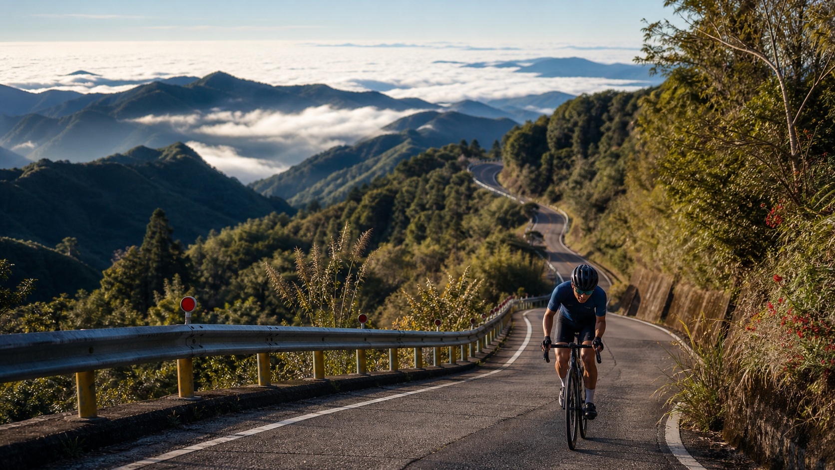
11.575 km, 6.4% average grade, 757 m total elevation gain—this long climb starting from a Tsou tribe village and leading to a viewing platform at nearly 2,000 m elevation has solid, credible data that deserves serious attention.
1. Let’s Lay Out the Numbers First
The official signage for the “Laiji Bridge to Dadongshan Trail” section of County Road 155 in Chiayi lists: total distance 11,575.0 m, total elevation gain 757.4 m, average grade 6.4%. Cross-checking distance against grade: 11,575.0 m × 6.4% ≈ 740.8 m, which is quite close to the stated 757.4 m total gain—a discrepancy of less than 20 m. The internal consistency of the data is good, so it can be reliably used as the basis for planning.
| Item | Data | Engineering Perspective |
|---|---|---|
| Total Distance | 11.575 km | Medium-to-long sustained climb |
| Total Elevation Gain | 757.4 m | Relatively evenly distributed throughout |
| Average Grade | 6.4% | Moderately hard intensity |
| Summit Elevation | Approx. 1,976 m (Dadongshan summit) | Classified as a high-altitude long climb |
One important clarification: Taiwan has two mountains with the same name, “Dadongshan”—one is located on the border of Baihe District, Tainan City, and Dapu Township, Chiayi County (Guanziling Dadongshan), while the other sits on the border of Meishan Township and Alishan Township, Chiayi County (Fenqihu Dadongshan), at approximately 1,976 m elevation, located 2.5 km east-southeast of Fenqihu Station on the Alishan Forest Railway. Based on the route description (starting from Laiji Village and following County Road 155), this route corresponds to Fenqihu Dadongshan on the Meishan/Alishan township border, not Guanziling Dadongshan in Baihe District. Be sure to recognize this geographic distinction when planning your trip to avoid confusing the two mountains with the same name.
2. Route Background: From a Tsou Tribe Village to a Kilometer-High Viewing Platform
The starting point, Laiji Village, is located in the northern part of Alishan Township, Chiayi County, covering approximately 23 square kilometers. It is an important settlement of the Tfuya branch of the Tsou people. The route departs from Laiji Bridge and climbs steadily to the entrance of the Dadongshan Trail. At the summit of Dadongshan, there is a viewing platform where you can enjoy the sunrise and take in panoramic views of Yushan (Jade Mountain), Data Mountain, Xiaota Mountain, and other peaks. It has become a popular starting point for hiking routes in recent years.
It is worth noting that although the name “Dadongshan National Trail” is widely used, according to administrative classification, this trail is actually categorized by the Forestry and Nature Conservation Agency as a regional trail system, not a national trail system. When writing or introducing it, avoid mislabeling its administrative level.
3. Section-by-Section Strategy: Breaking the 11.6 km into Four Segments
Segment 1 (0–3 km) Starting from Laiji Bridge: Entering Tsou Tribal Territory
Departing from Laiji Bridge, this is the most critical starting point for establishing your rhythm on the entire climb. The terrain around Laiji Village is characterized by steep riverbeds carved by the Alishan Creek, creating a unique geographic environment. The early section may pass through tribal settlement areas, so it’s advisable to slow down—not only for safety but also to give yourself the chance to absorb the atmosphere of this Tsou community. Power output is recommended to be controlled at around 76% to 82% of FTP, saving energy reserves for the 11+ km of climbing ahead.
Segment 2 (3–6.5 km) Into the Forest: Endurance Management on the Sustained Climb
After leaving the tribal settlement, the route gradually penetrates deeper into the forest, and the grade begins to increase steadily and consistently. This section is the core climbing zone of the entire route. It’s recommended to adopt a “seated position as the primary” strategy, maintaining a steady cadence (85 to 95 rpm) with a regular breathing rhythm, allowing your body to settle into a sustainable cruising output. As elevation gradually rises, temperatures will drop progressively, and it will feel noticeably cooler than at the start.
Segment 3 (6.5–9.5 km) Approaching the Trail Entrance: A Dual Test of Willpower and Physical Strength
As you near the Dadongshan Trail entrance, you’ll have climbed to a considerable elevation, and fatigue will accumulate noticeably. For this section, it’s recommended to fine-tune your strategy based on your physical condition. If you’re already feeling significant fatigue, prioritize maintaining stable form to avoid cramping or compromised pedaling mechanics from pushing too hard. If weather permits, this section also offers some of the most open views of the surrounding mountain landscape.
Segment 4 (9.5–11.575 km) The Finish: Final Push Toward Kilometer-High Elevation
For the last 2 km, focus on maintaining a steady cadence and breathing rhythm. After reaching the endpoint (the Dadongshan Trail entrance, at an elevation very close to the 1,976 m summit), if your energy and time allow, consider hiking the remaining trail section on foot to personally reach the summit and enjoy the magnificent views from the viewing platform.
4. Gear Ratio and Equipment Recommendations
Considering this is a medium-to-long, high-altitude climb with an average grade of 6.4%, a total distance of over 11 km, and a summit elevation of nearly 2,000 m:
- Front derailleur: A 50/34 compact crankset is recommended to ensure sufficient easy gears for the sustained climbing.
- Rear derailleur: At minimum, equip an 11-30T cassette. If you have limited climbing experience, a wider 11-32T cassette provides greater safety margin.
- Warm clothing: Due to the high elevation at the summit, temperatures will be significantly lower than at lower elevations. It’s recommended to carry a lightweight windbreaker or long-sleeve jersey, especially if you plan to linger at the summit to enjoy the views—warmth preparation becomes even more important.
- Brake system: If you plan to descend the same route, the long mountain descent places considerable stress on the braking system. Make sure your brake pads are in good condition and use intermittent braking to avoid overheating the rims.
5. Nutrition and Hydration Strategy
| Time Point | Nutrition Recommendation |
|---|---|
| 30 minutes before departure | Fully hydrate to ensure your body is in a well-hydrated state |
| Every 20–30 minutes | At least 150–200 ml of fluid |
| Midway (around the 6 km mark) | Consume one energy gel or portable snack |
| After reaching the endpoint | Replenish electrolytes; if planning to hike to the summit, add extra energy |
Stores are limited in Laiji Village and the surrounding mountain area, so it’s recommended to carry sufficient supplies with you rather than relying on roadside vendors.
6. Weather and Seasonal Considerations
The terrain and elevation conditions of Dadongshan are well-suited for viewing seas of clouds, and the summit’s panoramic views of the Yushan range are consistent with its topographic and elevational characteristics. If you choose to tackle this route in the early morning, besides the cooler temperatures being favorable for a long climb, you’ll also have the chance to enjoy sea-of-cloud views near the summit.
Since the endpoint elevation approaches 2,000 m, even in summer, summit temperatures can be significantly lower than at lower elevations, with large temperature swings between day and night. It’s recommended to prepare for warmth and wind protection. If tackling this route in winter, the mountain area may experience low temperatures or even frost—be sure to check weather conditions and prepare complete cold-weather gear.
7. Common Mistakes and DNF Risks
- Confusing the two Dadongshan mountains: Mistaking this route for Guanziling Dadongshan in Baihe District, Tainan, leading to incorrect trip planning.
- Underestimating high-altitude temperature differences: Failing to account for the sudden temperature drop at nearly 2,000 m elevation, resulting in insufficient warm clothing.
- Pacing out of control in the early section: Being misled by the relatively gentle terrain around Laiji Village and failing to reserve enough energy for the sustained climbing later.
- Insufficient supplies: Underestimating the fluid and energy demands of a high-altitude climb of over 11 km.
- Neglecting warmth on the descent: After reaching the summit, temperatures have already dropped. If you descend without proper warm clothing, wind chill can easily lead to hypothermia.
8. Target Time References for Riders of Different Levels
| Rider Level | Estimated Completion Time | Average Speed Reference |
|---|---|---|
| Advanced / Race level | 38–52 minutes | 13–18 km/h |
| Intermediate / Trained | 52–72 minutes | 10–13 km/h |
| Recreational / Climbing novice | 72–100 minutes | 7–10 km/h |
Jia 155 from Laiji to Dadongshan is a medium-to-long climbing route with reliable data and a rich blend of scenery and culture. Starting from a Tsou tribe village and climbing steadily to a viewing platform at nearly 2,000 m, it is a highly worthwhile challenge within Alishan Township, Chiayi County.
9. Power Training Perspective: The Training Value of High-Altitude Long Climbs
For riders with a power meter, Route Jia 155—with an average gradient of 6.4%, a distance of 11.575 kilometers, and a summit elevation of nearly 2,000 meters—is an ideal mid-to-long-distance Sweet Spot training venue. It is recommended to keep power output between 82% and 92% of FTP, sustaining this intensity zone throughout the climb. Due to the high summit elevation, oxygen concentration gradually decreases as you ascend, meaning the actual physiological load may be heavier than a route with the same gradient at lower elevation. It is advisable to moderately lower your power targets and closely monitor heart rate changes to avoid overexertion caused by high-altitude effects.
This training mode, combining the triple challenge of distance, gradient, and elevation, is particularly suitable for riders preparing to tackle other high-altitude long climbs in the Alishan highway system (such as the Zhushan or Shizhuo directions), serving as practical preparation for adapting to the load of high-altitude riding.
10. Route Safety and Traffic Information
As an important connecting road between the Laiji Tribe and the surrounding mountain areas, Jia 155 is not only used by cyclists but also serves as a primary passage for tribal residents and hikers. When riding, be sure to note the following: reduce speed when passing through tribal settlement areas and maintain basic respect for residents and pedestrians; the mountain roads have many curves and blind spots, so slow down well in advance before turns; if you plan to stop at the trailhead near the summit, be mindful of hikers’ activity areas to avoid interfering with each other’s safety.
Since the route’s summit is at nearly 2,000 meters elevation, mobile network signals may be unstable in some remote mountain sections. It is recommended to download offline maps and inform family or friends of your complete itinerary and estimated departure and return times in advance.
11. Post-Ride Recovery and High-Altitude Adaptation
After completing the Jia 155 long climb with a summit elevation of nearly 2,000 meters, it is recommended to allow your body time to adapt before descending, to avoid discomfort caused by rapid elevation changes. Dynamic stretching and adequate hydration can help your body gradually transition from the state of high-intensity climbing to the phase of preparing for descent. If you plan to descend via the same route, note that the elevation difference exceeds 700 meters, and temperatures will gradually rise during the descent. It is advisable to remove insulating layers progressively to avoid placing strain on your body from excessive temperature changes.
After returning to flat ground, adequate rest and nutritional replenishment are indispensable parts of recovery following this type of high-altitude, mid-to-long-distance climb. It is recommended to record the completion time, heart rate, and subjective fatigue levels of each challenge. Accumulating this data over time will help you more precisely understand your performance and progress on high-altitude long climbs.
12. Comparative Perspective with Other Alishan Township Routes
When placing Jia 155 from Laiji to Dàdòngshān within the coordinate system of Alishan Township’s overall climbing routes, it stands out as a quality route combining training value and cultural depth—thanks to its reliably moderate-to-hard intensity, coupled with the dual enhancement of Tsou tribal culture and a high-altitude viewpoint. Compared to Route 162 Jia Ruifeng introduced earlier (which requires conservative preparation due to contradictory data), Jia 155’s official data shows good internal consistency, allowing for more precise training intensity planning.
For riders preparing to tackle other renowned long climbs in the Alishan highway system, Jia 155 can serve as excellent preparatory training for adapting to high-altitude riding loads. This route allows you to verify your physical performance during elevation gain and whether your cold-weather preparation is adequate.
13. Collaboration Suggestions for Group Rides
If you choose to tackle the Jia 155 long climb with companions, it is recommended to thoroughly communicate with teammates in advance about the route’s characteristics—the high summit elevation and significant temperature changes—so that every rider is properly prepared with appropriate cold-weather gear. During the group ride, stronger riders should pace down from time to time to wait for less powerful companions. Especially on the high-altitude sections near the summit, if any rider shows obvious signs of exhaustion or discomfort, the group should stop and rest immediately rather than pushing on.
After arriving at the Dàdòngshān trailhead, if you plan to hike to the summit together to enjoy the magnificent views from the observation deck, it is recommended to properly distribute supplies among the group (such as warm clothing, drinking water, and a basic first-aid kit) so that the entire team can safely and comfortably complete this combined journey of cycling challenge and mountain hiking.
14. Appendix: Complete Pre-Departure Preparation Checklist
Considering the route’s summit elevation of nearly 2,000 meters and significant temperature variations, it is recommended to verify the following items in order before departure: bicycle condition (brake pad wear, drivetrain smoothness, chain lubrication, tire pressure and tire condition), cold-weather gear (lightweight windbreaker, long-sleeve jersey, gloves), nutrition supplies (at least 1.5 liters of water, energy gels or portable food, electrolyte supplements), emergency preparedness (basic first-aid kit, on-bike tool set, spare inner tubes, power bank), communication and itinerary notification (sufficient phone battery, offline maps downloaded, itinerary shared with family and friends), and weather confirmation (recent rainfall records, daily temperature forecast, mountain cloud and fog conditions). This checklist will help you more thoroughly plan this long climb from the Tsou tribe to the high-altitude viewpoint.
15. Conclusion: A Long Climb Connecting Tribe and Skyline
The Jia 155 route from Laiji to Dàdòngshān—with its reliable data, the profound cultural heritage of the Tsou tribe, and the magnificent panoramic views of the Yushan mountain range at the summit—has become a precious route within Alishan Township that combines both training value and cultural depth. Whether you want to accumulate experience in high-altitude long climbs or simply wish to explore this tribal land that retains its original Tsou character, this road deserves to be seriously included in your Chiayi riding map.
16. Overall Comparison with Other Routes in This Article
Reviewing the seven Taitung and Chiayi routes covered in this article, Jia 155 from Laiji to Dàdòngshān, like Route 3 Guanziling, belongs to the category of internally consistent and trustworthy data. However, in comparison, it adds a unique layer of Tsou tribal culture and a high-altitude viewpoint. If you were to choose one route from this article as the comprehensive top pick combining training intensity, cultural depth, and natural scenery, Jia 155 indeed has its distinctive merits—it does not carry the hidden concern of contradictory data like 162 Jia Ruifeng, nor is it merely a brief explosive power test like Luye Songlin. Instead, it offers a complete, solid, and richly layered long-distance journey.
17. Conclusion: Put Jia 155 on Your Long-Term Training and Exploration List
Taiwan’s indigenous tribes and surrounding mountain areas hide countless routes like Jia 155 that combine physical challenge with cultural depth, waiting to be discovered by riders willing to invest time in deep exploration. This long climb from Laiji Tribe to Dàdòngshān—with its solid 757.4 meters of elevation gain, the profound heritage of Tsou culture, and the magnificent summit views overlooking the rooftops of Taiwan—proves to every visitor that truly valuable riding experiences are never merely about breaking numbers, but about the complete sensations and deep connections this journey can bring you.
18. Quick Answers to Frequently Asked Questions
Q: Where exactly is Dàdòngshān? Is it the same mountain as the Dàdòngshān in Baihe District? No. Taiwan has two mountains with the same name. This article introduces the Fenchihu Dàdòngshān, located at the border of Meishan Township and Alishan Township in Chiayi County, at approximately 1,976 meters elevation. It is a completely different mountain from the Guanziling Dàdòngshān at the border of Baihe District in Tainan City and Dapu Township in Chiayi County. Be sure to confirm which one you are planning for before your trip to avoid heading in the wrong direction.
Q: Are the gradient data for this route reliable? Yes. Based on the cross-verification at the beginning of this article, 11,575.0 meters × 6.4% ≈ 740.8 meters, which is very close to the officially marked 757.4 meters of total elevation gain. The data shows good internal consistency and can be confidently used as a basis for training planning.
Q: Is it suitable for beginners? With an average gradient of 6.4%, a distance of 11.575 kilometers, and a summit elevation of nearly 2,000 meters, this is a moderately hard long climb. It is recommended that riders have a certain climbing foundation and long-distance riding experience before attempting it. Beginners may consider starting with shorter routes to build strength, gradually establishing the physical foundation and experience needed to take on high-altitude long climbs.
Q: Can I hike to the summit of Dàdòngshān after riding? Yes. The endpoint of the Jia 155 cycling route, the Dàdòngshān trailhead, is already quite close to the summit elevation. If your energy and time permit, it is recommended to park your bicycle securely and hike the remaining trail section to personally reach the summit and enjoy the magnificent views of Yushan, Dàtǎshān, and Xiǎotǎshān from the observation deck—extending this journey from a cycling challenge into a complete experience that combines riding with mountain hiking.
19. Conclusion: Put County Road 155 on Your Long-Term Riding and Exploration Map
Taiwan’s indigenous villages and surrounding mountain areas hide countless routes like County Road 155 that combine physical challenge with cultural depth, waiting for riders willing to invest time in deep exploration to discover. This long climb from Laiji Village to Mount Dandong, with its solid 757.4 meters of elevation gain, the rich heritage of Tsou culture, and the sweeping view of Taiwan’s central mountain spine at the summit, proves to every visitor—truly valuable riding experiences are never just about chasing numerical breakthroughs, but about the complete experience and deep connection the journey brings you. The next time you plan a riding trip in Alishan Township, be sure to put it on your shortlist.
20. Afterword: A High-Altitude Journey Worth Revisiting Again and Again
The County Road 155 route from Laiji to Mount Dandong, thanks to its reliable data, deep Tsou cultural background, and the sea-of-clouds and mountain-peak vistas at the summit that constantly change with seasons and weather, has become a precious route worth revisiting time and again, offering fresh experiences on every ride. Whether chasing sunrise and sea of clouds in the early morning, or capturing the sunset spilling across the peaks in the evening, this route reveals distinctly different yet equally moving faces at different times and seasons. May you incorporate it into your long-term riding plans, so that every return brings new discoveries and emotions.
21. Conclusion: A Triple Gift of Data, Culture, and Scenery
Looking back over this entire guide, the reason County Road 155 from Laiji to Mount Dandong deserves serious recommendation is that it simultaneously satisfies expectations on three levels—for data-driven riders, it provides reliable and credible gradient and elevation figures sufficient to support rigorous training planning; for travelers seeking deep cultural experiences, the Tsou naming of Laiji Village as Pnguu, along with the landscape stories of the Titanic Rock and Sanlong Bridge, offers rich humanistic depth; for riders who simply love natural scenery, the observation deck at Mount Dandong’s summit overlooking the Yushan range is an irreplaceable visual feast. These three gifts combined make County Road 155 the rare representative among this guide’s seven routes that possesses both data rigor and journey completeness, and the most suitable as the grand finale recommendation, worthy of priority scheduling in your itinerary. May you personally embark on this journey and harvest your own triple experience—rigorous training feedback, profound cultural heritage, and unforgettable sweeping scenery. All three are indispensable, yet on this long climb of County Road 155, you can possess them all at once—this is precisely the most important reason it deserves to be written into the hearts of every Chiayi cycling enthusiast, and the core value this guide most wants to convey to you.
Related Reading
- County Road 155 from Laiji to Mount Dandong: Riding from the Tsou Village of Pnguu to the Skyline of Sea of Clouds and Tashan Peaks
- Provincial Highway 3 Guanziling Practical Guide: An 11.5 km Mid-Distance Climb to One of Taiwan’s Four Major Hot Springs
- The Complete Guide to Taiwan’s Top Ten Classic Road Cycling Climbs: A Comprehensive Comparison of Difficulty, Scenery, and Supply Points
- Chiayi Alishan to the Yushan Trailhead: The Ultimate High-Mountain Road Climbing Challenge
一定要騎一次!阿里山最深處:里佳部落!單車旅行 | 2800m爬升 | 深度部落體驗:嗨翻晚會、螢火蟲、銀河 | feat. JJSC & 廢物伙伴 | 公路車 CT Yeh
9 個月前
台北闊瀨陡坡 騎旅 / 日本單車雜誌編輯車友臨時加入!/ 髮香才是最強的 / feat. 北迴歸線小隊 / 公路車 CT Yeh
6 個月前
嘉義大埔、阿婆灣挑戰賽,美到以為在日本!ft. 環騎5 Cool 西拉雅188 / 公路車 / CT Yeh
7 個月前
那瑪夏x茶山 阿里山系深山單車行 Day2 累積爬升6000M | 🥶超陡連續下坡 整路看隊友刷 | 爬升一座西進武嶺 | JJSC | 公路車 | CT Yeh
3 年前
新竹羅平 x 天湖部落 大禹嶺級變態陡坡! 4K超高畫質 空拍 | 公路車
5 年前
觀霧 變好騎了! | 北高車友爆笑大會師 | 公路車 | 單車旅遊 Taiwan Cycling Route GuanWu
6 年前
騎單車去大屯山賞雪! 助航台滑冰 全記錄 | 台北R友大集合 | 下雪打雪仗囉 | 4K超高畫質
5 年前
里佳部落 阿里山單車深度旅遊! | 竹山/草嶺/來吉/奮起湖 | 無敵銀河絕景 全新路線探索! 驚險狀況百出! | 4K沉浸式畫質 | 公路車 | CT Yeh
3 年前