Caoling Road Practical Guide: How to Ride Yunlin's 6.4km Mountain Training Climb with 429m of Elevation Gain
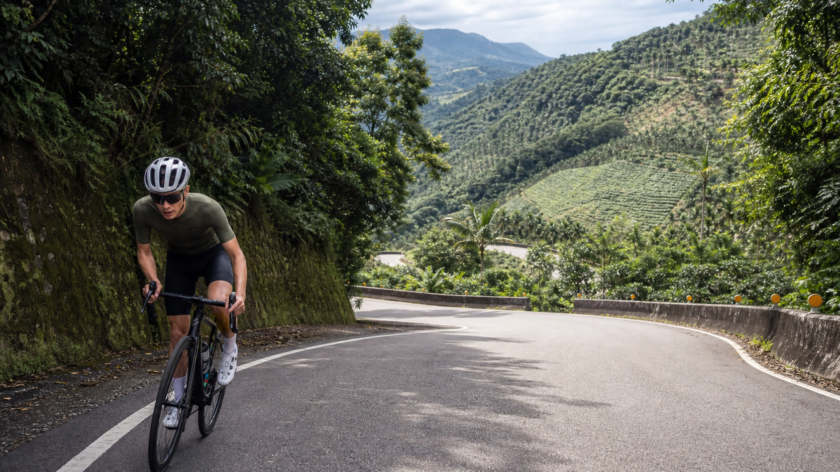
Route Overview and Data Analysis
Grass Ridge Road is one of the most representative climbing routes in Yunlin County. Starting from the outskirts of Zhushan Township and leading toward Gukeng’s Caoling area, it spans approximately 6.44 kilometers with a total elevation gain of 429.6 meters and an average gradient of 6.7%. By Taiwan’s cycling climbing route classification standards, this road qualifies as “medium-to-high intensity” (Strava Category 3). For casual weekend riders, it’s a challenge that requires advance preparation—yet it’s nowhere near the 20-30 kilometer endurance grind of routes like Wuling or Hehuan East Peak. Grass Ridge Road’s defining characteristics are “short, fast, and steep”—just over six kilometers, but with elevation packed into a relatively concentrated stretch. An average gradient approaching 7% means riders get almost no flat recovery sections to bring their heart rate back down.
Looking at the actual terrain, the Caoling area sits at the border between Gukeng Township and Zhushan Township in Yunlin County, part of the low-mountain terrain on the western flank of the Alishan mountain range. Elevations fall in the several-hundred-meter range—exactly the altitude band where central Taiwan’s hills are densely covered with tea and betel nut plantations. This is why riding along Grass Ridge Road means constantly switching between sections shaded by dense vegetation and sudden panoramic viewpoints—the terrain itself dictates that the gradient won’t be a uniform “steady slope,” but rather several particularly steep “attack zones” interspersed with relatively gentler stretches.
From a data perspective, a 6.7% average gradient multiplied by 6.44 kilometers yields a theoretical elevation gain of around 430 meters, closely matching the measured 429.6 meters. This indicates the route’s gradient distribution contains no anomalous data noise, making it a route with relatively clean, reliable gradient records. When planning training intensity, you can directly reference this data for power and heart rate estimates.
Key Data Overview:
| Item | Value |
|---|---|
| Total Distance | 6.44 km |
| Total Elevation Gain | 429.6 m |
| Average Gradient | 6.7% |
| Strava Category | Category 3 |
| Starting Administrative District | Zhushan Township |
This gradient combination means Grass Ridge Road is well-suited as a “simulation training ground” before tackling long-distance climbs of Wuling or Tataka grade—short enough that a single workout session can cover two or three round trips for intervals, yet steep enough to simulate the most demanding kilometers in the middle of a long climb. It’s a popular choice for weekend morning rides among cyclists in the Yunlin and Nantou area.
Start to Midway Point: Warm-Up and Probing Before Entering the Mountain
The start of Grass Ridge Road is typically set on the outskirts of Zhushan urban area, connecting to Provincial Highway 3 or County Road 154 before entering the mountains. This section can be treated as the “warm-up zone” before the real challenge begins. The gradient at the start of the climb is relatively gentle, but don’t be fooled by the early section’s deceptive ease—many riders push too hard here because it “feels manageable,” only to face a heart rate spike on the steeper sections later.
It’s recommended that on the final flat stretch before the start, you adjust your cadence to your habitual climbing rhythm (typically 75-85rpm), getting your body into climbing mode in advance rather than reacting on the fly when the gradient kicks up. After entering the actual climbing section, the gradient gradually builds over the first 1.5 kilometers or so. This is the critical transition period for your body to switch from flat-road cruising to climbing metabolism. It’s recommended to hold target power at around 75-80% of FTP, avoiding surging to near-threshold intensity right from the start.
Another characteristic of this section is the dense concentration of curves. The low-mountain terrain around Caoling forces the road to wind along contour lines, and consecutive hairpin turns make the gradient feel steeper than the actual numbers suggest—especially on the inside of corners, where the gradient can spike 2-3 percentage points momentarily. It’s recommended to take the outside lane when entering corners. Besides offering better visibility, this also smooths out gradient changes and reduces the need for frequent gear shifts.
Mid-Section Core Climbing Zone: Where the Race Is Truly Decided
Entering the middle section of Grass Ridge Road—roughly the 2km to 4.5km mark of the entire route—you reach the core climbing band where the average gradient is closest to, or even exceeds, the posted 6.7%. This section begins to feature sustained steep pitches, with instantaneous gradients on some stretches potentially reaching 9-10%. It’s the critical zone that tests a rider’s gear ratio choices and cardiovascular endurance.
Pacing Principles for This Section:
- Keep heart rate at 80-85% of max (or power at 85-90% of FTP), avoiding entry into the anaerobic zone
- Better to drop cadence to 65-70rpm than to muscle up steep sections with heavy gears—knee strain will show up directly in tomorrow’s soreness
- On consecutive hairpin turns, use the outside line to cut through gentler gradients and reduce instantaneous slope impact
- Fuel in small, frequent amounts—take sip-sized water breaks every 10-15 minutes, avoiding large gulps that can cause stomach discomfort
The most easily underestimated aspect of Grass Ridge Road’s middle section is that no clear summit is visible ahead, making riders prone to the psychological fatigue of “not seeing the end.” It’s recommended to identify key milestones in advance via route maps or GPS tracks (such as landmarks at the 3km and 4km marks), breaking the long climb into several mental segments with small goals set for each. This maintains rhythm more effectively than staring at the total distance countdown.
This is also why the route’s gradient data is particularly “clean” (measured gain vs. theoretical gain differs by only about 2 meters)—the sustained steep pitches in the middle absorb most of the elevation gain, while the front and rear sections are relatively uniform. This gives the route’s gradient curve a “hump-shaped” distribution with a raised middle. This terrain is especially friendly for interval training, as riders can precisely anticipate when to push intensity and when to ease off slightly.
Final Section and Arrival at Caoling: The Trap After the Gradient Eases
In the final 1.5 kilometers or so approaching the summit, the gradient typically begins to ease. This is where many riders make a tactical error—seeing the gradient numbers drop, they assume the work is “done” and relax their pace prematurely. As a result, by the time they actually reach the summit, their energy has been overly depleted in the earlier sections, and they end up losing time on the final gentle slope.
The correct approach is to maintain a steady cadence and heart rate even when you feel the gradient easing, treating this final stretch as “overtime” rather than a cooldown zone. Upon arriving at the Caoling area, the view opens up dramatically—the surrounding tea plantations, bamboo groves, and the geological landscape around Caoling Lake form a typical Yunlin mountain scene, marking the official completion of the core climbing effort.
It’s worth noting that the Caoling area has undergone geological changes from the 1999 921 Earthquake and subsequent typhoon damage. Mountain roads occasionally have rockfall and unstable roadbed sections, especially after rain or typhoons. Be sure to check the latest road condition announcements from highway authorities before riding—don’t rely solely on past experience to judge that road conditions are safe.
Gear Ratio and Equipment Recommendations
Given the 6.7% average gradient with localized sections potentially reaching 9-10%, Grass Ridge Road is definitely not a route that amateur riders can handle comfortably with a traditional 53/39T big chainring setup. Here are recommended configurations by rider level:
| Rider Level | Recommended Chainring | Recommended Cassette | Notes |
|---|---|---|---|
| Beginner/Recreational | Compact 50/34T | 11-32T or 11-34T | Ensures reserve cadence remains on steep sections |
| Advanced | Compact 50/34T or Semi-Compact 52/36T | 11-30T | Balances flat-road cruising and climbing efficiency |
| Competitive | Semi-Compact 52/36T | 11-28T | Pursues power output efficiency; fitness sufficient for steep grades |
For riders who don’t regularly encounter sustained steep climbs, it’s strongly recommended to configure at least a lightest gear combination of 34x32T or even 34x34T. The instantaneous gradients in Grass Ridge Road’s middle section are enough to force riders with insufficient power or overly heavy gearing to dismount and walk. This not only ruins the riding experience but also carries the risk of rear-wheel slippage when restarting on a steep slope after stopping—especially on wet roads after rain, where extra caution is required.
Nutrition, Weather, and Seasonal Advice
Caoliao Highway is only 6.44 km long, so in theory there is no need to carry a large amount of supplies. However, because the gradient is concentrated and the intensity is relatively high, it is still recommended to carry at least a 500-750ml water bottle and to be fully hydrated before the ride, rather than relying on refueling along the way. The Yunlin mountain area is hot and humid in summer, and during midday the combination of radiant heat from the ground and metabolic heat generated by climbing can quickly raise core body temperature. It is recommended to ride in the early morning or near dusk, avoiding the strongest sunlight between 11 AM and 2 PM.
Winter and early spring are the seasons with the best visibility and most comfortable temperatures on Caoliao Highway, with less mountain mist, making it ideal for scenic views and photography. During the plum rain season and typhoon season, special attention must be paid to the risk of falling rocks and landslides on mountain roads. The geology of the Yunlin mountain area is relatively fragile, so after heavy rain you should postpone your ride plan and keep an eye on closure announcements from the road authorities.
Common Mistakes and DNF Risks
Most riders who fail on Caoliao Highway do not lose due to insufficient fitness, but rather due to incorrect pacing strategy. The three most common problems are:
- Going out too hard in the early section: Misled by the relatively gentle gradient at the start, riders push at cruising power on flat roads up the steep slopes, causing their heart rate to blow up before the core climbing section in the middle even begins.
- Insufficient gear preparation: Underestimating the steepness of certain sections of this route, riders bring gearing that is too heavy and are forced to grind at extremely low cadence on steep sections, which can easily cause knee injuries.
- Relaxing too early in the final stretch: Misjudging the easing gradient as the end of the task, riders lose their rhythm before the final push, which actually extends their finishing time.
It is recommended that all first-time challengers first complete a full ride using the three-stage strategy of “conservative start, steady middle, persistent finish,” and then adjust their next summit strategy based on actual perceived effort data.
Target Time References for Riders of Different Levels
The following times are for reference only. Actual results will vary depending on fitness level, bike setup, and weather conditions on the day. It is recommended to use your own historical data as a baseline and progress gradually:
| Rider Level | Estimated Finish Time | Average Power Reference (70kg Rider) |
|---|---|---|
| Recreational Rider | 35-45 minutes | 150-180W |
| Advanced Club Rider | 22-28 minutes | 200-240W |
| Competitive-Level Rider | 15-20 minutes | 260W and above |
Although Caoliao Highway is not long in distance, its gradient and elevation gain are sufficient to serve as one of the standard routes for assessing your climbing ability. It is recommended to revisit this route regularly for time trials under the same conditions, which can effectively track the trajectory of your climbing power and fitness improvements. It is also a very practical training indicator section before planning longer challenges such as Wuling or Tataka.
It is worth noting that the reference value of a time trial depends on the consistency of test conditions. The same rider testing under different weather, different times of day, and different bike setups may see differences of several minutes in results. Therefore, it is recommended to test under similar environmental conditions (for example, always choosing early morning, similar temperatures, and days with low wind) so that results truly reflect fitness improvements rather than being skewed by external variables.
Training Plan Suggestions: Incorporating Caoliao Highway into a Periodized Plan
For riders with specific target events (such as road time trials, hill climbs, or long-distance challenge events), Caoliao Highway can be incorporated into a periodized training plan as a field training venue for “threshold-intensity climbing intervals.” Below are several common training plan design directions for coaches and self-trained riders to reference:
Plan One: Single Full-Effort Time Trial
Schedule one every four to six weeks. Ride the entire route at full effort and record time, average power, and average heart rate as objective indicators of fitness progress. Be sure to complete at least 15-20 minutes of progressive warm-up before the test to avoid injury from sprinting from a cold state.
Plan Two: Repeated Climbing Intervals
If time and energy allow, ride Caoliao Highway back and forth 2-3 times, climbing each lap at 90-95% of FTP, using the descent as recovery, thereby accumulating total time at high-intensity climbing. This plan is particularly suitable for the mid-phase training stage six to eight weeks before preparing for long-distance climbing events such as Wuling or Hehuan Mountain.
Plan Three: Alternating Seated and Standing Climbing Training
The continuous steep sections in the middle of Caoliao Highway are ideal for practicing the alternation between seated climbing and standing climbing. It is recommended to switch positions at fixed distance points (for example, every 500 meters) to train endurance distribution across different muscle groups, while also relieving localized soreness caused by maintaining the same position for extended periods.
When planning such interval or repeated training, be sure to pay attention to general road conditions on Yunlin mountain roads. Although traffic on Caoliao Highway is not particularly heavy, local residents and agricultural vehicles still use the road. When riding back and forth or training in place, choose sections with good visibility and ample passing space, always watch for oncoming traffic, and never make U-turns or brake suddenly on curves or in blind spots.
Transport Connections and Linking with Surrounding Routes
For riders coming from other counties to challenge Caoliao Highway, it is recommended to link this route with other well-known sections in the Yunlin and Nantou area to form a half-day or full-day ride itinerary. Caoliao Highway is adjacent to the Qingshui River basin. Heading toward Zhushan town center, you can connect to the relatively gentle riverside bike path as a warm-up or cool-down section. If fitness and time permit, you can also plan to connect to the industrial roads around Caoliao and Taihe mountain areas, extending into a longer rolling-terrain training route.
Since the options for connecting roads in the Caoliao mountain area are limited, it is recommended to allow extra buffer time when planning your route. Especially on weekends, mountain roads may become congested due to tour buses and passenger cars entering scenic areas. Riders should prioritize safety, yield to large vehicles when appropriate, and avoid overtaking rashly on sections with poor visibility.
Safety Reminders and Precautions
Caoliao Highway is a mountain road, and road conditions change with the seasons and weather. The following safety reminders are recommended for all riders to keep in mind:
- Slow down on descents: The descent after completing the climb also features continuous hairpin turns. Do not exceed the limits of your braking and cornering ability on the descent. Mountain roads typically have no guardrails on the shoulders, and the cost of an accident is extremely high.
- Be cautious after rain: The geological conditions around Caoliao are relatively fragile, and combined with the impact of the 921 earthquake and typhoon damage in the past, some mountain sections are prone to falling rocks or loosening roadbeds after heavy rain. It is recommended to wait at least one to two days after heavy rain before going, and to keep an eye on announcements from the road authorities.
- Equipment inspection: Before departure, be sure to check brake pad wear, tire pressure, and tread condition. Climbing in the mountains places far greater demands on the braking system than riding on flat roads, and continuous braking on descents can easily cause brake pads to overheat.
- Communication and positioning: Mobile network signals are weak in some sections of the Caoliao mountain area. It is recommended to inform family or friends of your planned route and expected return time before riding, and to carry a power bank for emergency contact.
Overall, Caoliao Highway is a highly cost-effective training and challenge route: short in distance and relatively easy to access, yet featuring a gradient combination sufficient to simulate the mid-race intensity of long-distance climbing events. Whether as a test section before long-distance challenges like Wuling or Tataka, or simply as a training target for a holiday morning ride, it is well worth adding to the regular training list for riders from Yunlin, Nantou, and even across central and southern Taiwan.
Interpreting Power Data: Understanding Your Climbing Efficiency Through Watts
For riders equipped with a power meter, Caoliao Highway is an excellent teaching tool for practicing “power pacing.” The most common mistake on climbing sections is pacing by “feel” rather than “data”—especially on sections with dramatic gradient changes, where perceived fatigue often lags several seconds behind actual output intensity. By the time you realize you have pushed too hard, you have often already accumulated a significant “oxygen debt.”
It is recommended that riders confirm their FTP (Functional Threshold Power) value before riding and set zones accordingly: for the entire Caoliao Highway, recreational riders can set their target average power at 70-75% of FTP, advanced riders can raise it to 80-85%, and competitive riders chasing personal bests can attempt to push average power close to 90% or more of FTP—but this requires excellent lactate tolerance and is not suitable for everyone. Challenging it recklessly can easily cause a blow-up in the middle section, ultimately hurting overall performance.
Another important use of power data is post-ride analysis. After completing the ride, it is recommended to review the power curve in training software to identify sections where power suddenly spikes (usually corresponding to the steepest hairpin turns) and sections where power drops noticeably (possibly indicating depleted energy or mental lapse), in order to fine-tune your pacing strategy for the next attempt. Accumulating this type of data over time helps riders more precisely understand their true output capability across different gradient ranges, rather than guessing from memory.
Common Q&A: Practical Questions Cyclists Want to Know
Q: Is Caoling Road suitable for beginners to challenge?
In terms of gradient and distance, the intensity of Caoling Road is indeed higher than typical beginner training routes, but precisely because the distance is short, even if you need to dismount and walk or take a break along the way, it won’t consume too much time or energy. It is recommended that beginner riders approach their first attempt with a mindset of “completing the ride as the goal, not chasing speed,” paired with a lighter gear ratio setup, and gradually build up climbing experience.
Q: Do I need to prepare a feed station for riding Caoling Road?
Since the total length is only 6.44 km, mid-ride refueling is generally not needed during a formal attempt, but it is recommended to confirm your water bottle is full before starting, and to replenish electrolytes and energy in Zhushan town after finishing. If the weather is hot, it is advisable to carry simple energy gels for emergencies when your strength runs low.
Q: Is this route suitable for group rides?
Caoling Road has many corners and steep gradients. If riding as a group, it is recommended to control the group size and agree in advance on yielding and spacing rules to avoid collisions on steep sections or corners due to overly dense pacing. For groups with significant fitness differences, it is recommended to depart in waves and regroup at the summit, rather than forcing everyone to maintain the same rhythm, which could overexert some riders.
Q: Can Caoling Road be ridden in the rain?
Not recommended. The geological conditions in the Caoling Road mountain area are relatively sensitive. Riding in the rain not only increases the risk of slipping on wet pavement, but poor visibility also affects braking distance and reaction time on descents. If rain occurs on the day of your ride, it is best to reschedule—safety always takes priority over ride plans.
Conclusion: A Training Route Worth Revisiting Again and Again
Caoling Road may not have the nationwide fame of well-known routes like Wuling or Hehuanshan, but for cyclists in central and southern Taiwan, it is a “right at your doorstep yet unrelenting” practical training ground. The 6.44 km distance is compact enough for riders to complete a solid high-intensity workout within limited holiday time; the 429.6 meters of elevation gain and 6.7% average gradient are sufficient to simulate the most mentally demanding sections of long-distance climbing races.
Whether your goal is preparing for the Wuling challenge, local amateur road races, or simply tracking your climbing progress through data, Caoling Road deserves a place on your regular training list. It is recommended to use a power meter or heart rate monitor to record data from each attempt. Over time, you will clearly see your growth curve from “barely finishing while gasping for air” to “steadily pacing and conquering the summit.”
Related Reading
- Gukeng Huashan Dadudi Practical Guide: A 6.88 km, 447 m Climb in Yunlin’s Mid-Altitude Test
- Shibi Yunling Zhiqiu Practical Guide: The Art of Endurance and Pacing on a 10.76 km Long, Gentle Climb
- Yunlin Caoling Historic Trail: A Sanctuary for Northern Taiwan Hikers and Cyclists
- Wuling Full 52.2 km Segment Pacing Strategy: A Rhythm Map from Puli to the Ridge
台北闊瀨陡坡 騎旅 / 日本單車雜誌編輯車友臨時加入!/ 髮香才是最強的 / feat. 北迴歸線小隊 / 公路車 CT Yeh
6 個月前
#北橫 + #北進武嶺 最硬的員工旅遊 EP1 | #公路車 #拉拉山 | 明池 | 武嶺 | 武陵農場 | 雲海 | Taiwan Cycling Route Wulin
6 年前
#公路車 #西進武嶺 配速配瓦實驗 坡度分析 四小時內攻略 建大盃 NeverStop #西進武嶺攻略
6 年前
風櫃嘴時間 預測西進武嶺時間?13000名車友統計數據分析告訴你 !
5 年前
大禹嶺 到 武嶺牌樓 全程前後實況錄影 | 北進武嶺 | 東進武嶺 | KOM | 訓練台 | 坡度分析 | Taiwan KOM Last 10 km HARD | 公路車
6 年前
雨戰! 西進武嶺員工旅遊 加料 各路段大數據分析 | 同事端出5公斤的公路車來挑戰!? EP1
4 年前
單車 梅山36灣 坡度介紹 路段介紹 空拍 (相關遊記影片,請參考說明或我的頻道喔,歡迎訂閱)
6 年前
FTL 與 SYB 車隊專訪 西進武嶺 實用攻略分享! 2小時 如何練?!你不知道的眉角!新手準備武嶺必看 EP1 | 實力派女車友 | 精華版 | 公路車 | CTYeh
4 年前