Guanwu Dalu Forest Road Battle Guide: 27.3 km, 1,540 m of Climbing, a Marathon-Style Long Ascent Toward Clouds and the King of Cherry Blossoms
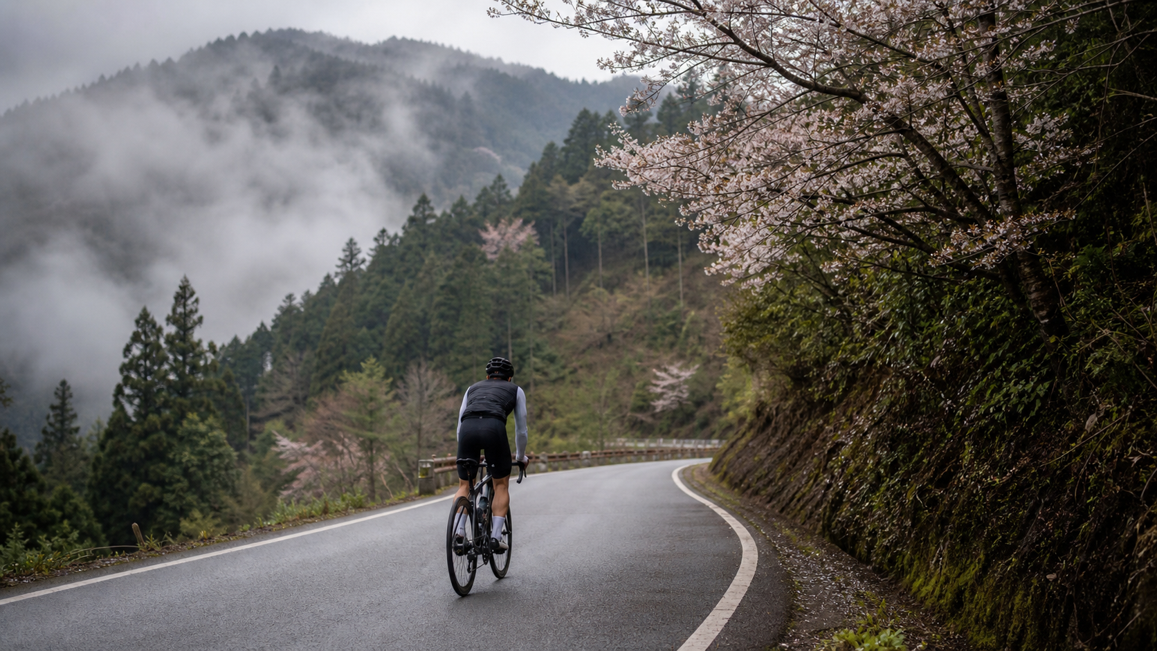
Guanwu Dalu Forest Road Practical Guide: 27.3 km, 1,540 m of Climbing, a Marathon-Style Long Climb into the Clouds and the Cherry Blossom King
Introduction: An Underrated “Marathon-Style” Climb
In Taiwan’s road cycling community, when it comes to hardman climbs, the first names that come to mind are usually the “classics” like Wuling, Hehuan North Peak, and Daxueshan. But if you’ve already ridden these famous mountains and are looking for the next goal, the “Guanwu” route absolutely deserves a spot on your shortlist. This climb, starting from the Zhang Xueliang entrance and running all the way to the 22K checkpoint of Dalu Forest Road (the section near the police checkpoint), measures 27,302.8 meters on the Strava segment—that’s 27.3 kilometers—with a total elevation gain of 1,540.8 meters and an average gradient of 5.6%.
Looking at the numbers alone might not make much of an impression, but put them together and you’ll see this is a textbook “marathon-style” long-distance climb: it’s not a short, brutally steep ascent like the nine bends and eighteen curves of the Beiyi Highway, nor is it a “sprint-style” mountain road that’s over within five or six kilometers. Instead, it demands that you sustain a steady, consistent power output for over 27 kilometers, lasting anywhere from roughly an hour and a half to three hours (depending on rider ability). A quick calculation to verify: 27.3 km multiplied by a 5.6% average gradient gives a theoretical climb of about 1,529 meters, which almost exactly matches the official figure of 1,540.8 meters. This means the route’s gradient distribution is relatively stable, with no violent “brutal sections” of dramatic swings—it’s a long climb with a relatively linear gradient curve, well-suited for finding a rhythm.
This is also what makes the Guanwu route both most charming and most demanding: there are no shortcuts, only endurance. You have to learn to pace yourself, to endure, and to find your own breathing and pedaling rhythm over the long ascent. This article will cover everything from the most solid perspective—route overview, segment-by-segment strategy, gearing and equipment, nutrition strategy, weather considerations, common mistakes, target times, and pre-ride training recommendations—to help you prepare every aspect of this route.
1. Route Overview and Data Analysis: Placing Guanwu on Taiwan’s Climbing Map
The best way to understand the difficulty positioning of the Guanwu route is to compare it with other well-known Taiwanese climbs. Wuling (taking Cingjing to Wuling as an example) spans over 30 kilometers with elevation gain approaching 2,000 meters or more, and the average gradient typically stays above 6%—it’s a “ultra-marathon type” that tests extreme endurance and management of fatigue over a long warm-up period. The Hehuan North Peak climb has a relatively gentler gradient but a longer distance, making it a “progressive scenic type.” Daxueshan Highway is famous for its “violent steep sections,” with multiple segments exceeding 10% and even approaching 15% in the middle—a “close-quarters combat” test of muscular strength. Alishan Highway (taking Chiayi City to Alishan as an example) exceeds 50 kilometers, making it an “ultra-long-distance attrition type” where the contest is more about nutrition and psychological endurance.
Guanwu, on the other hand, with its 27.3-kilometer distance, 1,540.8-meter climb, and 5.6% average gradient, sits right in a sweet spot between “medium-distance” and “long-distance”—long enough to experience the challenge of sustained, steady output; substantial enough in elevation gain to put clear load on your legs and cardiovascular system; yet with a 5.6% average gradient that lacks the punishing violent steepness of Daxueshan. This means that as long as you pace correctly and manage your heart rate zones, this is a route you can “ride to completion” rather than one that “beats you down with gradient.”
What does this gradient distribution mean for the rider? Simply put, it doesn’t test whether you can produce an instantaneous maximal power output to overcome a 15% wall, but rather whether you can sustain a maintainable output intensity over nearly two to three hours while managing perceived fatigue, nutrition rhythm, and mental state. This is why I’ve positioned it as a “marathon-style” climb in the title—it’s not about explosive power; it’s about endurance and discipline.
Another point worth mentioning: the finish area of this route enters the Shei-Pa National Park Guanwu Recreation Area, reaching an elevation of around 2,000 meters in the high-mountain zone. The higher the altitude, the lower the oxygen content. For riders from the lowlands, even if power output is the same as usual, subjective breathlessness and fatigue will be noticeably higher. This is one of the variables that must be factored into planning this route, especially in the latter sections approaching the 22K checkpoint of Dalu Forest Road, where the rider’s body is typically already in a relatively fatigued state. Combined with the reduced oxygen at higher elevations, the final few kilometers can feel especially long.
2. Start-to-Finish Segment Strategy: Breaking 27 Kilometers into Five Sections
When facing a 27.3-kilometer long climb, the worst approach is to treat it as a single challenge to be “ridden in one breath.” Experienced long-climb riders all know that breaking a long route into smaller psychological chunks is a key technique for controlling pace and maintaining focus. Below, the entire route is roughly divided into five sections of about 5–6 kilometers each, with pacing and heart rate zone reference strategies for each.
Section 1 (0–5 km, attacking from the Zhang Xueliang entrance): This is the opening move of the entire climb. Physically, your body hasn’t fully warmed up yet, and both muscles and cardiovascular system need time to get going. The most common mistake in this phase is “starting too hard”—because fatigue hasn’t accumulated yet, many riders charge out at near-maximal effort, only to pay the price in the middle and later stages. It’s recommended to keep your heart rate at about 70%–75% of your maximum (roughly the Zone 2 to Zone 3 boundary), with a rating of perceived exertion (RPE) of 4–5 out of 10, letting the body gradually warm up rather than forcing yourself into the anaerobic edge from the start. A cadence of 75–85 rpm in the mid-to-high range is recommended, avoiding grinding a heavy gear with leg strength—save that muscular fatigue for later.
Section 2 (5–10 km, entering the steady climb phase): In this section, the gradient begins to reveal the route’s “sustained” nature. There won’t be overly extreme steep sections, but you’ll start to feel the fatigue of “why is it still climbing.” This is the most important stretch for establishing rhythm. It’s recommended to find a breathing cadence you can maintain without being too breathless to speak, paired with a steady cadence, letting the body enter a near “autopilot” state. Heart rate can rise slightly to 75%–80%, with RPE around 5–6. This is also where you should start your first small intake of nutrition—don’t wait until you’re hungry to eat.
Section 3 (10–16 km, the mid-section that tests willpower): This is the stretch most prone to mental fatigue on the entire route. You’re past halfway, but the finish still looks far away, perceived fatigue is accumulating, and the novelty of the scenery may fade as altitude rises and clouds thicken. The most important psychological strategy in this phase is “don’t think about how far is left”—instead, focus on the pedaling rhythm of the 100 or 200 meters directly ahead. Heart rate can be maintained between 75%–82%, but pay close attention to whether you’re unconsciously pushing it too high—blowing up in the middle is one of the most common causes of DNF on long climbs. This section is also where you should take your second formal nutrition break, consuming a snack bar or energy gel, and ensure fluid intake hasn’t lapsed.
Section 4 (16–22 km, deep into Dalu Forest Road with gradient changes): As you gradually approach the 22K checkpoint of Dalu Forest Road, the route enters relatively remote mountain terrain. The forest composition changes noticeably, and temperatures drop with rising altitude. This section may feature slightly rolling gradients. It’s recommended to stay flexible—on slightly steeper sections, ease off the cadence and stand to change position for relief; on relatively gentler sections, quickly settle back into the saddle, letting your core and leg muscles alternate the load. Heart rate can be fine-tuned to 78%–85% depending on how you feel, but be sure to save some reserve for the final push—don’t burn all your ammunition in this phase.
Section 5 (22–27.3 km, the final test of will before the finish): This is the final stretch where you’ll need to rely most on willpower to push through. Fatigue has accumulated to its peak, and with altitude continuing to rise and oxygen levels dropping, subjective effort will climb noticeably, with RPE potentially reaching 7–8. At this point, it’s recommended to slow the pace—not to go fast, but to go steady: use the lowest intensity at which you can keep the pedals turning to reach the finish, while reminding yourself to keep drinking water and stay warm (especially if clouds are shrouding the area, as the perceived temperature will be much lower than expected). When you finally see the road signs approaching the 22K checkpoint of Dalu Forest Road and the police checkpoint, that sense of accomplishment will be the best reward of the entire journey.
3. Gearing and Equipment Recommendations
A 27.3-kilometer long climb with a 5.6% average gradient and over 1,500 meters of total elevation gain makes the gearing requirements very clear: you need a light enough gear to maintain a steady cadence even in a state of accumulated fatigue in the latter stages, rather than being forced to grind with brute force. Below is a gearing configuration reference table by rider ability level.
| Rider Level | Recommended Crankset | Recommended Cassette | Minimum Gear Ratio Reference | Notes |
|---|---|---|---|---|
| Advanced/Competitive | 50-34T (compact) | 11-28T or 11-30T | Approx. 1.13–1.21 | Stable average power output throughout; for those with some climbing experience |
| Intermediate/General recreational | 50-34T (compact) | 11-32T or 11-34T | Approx. 1.0–1.06 | Recommended to choose a lighter cassette to preserve energy for the latter stages |
| Beginner/First long climb | 46-30T or lighter small chainring | 11-34T or above, or with mountain-style rear derailleur conversion | Below 0.88 | Prioritize finishing over speed; a light gear ratio is a lifesaver |
Beyond gearing, the following equipment recommendations should not be overlooked:
- Wheels and tire pressure: For long climbs, it’s recommended to choose relatively durable training tires or wear-resistant road tires with stable grip. Adjust tire pressure based on body weight and road conditions—mountain roads occasionally have fallen leaves and gravel, and overly high pressure increases the risk of slipping.
- Brake system: Although this route is primarily climbing, don’t forget that the descent is also a 27-kilometer long downhill. Be sure to check brake pad wear and whether hydraulic brake fluid lines or mechanical cables are functioning properly before setting out. Continuous braking on a long descent can cause heat fade; it’s recommended to periodically ease off the grips to let the brake system cool down.
- Layered clothing: Guanwu’s elevation approaches 2,000 meters, and the temperature difference between day and night in the mountains, along with the perceived temperature when shrouded in clouds, can be more than 10°C lower than the lowlands. Layered dressing is recommended—a moisture-wicking base layer, an insulating mid layer, and a windproof/waterproof outer layer—so you can easily add or remove layers based on how you feel.
- Lighting and reflectors: If you plan to start before dawn or are concerned about finishing the descent late, be sure to carry front and rear lights and reflective accessories. Mountain roads have limited lighting, and safety is always the top priority.
- Bike preparation: Before departure, make sure the drivetrain shifts smoothly, the chain is lubricated, and brake feel is normal. If a mechanical failure occurs mid-ride on a long climb, support stations and bike shops are extremely scarce in the mountains. Self-inspection and basic repair tools (spare tubes, pump or CO2, hex wrench set) are essential.
4. Nutrition and Hydration Management: The Key Deciding Factor for a 27-Kilometer Distance
The factor most often overlooked on long climbs—yet often the one that determines success or failure—is nutrition and hydration management. Over 27.3 kilometers, with an estimated duration ranging from an hour and a half to three hours (depending on rider ability), the body loses significant amounts of fluid and electrolytes. Without a planned nutrition schedule, you can easily “hit the wall” (bonk) in the latter stages—a state of plummeting blood sugar, muscle weakness, and mental fog that, in severe cases, can make it impossible to continue riding.
Fluid planning: A general recommendation is 500–750 ml of fluid per hour. Considering the humid heat during the climb and the drier air at higher elevations in the latter stages, it’s recommended to carry at least two bottles (totaling about 1,000–1,500 ml). If the weather is hot or you sweat heavily, increase to three bottles or use a hydration pack. Before departure, be sure to confirm whether there are shops or rest stops along the route where you can refill water. Supply points along Dalu Forest Road are relatively scarce, so plan on the principle of “carrying enough yourself” rather than relying on being able to buy water along the way.
Electrolyte replacement: Prolonged sweating causes significant loss of electrolytes such as sodium and potassium. If you only replenish plain water without electrolytes, you risk cramps or hyponatremia. It’s recommended to add electrolyte powder or sports drink to your bottles, or carry salt tablets, supplementing as needed based on sweat rate each hour.
Snacks and energy gels: It’s recommended to consume 30–60 grams of carbohydrates per hour, which can be done through energy gels, bananas, energy bars, or traditional brown sugar ginger tea and salted nuts. The first formal nutrition break should be scheduled about 40–50 minutes into the ride (corresponding to Section 2 of the segment strategy above), when glycogen stores begin to decline—supplementing early can prevent a blood sugar crash. The second nutrition break should be scheduled around the middle section (roughly 1.5 hours in) to ensure sufficient fuel reserves for the final battle of willpower.
The psychology of nutrition timing: Many riders make a common mistake—delaying nutrition because they “don’t feel hungry or thirsty yet,” only to find that by the time they actually feel hunger or thirst, the body is already in a state of energy and fluid deficit, and the effectiveness of replenishment is greatly diminished. The correct approach is “timed nutrition” rather than “feel-based nutrition”—set a watch or bike computer reminder to take small sips every 20–30 minutes and consume a snack every hour. Use discipline instead of sensation to maintain stable blood sugar and fluid balance.
5. Weather and Seasonal Recommendations: Guanwu’s Cloud, Fog, and Temperature Traps
As the name suggests, the Guanwu area is a high-mountain recreation area frequently shrouded in clouds and fog. Combined with its elevation of nearly 2,000 meters, the intensity of weather changes far exceeds what lowland riders might imagine. Even if the sun is blazing at the base, you may suddenly enter a cloud-shrouded zone in the middle and latter stages of the climb, with reduced visibility, plummeting temperatures, and slippery roads—all variables that must be seriously addressed when planning this route.
Temperature and perceived temperature: Generally speaking, air temperature drops about 0.6°C for every 100 meters of elevation gain. At Guanwu’s elevation of nearly 2,000 meters, temperatures at the summit area can be more than 10°C lower than the lowlands. Add the moisture from cloud cover and wind chill effects, and the perceived temperature will be even lower. It’s recommended to carry a lightweight windbreaker even in summer to handle the cold at the summit area and during the descent.
Clouds, fog, and visibility: Guanwu’s clouds and fog typically thicken in the afternoon as moisture rises. It’s strongly recommended to plan for an “early morning departure”—first, to avoid the period of densest afternoon fog, and second, to avoid the afternoon thunderstorms that are common in mountain areas. If you encounter sections of dense fog with significantly reduced visibility, be sure to slow down, turn on your lights, and stay alert. With many curves on mountain roads, risk increases significantly when visibility is poor.
Rain gear preparation: Mountain weather can change in an instant. Even if it’s sunny at departure, it’s recommended to carry a lightweight rain jacket or waterproof shell just in case. If you get soaked, combined with high altitude and low temperatures, the risk of hypothermia rises dramatically—this is a safety issue that must be taken seriously on long mountain rides.
Seasonal reminders: Around March each year, mountain cherry blossoms enter their peak bloom in the Guanwu area, the most famous being the massive old cherry tree known as the “Cherry Blossom King,” which draws many visitors and photography enthusiasts on dedicated pilgrimages. This is also the origin of the phrase “Are you going to see the Cherry Blossom King?” in descriptions of this route. If you plan to visit during the blooming season, it’s recommended to check the exact bloom status for that year and the latest information from the national park in advance, as bloom times can shift slightly earlier or later each year depending on climate. Additionally, traffic and visitor crowds increase noticeably during the season, so plan to depart early and pay attention to riding safety on sections shared with vehicles and pedestrians. Beyond spring cherry blossom viewing, Guanwu offers different mountain scenery in each season due to its elevation and terrain. When planning your trip, defer to the latest official announcements and on-site conditions.
6. Common Mistakes and DNF Risks
Failures (DNF, Did Not Finish) on long climbs are rarely caused by a single massive error, but rather by the accumulation of a series of small oversights. Below are several of the most common mistakes on long, mid-to-high-elevation climbs like Guanwu.
Mistake 1: Going too fast early, collapsing late. This is the most classic and common error. Many riders see that the first few kilometers are relatively gentle and feel easy, so they can’t resist speeding up—only to find that by the middle and latter stages, muscular and cardiovascular fatigue accumulates rapidly, the planned pace falls apart, and they even experience leg weakness or cramps. The solution is to strictly adhere to the segment pacing strategy described above, using heart rate and RPE as objective throttle valves rather than riding by feel.
Mistake 2: Insufficient nutrition planning or poor timing. As mentioned earlier, nutrition should be executed on a disciplined schedule, not when you feel hungry or thirsty. Many DNF cases aren’t due to insufficient fitness, but rather to plummeting blood sugar and electrolyte imbalance in the latter stages causing cramps or mental fatigue, forcing an early abandonment.
Mistake 3: Underestimating the risk of hypothermia at altitude. The Guanwu area has highly variable cloud cover and large temperature swings. If you set out in standard summer cycling kit without any insulating or windproof gear, a drop in temperature or rain can easily trigger hypothermia symptoms—including shivering, confusion, and slowed movements—during the latter part of the climb or on the descent. This is a safety risk that demands serious attention.
Mistake 4: Insufficient preparation for mechanical failures. On long mountain routes, support stations and bike shops are scarce. If you don’t perform basic bike checks (brakes, shifting, tire pressure, chain maintenance) before departure, and a chain break, flat tire, or shifting failure occurs mid-ride without basic repair tools on hand, you can easily be forced to end the challenge early—or even find yourself waiting for rescue.
Mistake 5: Ignoring gearing configuration and grinding heavy gears. Some riders insist on using the same gearing they use on flat terrain for long climbs, only to be forced into extremely low cadence grinding on sustained gradients. Leg muscle fatigue accumulates far faster than when using appropriate gearing and maintaining a mid-to-high cadence. This is also a common cause of prematurely depleted energy in the latter stages.
7. Target Time References for Different Rider Levels
Below is a rough target time reference table to help riders of different levels set reasonable challenge goals. Please note that actual completion times are affected by factors such as weather, wind direction, personal fitness condition, and rest stops on the day. The figures below are for reference only—never push yourself beyond safe limits just to chase a time.
| Rider Level | Estimated Completion Time (climb only) | Reference Average Power (W/kg, approximate) | Recommended Heart Rate Zone |
|---|---|---|---|
| Competitive/Experienced | Approx. 80–100 min | Approx. 3.2–3.8 W/kg or above | Primarily Zone 3–4 |
| Advanced recreational | Approx. 100–130 min | Approx. 2.5–3.2 W/kg | Primarily Zone 2–3 |
| General intermediate | Approx. 130–170 min | Approx. 2.0–2.5 W/kg | Primarily Zone 2, with intermittent Zone 3 |
| Beginner/First long climb | Approx. 170 min or more, including rest | Approx. 1.5–2.0 W/kg | Goal is to finish; heart rate zones not emphasized |
One important reminder: the purpose of this table is not to encourage riders to compare speeds with others, but to help you set a reasonable challenge goal that is “your own.” The most important achievement on a long climb is always “finishing safely,” not chasing a specific time number.
8. Pre-Ride Training Recommendations: A 4–6 Week Endurance Climbing Preparation Plan
Facing a 27.3-kilometer climb with 1,540.8 meters of elevation gain, if you don’t have a regular long-distance riding training habit, it’s recommended to set aside at least 4–6 weeks of dedicated preparation to progressively build your body’s ability to adapt to prolonged climbing loads.
Weeks 1–2 (Base endurance building phase): The focus of this phase is accumulating long-duration, low-to-moderate intensity riding hours, not chasing speed or intensity. It’s recommended to schedule 2–3 rides per week, with at least one being a 90-minute or longer ride on flat or gently rolling terrain, with intensity controlled at an RPE of about 4–5. The goal is to build an aerobic base and muscular endurance while allowing the body to adapt to the postural load of long hours in the saddle.
Weeks 3–4 (Climbing-specific strengthening phase): In this phase, begin incorporating actual climbing training. Look for climbs near home with gradients between 4%–8% and lengths of at least 3–5 kilometers for repeated intervals. A “pyramid-style” training method is recommended: first climb one rep at moderate intensity, recover, then do a second rep, gradually increasing the continuous climbing distance and time to simulate the sustained-effort rhythm of each 5–6-kilometer segment in the Guanwu segment strategy. This phase is also a good time to practice your nutrition intake rhythm—actually test whether your chosen energy gels and snacks agree with your stomach during training rides, rather than trying new nutrition products for the first time on challenge day and risking gastrointestinal distress.
Week 5 (Long-distance simulation integration phase): This week, schedule a simulation ride with distance and elevation gain as close to the Guanwu route as possible—for example, find a route of 20 kilometers or more with over 1,000 meters of climbing for a full dress rehearsal. Test your pacing strategy, nutrition plan, and equipment configuration end to end, and record your body’s responses and fatigue points during the ride as a basis for adjusting your official challenge strategy.
Week 6 (Taper and recovery phase): In the week before the challenge, significantly reduce training intensity and volume to let the body recover from the previous weeks’ training load and store sufficient energy for the official challenge. This phase can include one or two easy short rides to maintain pedaling feel, but avoid any high-intensity or long-duration training. Ensure adequate sleep and balanced nutrition to be optimally prepared for challenge day.
Beyond riding training, moderate core strengthening (planks, bridges, etc.) and lower-body strength work (squats, step-ups, etc.) can also help improve pedaling efficiency and postural stability on climbs. It’s recommended to schedule 1–2 sessions per week, alternating with riding training to avoid excessive fatigue accumulation.
9. Quick Q&A
Q1: Is this route suitable for road bike beginners to attempt?
A: The scale of the Guanwu route—27.3 kilometers with 1,540.8 meters of climbing—does present a certain level of difficulty for beginners with no long-climb experience. However, with 4–6 weeks of progressive training, a sufficiently light gearing configuration, and a mindset of “finishing as the goal rather than chasing speed,” it is a route that can be progressively challenged. It’s recommended that beginners ride with experienced companions on their first attempt for mutual support and safety.
Q2: How much water and food should I prepare?
A: Following the recommendations in the nutrition section above, prepare at least 1,000–1,500 ml of fluid (2+ bottles). For snacks or energy gels, consume 30–60 grams of carbohydrates per hour, and prepare 2–3 portions of nutrition (energy gels, bananas, energy bars, etc.) for the entire route, increasing as needed based on your sweat rate and the day’s temperature.
Q3: What’s the best time to depart?
A: Considering that clouds and fog tend to form in the afternoon in the Guanwu area, reducing visibility, and that afternoon thunderstorms are possible in mountain regions, an early morning departure is strongly recommended. This avoids the physical toll of riding during the hottest hours and allows you to complete most of the climb before the clouds roll in, improving riding safety and visibility.
Q4: What should I watch out for on the descent?
A: The 27.3-kilometer descent is equally a long-distance challenge. Before descending, confirm your brake system is in good condition. Continuous braking on a long descent can cause heat fade, so periodically ease off the brakes to let the system cool. Additionally, mountain roads have many curves—if you encounter fog or wet pavement, be sure to reduce speed. Also pay attention to staying warm, as wind chill on the descent can significantly lower perceived temperature and make you susceptible to catching a chill.
10. Transportation and Itinerary Planning Summary
Since this route starts near the Zhang Xueliang entrance and ends near the 22K checkpoint of Dalu Forest Road, close to the Shei-Pa National Park Guanwu Visitor Center, it’s recommended to combine the “climbing challenge” with a “Guanwu Recreation Area mini-trip” when planning your itinerary. If time permits, after completing the climb, park your bike securely and walk to the Guanwu Visitor Center for a rest and refuel, and take the opportunity to visit nearby attractions such as the famous Kuaishan Giant Tree Trail. This way, the ride becomes not just a physical challenge but also an in-depth journey into the mountain ecology of Shei-Pa National Park.
Before departure, be sure to check the day’s weather forecast and the national park’s opening and access information (especially if you plan to venture deeper into Dalu Forest Road or related trails, as some sections may have permit or access restrictions—please defer to the latest official announcements). Also allow ample time for round-trip transportation, as this is a long-distance challenge requiring travel to and from the mountains; managing both energy and time is equally important.
In summary, the Guanwu Dalu Forest Road route, with its 27.3-kilometer distance, 1,540.8-meter elevation gain, and 5.6% average gradient, creates a quintessential “marathon-style” endurance challenge. It doesn’t win through momentary violent steepness, but through relentless sustained climbing that tests the rider’s pacing wisdom, nutrition discipline, and willpower management. Set out well-prepared and with a steady mindset, and you’ll find that this route gives you not just the satisfaction of finishing, but a profound experience of riding through clouds and getting close to Taiwan’s high-mountain forests. Best wishes to every rider preparing to take on Guanwu—may you ride safely and smoothly to the finish, and see with your own eyes that renowned Cherry Blossom King and the magnificent high-mountain scenery of Shei-Pa National Park.
Related Reading
- Riding into the Deep Clouds: A 27-Kilometer Spiritual Pilgrimage to Guanwu’s Cherry Blossom King
- Xuejian Sima Limit Road Guide: Full Analysis of the 24.94-Kilometer Forest Road Climb—Data, Gearing, and Nutrition Strategy
- Luye Songlin Practical Guide: How to Ride This Short but Explosive 3.8-Kilometer Climb with Steepest Sections Exceeding 20%
- Zhulu Mountain Practical Guide: 6.89 Kilometers, 546.2 Meters of Climbing, 7.9% Average Gradient—Are You Ready for This Hardman Long Climb in the Wulai Mountains
觀霧 變好騎了! | 北高車友爆笑大會師 | 公路車 | 單車旅遊 Taiwan Cycling Route GuanWu
6 年前
台北闊瀨陡坡 騎旅 / 日本單車雜誌編輯車友臨時加入!/ 髮香才是最強的 / feat. 北迴歸線小隊 / 公路車 CT Yeh
6 個月前
半日 小台灣 極限單車路線挑戰實錄
7 年前
爬坡ITT實境)台中 魔王 松鼠坡 首航 6:12 大肚山 大三元 科福路
8 年前
台灣登山王之路 KOM 全程參賽4K臨空錄影 PART1 穿越峽谷地形! #東進武嶺 太魯閣 / 燕子口 / 天祥 / 西寶 PART1 (公路車 / CT Yeh)
3 年前
大武山後門26%歡樂陡坡!JJSC南台灣單車行Day2 / 被颱風追著跑 / 公路車 / CT Yeh
2 年前
司馬庫斯 | 單車員工旅遊 | 比武嶺還接近上帝的路 | 2021 全面實況 路況解析 | 空拍 櫻花炸開超濃密 | 財伯觀光果園 | CT Yeh
5 年前
#北橫 + #北進武嶺 最硬的員工旅遊 EP1 | #公路車 #拉拉山 | 明池 | 武嶺 | 武陵農場 | 雲海 | Taiwan Cycling Route Wulin
6 年前