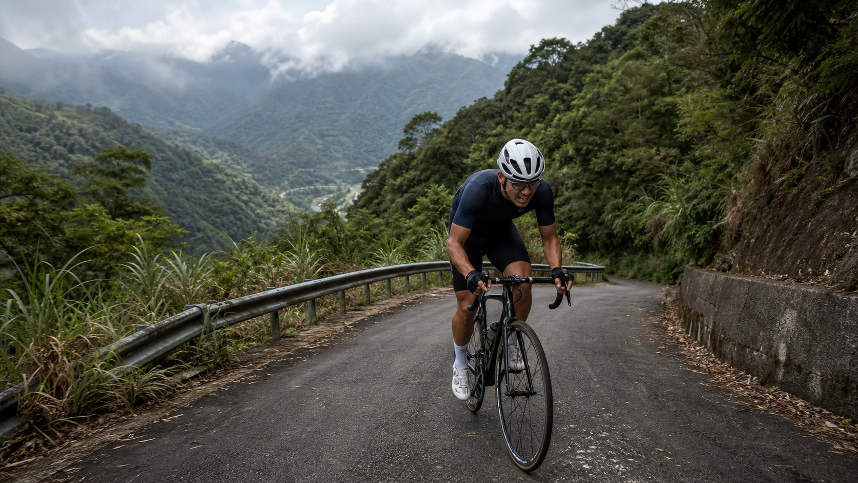
Battle Guide for Tai 116 Baling Road: A Short, Steep 7 km Climb at 8.1% Average Grade
It’s not long, but every meter has to be earned with your legs. Tai 116 Baling Road is one of the few “short but fierce” climbs around the Northern Cross-Island Highway. At just 7 km, the length seems approachable, but the 8.1% average grade has broken many riders who thought their legs were up to the task. This guide lays out the data, gear, nutrition, and time references so you can get your mind right before you even roll out.
1. Route Overview and Data Analysis: Let’s Clear Up the Contradictory Numbers First
Tai 116 County Road—most riders simply call it “Baling Road”—is located in Fuxing District, Taoyuan City, hugging the mountainous terrain around the Northern Cross-Island Highway (Provincial Highway 7). It’s a branch mountain road leading into the Baling area. On Strava, this route is classified as a category 3 climb. Against the international climb grading system, that rating is already enough to make most amateur riders feel serious burning in their legs—not just “a little out of breath.”
Let’s be upfront about one thing this article needs to honestly address: the route database lists the distance as 6,995.9 meters, which converts to roughly 7.0 km; the average grade is listed as 8.1%; but the total elevation gain is listed as 1,063.1 meters. If you simply do the middle-school math, 7 km multiplied by an 8.1% average grade should theoretically produce only about 567 meters of climbing—a gap of nearly 500 meters from the database’s 1,063.1 meters, a difference of almost double. Conversely, if the elevation gain really were 1,063.1 meters, then over a 7 km distance, the average grade would need to be close to 15.2% to make sense—not the 8.1% listed in the database.
These two sets of numbers are clearly contradictory and cannot both be true. As responsible route reviewers, we’re not going to pick one number and stubbornly treat it as gospel. Instead, we’ll be honest with our readers: this is most likely the result of discrepancies in how the original route database measured elevation gain, or GPS elevation errors caused by signal reflection and multipath effects in mountainous terrain. This situation is not uncommon in route databases for Taiwan’s mountain roads—valley terrain in particular tends to block GPS satellite signals, causing elevation data to jump or misreport climbing.
Therefore, for the rest of this guide, when describing grade tactics and perceived exertion, we’ll use “7.0 km, 8.1% average grade” as the primary reference, because the 8.1% figure is relatively consistent with the Strava category 3 rating and serves as a reasonable baseline. As for the 1,063.1-meter elevation gain figure, we’ll keep it for reference but clearly remind all riders: for actual climbing, defer to your own on-site GPS recording and your bike computer’s accumulated ascent—don’t treat any single database number as absolute truth. If your watch shows a climb that differs from both 567 meters and 1,063.1 meters after you finish, don’t be too surprised; that’s a common measurement error range for short mountain segments.
From a grade-distribution perspective, an 8.1% average over just 7 km puts this firmly in the “short and steep” category. Compared to the more famous Yufeng-Yulao segment (average grade around 8.2%), also in Fuxing District, Taoyuan, Tai 116 is nearly identical in grade percentage but significantly shorter. That means the intensity density per kilometer is higher—in other words, you can’t spread your effort across a longer distance and pace yourself gradually the way you can on Yulao. Tai 116 demands that you push your body into the high-intensity zone quickly and hold it there until the finish. This route characteristic is exactly why it’s become one of the top choices for advanced riders looking for “steep-climb interval training.”
Tai 116 passes through several Atayal tribal communities. The road is narrow with many curves, and the mountains around the Northern Cross-Island Highway are prone to fog, occasional rockfall, and slippery surfaces—all environmental variables you must factor into your planning. This route is better suited to riders who already have solid climbing experience and understand their own cadence rhythm and heart-rate response. If you’re a complete beginner with no climbing experience, we recommend building up experience on gentler routes first before taking on Tai 116—it’ll be safer and more enjoyable.
2. Segment-by-Segment Strategy from Start to Finish: Breaking 7 km into Digestible Chunks
Facing a short mountain road with an 8.1% average grade, the worst thing you can do is “ride by feel.” Charging in blindly will likely blow you up by the middle section, leaving you to push your bike or crawl along at a painfully slow pace—which ends up slowing your overall time and crushing your morale anyway. We recommend splitting the 7 km into three or four mental segments to manage your pace.
Segment 1 (Start to ~1.8 km): Warm up the legs, not the heart. This section is usually the relatively “friendly” lead-in of the entire route. The grade is already climbing, but it’s not yet enough to push most riders straight into their maximum heart-rate zone. The focus here isn’t speed—it’s waking your body up and stabilizing your cadence in the range you’re most comfortable with for climbing (most riders fall between 70 and 85 rpm), while also watching your heart-rate curve to avoid charging into the anaerobic zone right from the start. A lot of riders go too fast here because it feels like “this isn’t so bad,” and then pay for it later—that’s the number one tactical mistake on Tai 116.
Segment 2 (~1.8 to 4 km): The real fight begins. This is usually the core section where the grade is most concentrated and where willpower is tested hardest. The sustained steepness will naturally drop your cadence. Don’t stubbornly fight the grade with high cadence—shift into an easier gear and bring your cadence back to a range you can sustain. That’s far smarter than grinding along at low cadence and high torque. If this section has tree cover, consider yourself lucky, but there are plenty of exposed stretches around the Northern Cross-Island Highway where the sun beats down directly. Riding here at midday in summer, the perceived temperature can differ significantly from the actual air temperature, so keep up with your hydration schedule.
Segment 3 (~4 to 6 km): The zone where your mind is most likely to break. By this point, most riders’ thighs are burning with noticeable fatigue buildup. If the grade doesn’t let up significantly here, it’s very easy to start thinking “maybe I should just walk.” For this section, we recommend a mental tactic of “setting small goals within each segment”—use utility poles, road signs, or curves as visual short-term finish lines, telling yourself “just make it to that point,” rather than dwelling on discouraging distance concepts like “still two or three kilometers to go.”
Segment 4 (~6 to 7 km, the finish): Final sprint or survival mode. It depends on how your day is going. If you managed your pace well through the first three segments and still have something left, you can try a small sprint to close it out. But if you’re already at your limit, the goal here is simply “finish safely—no crashes, no cramps.” The finish of Tai 116 typically doesn’t have a particularly obvious landmark marking the line, so we recommend relying on the route-end alert on your own device, or confirming the route details in advance, to avoid riding past it or stopping early.
Overall, the combination of 7 km and an 8.1% average grade means there’s almost no genuinely long, easy stretch where you can truly catch your breath. That’s why, despite the short distance, your finish time and perceived exertion can rival certain mid-distance climbs of 12 to 15 km.
3. Gear Ratio and Equipment Recommendations: For Short, Steep Climbs, the Biggest Mistake Is Not Having a Light Enough Gear
Facing Tao 116, which has an average gradient of 8.1% and may include sections that are even steeper, your gear ratio setup is absolutely one of the key factors that determines whether your ride feels exhilarating or agonizing. Many cyclists who are used to riding gentle slopes or flat roads tend to set up their gearing for speed. When they hit a short, steep climb like this, they suddenly find themselves with “no gear to use” and are forced to grind at an extremely low cadence. This not only hurts your knees, but also easily depletes the glycogen in your muscles midway through the climb.
Below are suggested gear ratio configurations for different bike types and rider strength levels:
| Rider Level | Recommended Chainring | Recommended Cassette | Notes |
|---|---|---|---|
| Advanced/Competitive | Standard crankset 50/34T or 52/36T | 11-28T or 11-30T | Has decent climbing ability, but it’s still advisable to keep a lighter gear option for short, steep climbs |
| General recreational rider | Compact crankset 50/34T | 11-32T or 11-34T | A safe setup for most riders, preventing premature exhaustion |
| Those with less climbing experience | Compact crankset 50/34T | 11-34T or higher, or opt for a cassette with a wider range | Better to have a gear that’s too light and spin a higher cadence than one that’s too heavy and end up with legs like jelly |
| E-bike / those planning a leisurely challenge | Follow the bike manufacturer’s original configuration | Adjust assist level according to the e-bike mode | For short, steep climbs, it’s recommended to increase the assist level on an e-bike to handle the continuous steep sections |
Beyond gear ratios, the following equipment details are also worth confirming in advance:
Tire Pressure and Width: Mountain roads can occasionally have potholes or loose gravel. Avoid inflating tires to too high a pressure to prevent a loss of grip. A tire width of 25C or wider is recommended to balance comfort and traction.
Brake System Condition: The descent on Tao 116 also has a significant gradient. Before setting off, be sure to check the brake pad wear and whether the brake fluid/cables are functioning properly. Continuous descents in the mountains put a heavy load on the braking system. A poorly maintained brake system is a very dangerous hazard on steep slopes.
Bike Weight and Load Management: Short, steep climbs are particularly sensitive to bike weight. If it’s not necessary, try to minimize the weight of extra food or gear you carry. Just bring a reasonable amount of water and snacks; there’s no need to burden yourself with too much for a 7-kilometer route.
Cycle Computer or GPS Device: Given the aforementioned discrepancies and concerns regarding the climbing data for this route, it’s recommended to record your ride with GPS from start to finish. This allows you to compare your data with database figures afterwards, accumulate your own reliable data, and use it as a reference for planning future training intensity.
4. Nutrition and Hydration Management: Short Distance Doesn’t Mean You Can Be Careless
Many cyclists have a common misconception: “It’s only 7 kilometers, so I probably don’t need to fuel up, right?” This way of thinking is actually quite dangerous on a route like Tao 116, which has a high density of steep gradients. Although the distance is short, because the gradient is steep and the intensity is high, your body burns energy and loses fluids at a rate per unit of time that can be much faster than riding a 20-kilometer route on a gentle slope.
Preparation Before Departure: It’s recommended to have completed your baseline hydration and electrolyte intake before you even reach the starting point. Don’t wait until the climb begins to scramble. If the temperature is high or humidity is significant that day, consuming an electrolyte drink 30 minutes to an hour before departure can effectively reduce the risk of mid-ride cramps.
Pacing Your Intake During the Ride: Since there are almost no truly flat sections where you can safely drink water, it’s recommended to take small sips at points where the gradient eases slightly, visibility is more open, and the road surface is more stable. Avoid drinking while distracted on steep corners or in areas with poor visibility, as one-handed handling could lead to a loss of balance and a crash. For solid food, because the intensity is high on short, steep climbs, your digestive system’s capacity decreases. It’s best to choose gel-type nutrition or sports candies that are easy to consume and absorb, avoiding solid food during the ride to prevent digestive discomfort.
Electrolytes and Cramp Prevention: An 8.1% average gradient means your quadriceps and calf muscles will be under sustained high-tension contractions. In this state, electrolyte loss is rapid, making it a prime scenario for cramps. It’s recommended to carry a small packet of electrolyte supplement or salt tablets. If you feel a slight twitch in your calf or thigh, replenish immediately and ease off the pace, rather than pushing through at full power.
Recovery Nutrition After the Ride: After completing the challenge, your body will be in a state of muscle micro-damage and energy depletion. It’s recommended to consume a meal or recovery drink combining adequate protein and carbohydrates within the golden 30-minute to 1-hour recovery window, and to continue hydrating to help your body repair and flush out metabolic waste.
It’s important to note that the availability of shops and supply points along Tao 116 and in the surrounding Baling area can change over time depending on business hours. It’s strongly recommended that cyclists plan a complete fueling strategy before departure, bring ample water and snacks, and not rely entirely on finding stores along the way. The safest approach is to base your decisions on the actual on-site conditions.
5. Weather and Seasonal Recommendations: Don’t Underestimate the Climatic Characteristics of the Northern Cross-Island Mountain Area
The mountainous terrain surrounding the Northern Cross-Island Highway, including the Fuxing District where Tao 116 is located, features a typical landscape of alternating valleys and ridgelines. This type of terrain has a significant impact on weather patterns, and cyclists must factor climate considerations into their trip planning.
High-Risk Period for Afternoon Thunderstorms: During the summer months (roughly May to September), the mountainous areas of north-central Taiwan are prone to convective afternoon thunderstorms. These weather systems are characterized by their sudden and intense onset. Once rain falls on mountain roads, wet surfaces combined with poor visibility pose a significant threat to riding safety on steep sections. It’s recommended to plan your departure for the early morning or morning hours, aiming to complete the challenge or at least descend to a relatively safer section before the typical afternoon thunderstorm window.
Mountain Fog and Visibility Issues: Due to changes in altitude and humidity, the mountain roads around the Northern Cross-Island area are prone to fog in the early morning or afternoon. Poor visibility increases risk on both ascents and descents. Some sections of Tao 116 already have limited visibility around corners, so when fog sets in, it’s advisable to slow down and turn on your bike lights to increase your visibility to others.
Winter Low Temperatures and Wet Roads: In winter, mountain temperatures are significantly lower than in the plains. Combined with occasional rain, wet roads and cold temperatures negatively affect muscle flexibility and tire grip. If you plan to tackle this route in winter, be sure to dress warmly and extend your warm-up time, allowing your body and muscles to fully adapt to the cold environment before starting high-intensity climbing.
Wind Direction and Terrain Effects: Valley terrain can sometimes produce localized topographical wind effects. Wind strength can noticeably increase, especially on ridgelines or in open areas. This is an additional variable to watch out for on descents, particularly for riders with a higher center of gravity or those whose bike-handling skills are not yet fully refined.
The overall recommendation is that unless you have considerable experience riding in mountainous terrain, try to avoid challenging steep sections like Tao 116 in the afternoon or in rainy conditions. Departing in the early morning or morning hours when the weather is stable and visibility is good is a relatively safer and more comfortable option. Weather conditions can change rapidly, so be sure to check the latest forecasts and mountain area special advisories from meteorological authorities before you leave, and make your final decision based on the actual on-site weather.
6. Common Mistakes and DNF Risks: Pitfalls You Must Avoid
Observing the experiences of many riders tackling similar short, steep climbing routes, several common mistakes can be identified that frequently lead to mid-ride abandonment (DNF) or a significantly diminished experience.
Mistake 1: Starting too fast, leaving nothing for the latter half. As mentioned in the section-by-section strategy, the first section has a relatively gentle gradient. Many riders, feeling “it’s not so bad,” sprint at an intensity beyond their capabilities. As a result, by the time they reach the true steep core of the second section, their heart rate is already near its limit, and their muscle energy is prematurely depleted. The rest of the climb becomes a battle of pure willpower, or even a forced dismount.
Mistake 2: Incorrect gear ratio setup, forcing brute force against the slope. Without a sufficiently light gear ratio, facing an 8.1% average gradient with potentially steeper sections, riders are forced to pedal with extremely low cadence and high torque. This riding style places immense stress on the knee joints, increasing the risk of overuse injuries over time. In the short term, it accelerates lactic acid buildup, leading to premature exhaustion.
Mistake 3: Ignoring fueling timing, always replenishing a step too late. Many riders are accustomed to “drinking only when thirsty, eating only when hungry.” However, during high-intensity climbing, the body’s signals are often delayed. By the time you actually feel fatigue or early signs of cramping, your body is already in an energy and fluid deficit. At that point, fueling is often too late to reverse the decline.
Mistake 4: Insufficient mental preparation, misled by the short distance. The number “only 7 kilometers” can easily lead riders to underestimate the route’s actual intensity. This is especially true for those accustomed to long, gradual climbs, who may approach this short, high-gradient-density challenge with incorrect mental expectations, leading to premature abandonment due to psychological letdown.
Mistake 5: Ignoring weather and road condition risks, recklessly challenging in poor conditions. As mentioned in the previous section, risks such as afternoon thunderstorms, fog, and slippery roads are prevalent. Without proper trip planning and risk assessment, heading up the mountain in bad weather not only makes the experience more physically miserable but also significantly increases the risk of crashes or getting lost.
Avoiding these common mistakes, combined with the section-by-section strategy, gear ratio recommendations, and fueling rhythm mentioned earlier, can greatly reduce the probability of giving up midway or encountering accidents, bringing the entire challenge closer to your original goals.
7. Reference Target Times for Riders of Different Levels
As publicly available completion data for Tao 116 is currently limited, the following time references are compiled based on the route’s intensity characteristics (8.1% average gradient, 7 km distance) and cross-referenced with typical performance ranges of general riders on similar gradient-density routes (such as short, steep climbs like Yufeng Yulao). These are intended only as a rough guideline. Actual times can vary considerably depending on individual daily condition, weather, equipment, and other factors. Please do not treat these figures as absolute standards.
| Rider Level | Estimated Completion Time Reference | Perceived Intensity Description |
|---|---|---|
| Competitive level / Specialized climber | Approximately 25 to 32 minutes | Near lactate threshold intensity for most of the ride, still retaining tactical control |
| Advanced rider (regular climbing training) | Approximately 32 to 42 minutes | Noticeably difficult in the middle and latter sections, requires active pace management to avoid blowing up |
| General recreational rider (basic cycling habits) | Approximately 42 to 55 minutes | Overall intensity is high; a light gear ratio and segmented rest strategy are recommended |
| Limited climbing experience | Approximately 55 minutes or more, may even need mid-ride breaks | Recommended to build climbing experience before attempting; ride within your limits |
It should be specifically noted that this time reference table represents a comprehensive, approximate range, not precise statistics derived from extensive real-world data on Tao 116 itself. Riders should treat it as a mental preparation tool for “which tier I might fall into,” rather than an absolute benchmark for direct comparison or ranking against other riders. What truly matters is understanding your own fitness level, setting a reasonable personal goal, and completing the ride safely.
8. Pre-Ride Training Recommendations: How to Prepare for a Short, Steep Climb
To successfully conquer a short, high-intensity route like Tao 116 with an 8.1% average gradient, targeted training before the event or ride will be significantly beneficial.
Interval training takes priority over long, slow distance. Since Tao 116 offers almost no true recovery sections, it’s recommended to incorporate more high-intensity interval workouts into your pre-ride training. For example, perform 3 to 8-minute high-intensity climbing intervals on a trainer or a gentle slope to simulate the sustained high-power output required on Tao 116. Compared to simply accumulating long mileage, this is more effective at improving your ability to handle such short, steep climbs.
Practice transitioning between standing and seated climbing. When facing sustained steep gradients, switching between standing out-of-the-saddle efforts and seated climbing allows different muscle groups to share the load alternately, delaying fatigue in any single muscle group. Before the ride, practice the timing and rhythm of switching between these two positions on training roads with similar gradients to find your most efficient transition pattern.
Core and lower body strength training. Short, steep climbs demand high levels of core stability and lower body strength. It’s recommended to incorporate weight training or bodyweight exercises to strengthen the quadriceps, glutes, and core muscles. The strength reserve in these muscle groups directly translates to how long you can sustain effective power output when facing steep slopes.
Alternative training simulating the route’s gradient. If there are no training routes with similar gradients near your home, make good use of the gradient simulation function on a bike trainer, or find alternative local roads with a similar gradient range (around 7% to 9%) for targeted training, allowing your body to adapt in advance to this sustained high-tension pedaling sensation.
Building a foundational aerobic base remains important. Although interval and strength training are emphasized, these are all built upon a certain aerobic foundation. You should still maintain a regular aerobic training frequency before the ride to ensure your cardiorespiratory system has sufficient basic capacity to support the quality and recovery of high-intensity interval training.
It is recommended to start adjusting your training content specifically at least four to six weeks in advance, giving your body ample time to adapt and improve. Last-minute, crash-course training often yields limited results and may even increase the risk of injury due to improperly arranged training intensity.
9. Quick Q&A
Q1: Does Tao 116 Baling Road really have an elevation gain of 1063.1 meters?
A: This is the figure recorded in route databases. However, based on the 7 km distance and 8.1% average gradient, the theoretical elevation gain should be closer to around 570 meters. There is a clear discrepancy between the two figures, likely related to the elevation measurement method or GPS altitude errors. It’s recommended to enable your own GPS recording device during the ride and rely on on-site measured data rather than completely trusting a single database figure.
Q2: Can a beginner take on Tao 116?
A: An 8.1% average gradient is quite intense for a beginner with no climbing experience, potentially leading to frustration or even safety concerns. It’s recommended to first gain experience on routes with gentler gradients and moderate distances. Only after confirming your heart rate response and feel for climbing should you consider tackling a short, steep route like this.
Q3: How much water should I bring?
A: Although the total distance is only 7 km, the rate of fluid loss during high-intensity climbing can be comparable to longer, gradual rides. It’s recommended to carry at least one bottle of 500 ml or more of water or electrolyte drink, and to ensure you are adequately hydrated before starting. Don’t wait until you’re thirsty to react.
Q4: Are there any supply stations or shops along Tao 116?
A: There are indeed some businesses scattered around Baling and the surrounding Northern Cross-Island Highway area. However, their actual operating status, locations, and hours can change over time. It’s recommended not to rely entirely on roadside supplies. Bringing your own ample water and portable food before departure is the safer approach. Please refer to the on-site conditions for actual circumstances.
Q5: What time of day is best to challenge Tao 116?
A: Considering that the mountainous area around the Northern Cross-Island Highway is prone to afternoon thunderstorms in summer and has a high probability of fog, it’s recommended to depart in the early morning to late morning hours. On one hand, the temperature is cooler, reducing physical strain; on the other hand, it helps you avoid the high-risk period of more severe afternoon weather changes.
10. Transportation, Itinerary Planning, and Summary
For riders coming from Taoyuan City to the Baling area in Fuxing District, where Route 桃116 is located, most will choose to ride along the Provincial Highway 7 (Northern Cross-Island Highway) as a connecting route, or drive with a bike rack to transport their bike to a point near the start, then take on a one-way or out-and-back challenge. Since the Northern Cross-Island Highway itself involves considerable distance and elevation gain, we recommend riders incorporate the 桃116 challenge as one segment of the overall Northern Cross-Island itinerary, and plan ahead for full补给, rest, and return arrangements—don’t expend all your energy on this short, steep climb and leave yourself stretched thin for the rest of the ride.
If you’re planning a dedicated one-day trip specifically for the 桃116 challenge, we suggest setting a generous departure time, allowing ample warm-up time and post-ride recovery time. After all, this is a high-intensity, short-distance route, and your body needs sufficient buffer time to absorb the fatigue accumulated from the climb.
In summary, 桃116 Baling Road is a short, steep climb that “doesn’t intimidate with distance, but intimidates with intensity.” The combination of 7 kilometers and an average 8.1% gradient makes it an excellent testing ground for advanced riders to assess their climbing ability and conduct specialized steep-gradient training. As for the discrepancy between the 1,063.1-meter elevation gain figure and the 8.1% average gradient in the route database, we recommend riders approach it with an open but cautious mindset—respect the presentation of the raw data, but also understand the inherent limitations of GPS measurement in mountainous areas, and ultimately defer to your own device’s recording during the actual ride. With a sufficiently low gear ratio, adequate supplies, sound weather judgment, and solid pre-ride training, 桃116 will be a route that leaves you with a great sense of accomplishment after finishing—and one you’ll want to brag to your fellow riders about, saying “I made it through.” We wish all riders a safe and smooth completion of this tough short-steep-climb battle.
Related Reading
- Seven Kilometers of Steep Slope, the Silence of a Whole Mountain: The Northern Cross-Island Branch I Encountered on 桃116 Baling Road
- Northern Cross-Island Baling to Mingchi Practical Guide: An Endurance Test of 18.5 km, 3.2% Average Gradient, and an Estimated 592-Meter Climb
- Balaka Road Guide: 10.2 km of Yangmingshan’s Classic Gentle Slope, Breaking Down the Real Difficulty of “The Last Finger of the Rulai Palm”
- Sanxia North 113 Dongyan Bridge Practical Guide: Don’t Be Fooled by the “6.7% Average Gradient”—This Road Hides a 12%-Grade Killer Move
台北闊瀨陡坡 騎旅 / 日本單車雜誌編輯車友臨時加入!/ 髮香才是最強的 / feat. 北迴歸線小隊 / 公路車 CT Yeh
6 個月前
滿滿的人還有妹子的香,拉拉山上巴陵挑戰行,絕美山陵空拍!feat. JJSC | 公路車 | CT Yeh
3 年前
西進武嶺 8000名單車友數據分析 PART1 | 從新手到高手數量/瓦數/推力比/FTP推力比/功率計使用率 大解析 | 公路車 | CTYeh
5 年前
#北橫 + #北進武嶺 最硬的員工旅遊 EP1 | #公路車 #拉拉山 | 明池 | 武嶺 | 武陵農場 | 雲海 | Taiwan Cycling Route Wulin
6 年前
大禹嶺 到 武嶺牌樓 全程前後實況錄影 | 北進武嶺 | 東進武嶺 | KOM | 訓練台 | 坡度分析 | Taiwan KOM Last 10 km HARD | 公路車
6 年前
萬年峽谷! 30% 超激陡坡 里佳部落DAY2 還是很硬! | 公路車 | CT Yeh
3 年前
一日北高常見問題大集合 | 攻略 | 路線 | 訓練 | 補給 | 自行車 單車 | 一日雙城 | 雙塔 | TWB北高360 | 屁股痛
6 年前
單車 梅山36灣 坡度介紹 路段介紹 空拍 (相關遊記影片,請參考說明或我的頻道喔,歡迎訂閱)
6 年前