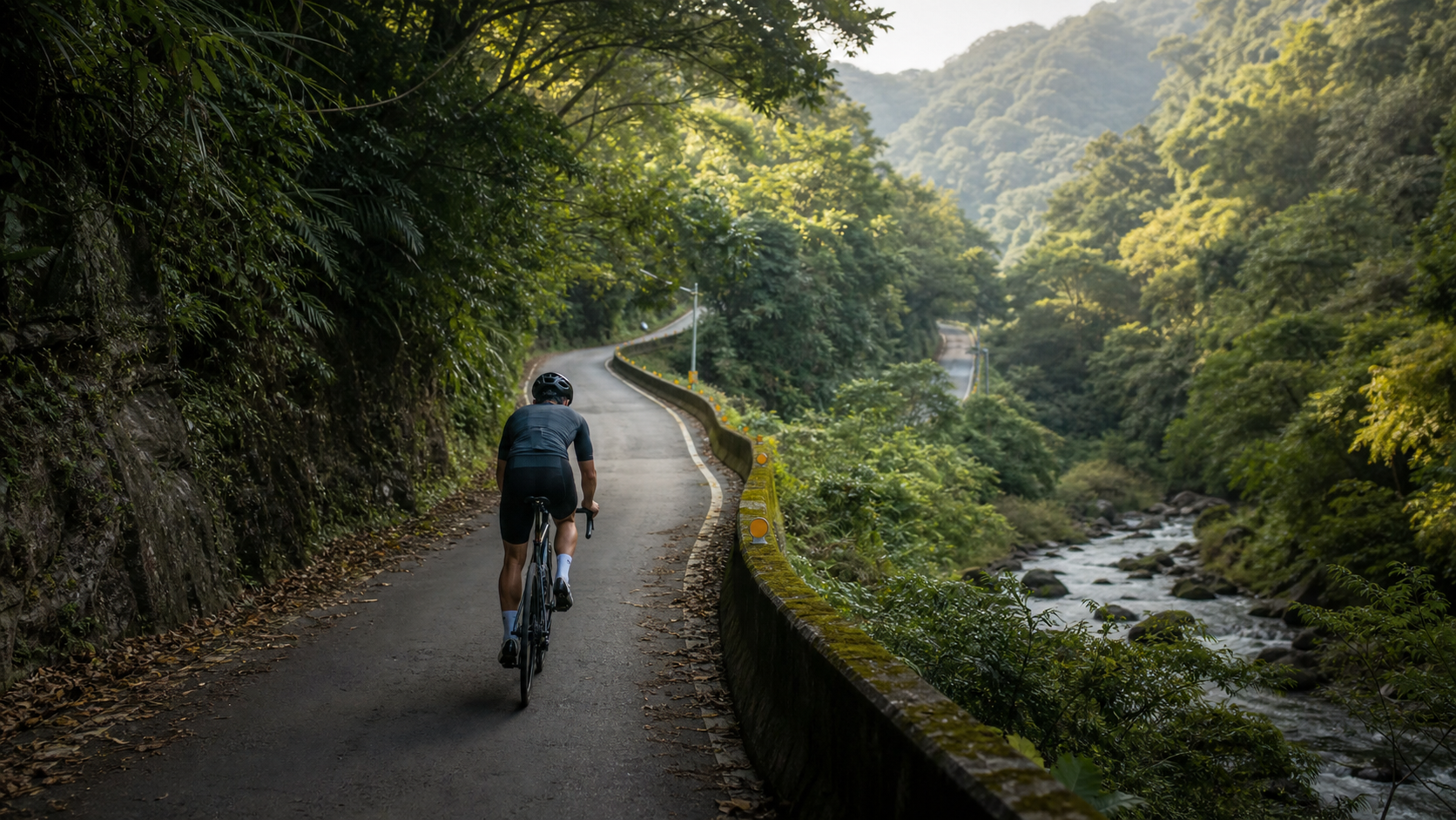
Tonghou Forest Road Practical Guide: Reading the Real Terrain Behind 12.07 km and 1.8% Average Grade
“An average grade under 2% sounds like an easy road, but anyone who has actually ridden it knows that the difficulty of Tonghou Forest Road isn’t in the grade numbers—it’s in the relentless accumulation of rolling climbs.”
New Taipei City’s Wulai District Tonghou Forest Road (Strava segment ID 17117690) is a forest road route that carries considerable weight among cyclists in northern Taiwan. It is the access road leading to the western section of the Tonghou Cross-Ridge Historic Trail, following the Tonghou Creek upstream and eventually connecting toward the saddle of the Xueshan Range. This article focuses on data analysis, segment-by-segment tactics, and gear and supplies, laying out the route’s true difficulty in plain terms.
Route Overview and Real Data Analysis
Let’s start with the hard numbers:
| Item | Value |
|---|---|
| Distance | 12,066.2 meters (approx. 12.07 km) |
| Total elevation gain | 428.8 meters |
| Average grade | 1.8% |
| Location | Wulai District, New Taipei City, heading up along Tonghou Creek |
| Route type | Access road, part of the western section of the Tonghou Cross-Ridge Historic Trail |
This route’s data combination is a classic case where many beginners misjudge the difficulty. If you look only at the “1.8% average grade” figure, your instinct tells you this is an almost flat route—but the 428.8-meter total elevation gain tells a completely different story. Working backward with simple math: 12,066.2 meters multiplied by 1.8% gives a theoretical climb of only about 217 meters, a gap of nearly double compared to the actual stated 428.8 meters.
This gap isn’t a data error—it’s a real phenomenon caused by terrain characteristics. Average grade is a linear simplification derived from “total elevation gain ÷ horizontal distance,” which assumes the entire route climbs steadily in one direction; but Tonghou Forest Road is actually a route of gentle climbing interwoven with multiple rolling sections—along the way you repeatedly approach, cross, or ride alongside the banks of Tonghou Creek, with the terrain winding up and down along the valley. You’ll experience a gentle climb, then a short descent, then another rolling climb, and so on. The total elevation gain recorded by GPS adds up every upward segment in these “ups and downs,” so the final figure ends up far higher than a simple linear calculation would suggest.
What does this mean practically for riders? Tonghou Forest Road is not a route where you can cruise steadily the whole way—it’s a long forest-road ride that demands constant pace adjustments and responses to changing terrain. If you see the 1.8% average grade and assume you can ride the entire route in the big ring with a high cadence, you may find yourself caught off guard by the successive small rollers starting in the middle section, throwing your energy management completely out of whack.
This route characteristic—where the average grade figure diverges significantly from actual feel—is actually a common phenomenon among many riverside forest roads in Taiwan, not unique to Tonghou Forest Road. Constrained by water erosion and geological conditions in valley terrain, access roads often cannot take a purely linear climbing path; instead, they must follow the riverside terrain, looping repeatedly, crossing tributaries, and avoiding landslide-prone or unstable sections, gradually stacking up into a passable road. As a result, the GPS total elevation gain on this type of route is often far higher than the theoretical value derived from the formula—you can think of it as the road’s “actual climbing workload” being much more substantial than the surface-level average grade suggests. For riders who habitually use average grade to quickly filter route difficulty, Tonghou Forest Road serves as a good reminder: when assessing a route’s true difficulty, total elevation gain and distance need to be considered alongside average grade—especially for riverside forest roads and cross-ridge historic trails.
Additionally, in terms of route positioning, Tonghou Forest Road is the ridable western section of the entire Tonghou Cross-Ridge Historic Trail (a well-known trail connecting Wulai’s Xiaoyi to Yilan’s Jiaoxi, approximately 30 km in total length), classified as an access road passable by bicycles and some vehicles; beyond the end of the forest road, the trail transitions to a hiking section, continuing upstream along Tonghou Creek, crossing the saddle of the Xueshan Range, then descending to the Xiaojiaoxi area on the Yilan side. This also means the 12.07 km cycling section discussed here is only the “introductory chapter” of the entire historic trail. If you ever want to challenge a full traverse of the trail on foot, Tonghou Forest Road is an excellent precursor route for familiarizing yourself with the terrain and building geographic awareness by bike.
Start-to-Finish Segment Guide: Breaking 12 km into Four Management Units
At 12 km in length, without a segment-management mindset, it’s easy to feel psychologically like “there’s no end in sight” and lose steam early. Below is a four-part breakdown to help you build a rhythm map (for actual terrain undulations, please refer to on-site conditions and GPS tracks).
Segment 1 (approx. 0–3 km): Gentle start, establish endurance rhythm
The entrance section of the forest road is typically milder in grade and is the critical zone for establishing your endurance rhythm for the entire ride. Don’t approach this section with a short-climb mentality—a 12 km forest road is an endurance event, not a sprint. It’s recommended to start at an intensity you can sustain for over an hour from the very beginning; better to be conservative than to go out too hot.
- Keep cadence slightly above your usual range, keeping your legs spinning smoothly rather than grinding a heavy gear
- Keep heart rate in the aerobic zone (primarily Zone 2), since there’s still a long way to go
- Watch for slippery or gravelly surfaces along the riverside sections; this type of access road has more variable conditions than city roads
This section is also a good time to establish a “pacing psychological anchor.” At the entrance, take 30 seconds to a minute to observe the road surface material, the initial grade angle, and the surrounding vegetation density, building preliminary mental preparation for the riding environment ahead. Many failed attempts on long forest-road routes aren’t actually due to insufficient physical fitness—they’re caused by uncertainty (“how much farther, what’s the terrain like ahead”) draining too much mental focus. By knowing the rough segment outline of the route in advance (like the four-part breakdown in this article), you can keep encouraging yourself along the way by tracking “how many fractions are done.” This kind of mental rhythm management is no less important than physical energy distribution for long forest-road riding.
Segment 2 (approx. 3–6 km): Rolling terrain, testing your rhythm adjustment ability
This is the core section where “the average grade figure lies.” The terrain begins to feature continuous small rollers as it winds along Tonghou Creek—climb into descent, descent back into climb. If your mindset is still stuck on “this is a flat route,” the repeated rhythm shifts can easily throw off your breathing.
Practical advice:
- Don’t completely coast on the descents; maintaining light pedaling keeps your legs warm and lets you react faster when the next climb comes
- Control your output on the climbs, avoiding a sprint mentality on every small rise, or you’ll be severely depleted by the end of 12 km
- Road surface quality may vary depending on forest-road maintenance conditions; keep an eye out for potholes, rocks, or slippery mossy areas
This rolling terrain also demands more from your shifting technique—rather than stubbornly holding one gear to grind through every undulation, build the habit of “anticipatory shifting”: shift down one to two seconds before entering each small climb, completing the gear change before the drivetrain takes high torque. This effectively reduces the risk of chain skip or breakage while also making it easier to keep cadence in a stable range. Conversely, shift up early before descents to avoid cadence spiking suddenly as speed builds, losing effective control of the pedals. This “one step ahead” shifting rhythm is a key detail that determines your pedaling efficiency and comfort in continuous rolling terrain—worth practicing repeatedly until it becomes muscle memory.
Section 3 (Approx. 6–9 km): Deep Creek Section, Elevation Gain Becomes Apparent
As you continue deeper into the forest road, you’ll notice the surroundings gradually shift from the relatively open entrance area to a more rugged mountain terrain closer to the creek, with denser tree cover. The views along this section will vary with the terrain. While the increased shade helps with cooling, the road surface may also be wetter, requiring more attention to tire grip.
In terms of feel, this is the section where the “cumulative elevation gain” of the entire ride truly takes effect—the rolling climbs from the previous sections will begin to build fatigue in your legs. Even if individual slopes don’t look steep, after riding over 6 km of undulating terrain, the toll on muscular endurance will be more significant than the numbers on paper suggest. It’s recommended to start taking in nutrition moderately from this point (see the nutrition section below) to avoid running out of both blood sugar and energy simultaneously.
Because this section goes deep into the creek valley, the ambient temperature is usually noticeably cooler than in the urban area or the entrance section. Especially in densely shaded areas, the perceived temperature may drop by more than two to three degrees Celsius. This is a major advantage for riding during hot summer hours, effectively reducing the risk of heatstroke or heat exhaustion. However, if you enter this section during an already cool season (e.g., a winter morning), be sure to keep warm to avoid a rapid drop in body temperature affecting muscle performance and reaction speed. Air humidity typically increases noticeably here; fogged-up lenses and sticky skin are common sensations. It’s recommended to wear quick-dry cycling clothing and bring a small towel to wipe away sweat and clear your lenses, maintaining clear vision while riding.
Section 4 (Approx. 9–12.07 km): Approaching the Endpoint, Managing Remaining Energy and Turnaround Planning
For this final section, special attention should be paid to preserving energy for the turnaround point. If your plan is to return the same way (the route arrangement for most riders), remember this: reaching the endpoint does not mean the ride is over—you still need to save enough energy for the 12 km return trip. Many riders use up ninety percent of their energy by the one-way endpoint, making the return journey exceptionally tough, even forcing them to stop and rest multiple times.
Suggested strategy:
- In the last 2–3 km before reaching the endpoint, proactively slow down and bring your heart rate into a sustainable range
- Upon reaching the turnaround point, rest, refuel, and stretch thoroughly before starting the return
- For the return trip, note that the descents on the way out will become climbs on the way back; remember to reserve corresponding energy and mental preparation
The area around the turnaround point is also typically an excellent spot to enjoy the scenery of the upper Tonghou Creek valley. The creek water is crystal clear, and the banks are densely vegetated—a place where many riders deliberately stop to take photos and rest. It’s recommended to treat the final stretch before the turnaround as serving the dual purpose of a “tactical finish” and a “scenic reward”—by slowing down to conserve energy, you also give yourself the leeway to properly appreciate the valley views earned through the tough climbing, rather than burying your head and riding the whole way, missing the scenery along the route. After all, the value of a long forest-road route lies not only in the distance completed and elevation numbers; the scenery along the way and the physical and mental experience during the ride are equally important parts of what makes this trip worthwhile.
Gear Ratio and Equipment Recommendations
For a long-distance forest road route with varied terrain, equipment setup involves clearly different considerations compared to short-distance urban climbing routes:
- Gear ratio setup: It’s recommended to use a wider-range rear cassette (e.g., 11-32T or 11-34T) to allow more flexible cadence adjustments on continuous undulating terrain, without needing to frequently switch between the big and small chainrings
- Tire selection: Forest road surface conditions are usually more complex than urban asphalt, with possible gravel, potholes, and slippery sections. It’s recommended to choose tires with better grip and higher puncture resistance. Road cyclists, if aware of poor road conditions, may also consider switching to wider tires (28c or above) for increased stability and comfort
- Bike suitability: This route can be handled by road bikes, gravel bikes, or mountain bikes. However, if you’re certain the road surface is in poor condition (e.g., after typhoon season when the roadbed may be damaged), a gravel bike or mountain bike will provide a greater safety margin
- Brake system: Long forest roads have continuous ups and downs. It’s recommended to confirm your brake pads are in good condition, especially for handling the continuous descents on the return trip—braking performance is directly related to riding safety
Equipment checklist reminders:
- Since the forest road goes deep into the mountains, mobile phone signal may be unstable or even lost. It’s recommended to inform family or friends of your ride plan and consider bringing a power bank
- Puncture repair tools, spare inner tubes, and a pump are a must—calling for roadside assistance in the mountains is time-consuming and difficult
- Front and rear lights are recommended as standard equipment, even if departing during the day; if the ride is delayed and you end up riding in the dark, lights are basic safety gear
Nutrition and Hydration Strategy
For a 12 km forest road route with 428.8 meters of elevation gain, plus the out-and-back plan, the total riding distance may exceed 24 km. Depending on individual fitness, riding time is roughly estimated at 1.5–3 hours (excluding rest time). Nutrition strategy needs more careful planning than for shorter routes:
- Before departure: Ensure adequate carbohydrate and fluid intake. Supply points in the mountains are scarce, so be mentally prepared to be “self-sufficient”
- Water bottles and supplies: It’s recommended to carry at least two bottles’ worth of water; increase the amount if the weather is hot. Energy gels, portable snacks, and electrolyte supplements are all recommended to carry, especially since the return leg after the turnaround point is prone to insufficient fueling as energy levels drop
- Timing of fueling: It’s recommended to start taking in small amounts frequently from Section 3 (around the 6–9 km mark), rather than waiting until you clearly feel tired or hungry—by then, it’s often already a bit too late
- Mountain water sources: Although the creek water along Tonghou Creek is clear, drinking raw water directly is not recommended. Mountain water quality may be affected by agricultural or wildlife activity; you should still rely primarily on water you’ve brought yourself
Weather and Seasonal Recommendations, Mountain Entry Regulations
The Wulai mountain area has frequent rainfall, and since Tonghou Forest Road runs right alongside the creek valley, weather changes require extra attention:
- Rainy and typhoon seasons: Mountain road conditions are easily damaged by rainfall, with increased risk of rockfalls and landslides. It’s recommended to avoid periods with heavy rain warnings or around typhoons, and be sure to check road condition announcements before departure
- Summer: Although mountain shade can lower perceived temperature, humidity is usually higher. Hydration and insect repellent preparation are equally important
- Winter: Under the influence of the northeast monsoon, the mountains are prone to cold, wet rain and fog. Reduced visibility increases riding risk, so warm clothing and rain gear are essential
Mountain entry control reminder: Tonghou Forest Road and the connecting cross-ridge trail have, in the past, involved water source protection zones or mountain control areas. Some sections may require a prior mountain entry permit or be subject to controlled time restrictions (e.g., vehicle/personnel control on holidays, certain sections closed to traffic). These regulations can change with adjustments in authority policy. It is strongly recommended that before departure, you check the latest announcements from the New Taipei City Police Department’s Wulai Precinct or the relevant authorities to confirm the mountain entry permit application process, controlled hours, and passage regulations. Do not rely solely on this article or past experience to go rashly, to avoid a wasted trip or legal issues.
Beyond official control regulations, it’s also practically advisable to watch for temporary road closure announcements in the area, such as roadbed repair work after typhoon season, or seasonal vehicle controls for ecological conservation purposes. Such temporary announcements are usually not reflected in existing route databases or older articles. Checking the latest status through official channels or local rider communities before departure is the most practical way to avoid a wasted trip. If you encounter controls that prevent passage, it’s recommended to respect the regulations and turn back. Do not attempt to climb over barriers or enter restricted sections. The terrain around Tonghou Forest Road is complex, and the risk of acting rashly far outweighs the loss of simply visiting another day.
Common Mistakes and DNF Risks
- Being misled by the 1.8% average gradient and underestimating the difficulty: This is the most typical mistake. Many people see the low average gradient and slack off on preparation, only to find their energy allocation thrown off balance on the continuous undulating terrain
- Failing to reserve energy for the return trip: The most common error on out-and-back routes—using up all energy on the way out makes the return exceptionally grueling, even requiring multiple stops or seeking assistance
- Underestimating mountain weather changes: Weather in valley terrain can change much faster than in urban areas. Without rain gear or warm clothing, sudden rainfall can easily lead to hypothermia or poor visibility
- Ignoring mountain entry control regulations: Failing to check the latest mountain entry permit or control rules in advance may result in being turned back at a checkpoint, wasting your planned itinerary
- Fueling too late: Waiting until you’re clearly hungry or out of energy to refuel means your body is already in an energy deficit, and the effectiveness of fueling is greatly diminished
- Unstable mountain signal and not informing others of your plan: Riding deep into the forest road alone without telling family or friends your itinerary—if an accident occurs, search and rescue difficulty and delay time will increase significantly
- Misjudging road conditions: Failing to react in time to gravel, moss, or slippery sections, especially when braking or steering at speed on continuous undulating terrain, can easily lead to crashes
Target Time References for Riders of Different Levels (One-Way)
The following times are rough reference ranges for a one-way trip (excluding the return leg). Actual results may vary significantly due to fitness, terrain, daily road conditions, weather, and differences in bike equipment:
| Rider Level | Approximate Completion Time Reference (One-Way 12.07 km) |
|---|---|
| Experienced/Long-Distance Endurance Riders | 35–45 minutes |
| Upper-Intermediate Amateur Riders | 45–60 minutes |
| General Recreational Riders | 60–80 minutes |
| Beginners/First-Time Forest Road Challengers | 80 minutes or more; it is recommended to first assess your long-distance riding experience |
Keep in mind that these are one-way time references. If you plan to return along the same route, factoring in total riding time plus stops for rest, refueling, photos, etc., budgeting 3–5 hours for the entire trip is a more conservative and practical approach. Beginners in particular are advised to allow ample time buffer to avoid riding mountain forest roads after dark.
Conclusion: A Forest Road Route Where the Numbers Can Deceive, but the Terrain Never Lies
The most interesting thing about Tonghou Forest Road lies precisely in its combination of data—an average gradient of 1.8% may seem approachable, but the 428.8 meters of total climbing over 12 kilometers, combined with the undulating terrain that follows the stream upstream, creates a long-distance forest road route that requires careful planning of supplies, energy distribution, and weather response. It is not a route whose difficulty can be “sized up at a glance” like a short, steep climb; instead, it tests a rider’s cognitive preparation and disciplined execution regarding the route.
If you are looking for a route to practice long-distance endurance management while enjoying the scenery of a valley forest road, Tonghou Forest Road deserves a well-planned trip. But remember: confirm the latest entry control regulations and weather conditions before departure, carry sufficient supplies, and save ample energy for the return leg—only then can you safely and enjoyably complete this stream-following forest road journey.
Finally, a reminder for more experienced riders: do not underestimate the preparation work just because you have ridden routes with similar average gradients in the past. The undulation patterns of every streamside forest road are different. The terrain characteristics of Tonghou Forest Road require you to approach it with a “long-distance endurance management” mindset rather than a “short-climb sprint” mentality. For your first attempt, it is recommended to focus on finishing the route, familiarizing yourself with the terrain distribution, and establishing your refueling rhythm—there is no need to chase the best completion time from the start. Once you have a solid grasp of the route’s terrain undulations, refueling timing, and weather characteristics, you can then gradually optimize your pacing strategy and energy distribution. This training approach is the only way to truly balance safety with long-term progress.
Related Reading
- 12 Kilometers Upstream: Tonghou Forest Road and the Path Carved by the Atayal People
- Wulai Fushan Tribe Complete Guide: 14.4 km Streamside Forest Road—What Terrain Traps Lie Behind the 1.4% Average Gradient
- Luzhu Mountain Practical Guide: 6.89 km, 546.2 m of Climbing, 7.9% Average Gradient—Are You Ready for This Hardman-Level Long Climb in the Wulai Mountains
- Wushan Back Mountain Guide: Complete Analysis of the 7 km, 5.4% Average Gradient Climb in Nanhua District (Don’t Confuse It with Wushantou Reservoir)
半日 小台灣 極限單車路線挑戰實錄
7 年前
單車 梅山36灣 坡度介紹 路段介紹 空拍 (相關遊記影片,請參考說明或我的頻道喔,歡迎訂閱)
6 年前
台北闊瀨陡坡 騎旅 / 日本單車雜誌編輯車友臨時加入!/ 髮香才是最強的 / feat. 北迴歸線小隊 / 公路車 CT Yeh
6 個月前
藤枝二集團 單車行 Day1 | 南部小武嶺 | 爬坡爬到罵罵叫 | JJSC | 公路車 | CT Yeh
3 年前
大禹嶺 到 武嶺牌樓 全程前後實況錄影 | 北進武嶺 | 東進武嶺 | KOM | 訓練台 | 坡度分析 | Taiwan KOM Last 10 km HARD | 公路車
6 年前
大武山後門26%歡樂陡坡!JJSC南台灣單車行Day2 / 被颱風追著跑 / 公路車 / CT Yeh
2 年前
#北橫 + #北進武嶺 最硬的員工旅遊 EP1 | #公路車 #拉拉山 | 明池 | 武嶺 | 武陵農場 | 雲海 | Taiwan Cycling Route Wulin
6 年前
萬年峽谷! 30% 超激陡坡 里佳部落DAY2 還是很硬! | 公路車 | CT Yeh
3 年前