Jinguashi Teapot Mountain Practical Guide: Complete Analysis of the 3.15 km Mining-Area Climb with 7.1% Average Gradient
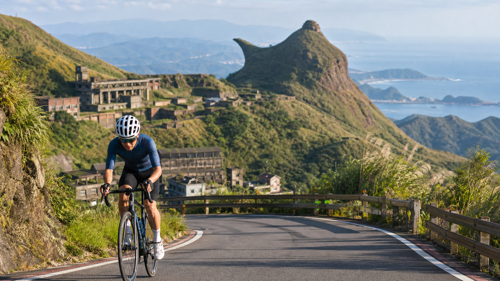
Route Overview: A Mid-Length Climb Shaped by Mining Terrain
The Jinguashi Teapot Mountain climb spans 3.15 kilometers with a total elevation gain of 223.6 meters and an average gradient of 7.1%. Placed within the classification framework of Taiwan’s cycling climb routes, these figures place it squarely in the category of a “moderate intensity, moderate length” climb—not as short and explosive as the Juming Museum climb, nor requiring the multi-hour endurance output of routes like the Northern Cross-Island Highway or Hehuan Mountain. For riders with some climbing experience, a 7.1% average gradient falls into an intensity range that is “noticeable but manageable,” suitable for maintaining a relatively steady rhythm throughout, while still offering enough challenge to make riders who arrive unprepared feel significant physical exertion.
The official name for this segment on Strava is “Teapot Mountain TT-1 (starting from the archway),” which, as the name suggests, typically uses a certain archway landmark as the reference starting point, with the finish direction pushing toward the Teapot Mountain area. Teapot Mountain itself stands at 602 meters in elevation and belongs to the Caoshan mountain system within the Ruifang Scenic Specific Area. It is named for its resemblance to a teapot without a handle, and is also colloquially known locally as the “Handleless Teapot Mountain.” Interestingly, when viewed from the north, the mountain’s shape resembles a crouching lion, which is why it was formerly also called “Lion Rock.” This phenomenon of different names arising from different viewing angles, to some extent, echoes the complex and varied topographical characteristics of this mining region.
The area where this climb is located belongs to the well-known Jinguashi mining settlement in Ruifang District. Geologically, it is part of a silicified breccia ore pipe, itself a component of the Third Changren gold-copper ore body—in other words, the slopes beneath your wheels were once an extremely important resource deposit in Taiwan’s mining history. This geological backdrop lends the entire climb an additional layer of historical depth, making it more than just a simple physical training ground.
Segment-by-Segment Strategy from Start to Finish: Four-Phase Pace Management
Breaking the 3.15 km, 7.1% average gradient route into four phases to plan your riding rhythm can help you allocate energy more efficiently and avoid running out of steam in the later stages.
Segment 1 (approximately 0–800 m after the start): Establishing Your Pace Baseline
This is the warm-up and rhythm-setting phase of the entire climb. With a 7.1% average gradient falling in the moderate intensity range, it is recommended to pedal at the cadence you typically use on longer climbs during the opening phase, keeping your heart rate around 75% to 82% of your maximum to avoid going out too hard from the start. Cadence in this phase should be maintained at a medium-to-high spin of 80 to 90 rpm, allowing your muscles to gradually enter a loaded state rather than grinding a heavy gear from the outset and causing premature lactate accumulation.
Segment 2 (approximately 800 m–1.8 km): A Section Where the Gradient May Shift
The 7.1% average is just that—an average—so the actual gradient along the route will inevitably fluctuate. This section requires sustained focus, adjusting gears and cadence in response to gradient changes at any moment. When encountering noticeably steeper sections, shifting down appropriately and spinning a higher cadence to maintain stable power output is more efficient than stubbornly holding the same gear and letting your cadence drop too low. Your heart rate can gradually rise to around 83% to 88% of maximum during this phase—this is the main sustained-output zone of the entire route.
Segment 3 (approximately 1.8–2.6 km): The Mid-to-Late Section Where Fatigue Hits Hardest
This is the stage where both mental and physical challenges are most pronounced. The fatigue accumulated from the earlier sections begins to surface, and many riders experience the “how much longer” mental struggle here. It is recommended to deliberately divert your attention during this phase—for example, by focusing on your breathing rhythm or road surface details—rather than dwelling on the fatigue itself and amplifying the sensation of discomfort. If your energy is clearly flagging, consider briefly easing off the pace and extending the coordination between cadence and breathing, rather than stopping abruptly—maintaining forward motion is generally more efficient than coming to a complete stop and having to restart.
Segment 4 (approximately 2.6–3.15 km, the Finish Section): Wrapping Up with a Landscape Transition
Entering the final stretch, as elevation continues to rise, the views and scenery gradually shift from ordinary mountain roads to the exposed geological landscapes unique to the mining area, and the rock profile of Teapot Mountain may begin to come into view. This is the most visually rewarding phase of the entire route. It is recommended to channel the fatigue of this final section into anticipation for the imminent completion of the challenge, adjust your breathing rhythm appropriately, and close out steadily.
Gearing and Equipment: A Balanced Setup for a Moderate-Intensity Climb
Compared to the extreme steepness of the Juming Museum climb, which demands ultra-light gearing, the 7.1% average gradient of Teapot Mountain falls within what a standard road bike climbing setup can handle, though adjustments based on individual ability are still recommended.
| Bike Type / Rider Level | Recommended Gearing | Notes |
|---|---|---|
| Advanced riders (extensive climbing experience) | 50/34 compact crank with 11-28 cassette | A standard race-level setup is sufficient for the sustained 7.1% average climb; even on steeper local sections, a reasonable cadence can still be maintained |
| Intermediate / general recreational riders | 50/34 or 46/30 compact crank with 11-30 or 11-32 cassette | The wider cassette range provides more buffer in the later stages when energy dips, reducing the risk of blowing up |
| Beginner riders | Recommend a gravel-oriented or lighter gearing setup | If you have limited experience with mid-length climbs, choose a wider-range gearing configuration to avoid being forced to stop and walk mid-climb |
Beyond gearing, because this route is located in mining terrain, some sections may have more loose gravel or weathered rock debris due to geological characteristics. It is recommended to choose tires with better grip and puncture resistance, and to retain a bit of tire pressure buffer to cope with potentially uneven road surfaces.
Nutrition and Hydration Management: Sustained-Output Characteristics of a Mid-Length Climb
Compared to the short-duration, high-intensity fueling logic of the Juming Museum climb, Teapot Mountain’s relatively longer riding time (approximately 15 to 30 minutes depending on individual ability) means the fueling strategy is closer to the sustained management approach of a typical mid-length climb.
It is recommended to ensure your bottle is at least 80% full before setting off, and if the weather is hot, consider carrying a sports drink to replenish electrolytes. During the ride, if you feel noticeable fatigue accumulating, you can take a small amount of energy gel or simple carbohydrates on the gentler sections to avoid a blood sugar crash affecting your performance in the later stages.
The Ruifang and Jinguashi area, catering to tourism demand, has a reasonable number of shops and dining options in the vicinity. When planning your trip, you can schedule your pre-ride preparation time around the Jinguashi settlement, and after completing the ride, take a brief rest nearby to replenish fluids and calories.
Weather and Seasons: The Northeast Coast’s Characteristic Rain-Prone Climate
Jinguashi, located in Ruifang District, geographically belongs to Taiwan’s northeast coast—one of the regions with the highest rainfall probability in all of Taiwan. This is a critical variable that must be factored into any plan to ride this route.
Autumn and Winter (approximately October to March of the following year): During the prevailing northeast monsoon season, the northeast coast is frequently shrouded in damp, cold, and rainy weather patterns. Even on brief overcast days, rain can fall at any time in the mountains. Wet surfaces on steep sections significantly increase riding risk. It is recommended to check real-time weather forecasts and rainfall information before setting out during this season. If there is significant rainfall or dense fog affecting visibility, it is advisable to postpone the trip.
Summer (approximately June to September): While rainfall probability remains relatively high on the northeast coast in summer, there are comparatively more clear and stable weather windows than in autumn and winter. This is one of the best seasons for visibility—when visibility is good, the coastal views and mining-area landscapes around the summit can be seen in full. However, afternoon thunderstorms in summer still require attention; it is recommended to schedule departures in the morning to avoid the period of strong afternoon convection.
Spring: Overall weather is relatively unstable, with alternating warm and cold conditions. It is recommended to dress in layers to cope with temperature swings and to keep a close eye on real-time weather changes before riding.
Regardless of season, because this route is located in mountainous terrain with geologically distinctive sections, extra attention should be paid to wet road surfaces and visibility conditions. Safety should always take priority over chasing speed records.
Common Mistakes and Risk Reminders
Mistake 1: Underestimating Mid-Route Fatigue Accumulation and Pacing the Early Section Too Fast
A 7.1% average gradient does not deliver the immediate, intense physical impact of an extremely steep short climb, which can easily lull riders into complacency in the early section and start with overly high power output. The result is a sharp decline in energy by the mid-to-late stages, ultimately slowing overall completion time. It is recommended to maintain a steady-pace mindset throughout rather than sprinting early and hanging on for dear life later.
Mistake 2: Ignoring Road Surface Geological Characteristics and Choosing Inappropriate Tire Pressure/Width
Some sections of the mining terrain may have weathered rock debris or loose gravel. If you use overly narrow race tires inflated to very high pressure, the risk of slipping or puncturing increases on uneven surfaces. It is recommended to adjust tire pressure appropriately based on current road conditions and to choose tire models with a balanced combination of grip and puncture resistance.
Mistake 3: Failing to Account for the Northeast Coast’s Changeable Weather and Lacking Preparedness for Sudden Rain
As detailed in the weather section above, this region has a high probability of rainfall with rapid changes. It is recommended to carry a lightweight rain jacket or windbreaker during the ride and to be alert to the possibility of mountain fog affecting visibility and road-condition assessment.
Mistake 4: Neglecting to Pay Attention to Mixed Pedestrian and Vehicle Traffic Near the Finish
Because of the hiking trails and tourist crowds around Teapot Mountain, roads near the finish may have more pedestrians and tourist vehicles. It is recommended to moderate your speed as you approach the final section and stay alert to the movements of surrounding pedestrians and vehicles to ensure safety.
Reference Finish Times for Riders of Different Levels
The following times are for reference only; actual performance will vary due to individual fitness, weather conditions, equipment, and other factors:
| Rider Level | Reference Finish Time | Notes |
|---|---|---|
| Advanced / race level | Approximately 9–13 minutes | Possesses solid climbing endurance, able to sustain stable high power output throughout, with only minor rhythm adjustments at gradient changes |
| Intermediate / consistent riding habits | Approximately 15–22 minutes | Has basic mid-length climb experience, paces steadily but may slow slightly in the mid-to-late stages |
| Beginner / first-time challenger | Approximately 22–35 minutes | Recommended to aim for completion rather than speed; may take short breaks as needed along the way |
Because this route has a moderate length and a manageable gradient range, it is well suited as a training route for general riders to practice pace management and climbing rhythm control. Unlike extremely steep short climbs that can exhaust energy in an instant, it better cultivates the habit of stable, sustained output.
Training Plan Recommendations: How to Systematically Improve Your Performance on This Climb
A mid-length climb with a 7.1% average gradient and 3.15 km length is a route type that is relatively amenable to performance improvement through systematic training. Unlike extremely steep short climbs that rely heavily on explosive power, it aligns more closely with traditional aerobic climbing training logic. With the right approach, the improvement curve is usually more pronounced.
Tempo Ride Training: It is recommended to schedule one tempo-intensity session per week. Find a section of road 10 to 20 minutes long with a moderate gradient and ride at an intensity near your lactate threshold but still sustainable. This type of training most closely mirrors the overall intensity distribution of the Teapot Mountain climb and helps improve your body’s ability to sustain output at moderate intensity.
Climbing-Specific Cadence Training: Many riders unconsciously grind at excessively low cadences when climbing, which over time places strain on the knee joints and leads to premature exhaustion. It is recommended to deliberately practice climbing at a higher cadence (90 rpm or above) with a lighter gear during regular training, teaching your body to adapt to a more efficient pedaling pattern. This will directly help with gear adjustments when the gradient shifts in the middle section of the Teapot Mountain climb.
Pace Management Practice Sessions: Because this route is excellent for practicing pace management, it is recommended to schedule several sessions with the goal of “completing at an even pace” rather than chasing the fastest finish time. Through repeated practice, you will gradually learn the optimal energy allocation across the early, middle, and late sections of a mid-length climb—a capability that will serve as an important foundation for tackling longer climbs in the future.
Recovery and Stretching: Climbing places significant demands on the quadriceps, glutes, and calf muscles. It is recommended to schedule appropriate stretching and foam roller work after training sessions to avoid muscle tightness affecting your next session’s performance and to reduce the risk of injury.
Extended Challenges: Linking Up with Other Notable Northeast Coast Routes
For riders already familiar with the Teapot Mountain climb who want to raise the challenge level further, the northeast coast area offers several worthwhile route options that can be combined into longer, more demanding, and scenically richer multi-day itineraries.
The mountainous terrain in this area is highly varied. From Ruifang and Shuinandong to Fulong and Gongliao, the interweaving of coastal and mountainous topography has given rise to many distinctive climbing sections. Incorporating the Teapot Mountain climb into a longer northeast coast loop not only extends overall riding distance and time but also allows you to experience vastly different terrain and cultural landscapes across different sections—from the weathered atmosphere of mining settlements, to the leisurely pace of fishing villages, to the expansive views of coastal highways. This multi-layered landscape transition is precisely what makes northeast coast routes most appealing to long-distance riders.
In addition, the nearby Jinshui Road is itself a route rich in cultural and scenic character, offering views of notable sights such as the Golden Waterfall and the Shuinandong Refinery ruins along the way. If time and energy permit, consider combining both routes into a single day’s itinerary to experience the multifaceted character of the Jinguashi mining settlement from different perspectives.
If your long-term goal is to take on other well-known mid-to-long climbs in Taiwan, the Teapot Mountain climb’s 7.1% average gradient and sustained, stable-output intensity profile make it an excellent calibration benchmark—riders who can maintain a steady pace and complete the challenge without excessive exhaustion typically also possess the foundational fitness to handle longer climbs.
Equipment Maintenance and Long-Term Usage Recommendations
Because some sections of the Teapot Mountain climb’s mining terrain may contain higher amounts of fine weathered rock debris and dust due to geological characteristics, repeatedly riding this type of route over the long term will cause noticeably greater wear on your drivetrain and braking system than on typical asphalt mountain roads—a maintenance detail many riders tend to overlook.
Drivetrain Cleaning: After each ride on this type of mining terrain, it is recommended to check whether the chain, cassette, and chainrings have accumulated excessive dust or grit, clean them as needed, and reapply lubricant to prevent abrasive residue from accelerating drivetrain wear. For riders who frequently ride this type of terrain, chain replacement intervals may be slightly shorter than for general asphalt riding; it is recommended to regularly check chain stretch.
Brake System Inspection: Whether you use rim brakes or hydraulic disc brakes, the frequent braking during climbs and descents, combined with road dust that may adhere to brake pads or rotors, makes it advisable to regularly check brake pad wear to ensure braking power remains stable and reliable. This is especially important on mountain routes, as brake system reliability is directly tied to riding safety.
Tire Condition Tracking: As mentioned in the equipment section, some sections of the mining terrain may have more loose gravel. It is recommended to inspect tires after rides for embedded debris or visible cuts, catching potential puncture risks early and avoiding being caught off guard on the next ride.
Frame and Component Bolt Inspection: Prolonged out-of-saddle climbing and routes with frequent gradient changes also put stress on the torque of various bolts on the frame. It is recommended to periodically use a torque wrench to check the tightening torque of critical areas (handlebars, stem, seatpost, etc.) to ensure riding safety.
These seemingly trivial maintenance details, accumulated over time, provide tangible benefits in extending the lifespan of bike components and ensuring the safety and performance of every ride. For riders who frequently travel on mining and mountain terrain routes in particular, developing a habit of regular inspection and maintenance is well worth the effort.
Individualized Recommendations for Riders with Different Goals
Finally, here are some more specific, individualized recommendations for riders with different purposes, to help you plan this challenge more effectively.
If your goal is to maximize training effectiveness: Choose weekday time slots with less traffic, repeatedly practice pace control at a fixed intensity, and use a heart rate monitor or power meter to precisely record data changes from each ride. Accumulated over time, you will clearly see your progress in pace management and climbing endurance.
If your goal is recreational experience and scenery appreciation: Choose a clear-weather weekend morning, ride at a more relaxed pace, stop several times along the way to appreciate the mining-area landscapes and distant sea views, and focus on the experience and sensation rather than chasing speed records.
If you are a group ride organizer: Because the Teapot Mountain climb has a moderate length and a manageable medium gradient, it is well suited as a featured challenge segment in group ride activities. However, it is still recommended to allow ample regrouping and waiting time based on the ability gaps within the group, to avoid weaker members overexerting themselves to keep up.
If you are planning a multi-day northeast coast riding itinerary: It is recommended to schedule this route in the middle of the itinerary rather than at the end, to avoid tackling this climb when your energy has already been substantially depleted, which could compromise the quality of the ride and safety.
If you are a beginner new to mid-length climb training: There is no need to set overly ambitious target times from the start. It is recommended to make “completing the full distance without stopping” your first-stage goal. After accumulating several complete ride experiences, gradually challenge yourself to improve pacing and time. A progressive training rhythm will, in the long run, better sustain your enthusiasm for riding and maintain a healthy balance with your body’s load than chasing speed from day one.
Frequently Asked Questions
Is this route suitable for bikes other than road bikes? Gravel bikes, road bikes with gravel-oriented setups, and even some mountain bikes can all handle the gradient and road conditions of this route. Since some sections may have loose gravel geology, wider-tire models may actually have an advantage in grip and comfort.
Do I need to apply in advance or are there restricted times? General road riding typically does not require special application, but it is recommended to check before riding whether there are any temporary traffic controls or event road closures in the area. Especially on weekends when tourist crowds are heavier, some sections may have traffic management measures in place.
Is it suitable for night riding? Because this route is located in mountainous terrain with limited nighttime lighting and noticeable gradient changes on some sections, night riding is not recommended without adequate lighting equipment. If you truly must ride during low-light hours, be sure to equip front and rear lights and reflective gear, and reduce your speed to ensure safety.
Summary: A Mid-Length Climb Combining Training Value with Cultural and Scenic Richness
The Jinguashi Teapot Mountain climb, with its combination of 3.15 kilometers, 223.6 meters of elevation gain, and a 7.1% average gradient, offers a relatively balanced climbing training scenario—intense enough to present a clear physical challenge, yet with a length and gradient distribution that give riders ample room to practice pace management and rhythm control. Combined with the distinctive mining-area landscapes that gradually reveal themselves along the way and the rock formations of Teapot Mountain itself, this route offers a visual experience different from typical mountain climbs, in addition to its training value.
Whether you treat it as a standalone training goal or incorporate it as one segment of a longer northeast coast or Jinguashi–Jiufen area riding itinerary, as long as you handle the three fundamentals—gearing configuration, nutrition planning, and weather assessment—this route will be a riding experience worth recording.
Related Reading
- Jinguashi Jinshui Road Practical Guide: Complete Segment-by-Segment Analysis of a 4.84 km Climb with 6.3% Average Gradient
- Riding Toward Teapot Mountain: A Mountain Road Journey Through a Century of Mining Memory
- Zhongliao Erjian Mountain Guide: Complete Analysis of a 7.3% Hardcore Hidden Climb in Nantou’s Tea Country Hills
- Mao Kong Zhinan Temple Practical Guide: Complete Analysis of Taipei’s Classic Intermediate Climb—6.93 km, 388 m Elevation Gain, 5.6% Average Gradient
無耳茶壺山 半屏山 空拍震撼絕景 驚險O型縱走
8 年前
半日 小台灣 極限單車路線挑戰實錄
7 年前
[空拍][4K] 茶壺山 驚險攀爬之旅 預告
8 年前
那瑪夏x茶山 阿里山系深山單車行 Day2 累積爬升6000M | 🥶超陡連續下坡 整路看隊友刷 | 爬升一座西進武嶺 | JJSC | 公路車 | CT Yeh
3 年前
台北闊瀨陡坡 騎旅 / 日本單車雜誌編輯車友臨時加入!/ 髮香才是最強的 / feat. 北迴歸線小隊 / 公路車 CT Yeh
6 個月前
嘉義單車路線推薦:碧湖山茶園超陡坡挑戰!里佳部落-奮起湖-瑞峰 (附路線)
7 個月前
大武山後門26%歡樂陡坡!JJSC南台灣單車行Day2 / 被颱風追著跑 / 公路車 / CT Yeh
2 年前
一定要騎一次!阿里山最深處:里佳部落!單車旅行 | 2800m爬升 | 深度部落體驗:嗨翻晚會、螢火蟲、銀河 | feat. JJSC & 廢物伙伴 | 公路車 CT Yeh
10 個月前