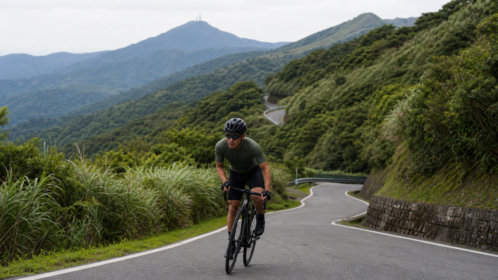
Maocao Mountain Road Practical Guide: A Hidden 9.9 km Training Route with Rolling Terrain
Summary: Maocao Mountain Road spans 9.9 km, with Strava recording 607 meters of elevation gain and an average gradient of 4.5%. Compared to the theoretical elevation gain of 444 meters calculated from the average gradient, the actual gain is significantly higher, indicating that this route also features considerable rolling sections. This article breaks down segment gradients, gear ratios, and training applications to help riders master this relatively obscure yet solid mountain road route.
Maocao Mountain Road is located in the Jinshan District of New Taipei City, geographically close to the Yangjin Highway and Maocao Section, and belongs to the mountain road network surrounding the Datun Volcano Group. The route spans 9.9 km in total length, with Strava recording 607.4 meters of total elevation gain and an average gradient of 4.5%. The theoretical elevation gain calculated from distance and average gradient is approximately 444 meters, but the actual recorded gain exceeds the theoretical value by about 37%, indicating that this route also includes a considerable degree of rolling sections, rather than being a purely continuous climb.
Compared to major thoroughfares like the Yangjin Highway, which carry heavier traffic and greater recognition, Maocao Mountain Road is a relatively obscure mountain road with sparse traffic—a hidden training route passed down by word of mouth among riders familiar with the local road network. With few people and vehicles, tranquil road conditions, and solid, varied gradients, this route is particularly suited for riders who prefer a quiet training environment without traffic interference. Below, we break down the route’s gradient characteristics by segment and provide practical pacing and equipment recommendations.
Route Overview and Real Data Analysis
Let’s look at the hard numbers first. Maocao Mountain Road spans 9.9 km in total, with 607.4 meters of total elevation gain and an average gradient of 4.5%, placing it in the medium difficulty category (Category 3). As mentioned earlier, the actual elevation gain is significantly higher than the theoretical value, indicating rolling sections along the way that require riders to adopt a dynamic pacing strategy rather than simply applying a fixed average-gradient pacing mindset.
| Item | Data |
|---|---|
| Total Distance | 9.9 km |
| Total Elevation Gain | 607.4 meters (Strava record) |
| Average Gradient | 4.5% |
| Category | Category 3 (medium difficulty) |
| Terrain Characteristics | Localized rolling sections; actual gain exceeds theoretical value of distance × average gradient |
| Traffic Conditions | Relatively sparse; suitable for quiet training |
Because this route is located in the Jinshan mountain area, its terrain characteristics share similarities with the Yangjin Highway and Maocao Section—both are hilly terrain surrounding the Datun Volcano Group, with fragmented topography and highly varied gradients. However, Maocao Mountain Road has a relatively narrower road width and even less traffic, making the riding experience feel closer to a “private training road.” This is also a key reason why it has gradually built a reputation among riders familiar with the local road network.
Segment Guide: Warm-Up Start and Initial Climb (0–3 km)
During the first 3 km after departure, the route first passes through a relatively gentle warm-up climb with gradients around 2–4%, allowing the body to gradually enter a working state. For this section, it is recommended to maintain a medium-to-light gear ratio (such as 50x17 or 50x19), keep cadence around 85–90 rpm, and control heart rate between Zone 2 and Zone 3, reserving ample energy for the rolling sections that may follow.
Since Maocao Mountain Road has sparse traffic, this section is well-suited for practicing steady cadence control and breathing rhythm without worrying about being urged or disturbed by vehicles from behind. It is recommended to treat this warm-up stretch as an opportunity to adjust your riding condition for the day—by observing your heart rate and perceived exertion, you can judge whether your physical state that day is suitable for tackling the higher-intensity core climb sections.
Segment Guide: Core Rolling Zone (3–7 km)
The 3-to-7 km stretch is the core section of Maocao Mountain Road where climbing is most concentrated and undulations are most pronounced—precisely why the actual elevation gain exceeds the theoretical value. Here, continuous climbs interspersed with brief descents may occur, with instantaneous gradients often reaching 6–8% during climbing segments. It is recommended to adopt the aforementioned “intermittent pacing” strategy, treating each climb as an independent short ascent, moderately increasing output toward threshold power, and actively relaxing and recovering during descents or gentle slopes.
For gear ratio configuration, it is recommended to prepare at least a 34x25; if you have limited climbing experience or carry a heavier body weight, you can go straight to 34x28 or 34x30 to ensure sufficient margin to maintain a stable cadence when sudden steep sections appear. Because road conditions are relatively quiet, this section is also suitable for practicing advanced riding techniques such as out-of-saddle cornering and accelerating out of turns, without safety concerns from unexpected traffic.
Segment Guide: Final Stretch and Reaching the Summit (7–9.9 km)
After passing the 7 km mark, the gradient gradually eases, but since the core rolling zone has already consumed significant energy, it is advisable to maintain moderate alertness and avoid hastily increasing output just because the gradient appears gentler, which could lead to cramping or a cliff-like drop in energy in the later stages. For this final section, it is recommended to maintain a steady cadence and complete the remaining stretch with a more relaxed mindset, while also taking in the changing mountain scenery and allowing your tense body and mind to unwind appropriately.
After reaching the summit, it is recommended to rest briefly, replenish fluids, and let your heart rate settle before considering a return along the same route or connecting to other nearby routes to continue your ride. Because Maocao Mountain Road is geographically close to the Yangjin Highway and Maocao Section, many riders link these routes together to plan a grand Jinshan mountain tour covering a variety of gradient combinations.
Gear and Equipment Recommendations
Because Maocao Mountain Road features rolling gradients with instantaneous gradients reaching 6–8%, it is recommended that road bikes be equipped with a compact crankset (50/34T) paired with an 11-28T or 11-30T cassette, balancing climbing margin and flat-road efficiency. Riders who are heavier or have less climbing experience may consider a wider-range cassette to ensure sufficient gear flexibility in the core rolling zone.
Since road conditions on Maocao Mountain Road are relatively primitive and pavement smoothness may not match major thoroughfares, it is recommended to use 25–28C tires with better grip and puncture resistance, and to adjust tire pressure downward according to body weight for increased comfort and cornering stability. Given the sparse traffic but narrower road width, it is recommended to equip front and rear lights and reflective accessories to enhance your visibility, ensuring that other road users can spot you early even on corners with limited sightlines.
Nutrition, Hydration, and Weather/Season Considerations
Because Maocao Mountain Road is located in a relatively remote mountain area, supply points are scarce or may be entirely absent along the route. It is recommended to complete your provisioning in Jinshan urban area or nearby settlements before departure, and carry sufficient water to cope with the energy expenditure of the full 9.9 km with 607 meters of actual climbing. The climate around Jinshan is similar to that of the Yangjin Highway area—hot and humid in summer with strong afternoon convection—so an early morning departure is recommended to avoid peak heat hours. In winter, under the influence of the northeast monsoon, the mountain area is prone to fog and rain, increasing the risk of slippery roads; riders should carefully assess weather conditions before riding.
Common Mistakes and DNF Risks
The most common mistake on Maocao Mountain Road, similar to Shuangxi Buyan Pavilion, is underestimating the impact of terrain undulations on energy distribution, using average gradient figures to estimate difficulty and thus misjudging pacing. It is strongly recommended to assess your physical preparedness based on the actual 607 meters of elevation gain rather than the surface-level 4.5% average gradient. Additionally, because the route is relatively obscure with few people and vehicles, if a mechanical failure or physical discomfort occurs, the time required to wait for rescue or walk to an area with signal may be longer. It is strongly recommended to ride with companions or inform family and friends of your route, and to carry sufficient emergency contact information and basic repair tools.
Target Time References for Riders of Different Levels
| Rider Level | Estimated Completion Time | Notes |
|---|---|---|
| Advanced / Race level | 28–35 minutes | Familiar with pacing techniques on rolling terrain |
| Intermediate / Regular training | 36–48 minutes | Intermittent pacing strategy recommended |
| General recreational rider | 48–65 minutes | Conservative pacing; watch energy distribution |
| Beginner / First attempt | 65+ minutes | Ride with companions; watch nutrition |
Training Applications and Route Network Connections
Because Maocao Mountain Road has sparse traffic and gradients that offer a solid challenge, it is an ideal venue for structured interval training. You can arrange 2–3 repeated ascents of the core rolling zone to simulate the alternating steep-and-gentle terrain changes of real race scenarios, improving pacing adaptability and normalized power control. Given its geographic proximity to the Yangjin Highway and Maocao Section, advanced riders familiar with the local road network can also incorporate Maocao Mountain Road into a larger Jinshan mountain loop route, linking together a long training ride covering multiple gradient characteristics and fully utilizing the rich terrain resources of this mountain road network.
In summary, although Maocao Mountain Road is not as well-known as the Yangjin Highway, its tranquil road conditions and solid gradient combinations have made it a hidden treasure route in the minds of riders familiar with the local road network. Whether you seek a quiet training environment or want to challenge your terrain adaptability, this route deserves a place on your northern Taiwan riding shortlist.
Practical Power and Heart Rate Configuration Details
For riders equipped with power meters, the power fluctuation characteristics of Maocao Mountain Road’s core rolling zone share similarities with Shuangxi Buyan Pavilion. It is recommended to similarly focus on normalized power and variability index rather than relying solely on average power to assess ride intensity. During the core rolling section, it is recommended to keep instantaneous output between 90–110% of threshold power, and actively drop to 70–80% during brief descents or gentle slopes, allowing the body to maintain a relatively stable overall metabolic load amid the fluctuating rhythm.
For riders without power meters, heart rate can serve as an alternative reference indicator. During the core rolling section, it is recommended to keep heart rate around 83–90% of maximum heart rate, paired with a steady breathing rhythm, to avoid unconsciously overexerting due to the alternating steep-and-gentle gradients, which could cause heart rate to swing dramatically and slow recovery. It is recommended to periodically use this route as a test of cardiorespiratory adaptability, recording completion times and heart rate curve changes as objective reference data for training effectiveness.
Road Conditions and Safe Riding Guidelines
Because Maocao Mountain Road has sparse traffic, narrower road widths on some sections, and pavement smoothness that may not match major thoroughfares, riders must remain highly alert. It is recommended to brake and control speed well before corners, especially on bends with limited sightlines where you cannot predict oncoming traffic or obstacles—conservative riding is always the first principle of safety. Mountain roads occasionally have falling rocks, moss, or gravel accumulation, and the risk of slippery roads increases after rain. It is recommended that when riding in rain or after rain, cornering and braking actions be more conservative and cautious.
Because the route is relatively remote, it is recommended to avoid challenging Maocao Mountain Road alone during dusk or periods of poor visibility. If you must ride in low-light conditions, be sure to equip a proper front light and rear light, and wear cycling apparel with reflective elements to increase your visibility on sections with limited sightlines and reduce the risk of traffic accidents.
Terrain Comparison with Nearby Routes
Comparing Maocao Mountain Road with the Xiaoyoukeng section of the Yangjin Highway and the Maocao Section, one finds that although all three belong to the road network surrounding the Datun Volcano Group in the Jinshan mountain area, their terrain characteristics differ. The Xiaoyoukeng section of the Yangjin Highway has a relatively “honest” gradient distribution, with elevation gain and average gradient figures closely matching; the Maocao Section has concentrated and compact gradients, representing short-duration high-intensity climbing; while Maocao Mountain Road features pronounced rolling characteristics, with elevation gain significantly exceeding the theoretical value, closer to the terrain type of Shuangxi Buyan Pavilion that requires dynamic pacing.
This terrain diversity is actually quite advantageous for training planning—riders can select routes with different characteristics based on their weekly training goals. For practicing steady threshold power output, the Xiaoyoukeng section of the Yangjin Highway is a good choice; for high-intensity short intervals, the Maocao Section is ideal; for honing terrain adaptability and normalized power control, Maocao Mountain Road provides an excellent training context. The three routes are geographically close and can even be planned as sequential segments within a single long ride, greatly enhancing the training efficiency and terrain diversity of a single outing.
Reminders for First-Time Challengers of Maocao Mountain Road
Riders attempting Maocao Mountain Road for the first time should first check the day’s weather and road condition information to confirm whether there are construction or closure situations on the route—because obscure mountain roads lack real-time condition reporting, it is recommended to confirm the latest route status through local rider communities or previous ride records. At the same time, due to scarce supply resources, it is recommended to carry sufficient water and basic tools, and to ride with companions whenever possible to reduce the risk of facing unexpected situations alone.
After completing the challenge, feel free to share your ride data and insights with the cycling community, helping more riders discover this relatively obscure yet highly valuable training route. This way, the hidden treasure of Maocao Mountain Road can be discovered and appreciated by more enthusiasts, while also accumulating more complete road condition and safety information through community efforts, allowing future visitors to be better prepared before their rides.
Advanced Riders’ Combination Play: The Jinshan Mountain Trilogy
For advanced riders already familiar with the Xiaoyoukeng section of the Yangjin Highway, the Maocao Section, and Maocao Mountain Road respectively, a challenge that has gradually gained traction in the community is linking these three routes into a “Jinshan Mountain Trilogy,” completing them sequentially in a single day’s ride. A typical arrangement begins with the Xiaoyoukeng section of the Yangjin Highway as a long-distance endurance warm-up to test overall pacing control; then transitions to the Maocao Section, using its concentrated gradients for a high-intensity threshold power test; and finally tackles Maocao Mountain Road, using its varied rolling terrain to test whether you can maintain stable terrain reading and pacing adaptability even after considerable energy expenditure.
This combined challenge covers a total distance of over 30 km, with total elevation gain potentially exceeding 1,500 meters—a considerable challenge for riders without adequate training foundations. It is recommended to progress gradually, first familiarizing yourself with each individual route before attempting the full trilogy. After completing the entire challenge, many riders share that the sense of accomplishment from experiencing three distinctly different gradient characteristics far exceeds completing any single route, and leaves a more three-dimensional, richer training memory of the Jinshan mountain area.
Equipment Durability and Long-Term Maintenance Recommendations
Because road conditions on Maocao Mountain Road are relatively primitive, the frequent gradient changes and possible gravel surfaces cause more noticeable wear on the drivetrain and braking systems than on typical smooth roads. It is recommended to regularly check the wear condition of the chain, cassette, and chainrings. Especially if Maocao Mountain Road is regularly included in your fixed training menu, the drivetrain maintenance interval should be appropriately shortened to ensure shifting response remains in optimal condition, avoiding shifting delays caused by component wear that could affect pacing rhythm at critical gradient transitions.
The braking system also requires attention, especially on the descent sections when returning along the same route. Continuous braking places significant heat load on brake pads and rims or rotors. It is recommended to regularly check brake system wear and heat dissipation after rides, replacing consumables as necessary to ensure braking performance remains at a safe and reliable level during long-term riding on such rolling routes.
Choosing Riding Times: Early Morning and Evening
Because Maocao Mountain Road has sparse traffic and relatively high tree canopy coverage, the light changes during early morning and evening hours deserve special attention. Departing in the early morning avoids daytime heat, and with mountain tree cover, the perceived temperature is more comfortable than on open sections, making it the preferred departure time for most riders. However, fog is common in the mountains during early morning, which may affect visibility. It is recommended to slow down and equip appropriate lighting and reflective gear to ensure you remain clearly visible on foggy sections.
Challenging Maocao Mountain Road in the evening requires more careful assessment of how quickly daylight fades. After sunset in the mountains, light diminishes faster than in urban areas, and tree cover further compresses visible distance. It is strongly recommended to keep track of time, ensuring you complete the ride before full darkness, or prepare ample lighting equipment in advance to cope with sudden darkness. Regardless of which time you choose to depart, carrying lights and reflective accessories is an indispensable basic requirement for riding such sparsely trafficked mountain roads.
Cultivating Mental Toughness and Independent Problem-Solving Skills
Precisely because Maocao Mountain Road has few people and vehicles and limited supply resources, this route is also an excellent training ground for developing riders’ independent problem-solving abilities and mental toughness. When facing sudden mechanical failures, energy depletion, or weather changes, you cannot easily obtain immediate assistance from other riders or passersby as you would on popular routes. This relatively isolated riding context effectively hones riders’ ability to stay calm, assess situations, and solve problems independently.
It is recommended that riders ensure they possess basic mechanical troubleshooting skills before challenging Maocao Mountain Road, such as changing tires and simple derailleur adjustments, and carry complete emergency contact information and a tracking device. In the event of an unexpected situation, you can respond quickly and calmly. This self-reliance cultivated in relatively isolated environments will, in the long run, give riders greater confidence and preparedness when facing other more challenging long-distance or remote routes.
Summary: A Quiet Training Ground Worth Revisiting
Maocao Mountain Road may not appear on the rankings of popular check-in routes, but it is precisely this relatively low-key character that makes it a treasured option in the minds of many seasoned riders, combining training value with a serene atmosphere. The 9.9 km distance, 607 meters of actual elevation gain, and pronounced rolling terrain features give this route dual value as both a physical training ground and a test of terrain adaptability—a route worth keeping on the long-term training shortlist for northern Taiwan riders.
Whether you are looking for a training venue far from traffic noise where you can focus on dialogue with yourself, or you want to challenge the terrain variations hidden behind gradient data, Maocao Mountain Road will respond to every rider’s effort and perseverance with its consistently low-key yet solid character. It helps you continuously accumulate climbing strength and terrain-reading experience, and through repeated visits, you will find your own training rhythm and riding pleasure on this tranquil mountain road—transforming every seemingly ordinary training day into valuable nourishment for steadily building strength, making Maocao Mountain Road an indispensable partner in your cycling journey toward continuous improvement.
Additional Reminder: The Importance of Road Condition Updates and Community Reporting
Because Maocao Mountain Road is a relatively secondary mountain road, maintenance frequency and resources may not be as ample as on major thoroughfares. The road surface may occasionally have localized potholes, leaf accumulation, or vegetation encroaching on the shoulder. It is recommended that riders develop the habit of checking the latest ride records and road condition reports through cycling communities before departure. If abnormal road conditions are discovered, proactive reporting is also encouraged so that subsequent visitors can be informed in advance and make proper safety preparations, jointly maintaining the riding quality and safety of this hidden training route.
Related Reading
- A Solo Ride on Maocao Mountain Road: The Forgotten Quiet Mountain Path in the Depths of Jinshan
- Yangjin Highway Maocao Section Practical Guide: A 6.3 km High-Intensity Short Climb Interval Training Haven
- Dongfu Highway Practical Guide: Pacing Traps and Gear Tactics on a 17.9 km Rolling Road
- Shuangxi Buyan Pavilion Practical Guide: Gradient Traps and Pacing Solutions on a 9.7 km Rolling Route
台北闊瀨陡坡 騎旅 / 日本單車雜誌編輯車友臨時加入!/ 髮香才是最強的 / feat. 北迴歸線小隊 / 公路車 CT Yeh
6 個月前
大禹嶺 到 武嶺牌樓 全程前後實況錄影 | 北進武嶺 | 東進武嶺 | KOM | 訓練台 | 坡度分析 | Taiwan KOM Last 10 km HARD | 公路車
6 年前
單車 梅山36灣 坡度介紹 路段介紹 空拍 (相關遊記影片,請參考說明或我的頻道喔,歡迎訂閱)
6 年前
一個測試有沒有認真練車的方法😂 #公路車
10 個月前
經典 陽金P字道 | 路線解析 | 魔王親臨指導 | 武嶺備戰訓練營 | NeverStop | 公路車 | 單車
7 年前
公路車 爬坡 破PR 紀錄 小技巧 分享
6 年前
4K單車實境) 舊陽金P字道 第1P 仰德大道至小油坑 誤跟武嶺神人們 被拉爆爽飛天 Taiwan Cycling Climb Route Recommend
7 年前
爬坡ITT實境)台中 魔王 松鼠坡 首航 6:12 大肚山 大三元 科福路
8 年前