Alishan to Tataka: Riding Above the Clouds
The New Central Cross-Island Highway (Provincial Highway 21 / Provincial Highway 18) connects Alishan (阿里山) with Tataka (塔塔加, the trailhead for Yushan), a mountain road that stays above 2,000 meters in elevation the entire way. The route passes through primeval cypress forest, arrow bamboo grasslands, and a spectacular sea of clouds, and is regarded by many cyclists as the most beautiful mid-altitude cycling route in Taiwan. Unlike the long climb of Wuling (武嶺), this route has a moderate distance and reasonable gradient, making it an ideal choice for advanced cyclists looking to take on high-altitude riding.
Route Overview
Start: Entrance of the Alishan Forest Recreation Area (Zhuqi Township, Chiayi County, elevation approx. 2,170 meters)
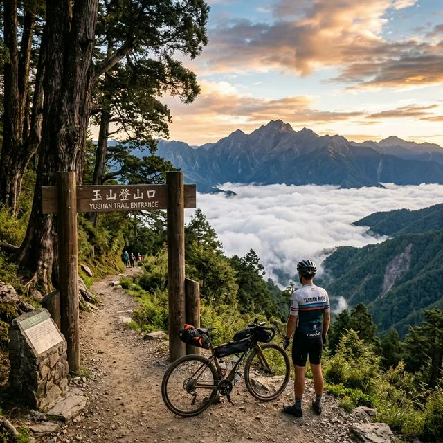
Finish: Tataka Visitor Center (Xinyi Township, Nantou County, elevation approx. 2,610 meters)
Total distance: approx. 28 km
Total elevation gain: approx. 800 m
Highest point: Tataka Saddle (elevation approx. 2,610 meters)
Difficulty: ★★★☆☆ (Moderate, though high-altitude factors must be considered)
Recommended riding time: 2-4 hours (riding only)
Full Route Planning: Starting from Chiayi City
Although the core segment is only 28 km, most cyclists choose to start from Chiayi City, climbing up Provincial Highway 18 (the Alishan Highway) all the way to Alishan before continuing on to Tataka. The full route from Chiayi City to Tataka is about 110 km, with a total elevation gain of over 2,500 meters — this is the complete challenge.
Chiayi City to Shizhuo (approx. 55 km, approx. 1,300 m gain)
Starting from downtown Chiayi, the route follows Provincial Highway 18 continuously upward. The first 30 km consist of gentle rolling hills, and after passing Chukou and Longmei, the road begins to climb into true mountain terrain. Past Xiding (elevation approx. 1,250 meters), you’ll see the famous tea plantations and a spectacular sea of clouds. Shizhuo is an important settlement along the Alishan Highway, with several shops and restaurants — the last well-equipped supply point before continuing up the mountain.
Shizhuo to Alishan (approx. 27 km, approx. 900 m gain)
The segment from Shizhuo to the Alishan Forest Recreation Area is steeper, with an average gradient of 4-5% and sections reaching 7-8%. Along the way you’ll pass Shizilu and Zizhong (Lulin Lodge). Beyond Shizilu, the road enters the cloud belt, where visibility can drop significantly — but this is also one of Alishan’s most captivating features. Riding through the mist, surrounded by towering Japanese cedars and cypress trees, feels like entering a fairyland.
Alishan to Tataka (approx. 28 km, approx. 800 m gain)
This segment is the highlight of the entire route. After leaving the Alishan Forest Recreation Area, the road follows Provincial Highway 21 (the New Central Cross-Island Highway) eastward. The road surface is in good condition, with a wide two-lane carriageway. The first 10 km has some gentle rolling terrain, and by the time you pass Qianshan (in front of Lulin), the elevation is around 2,400 meters. You’ll then pass a breathtaking stretch — on the left side of the road is the bottomless gorge of the Nanzixian River valley, and on the right is a steep mountain wall. On clear days, you can see the main peak of Yushan (玉山) in the distance, its snow-capped summit glinting in the sunlight.
Continuing on, you’ll pass the Husband-and-Wife Trees (although they have since fallen, the site remains a famous landmark) and Lulin Lodge. The final few kilometers of climbing lead to the Tataka Saddle, with a gradient of about 5-6%. Upon arriving at the Tataka Visitor Center, you’ll be standing right at the entrance to the Yushan trailhead. On a clear day, you can see Yushan’s majestic form clearly from the parking area.
Best Season to Ride
This route can be ridden year-round, but the best seasons are October to December and March to April. In autumn, Alishan is graced with beautiful maple foliage and clear skies, and the sea of clouds appears most frequently. Spring brings cherry blossoms and a variety of alpine flowers. Summer afternoons frequently bring thunderstorms, and winter occasionally sees low temperatures and icing brought on by cold fronts. It’s recommended to start early in the morning and finish the climbing sections before noon, avoiding the afternoon weather changes.
Highlights Along the Way
Sea of Clouds: Alishan’s sea of clouds is a world-famous natural spectacle. Between 1,500 and 2,500 meters in elevation, you can often see a magnificent sea of clouds filling the valleys. The best viewing times are early morning and dusk.
Sacred Trees: There are several thousand-year-old sacred trees along the route, the most famous being the Alishan Sacred Tree Grove and the Lulin Sacred Tree. These massive Taiwan red cypress and Taiwan cypress trees have witnessed thousands of years of history.
Railway Relics: The Alishan Forest Railway is an important cultural asset of Taiwan. While riding, you may occasionally see the railway crossing the road, and if you’re lucky, you might even catch a glimpse of the small train passing by.
Yushan Views: From near Tataka, you can clearly see Yushan (玉山, elevation 3,952 meters), the highest peak in Northeast Asia — a view that many cyclists look forward to most.
Precautions
Sections of Provincial Highway 21 (the New Central Cross-Island Highway) occasionally experience rockfall, especially after rain. Loose gravel and slippery moss on the road surface pose potential hazards when descending. UV radiation is strong at high altitude even when the temperature isn’t high, so proper sun protection is essential. In addition, macaques are known to appear along this road — do not leave food exposed while resting, to avoid attracting them.
Related Reading
- Chiayi Alishan to the Yushan Trailhead: An Extreme High-Mountain Climbing Challenge
- Guide to Climbing Tataka: A High-Altitude Challenge at the Foot of Yushan
- Complete Road Conditions from Tataka’s Alishan Side: The 40K Highlight Segment from Alishan to Tataka
- Cycling the Alishan Highway (Provincial Highway 18): A Bike Journey Beneath a Century-Old Scenic Railway
阿里山塔塔加 兩倍特濃版!全新隧道開通! 進喔!公路車 | CT Yeh
3 年前
公路車 | 塔塔加驚險員工旅遊 | 還好手腳快沒被抓交替!
5 年前
里佳部落 阿里山單車深度旅遊! | 竹山/草嶺/來吉/奮起湖 | 無敵銀河絕景 全新路線探索! 驚險狀況百出! | 4K沉浸式畫質 | 公路車 | CT Yeh
3 年前
一定要騎一次!阿里山最深處:里佳部落!單車旅行 | 2800m爬升 | 深度部落體驗:嗨翻晚會、螢火蟲、銀河 | feat. JJSC & 廢物伙伴 | 公路車 CT Yeh
9 個月前
那瑪夏x茶山 阿里山系深山單車行 Day2 累積爬升6000M | 🥶超陡連續下坡 整路看隊友刷 | 爬升一座西進武嶺 | JJSC | 公路車 | CT Yeh
3 年前
嘉義大埔、阿婆灣挑戰賽,美到以為在日本!ft. 環騎5 Cool 西拉雅188 / 公路車 / CT Yeh
7 個月前
藤枝二集團 單車行 Day1 | 南部小武嶺 | 爬坡爬到罵罵叫 | JJSC | 公路車 | CT Yeh
3 年前
半日 小台灣 極限單車路線挑戰實錄
7 年前