Taiwan's High-Altitude Highway Cycling Guide
Taiwan is a mountainous island, with over 200 peaks above 3,000 meters squeezed into an area of just 36,000 square kilometers. Thanks to this, Taiwan boasts numerous paved roads above 2,000 meters in elevation, offering cyclists a world-class high-mountain riding experience. This article will introduce Taiwan's highest road routes one by one, from the highest, Wuling, to the various challenging high-mountain passes.
First Place: Wuling (Elevation 3,275 m)
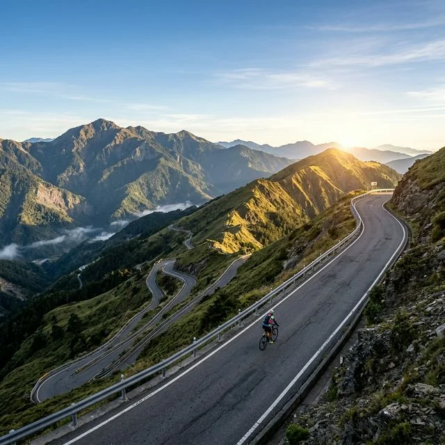
Road: Provincial Highway 14A
Route Options: Puli side (west approach) or Taroko side (east approach)
West Approach Distance: Approximately 55 km (from Puli), with approximately 2,800 m of climbing
East Approach Distance: Approximately 105 km (from Taroko), with approximately 3,275 m of climbing
Wuling is the highest point on Taiwan's roads and also the highest point on roads in Southeast Asia. Provincial Highway 14A begins its climb from Wushe (elevation 1,148 m) all the way to Wuling, a pure climb of about 32 km. The most popular west approach starts from Puli, passing through Wushe and Cingjing before reaching Wuling. The gradient averages 5% on the Cingjing to Cuifeng section, increases to 6% on the Cuifeng to Kunyang section, and the final stretch from Hehuan Mountain Lodge to Wuling is the steepest, with parts exceeding 8%. Riding above 3,000 meters, the air's oxygen content is only 70% of that at sea level, causing heart rate and breathing to rise abnormally. Many cyclists aim to "reach Wuling from the west in under three hours"—a benchmark achievement threshold.
Second Place: Dayuling (Elevation 2,565 m)
Road: Junction of Provincial Highway 8 and Provincial Highway 14A
From the Taroko side: Approximately 80 km, with approximately 2,500 m of climbing
From the Lishan side: Approximately 30 km, with approximately 650 m of climbing
Dayuling is the highest point on the Central Cross-Island Highway and the junction of Provincial Highways 8 and 14A. Attacking Dayuling from the Taroko side in Hualien, a continuous 80 km climb, is an astonishing endurance challenge. Along the way, you pass through Taroko Gorge, primeval forests, and high-mountain cloud belts, offering a richness of scenery changes unrivaled in Taiwan. Dayuling is also the必经之路 for the east approach to Wuling; many cyclists ride all the way from Taroko to Wuling, completing this legendary route known as the "KOM" (King of the Mountain)—the course of the Taiwan KOM Challenge, an international cycling race.
Third Place: Siyuan Pass (Elevation 1,948 m)
Road: Provincial Highway 7A
From the Yilan side: Approximately 70 km (from Yilan City), with approximately 1,900 m of climbing
From the Lishan side: Approximately 30 km, with approximately 100 m of climbing (mostly downhill)
Siyuan Pass is the highest point on Provincial Highway 7A and the watershed divide between the Lanyang River and the Dajia River. The gradient on the route from the Yilan side varies greatly; the first half is relatively gentle (2-3%), but after Siji Elementary School, the gradient noticeably increases to 5-7%. In winter, Siyuan Pass occasionally experiences snowfall, and the road surface may freeze. The route attacking Siyuan Pass from the Yilan side is less traveled by cyclists, but the scenery is serene and traffic is sparse, making it a good choice for those who enjoy quiet riding.
Fourth Place: Yakou/Daguanshan Tunnel (Elevation 2,722 m)
Road: Provincial Highway 20 (Southern Cross-Island Highway)
From the western section (Jiasian side): Approximately 110 km, with approximately 2,500 m of climbing
From the eastern section (Guanshan side): Approximately 90 km, with approximately 2,400 m of climbing
The highest point of the Southern Cross-Island Highway is at Daguanshan Tunnel, at 2,722 meters, making it Taiwan's second-highest road pass. The climb on the Southern Cross-Island Highway is more remote and primitive than Wuling, with very few resupply points and even more uncertain road conditions. The route from the western section (Jiasian) passes through Bunun indigenous villages and spectacular canyon terrain, with the final 35 km from Meishankou to Yakou being a sustained 5-6% gradient. The challenge of the Southern Cross-Island Highway lies not only in the climb itself, but also in its remoteness—cell phone signals are often unavailable, and the nearest medical facility could be tens of kilometers away.
Fifth Place: Tataka Saddle (Elevation 2,610 m)
Road: Provincial Highway 21 (New Central Cross-Island Highway)
From the Chiayi side: Approximately 95 km, with approximately 2,500 m of climbing
From the Shuili side: Approximately 70 km, with approximately 2,300 m of climbing
Tataka is the highest point on the New Central Cross-Island Highway and the location of the trailhead for Yushan (Jade Mountain). From the Chiayi side, follow Provincial Highway 18 through Alishan, then connect to Provincial Highway 21 to reach Tataka, covering approximately 95 km in total. This route is characterized by passing through multiple distinct forest zones—from low-elevation bamboo groves, mid-elevation cypress forests, to high-elevation hemlock and fir forests. The section from Alishan to Tataka offers particularly magnificent views, and on clear days, you can see the main peak of Yushan in the distance.
General Guide for High-Altitude Riding
Acclimatization
The biggest challenge of high-altitude riding is hypoxia. At 3,000 meters, the partial pressure of oxygen in the air is only about 70% of that at sea level. This means that at the same exercise intensity, your heart rate will be 15-25% higher than at sea level, and your breathing rate will increase by more than 30%. It is recommended to maintain your power or heart rate at 70-80% of your sea-level threshold during the climb. Do not attempt to set personal bests at high altitude; respect your body's signals.
Preventing Altitude Sickness
Acute Mountain Sickness (AMS) typically begins to appear above 2,500 meters. Symptoms include headache, nausea, dizziness, loss of appetite, and insomnia. Prevention methods include: adequate fluid intake (at least 500 ml per hour), avoiding rapid gains in elevation, and not engaging in strenuous exercise immediately after reaching a high point. If symptoms worsen, the only effective treatment is to descend immediately.
Temperature Management
Temperature differences in Taiwan's high mountains are extreme. It could be 30°C at the base and only 5°C at the summit. For every 100 meters of elevation gain, the temperature drops approximately 0.6°C. While climbing, your body generates a lot of heat, and a short-sleeve jersey might suffice, but the moment you stop or start descending, the perceived temperature drops sharply. Layering is recommended: a moisture-wicking base layer + an insulating mid-layer (thin fleece or wool) + a windproof outer layer (lightweight windbreaker). Full-finger gloves and a head cover are almost essential above 2,500 meters.
Equipment Selection
Gear ratio selection is crucial for mountain riding. A gear combination of at least 34x32 is recommended (for road bikes); for long-distance climbs, you might even consider 34x34 or lower. In a hypoxic environment, maintaining a high cadence (80-90 rpm) is more efficient than grinding a low cadence with high force. Slightly wider tires (28-30c) can be chosen for better comfort and downhill stability.
Best Season
The best seasons for riding Taiwan's high-mountain roads are March to May and September to November each year. Spring brings blooming flowers, and autumn offers crisp, clear weather. Summer is warm but has frequent afternoon thunderstorms and is also typhoon season. In winter (December to February), cold snaps can bring snow to the high mountains, and roads may be closed. Regardless of the season, it is advisable to complete the climb in the morning and begin descending before the weather changes in the afternoon.
Taiwan's high-mountain roads are the most precious gift this island offers to cyclists. Few places in the world allow you to climb from sea level to over 3,000 meters in such a short distance. Each route has its own unique character and challenges, worthy of exploration and experience time and again. Prepare your climbing gears, and set off toward Taiwan's skyline.
Related Reading
- Taiwan’s Top Ten Classic Road Cycling Climb Routes
- Taiwan’s Hundred Peaks Challenge Route Guide: Complete Guide to Riding Wuling and the Hehuan Mountain Highway
- Taiwan High-Mountain Road Challenges: Preparation Strategies for Wuling, Hehuan Mountain, and Dayuling
- Taking on Taiwan’s Five Classic Climbs: Wuling, Tataka, Alishan, Hehuan North Peak, and Taipingshan
#北橫 + #北進武嶺 最硬的員工旅遊 EP1 | #公路車 #拉拉山 | 明池 | 武嶺 | 武陵農場 | 雲海 | Taiwan Cycling Route Wulin
6 年前
台灣登山王之路 KOM 全程參賽4K臨空錄影 PART1 穿越峽谷地形! #東進武嶺 太魯閣 / 燕子口 / 天祥 / 西寶 PART1 (公路車 / CT Yeh)
3 年前
西進武嶺最新路況場勘,台14到清境,還適合騎單車上去嗎?/ 居然有這優勢!?/請開啟字幕/當天現剪/公路車/CT Yeh
2 年前
大禹嶺 到 武嶺牌樓 全程前後實況錄影 | 北進武嶺 | 東進武嶺 | KOM | 訓練台 | 坡度分析 | Taiwan KOM Last 10 km HARD | 公路車
6 年前
藤枝二集團 單車行 Day1 | 南部小武嶺 | 爬坡爬到罵罵叫 | JJSC | 公路車 | CT Yeh
3 年前
日本公路最高登山賽,台灣首位YT挑戰實錄,乘鞍登山賽40週年,賽前篇完整版,請到我的YT收看 #公路車 #cycling
11 個月前
大武山20%魔王陡坡【JJSC南台灣遊騎Day2】!屁股真的要裂開了...凡士林抹滿也沒用?神秘金教堂還有超便宜夜市
3 個月前
台北闊瀨陡坡 騎旅 / 日本單車雜誌編輯車友臨時加入!/ 髮香才是最強的 / feat. 北迴歸線小隊 / 公路車 CT Yeh
6 個月前