Cycling After Xiuguluan River Rafting: A Cross-Country Ride from Ruisui to Fengbin on the East Coast
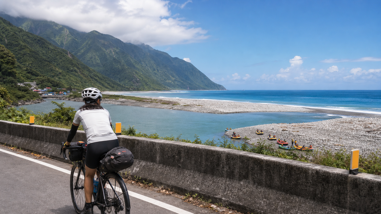
Cycling after Xiuguluan River Rafting: An East Coast Ride from Ruisui, Hualien to Fengbin
The Xiuguluan River is Taiwan’s most important rafting river, attracting hundreds of thousands of visitors each year who set off from Ruisui and drift downstream to Jingpu in Fengbin Township, where the river meets the Pacific Ocean. The full rafting route covers about 24 kilometers, passing through the Hualien Longitudinal Valley and into the gorge section of the Coastal Mountain Range—one of Taiwan’s most spectacular natural experiences.
However, few people discuss the cycling itinerary after rafting: starting from Jingpu in Fengbin, heading south along Provincial Highway 11 to Chenggong in Taitung, or heading north back to Hualien City. This route is the most scenic southern section of the East Coast Highway, offering breathtaking views.
This article provides a complete “rafting + cycling” itinerary plan, so that a trip to the Xiuguluan River doesn’t just end with rafting, but extends into an in-depth East Coast journey.
Xiuguluan River Rafting Basic Information
| Item | Details |
|---|---|
| Rafting Start | Ruisui Bridge, Ruisui Township |
| Rafting End | Jingpu Fishing Harbor, Fengbin Township |
| Rafting Distance | Approx. 24 km |
| Rafting Time | Approx. 3–4 hours (including lunch break) |
| Cost | Approx. NT$800–1,200 per person |
| Operators | Multiple rafting operators in Ruisui; shuttle services available |
Cycling Routes After Rafting
Route A: Fengbin → Jingpu → South → Chenggong, Taitung (approx. 75 km)
This is the highlight section of the East Coast Highway. From the Xiuguluan River estuary heading south along Provincial Highway 11 to Chenggong, Taitung, the scenery includes:
Jingpu (0 km)
The rafting endpoint, where the Xiuguluan River meets the Pacific Ocean. Here you can see the confluence of river and sea water, fishing boats docked, and the daily life of the Amis fishing village.
Shibilan Island (approx. 5 km)
A small island beside Provincial Highway 11. At high tide it stands isolated in the sea; at low tide you can walk across to the island. It is one of the few reef islands on the East Coast.
Jici Beach (approx. 15 km)
One of the most beautiful beaches on the East Coast, backed by the towering Coastal Mountain Range and facing the Pacific Ocean. Open for swimming in summer, crowded during peak tourist season.
Baqi Lookout (approx. 20 km)
One of the most famous viewpoints along Provincial Highway 11. From here you can overlook a vast expanse of the Pacific Ocean and the majestic Coastal Mountain Range.
Chenggong Township (approx. 75 km)
An important town at the northern end of Taitung County, famous for bluefin tuna. The fishing harbor market offers fresh seafood.
Route B: Fengbin → North → Hualien City (approx. 60 km)
Heading north from Jingpu, take Provincial Highway 11C and connect to Provincial Highway 11 back to Hualien City. The scenery along this route is somewhat similar, but there are several unique attractions:
Fangliao Trail (approx. 10 km)
A trail within the traditional territory of the Amis people, offering views of the natural vegetation of the Coastal Mountain Range along the way.
Changhong Bridge (approx. 20 km)
Taiwan’s first prestressed concrete arch bridge, spanning the Xiuguluan River. With its elegant shape, it is a famous landmark in Hualien.
Hualien Harbor (approx. 60 km)
The core city of Hualien. Upon reaching here, you can choose to stay overnight or take the TRA train back to Taipei.
Amis Cultural Experiences Along the Way
The Xiuguluan River basin is the traditional territory of the Amis people. Along the cycling route after rafting, there are many opportunities for in-depth Amis cultural experiences:
| Cultural Experience | Location | Description |
|---|---|---|
| Traditional Fishing | Jingpu Fishing Village | Observe stone-trap fishing methods |
| Wild Vegetable Gathering | Fengbin Tribe | Amis wild vegetable culture workshop |
| Tribal Guided Tour | Jici Tribe | Listen to tribal history and myths |
| Harvest Festival | Various tribes (July–August) | The most important annual ceremony |
Resupply Plan
| Location | Resupply Options |
|---|---|
| Jingpu Fishing Village | Local village shops with basic food and drinks |
| Jici (approx. 15 km) | Beverages available near the beach |
| Mid-section between Jingpu and Chenggong | Sparse resupply points; bring your own supplies |
| Chenggong Township (75 km) | Full resupply with convenience stores and restaurants |
Integrated Itinerary Suggestions
Three-Day East Coast Itinerary:
Day 1: Depart from Hualien City, take the TRA train to Ruisui (bringing your bicycle), stay overnight in Ruisui
Day 2: Raft in the morning (departing at 8:00 AM), cycle south from Jingpu in the afternoon (approx. 35 km to Jici), stay overnight in Jici
Day 3: Continue cycling south to Chenggong (40 km), take the TRA train back to Taipei
Notes
- After rafting, your body may feel slightly fatigued; it is recommended to keep the afternoon cycling distance within 40 km
- Traffic on Provincial Highway 11 is heavy during the summer peak season; the earlier you depart, the better
- Resupply points are scarce between Jingpu and Fengbin; make sure to stock up on water at Jingpu Fishing Village
- Weather: Autumn (September–November) on the East Coast offers the best weather after typhoons; spring (March–May) is also a good choice
Conclusion
The “rafting + cycling” East Coast combination trip lets you experience both the rushing rapids of Taiwan’s mountain rivers and the serene grandeur of the Pacific coast in a single journey. From the rubber raft in Ruisui to the bicycle in Fengbin, the transition itself becomes a memorable part of the trip.
Let the Xiuguluan River carry you to the sea, then let Provincial Highway 11 take you onward.
Related Reading
- Hualien Coastal Highway Cycling Journal: Blue Skies, Blue Seas, and Tribal Charm on Provincial Highway 11
- Taitung Coastal Highway Cycling: The Most Beautiful Riding Scenery on the East Coast
- Hualien Cycling: Pacific Bikeway and the Best of the Huadong Longitudinal Valley
- Complete Guide to Taiwan’s Northeast Coast Golden Coastline Cycling Route
藤枝二集團 單車行 Day1 | 南部小武嶺 | 爬坡爬到罵罵叫 | JJSC | 公路車 | CT Yeh
3 年前
山道猴出沒!? JJSC屏東單車行 Day1 一直催 / 皮卡丘來了!/ 墾丁 旭海 恆春 社頂 / 公路車 / CT Yeh
2 年前
日本自助單車旅,茨城絕景路線/ 新手也可以體驗 / 4K空拍絕景 / 機票省錢大法 / 單車友善旅館 / 國家級霞之浦180K自行車道 / feat. 緯緯 / CT Yeh
1 年前
大武山後門26%歡樂陡坡!JJSC南台灣單車行Day2 / 被颱風追著跑 / 公路車 / CT Yeh
2 年前
太平山單車員工旅遊 | 這樣玩CP值最高!| 公路車
5 年前
大武山20%魔王陡坡【JJSC南台灣遊騎Day2】!屁股真的要裂開了...凡士林抹滿也沒用?神秘金教堂還有超便宜夜市
3 個月前
觀霧 變好騎了! | 北高車友爆笑大會師 | 公路車 | 單車旅遊 Taiwan Cycling Route GuanWu
6 年前
里佳部落 阿里山單車深度旅遊! | 竹山/草嶺/來吉/奮起湖 | 無敵銀河絕景 全新路線探索! 驚險狀況百出! | 4K沉浸式畫質 | 公路車 | CT Yeh
3 年前