文章導覽
- Introduction: Nature's Ultimate Showcase
- Classic Route: Christchurch to Queenstown
- Route Overview
- Stage 1: Christchurch → Ashburton | Approximately 90 km
- Stage 2: Ashburton → Lake Tekapo | Approximately 160 km
- Stage 3: Lake Tekapo → Lake Pukaki → Mount Cook Village | Approximately 70 km
- Stage 4: Mount Cook Village → Omarama → Lindis Pass | Approximately 120 km
- Stage 5: Lindis Pass → Wanaka → Queenstown | Approximately 120 km
Epic Cycling Adventure in New Zealand’s South Island: Pedaling Through Middle-earth
Introduction: Nature’s Ultimate Showcase
If you’ve ever been awestruck by the landscapes in The Lord of the Rings films, then a cycling trip through New Zealand’s South Island will be a real adventure that surpasses the silver screen. The South Island covers approximately 150,000 square kilometers (about 4.2 times the size of Taiwan), yet has a population of less than 1.2 million. This means most roads are so quiet they feel like your own private driveway.
The dramatic diversity of the South Island’s terrain is staggering: the west coast features humid temperate rainforests with annual rainfall exceeding 6,000 millimeters; the east coast is the dry Canterbury Plains; the center is dominated by the towering Southern Alps (with the highest peak, Aoraki/Mount Cook, at 3,724 meters); and the southern tip is home to deep fjords and primeval forests. A lap around the South Island by bike is like experiencing several different countries in a single journey.
Classic Route: Christchurch to Queenstown
Route Overview
- Total Distance: Approximately 500 km
- Recommended Duration: 7-10 days
- Total Elevation Gain: Approximately 4,000 meters
- Difficulty: Moderate to challenging
- Best Season: December to March (Southern Hemisphere summer)
This route departs from Christchurch, the South Island’s largest city, crosses the Canterbury Plains, traverses the Southern Alps, and follows stunning lakes all the way south to Queenstown—the adventure capital of the South Island.
Stage 1: Christchurch → Ashburton | Approximately 90 km
After leaving Christchurch, you immediately enter the vast Canterbury Plains. This is New Zealand’s breadbasket, where golden wheat fields and lush green pastures unfold alternately, with the snow-capped silhouette of the Southern Alps in the distance. This stretch is almost completely flat, but strong northwesterly or southerly winds are common. With a tailwind, you’ll feel like the fastest cyclist in the world; against a headwind, you’ll question why you ever came here.
Stage 2: Ashburton → Lake Tekapo | Approximately 160 km
This section begins to get undulating. After leaving the plains, the road gradually climbs into the Mackenzie Basin. The moment you arrive at Lake Tekapo is the first highlight of the entire journey—the lake’s water displays an incredible turquoise color, caused by glacial rock flour suspended in the meltwater, refracting this unique hue.
Lake Tekapo is also a renowned Dark Sky Reserve, and the night sky here is so spectacular it can bring you to tears. If the weather is clear, you can clearly see the Milky Way stretching across the sky, with the Southern Cross twinkling on the horizon. This is an experience you could never have in any city.
Stage 3: Lake Tekapo → Lake Pukaki → Mount Cook Village | Approximately 70 km
The distance from Lake Tekapo to Lake Pukaki is only about 40 kilometers, but the scenery along this stretch will make you stop for photos every few hundred meters. Lake Pukaki’s water is even more vividly blue than Lake Tekapo’s, and at the head of the lake stands New Zealand’s highest peak—Aoraki/Mount Cook.
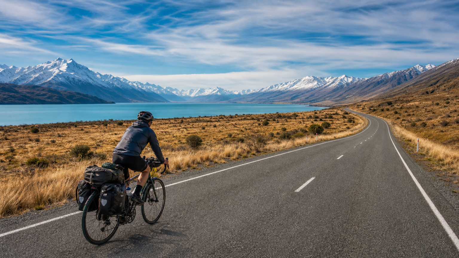
From the shores of Lake Pukaki, turn onto State Highway 80 and ride 30 kilometers along the lakeside to Mount Cook Village. This is one of the most awe-inspiring sections of the entire journey: on your left, azure blue water stretches to the horizon; directly ahead, the snow-covered peaks of Mount Cook dominate the view, with the road pointing straight toward that icy world. It’s recommended to stay overnight in Mount Cook Village and hike the Hooker Valley Track to experience the glacier’s grandeur up close.
Stage 4: Mount Cook Village → Omarama → Lindis Pass | Approximately 120 km
From Mount Cook Village, return to State Highway 8 and continue south. Omarama is a peaceful town known for stargazing and gliding. From here, you’ll face the biggest climbing challenge of the trip—Lindis Pass (971 meters). Although the elevation isn’t particularly high, the sustained ascent combined with strong plateau winds can really take a toll on you.
However, the descent after crossing Lindis Pass is a reward worth cheering for. The road winds downward through dry golden grasslands, with distant mountains displaying fantastical shades of orange, brown, and purple—this is the unique landscape characteristic of Central Otago.
Stage 5: Lindis Pass → Wanaka → Queenstown | Approximately 120 km
Wanaka is a resort town surrounded by snow-capped mountains and lakes, and many riders choose to rest here for a day or two. The famous “Wanaka Tree,” standing alone in the lake, is one of New Zealand’s most iconic photo spots.
There are two route options from Wanaka to Queenstown. The recommended choice is the Crown Range Road, which is New Zealand’s highest sealed road (1,076 meters). The views of Arrowtown and Lake Wakatipu from the summit are absolutely magnificent. The final descent leads directly into Queenstown, bringing your journey to a perfect conclusion in the vibrant atmosphere of this adventure capital.
New Zealand’s Official Great Rides Cycle Trails
In addition to road cycling, the New Zealand government has invested in developing a network of official off-road cycle trails, collectively known as Ngā Haerenga – New Zealand Cycle Trail. Several outstanding routes stand out on the South Island:
- Alps 2 Ocean Trail: From Mount Cook to Oamaru, 300 kilometers in total
- Otago Central Rail Trail: Built along a disused railway line, 152 kilometers in total
- West Coast Wilderness Trail: Through the West Coast rainforest, 132 kilometers in total
Practical Tips
Weather
New Zealand is famous for experiencing “four seasons in one day.” Even in summer, temperatures in mountainous areas can drop suddenly. Be sure to carry windproof and waterproof outerwear, and keep a close eye on weather forecasts.
Supplies
Towns on the South Island are far apart, especially in the Mackenzie Basin and Central Otago regions, where supply points can be 80-100 kilometers apart. Make sure to carry enough food and water before setting out.
Wildlife
During your ride, you may encounter New Zealand’s native birds, including the mischievous Kea (mountain parrot)—these intelligent birds might curiously peck at your panniers. In the fjordland region, sandflies are a nuisance, so remember to apply insect repellent.
Accommodation
The Department of Conservation (DOC) maintains numerous campsites and huts across the country at low cost (NZ$5-15 per night). Combined with YHA hostels and various B&Bs, there’s a wide range of accommodation options.
Conclusion
A cycling trip through New Zealand’s South Island is the most profound conversation you can have with nature. Here, you’ll be awed by the ancientness of glaciers, captivated by the colors of the lakes, moved by the vastness of the starry sky, and humbled by the power of the wind. At the end of each day, your legs may be exhausted, but your soul will be filled to the brim with the magnificence of this land.
Middle-earth isn’t fictional—it’s right here, waiting for you to pedal, explore, and experience it.
Related Reading
- Queenstown, New Zealand’s South Island: A Cycling Resort Paradise in the Southern Hemisphere
- Cycling Around Orchid Island: The Majestic Scenery and Local Culture of an Offshore Island Highway
- Taiwan Cycling Loop Southern Route: A Tropical Riding Experience from Pingtung to Taitung
- Tasmania Cycling Exploration: A Primitive Riding Journey Through Australia’s Last Frontier