Wujie Industrial Road Climbing Guide: Gear Ratio and Pacing Strategy for a Sustained 7.8% Gradient
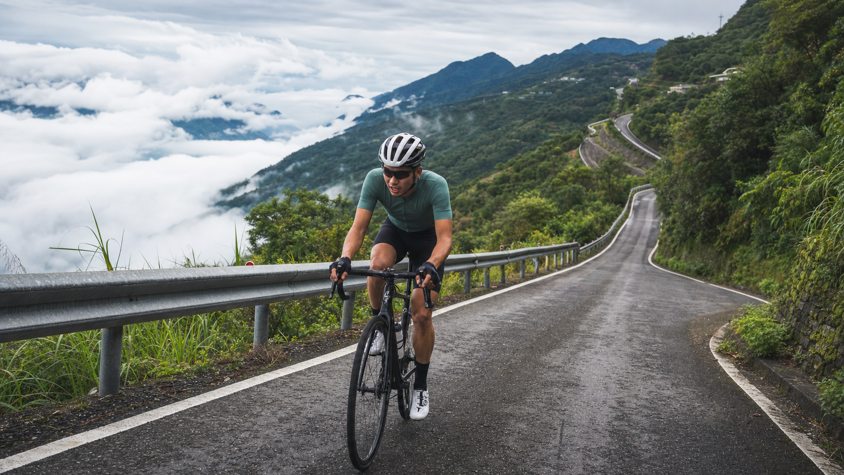
The Wujie Industrial Road is the access climb to Fazhi Village (Wujie Tribe) in Ren’ai Township, Nantou County. It stretches approximately 9.5 kilometers with about 767 meters of elevation gain and an average gradient of 7.8%, classified as a Category 4 climb on Strava. The Wujie Tribe sits at an elevation of roughly 760 to 820 meters, making it the northernmost settlement of the Bunun people’s Take-todo (卓社群) group. Known for its year-round sea of clouds and cloud waterfalls, it is called the “Hometown of Clouds” and “God’s Canvas.”
A 7.8% average gradient is completely different from a route like Sun Moon Lake, where steep sections are “diluted” by flats—Wujie is almost a continuous climb “from start to finish,” with little flat terrain to catch your breath. This is an honest, unforgiving tribal industrial road. This article takes an engineer’s perspective, breaking down these 9.5 kilometers to tell you what gear ratios to bring, how to pace yourself, and where things can go wrong.
Route Overview: First, Understand the Continuity of the 7.8% Grade
| Item | Data |
|---|---|
| Distance | Approximately 9.5 km |
| Total Elevation Gain | Approximately 767 m |
| Average Gradient | 7.8% |
| Strava Category | Category 4 |
| Tribe Elevation | Approximately 760–820 m |
A 7.8% average gradient means: for every 100 meters of horizontal distance, you climb nearly 8 meters. A short section of this gradient isn’t hard—what’s hard is “nearly 9.5 kilometers with almost no relief.” For comparison—most people find 5–6% gradients challenging, while 7.8% enters the range where “you must seriously manage your heart rate and gear ratios.” If you misallocate your energy, you can easily blow through your leg strength in the middle section.
To quantify the scale of this route another way: with 767 meters of climbing over 9.5 kilometers, a typical enthusiast with a power-to-weight ratio of about 3 W/kg will need roughly 40 to 60 minutes of sustained aerobic output for the entire climb. For riders whose only goal is to “finish,” this stretch is closer to a 60 to 90-minute marathon of willpower. The key number isn’t “how steep it is,” but “how long it stays steep”—the real difficulty of Wujie lies in the word “continuous.” Compared to a sawtooth route like Sun Moon Lake, where flats dilute the steep sections, Wujie is an almost uninterrupted straight-line climb with no recovery windows. Once you make a pacing mistake, there’s no flat section to earn your strength back.
The main access route is County Road 71 (from Puli toward Wujie), passing through the Zhuoshe Tunnel (opened around 2006, built by Taiwan Power Company by cutting through Wujie Mountain to straighten the road). After this tunnel, you truly enter the steep industrial road leading to the Wujie Tribe.
Using Power/Heart Rate to Break the 9.5 km into “Manageable” Segments
When facing a continuous steep climb, the worst thing is to “pedal by feel.” If you have a power meter or heart rate strap, it’s strongly recommended to “quantify” the entire climb using the zones below, holding your upper limits throughout so no short steep section drags you into anaerobic debt:
| Segment Type | Target Power Zone (% FTP) | Target Heart Rate Zone (% HRmax) | Cadence |
|---|---|---|---|
| County Road 71 Warm-up | 60–70% | 68–74% | 80–85 rpm |
| Climb Around Zhuoshe Tunnel | 75–88% | 78–82% | 72–80 rpm |
| Sustained Steep Cruise | 85–95% | 82–87% | 65–75 rpm |
| Brief Steepest Critical Points | 100–110% (short bursts) | 87–90% | 55–65 rpm |
The key is the “cruise” row. Wujie isn’t won by short bursts of power, but by the endurance to “hold a steady output near your threshold for over 40 minutes.” Your goal isn’t how fast you ride any one section, but to never exceed the red line that will blow you up for the entire climb. Once your heart rate stays above 90% for an extended period, lactate clearance can’t keep up with accumulation, and a mid-climb collapse is almost inevitable.
Segment Guide 1: County Road 71 Warm-up
The front section of County Road 71 from the Puli direction is the transition before entering the core steep climb. The gradient here is still relatively manageable—this is where you settle your breathing, confirm your gear ratios, and get your nutrition in place.
- Gear Ratio: Use the middle chainring with a mid-range cassette gear, maintaining a comfortable cadence of 80–85 rpm.
- Heart Rate: Keep it around 70% of your max heart rate. Don’t push here; save your strength for what’s ahead.
- Key Actions: Check your water bottles, nutrition, gloves, and brake feel, because once you enter the tribal steep climb, there’s no time to adjust.
Segment Guide 2: The Climb Around Zhuoshe Tunnel
After passing the Zhuoshe Tunnel area, the road starts to pull up noticeably. This is the critical transition point in gradient—from “still able to chat” to “only able to focus on pedaling.” The Zhuoshui River flows through here in a crescent bend, dividing Wujie into the Jieshan Tribe on the west bank and the Yuanshan Tribe on the east bank. Topographically, you can feel the road spiraling up along the mountainside of the river valley.
- Gear Ratio: Shift to a larger rear cog (25–28 teeth) early. Change gears before you need to, don’t wait until you can’t turn the pedals and start fumbling.
- Pedaling Rhythm: Keep your cadence above 70 rpm, using “smooth, round power” instead of “mashing” to protect your knees.
- Pacing: Here, you should settle into your climbing cruise heart rate for the day (around 78–82% of max heart rate) and maintain it steadily.
Segment Guide 3: The Sustained Steep Climb to the Tribe (Hardest Section of the Route)
Entering the core industrial road to the Wujie Tribe, the 7.8% average gets magnified into a series of real steep pitches, with localized gradients even steeper. This is where the route truly tests your willpower and gear ratios.
- Strategy: Use a “seated-first, standing-assist” approach. On long steep sections, stay seated and grind with a low gear. Only stand up for two or three pedal strokes to crest sudden steeper pitches, then sit back down immediately. Standing and mashing the entire 9.5 kilometers is suicide.
- Heart Rate Management: Allow brief spikes to 85% of max heart rate on the steepest sections, but actively lower your heart rate and take deep breaths on the occasional slightly flatter stretches.
- Common Mistakes and DNF Risk: The most common reason people “blow up” is going out too fast in the early sections. The continuous 7.8% grade will honestly settle the account for all the energy you overspent earlier. Once lactate builds up mid-climb and your cadence drops below 50 rpm, a collapse and dismount become very likely. Better to go slower the whole way than to start fast and blow up later.
Gear Ratio Reference Table: The Lifeline for Continuous Steep Climbs
On a continuous climb starting at 7.8% with steeper local sections, gear ratios aren’t a question of “comfort”—they’re a question of “whether you can make it up or not.” Using a climbing-friendly Sub-compact 48/32 crankset paired with an 11–34T cassette as an example, here are recommended combinations:
| Gradient Range | Recommended Chainring | Recommended Rear Cog | Target Cadence | Notes |
|---|---|---|---|---|
| 3–5% (warm-up gentle climb) | 48 or 32T | 19–23T | 82 rpm | Shift to small ring early, don’t grind it out |
| 5–7% (noticeable climb) | 32T small ring | 23–27T | 75 rpm | Enter climbing heart rate, hold steady |
| 7–9% (sustained steep) | 32T small ring | 27–32T | 68–74 rpm | Protect knees, lighter is better than heavier |
| 9%+ (critical short pitches) | 32T small ring | 32–34T | 55–65 rpm | Grind steadily in the largest gear |
A very practical piece of advice: If your fitness is average, by all means bring a 34T or even larger cassette. On a 9.5-kilometer continuous climb, “not having a light enough gear” can’t be overcome by willpower—when your cadence is forced below 50 rpm, knee strain skyrockets, lactate accumulates rapidly, and a DNF is only a matter of time. On a climbing route, it’s better to have too much gear range than too little.
Braking and Long Descent Techniques: The Return Trip Is the Real Test
Many people treat Wujie as an “uphill challenge,” forgetting that every meter you climb must be paid back on the descent. A continuous 9.5-kilometer descent with 767 meters of elevation drop is a severe test of both your braking system and your focus:
| Scenario | Correct Approach | Common Mistakes |
|---|---|---|
| Long descent heat management | Intermittent braking, alternating front and rear wheels | Continuous dragging, brake fade |
| Front/rear brake ratio | Front primary, rear assist, applied in intervals | Grabbing the front brake hard, locking the front wheel |
| Consecutive corners | Brake on straights, release in corners, accelerate out | Braking hard mid-corner, losing control |
| Industrial road surface | Anticipate gravel, potholes, leaves, moss | Riding industrial roads at paved-road speeds |
| Wet, foggy mornings | Reduce speed overall, increase braking distance | Pushing on based on dry-road experience |
Disc brakes have a clear advantage on this kind of long, steep descent—better heat dissipation, stable braking in wet conditions, and linear modulation. If you’re on rim brakes, you must brake more frequently in “intermittent” fashion on long descents to let the rim cool, avoiding blowouts or brake fade.
Gear and Equipment Recommendations
Facing a continuous 7.8% climb, gear ratios are the lifeline:
| Equipment Item | Recommendation |
|---|---|
| Crankset | Sub-compact 48/32 or Compact 50/34; for average fitness, the lighter the better |
| Cassette | Largest cog 32T minimum; for heavier riders or average fitness, 34T recommended |
| Tires | 28c or wider; tribal industrial road surfaces aren’t always smooth, wider tires are more stable |
| Brakes | Disc brakes preferred; better heat dissipation and control on the long steep descent back |
| Nutrition | At least two bottles of water; resupply points in the mountains are scarce |
Key Reminder: The hiking routes from Wujie to Yixiantian (One-Line Sky) and Momona’er Waterfall are mostly riverbeds and stream crossings—those are “walking-only秘境,” not cycling surfaces. When planning your trip, be sure to distinguish between “rideable industrial roads” and “must-hike scenic spots.” Don’t ride your road bike into the riverbed.
Nutrition, Hydration, and Seasons
The Wujie Tribe offers tribal cuisine and local agricultural products for resupply, but resupply points along the mountain route are scarce. Make sure to bring enough water and nutrition before heading up. As for specific shops, it’s best to choose based on the situation when you arrive; no specific restaurants are presupposed here.
Seasonally, Wujie is famous for its sea of clouds and cloud waterfalls. The sunrise sea of clouds in the early morning is a signature sight, which also means the road surface is often damp in the morning and visibility is affected by fog. In summer, afternoon thunderstorms and rockfall risks are common in the mountains. It’s recommended to start early and complete the climb and descent before noon.
Nutrition Schedule: No Convenience Stores in the Mountains
Resupply points along the Wujie route are scarce, and this must be written into your trip plan. Assuming “about 1–1.5 hours of continuous climbing,” here’s a suggested nutrition rhythm:
| Time Point | Action | Content Suggestion |
|---|---|---|
| 30 min before departure | Hydrate + carbs | 300–500 ml water, moderate carbs as a base |
| Before entering the steep climb | Pre-fuel | No free hands on the steep sections; eat and drink first |
| Every 20–25 minutes | Small sips of water | One or two mouthfuls, during slightly flatter sections |
| Every 40 minutes | Carb intake | Energy gel / small snack to maintain blood sugar |
| Arrival at the tribe | Full resupply stop | Tribal cuisine, local products, rest |
Principle: Better to carry one extra bottle of water. Sweat loss is high on a continuous climb, and resupply is nearly impossible in the mountains. Dehydration during high-intensity climbing will rapidly tank your performance and can even trigger cramps.
Weather Risk Levels: Mountain Red Lines Are Tighter Than on Flat Ground
| Risk Level | Weather Conditions | Recommendation |
|---|---|---|
| Green (rideable) | Sunny to partly cloudy, no rain, good visibility | Start as planned, take advantage of the early morning |
| Yellow (caution) | Heavy morning fog, slightly damp road, thickening clouds | Start early, complete the climb and descent by noon |
| Orange (conservative) | Scattered showers, reduced visibility, occasional rockfall | Shorten the ride, slow the descent, be ready to turn back |
| Red (do not ride) | Thunderstorms, heavy rain, dense fog, high rockfall risk | Cancel outright; mountain thunderstorms plus rockfall are extremely dangerous |
Mountain weather changes faster and with more severe consequences than on flat ground. Afternoon thunderstorms, rockfall, and landslides are not rare in the Wujie area. Treat “complete the climb and descent before noon” as an iron rule. Don’t gamble your safety for scenery.
Training Recommendations for Wujie
The physical demands of Wujie are very straightforward: long-duration, threshold-adjacent, steady-output climbing endurance. Here’s how to structure your training:
- Long Climb Endurance: Find a continuous climb of 20–40 minutes and ride it steadily at an intensity just below threshold. This trains exactly what Wujie needs most: “sustained pace without fading.”
- Threshold Intervals (FTP): 2×20 minutes or 3×15 minutes at threshold intensity to raise the climbing power you can hold steadily.
- Low-Cadence Strength: Deliberately climb with a heavy gear at low cadence (50–60 rpm) to build muscular endurance for when you’re forced into low cadence on truly steep pitches.
- Weight Management: Climbing performance is directly tied to power-to-weight ratio (W/kg). Losing weight is sometimes more effective than gaining power—this is the most practical lesson on a pure climbing route.
Common Mechanical Issues and Pre-Ride Checks
A continuous steep climb is a severe stress test for your bike, and pre-ride checks are absolutely worth the extra time:
- Brake System: Long descents are hardest on brakes. Before departure, confirm brake pad thickness, hydraulic feel (disc brakes), or brake pads and rim surface (rim brakes). Don’t turn the return trip into a gamble.
- Shifting and Chain: High-load shifting on steep climbs is the most common cause of chain drops and skipping. Run through the full range of front and rear shifts before departure to confirm smoothness, and lube the chain.
- Tire Pressure and Tread: Industrial road surfaces vary. Don’t inflate tires too high to improve grip and comfort, and check the tread for embedded stones or cuts.
- Pedals and Cleats: With frequent steep-start and emergency stops, confirm your cleats engage and release smoothly, allowing quick disengagement when needed, to avoid low-speed cleat-related falls.
Target Times for Different Rider Levels (Reference for the 9.5 km Core Section)
| Rider Level | Gear Strategy | Reference Completion Time |
|---|---|---|
| Goal is just to finish | Grind in low gears the whole way, stop as needed | 90+ minutes |
| General fitness | Steady climbing heart rate, shift down on steep pitches | 60–75 minutes |
| Advanced enthusiast | Cruise at threshold, stand on short steep pitches | 45–55 minutes |
| High-intensity rider | Push threshold power the entire way | 35–45 minutes |
Riding Strategies for Different Weather
The same stretch of Wujie is a different difficulty—even a different risk level—in sunny versus rainy conditions:
- Clear and Dry: Best road grip. You can push your climbing cruise as planned, but pay more attention to hydration and sun protection. Mountain sun is direct and dehydration risk is high.
- Morning Fog and Damp: Poor visibility and a wet road. The climb is less affected, but descent risk increases dramatically—slow down significantly on the return, increase braking distance, and watch for moss on the inside of corners.
- After a Shower: Seepage from the hillside, leaves, and gravel get washed onto the road. Anticipate these obstacles when cornering and descending. If you see signs of a landslide, turn back rather than push on.
- Sudden Fog: Mountain fog can roll in extremely fast. If visibility drops suddenly, turn on your rear light, pull over and slow down. If necessary, stop in a safe spot and wait for the fog to lift. Don’t force a descent in dense fog.
Safety and Tribal Etiquette
Wujie is a living Bunun tribal community, not just a riding venue. When entering the tribe, slow down, yield to residents and children, and respect local routines and culture. Attractions like Siyuan Suspension Bridge, Wujie Reservoir (with its Turkish-blue “milk lake” feel), and Yixiantian each have their own access rules. Before visiting, it’s recommended to confirm their opening status and safety advisories. This is a hardcore climbing route, but a rider’s courtesy and respect for the tribe matter more than any timed record.
Debunking Common Myths: What Riders Most Often Misjudge About Wujie
Continuous steep climbs are the easiest routes to judge by “feel,” and feel is often wrong. Here are the most common misjudgments when planning a Wujie trip:
- Myth 1: “The average gradient is 7.8%, and I can ride 8% short climbs, so I should be fine.” Wrong. An 8% short climb tests instantaneous muscular strength; Wujie tests the endurance to “hold near threshold for 9.5 continuous kilometers.” These are completely different abilities. Many people can easily clear a 300-meter 8% pitch but collapse mid-climb on Wujie—this is exactly why.
- Myth 2: “As long as my gear ratio is light enough, I can grind through even with insufficient fitness.” Partially true, but don’t treat it as a cure-all. Gear ratios solve the “can’t turn the pedals” problem, not the “cardiopulmonary system can’t keep up” problem. Gear ratios are a safety net, not a substitute for fitness—without baseline aerobic endurance, grinding an even lighter gear just delays the collapse.
- Myth 3: “The return trip is downhill, so it’s easier and I can ride casually.” This is the misjudgment most likely to cause accidents on Wujie. A 767-meter continuous descent consumes your hands, attention, and braking system no less than the climb consumes your legs. On long descents, hand fatigue and fading focus are more likely to cause problems in the later stages.
- Myth 4: “The morning fog doesn’t look thick, so it should be fine.” Mountain fog density can change dramatically within half an hour, especially on damp mornings after rain. Whether to depart shouldn’t be judged by “current” visibility, but by weather forecasts and the previous night’s rainfall.
- Myth 5: “I’ve ridden it once before, so it should be easier this time.” The difficulty of a continuous steep climb is greatly amplified or reduced by your sleep that day, the previous day’s training load, and temperature and humidity. On the same route, with the same rider, completion times can vary enormously depending on condition. Before every ride, reassess your current state rather than applying last time’s experience.
The Next Step for Advanced Riders: Using Wujie as a Training Benchmark
For advanced enthusiasts who can already complete Wujie consistently, the route itself is an excellent “progress yardstick.” Because its gradient is simple and there’s almost no flat terrain to dilute the data, your completion time almost directly reflects your current climbing power-to-weight ratio—purer than testing on complex terrain.
- Set Segment Goals: Break the 9.5 km into three segments—County Road 71 warm-up, around Zhuoshe Tunnel, and the core steep climb—and record each segment’s time separately. After multiple attempts, comparing which segment improved and which plateaued reveals training blind spots better than looking at total time alone.
- Power Stability Challenge: Advanced riders can attempt to “keep total power error within ±5% for the entire climb.” This tests pacing discipline more than a single fastest time and more closely mirrors the real demands of long-distance climbing events.
- Repeats: When fitness and time allow, don’t stop after descending. Turn around and climb the core steep section again. Using the “sum of two ascents” instead of a single fastest time is a solid way to build threshold endurance, but be sure to assess weather and physical limits—safety first.
- Cross-Route Comparison: Record Wujie’s climbing data (distance, elevation gain, average gradient, completion time) and compare it with other intermediate climbs you’ve ridden. This gives a clearer picture of your long-term progress curve than looking at Wujie alone.
Whether your goal is to finish or to set a new personal record, Wujie doesn’t lie—its gradient data is honest, and your performance will be just as honestly reflected on your bike computer.
Group Rides vs. Solo: Two Completely Different Rhythm Management Styles
On a continuous steep climb like Wujie, group rides and solo rides require completely different pacing strategies. Without prior communication, a group ride can easily devolve into a chaotic free-for-all.
- Group Ride Rules: Continuous climbs naturally spread riders out by fitness. Forcing everyone to “ride at the same speed” will only frustrate the strong and exhaust the weak. A more practical approach is to agree on regrouping points (e.g., the Zhuoshe Tunnel entrance, or the last corner before the tribe), ride at your own pace to the meeting point, and regroup there—rather than trying to ride side-by-side the whole way.
- Lead and Sweep: If the group has a wide range of abilities, ask a stronger rider to sweep (ride at the back) to ensure no one is left alone in trouble on the steep sections. If abilities are similar, take turns breaking wind until the warm-up section ends; after that, each rider follows their own plan on the core climb.
- Solo Mental Management: When challenging Wujie alone, the biggest enemy is often not the gradient but the self-doubt that creeps in mid-climb. Break the route into the segment goals from the guide above, and give yourself a small mental reward for each completed segment (even just a deep breath or a sip of water). This is easier to sustain than staring at the remaining kilometers.
- Communication and Safety: Whether group or solo, unreliable mobile signal in the mountains is the norm. Before departure, make sure someone not on the ride knows your route and estimated return time. In a group, if someone falls significantly behind, slow down and wait rather than letting the group string out too far.
- Equipment Redundancy: Mountain signal dead zones are numerous. For larger groups, at least one person should carry a power bank and a basic repair kit (spare tube, tire levers, pump or CO2). If someone flats or drops a chain on the core steep section, being able to fix it on the spot prevents the whole group’s rhythm from being derailed.
Conclusion
The Wujie Industrial Road, with its continuous 7.8% gradient, filters out riders who truly understand “pacing.” It has no lakeside flats like Sun Moon Lake, nor the glamour of a major race. What it has is an honest gradient, swirling seas of clouds, and a Bunun tribal community known as the “Hometown of Clouds,” waiting quietly at the end of the climb. Drop your gear to the bottom, manage your heart rate, and grind up with the humblest rhythm—Wujie will reward every pedal stroke with a panorama of cloud waterfalls.
A final summary for every rider who wants to take on this road: Wujie rewards discipline, not impulse. Every bit of energy you save in the warm-up, every heart rate ceiling you hold on the steep sections, and every brake tap on the descent will, at the end of those 9.5 kilometers, translate into a complete challenge of “getting up, and getting back down.” Treat the data as your map, pacing as your discipline, and respect for the tribe and the mountains as your equipment—this hardcore climbing route will transform from a trial into an achievement you’ll want to relive again and again.
Related Reading
- Wujie: The Hometown of Clouds and Siyuan Suspension Bridge, a Humble Ride Toward the Mountain
- Xuewunao Complete Guide: 9.9 km, 1020 m of Climbing, a Demon-Level Industrial Road with an Average 10.2% Gradient
- North Dawu Jiaping Climb Complete Guide: Pingtung’s Hardcore Challenge—12.9 km Consuming 1300 m of Elevation
- Shibi Yunling Summit Practical Guide: The Endurance and Pacing Art of a 10.76 km Long Gentle Climb
台北闊瀨陡坡 騎旅 / 日本單車雜誌編輯車友臨時加入!/ 髮香才是最強的 / feat. 北迴歸線小隊 / 公路車 CT Yeh
6 個月前
雨戰! 西進武嶺員工旅遊 加料 各路段大數據分析 | 同事端出5公斤的公路車來挑戰!? EP1
4 年前
#北橫 + #北進武嶺 最硬的員工旅遊 EP1 | #公路車 #拉拉山 | 明池 | 武嶺 | 武陵農場 | 雲海 | Taiwan Cycling Route Wulin
6 年前
西進武嶺各路段 前8000名 大數據分析 配速攻略/功率/心律/推力比/維持率/踏頻/踏瓦比/牽車率 大公開 | 建大盃 NeverStop 可參考 | 公路車 | CT Yeh
5 年前
#公路車 #西進武嶺 配速配瓦實驗 坡度分析 四小時內攻略 建大盃 NeverStop #西進武嶺攻略
6 年前
大禹嶺 到 武嶺牌樓 全程前後實況錄影 | 北進武嶺 | 東進武嶺 | KOM | 訓練台 | 坡度分析 | Taiwan KOM Last 10 km HARD | 公路車
6 年前
風櫃嘴時間 預測西進武嶺時間?13000名車友統計數據分析告訴你 !
5 年前
新竹羅平 x 天湖部落 大禹嶺級變態陡坡! 4K超高畫質 空拍 | 公路車
5 年前