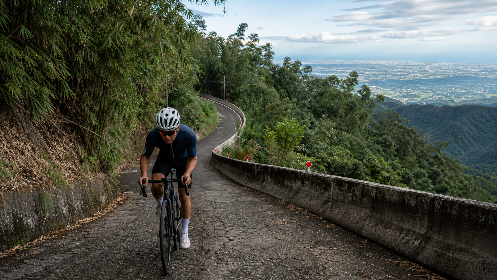
Zhushan Guanhaiping is a hard-core climb in the Da’an area of Zhushan Township, Nantou. The section covered in this article is approximately 11.6 km long with about 1,015 meters of elevation gain and an average gradient of 6.1%, rated Category 4 on Strava. The route it sits on, County Road 49 (Da’an Forest Road), has a spine-chilling nickname in the cycling community—the “Demon Country Road.” The full Route 49 starts at an elevation of just about 169 meters but ends at roughly 1,710 meters, a vertical drop of over 1,500 meters, including a continuous steep climb of more than 10 km averaging nearly 10%.
The 6.1% average gradient is the result of averaging out the steep and gentle sections of the Guanhaiping stretch—don’t be fooled by it. The true face of Route 49 is a remote mountain grind with “narrow roads, steep grades, and aging pavement,” and its difficulty is often compared to the Neihu–Wuliao section of Provincial Highway 136. This article takes an engineer’s perspective to break down this “Demon” and tell you how to survive the climb to Guanhaiping.
Route Overview: Know the True Face of the “Demon”
| Item | Data |
|---|---|
| Distance of this section | Approx. 11.6 km |
| Elevation gain of this section | Approx. 1,015 m |
| Average gradient | 6.1% |
| Strava rating | Category 4 |
| Route 49 full-line starting elevation | Approx. 169 m |
| Route 49 full-line ending elevation | Approx. 1,710 m |
The full Route 49 is about 26.8 km long (after being merged with Route 49-1 in 2016, the start moved back to Dazhi Road intersection, making it about 29.6 km), with a vertical drop of roughly 1,541 meters. The most brutal part is the latter half from around the 19.7k mark to the end: the road is only about 2 meters wide with poorly maintained pavement (rigid surface/old asphalt)—this is exactly where the “Demon” nickname comes from. Guanhaiping (the focus of this article) sits roughly in the middle of Route 49 and is the signature viewpoint with the widest panorama on this punishing climb.
Why 6.1% Is a Gentle Lie: Interpreting the Gradient Distribution
The “6.1% average gradient” attached to the Guanhaiping section is a thoroughly misleading number. It takes the relatively manageable gentle climb of the early section and the nearly 10% continuous long steep section later, “weight-averages” them into a fictional uniform slope, and smooths out the gradient spikes that actually kill you. From an engineering standpoint, judging how hard a climb is requires more than just the average gradient—you also need to look at “gradient variability” and the “length of the steepest continuous segment.”
This is where Route 49’s cruelty lies: laying out the full Route 49, climbing from about 169 meters at the start to about 1,710 meters at the end, a vertical drop of about 1,541 meters, the latter half from around the 19.7k mark to the finish has a road width of only about 2 meters, aging pavement, and includes a continuous steep climb of more than 10 km averaging nearly 10%. In other words, the elevation gain on this road is not evenly distributed—it compresses most of the suffering into that long string of near-10% grades in the latter half. This structure of “getting harder the further you go” is exactly why it’s called the “Demon Country Road” and why its difficulty is often compared to the Neihu–Wuliao section of Provincial Highway 136.
| Section Character | Approximate Gradient Band | Road Condition | Tactical Role |
|---|---|---|---|
| Early warm-up gentle climb | Approx. 5–7% | Acceptable | Save energy, confirm gear ratios |
| Middle section around Guanhaiping | Medium-high, rolling | Deteriorating | Cruise + scenic refueling |
| Latter continuous steep climb | Near 10% (sustained) | Road narrow at ~2 m, aging pavement | Grind the lowest gear, a battle of will |
Power and Heart Rate Zone Reference Table
Facing a continuous long steep climb of nearly 10%, managing your pace with power/heart rate zones is key to avoiding having to put a foot down midway. The framework below uses percentages of FTP and maximum heart rate (adjust based on your own testing):
| Zone | %FTP | %Max HR | How to Use It on This Road |
|---|---|---|---|
| Z2 Endurance | 56–75% | 70–80% | Early warm-up gentle climb |
| Z3 Tempo | 76–90% | 80–87% | Middle section cruise to Guanhaiping |
| Z4 Threshold | 91–105% | 88–92% | Forced into on the steep points of the latter section |
| Z5 and above | >105% | >92% | Barely used; if you hit it, you’re blown |
The special thing about Route 49 is this: the near-10% long steep climb in the latter half will force your heart rate up, even if you’re already in your easiest gear. So discipline in the early section is especially critical—any Z4 overspending up front will be repaid with interest later. The core philosophy is “hold Z2 in the early section, keep it in Z3 in the middle, and save all your Z4 allowance for the continuous steep climb in the latter half.”
Gear Ratio Reference Table: This Is a Road Where Insufficient Gears Means Dismounting
The near-10% continuous climb in the latter half of Route 49 is the ultimate test of gear ratios. Below is a reference for the rear cog needed to maintain 60 rpm on the steep points of the latter section (estimated at ~10% gradient, speed ~7–9 km/h):
| Chainring | Rear cog needed to maintain 60 rpm | Verdict |
|---|---|---|
| 50/34 standard compact | Needs 34T or larger, still a struggle | Not recommended to force it |
| 48/32 sub-compact | 34T and up is more manageable | Minimum threshold for average enthusiasts |
| 46/30 or wider gravel gearing | 36–40T all comfortable | For heavier riders / the safe choice |
Remember this road’s iron rule: if your largest cog is only 28T or 30T, swap in a 34T before you come, or the near-10% continuous climb in the latter half will force you off the bike. This isn’t something grit can solve—it’s a physics problem of gear ratio versus gradient. If the gears aren’t there, no amount of willpower can turn the pedals.
Section Strategy 1: The Warm-Up Gentle Climb
The early part of the climb toward Guanhaiping is relatively manageable. This is where you confirm your gear ratios and settle your heart rate into the climbing cruise zone. Because the latter half of Route 49 is extremely hard, discipline in the early section is especially important—any premature overspending will be paid back double later.
- Gearing: Middle chainring with a large rear cog, spinning easily at 75–80 rpm.
- Heart rate: Keep it at 73–76% of max HR, steady and unhurried, saving your strength.
- Reminder: Check your supplies, water bottles, and brake feel, because the higher you go, the worse the road gets and the less room you have to adjust.
Section Strategy 2: The Continuous Steep Climb (Core Hard Section)
Entering the continuous steep climb of Route 49, the gradient will frequently push past 8–10%. This is the most demanding part of the entire route for both gearing and willpower, and where the most people dismount.
- Gearing: Stay firmly on the largest rear cog, keeping your cadence at 60–65 rpm. If you can’t turn the pedals, prefer a zigzag line (only when safe and free of oncoming traffic) rather than forcing a straight line.
- Pedaling rhythm: Primarily seated grinding in a low gear; only stand and stomp for two or three strokes on the steepest short pitches, then sit back down immediately. Standing and grinding the entire way on a near-10% long climb is suicide.
- Pavement awareness: The latter section is only about 2 meters wide with aging pavement—watch for potholes, loose gravel, and the vibration from the rigid surface. Be conservative through corners and when passing.
Section Strategy 3: The Guanhaiping Viewpoint
Reaching Guanhaiping is the visual reward for this climb. On clear days, you can look down over Zhushan Township, the Zhuoshui River, the Qingshui River, and the Bagua Mountain Range, and with good visibility you can even see as far as the Changhua and Yunlin plains and even the Taiwan Strait. Once you arrive, be sure to refuel and rehydrate, and note that it’s cool in the deep mountains—add a layer for warmth when resting.
(The exact kilometer marker for Guanhaiping varies slightly between sources; in practice it falls in the middle section of Route 49, so follow the signs on site.)
Steep Climb Technique: Zigzagging and When to Stand and Sprint
On the sustained ~10% grades in the latter section, charging straight up with brute force is the fastest way to burn out. Technique-wise:
- Proper use of zigzagging: Only when you’ve confirmed it’s safe, visibility is good, and there’s no oncoming traffic, use a zigzag pattern on wider sections of road, trading increased distance for a reduced effective gradient. However, the road width on the latter part of Route 49 is only about 2 meters, leaving very limited space for zigzagging. Safety must be the top priority—dismount rather than risk crossing into the oncoming lane.
- Stay seated and grind as the main approach: On a long ~10% climb, standing and sprinting the entire way is suicide—it consumes high amounts of oxygen and spikes your heart rate rapidly. You should primarily stay seated, use a low gear, and grind, keeping your weight stable and maintaining forward momentum through cadence.
- Stand and sprint only at critical points: Only stand and power for two or three pedal strokes when you hit a sudden steeper short pitch to get over it, then immediately sit back down and recover once past the critical point. Standing and sprinting is a “rescue tool,” not your “primary pedaling style.”
Cornering and Braking on Old Pavement
The latter section of Route 49 has old pavement and narrow roads; the rigid surface and loose gravel make handling significantly more difficult:
- Prevent stalling when cornering uphill: At low speeds, you’re most likely to stall and fall at the apex of a corner. Preserve a bit of momentum to roll through the steepest point of the apex—it’s far less taxing than restarting after stalling.
- Be conservative when passing vehicles: The road is about 2 meters wide. When encountering uphill vehicles (construction trucks, delivery vans), slow down well in advance and pull over to yield. Don’t force a pass on a steep slope.
- Gravel and potholes: Old pavement often has potholes and scattered gravel. Look far ahead to read the road surface early, preventing your front wheel from being pulled off course by gravel.
Gear Ratio and Equipment Recommendations
Facing sustained long steep climbs approaching 10%, your gear ratio is the line between life and death:
| Equipment Item | Recommendation |
|---|---|
| Chainring | Sub-compact 48/32 or lighter; strongly advised to go as light as possible |
| Rear Cassette | Start with a max gear of 34T; consider a wider range if you’re heavier |
| Tires | 28c or wider, to handle old pavement and gravel |
| Brakes | Disc brakes are preferable; crucial for heat dissipation and control on long steep descents |
| Warmth | Windbreaker is a must; deep mountain cold plus wind chill on descents |
| Nutrition | Bring at least two bottles of water; resupply points are scarce in the deep mountains |
This is a road where “insufficient gearing means you’ll be walking.” If your largest gear is only 28T or 30T, it’s strongly recommended to swap to a 34T before challenging Route 49; otherwise, on the sustained ~10% grades in the latter section, the gradient will force you off your bike.
Resupply, Hydration, and Seasons
Resupply points are extremely scarce in the deep mountain section of Route 49. Make sure to stock up on water and food before heading up. Nearby attractions and resupply are mainly in Zhushan (sweet potato buns, bamboo shoot dishes, Zhushan Old Street); choose specific shops on-site.
Seasonally, the deep mountains are cool, with fog and afternoon thunderstorms common. Summer offers heat relief but has strong afternoon convection and higher rockfall risk; winter is damp and cold, requiring strict prevention of hypothermia. Old pavement becomes even more slippery after rain—be sure to start early and complete the climb and descent while it’s dry.
High-Altitude Physiological Effects and Countermeasures
The summit of Route 49 is at approximately 1,710 meters, and the Guanhaiping area is already at considerable elevation. As altitude increases, the partial pressure of oxygen in the air decreases, reducing your VO2 max and sustainable power output; at the same power, your heart rate will be higher than at sea level, and perceived exertion will be more pronounced. This is amplified on the “already ~10%” steep grades of Route 49’s latter section—you’ll feel more breathless and find it harder to maintain cadence than on similar gradients at lower elevations.
There are three countermeasures: First, at high altitude, “accept lower power and protect your heart rate.” Don’t force more pressure just because your power numbers drop—that will only cause you to blow up early. Second, the air at high elevations is dry and cold, and rapid breathing accelerates fluid loss; hydrate more frequently than you would at sea level. Third, if you rarely ride at altitude, mild dizziness and rapid breathing upon reaching higher elevations are normal—slow down, take deep breaths to adjust, and never push through it.
Weather Risk Classification
Weather on a hard deep-mountain climb directly affects safety, especially since the old pavement on Route 49’s latter section is more dangerous after rain:
| Risk Level | Weather Signs | Recommended Action |
|---|---|---|
| Green (Rideable) | Clear morning, good visibility, dry road | Start as normal, still bring warm layers |
| Yellow (Caution) | Afternoon cloud buildup, light mountain fog | Pick up the pace, complete the descent while it’s dry |
| Orange (Shorten) | Dense fog, poor visibility, light rain, wet pavement | Shorten the route or turn back early |
| Red (Abort) | Thunder, significant rain, strong winds, signs of rockfall | Stop immediately; lightning and rockfall in the deep mountains are not to be taken lightly |
Summer afternoons in central Taiwan’s deep mountains bring intense convection and elevated rockfall risk; winter is damp and cold, requiring hypothermia prevention; old pavement becomes more slippery after rain. This is also why “you must start early”—schedule the hardest climb and the most dangerous long descent before the afternoon weather changes.
Resupply Schedule (Even More Critical When Deep-Mountain Resupply Is Scarce)
Resupply points are extremely scarce on Route 49’s deep mountain section, so your nutrition strategy must be “time-driven” rather than “feeling-driven,” and you should carry enough before heading up:
| Time Point | Hydrate | Energy | Notes |
|---|---|---|---|
| Before departure | Drink a few sips first | — | Almost no resupply points on the mountain; fill up beforehand |
| Every 15 minutes | Small sips of water | — | Deep mountain dry and cold, hydrate even more frequently |
| Every 30–45 minutes | — | One serving of energy (gel/bar/rice ball) | Don’t wait until you’re empty to eat |
| Before the final steep climb | One water refill | One serving of fast sugar | Pre-fuel for the hardest section |
| During heavy sweating | — | Salt tablets/electrolytes | Prolonged grinding on steep slopes can cause cramps |
Training Advice: How to Prepare to Conquer the Big Demon
Route 49 is a hard, long steep climb; challenging it recklessly easily leads to a DNF. It’s recommended to arrange targeted training several weeks before the attempt:
- Climbing-specific endurance: Find a sustained steep climb with a similar gradient and repeat it, simulating the muscle recruitment of “low-cadence seated grinding” and adapting to prolonged high heart rate.
- Threshold intervals: Do one weekly session of Zone 4 intervals (e.g., 4×8 minutes) to raise your FTP, making the ~10% grades in the latter section relatively more manageable.
- Low-cadence strength riding: Deliberately use a slightly heavier gear and low cadence (50–60 rpm) for strength segments to build the leg power needed for steep climbing.
- Simulated long steep ride: Before the challenge, do one simulation ride with “similar total elevation gain and sustained steep sections” to verify your gearing and pacing—don’t leave your first test for the actual challenge day.
Descending Technique: Long Steep Descents Are More Dangerous Than Climbs
Route 49 has over 1,500 meters of elevation difference, and the return is a long, steep descent with poor pavement—riskier than the climb itself:
- Brake heat dissipation: On long steep descents, avoid dragging the brakes continuously. Use “pulsing” intermittent braking to let the discs cool, preventing brake fade (disc brakes are clearly superior to rim brakes here).
- Slow down on old pavement: The latter section is narrow at about 2 meters with many potholes and gravel; slow down significantly and look far ahead to read the road surface.
- Brake before corners, accelerate out: Complete your braking on the straights, carry a controlled speed through the corner, and avoid hard braking mid-corner.
- Stay warm to prevent hypothermia: Descending long distances from high altitude creates strong wind chill; put on your windbreaker before starting to avoid hypothermia-induced sluggishness.
Common Mechanical Issues and Pre-Ride Checks
The worst thing on a hard deep-mountain climb is a breakdown mid-ride, and cell reception on Route 49 may be unreliable with difficult rescue access. Pre-ride checks and carrying tools are your last line of defense:
| Item | Check Focus | Tools to Carry |
|---|---|---|
| Drivetrain | Smooth shifting, no chain skip (most prone to issues under low-speed heavy load) | Multi-tool, quick link |
| Brakes | Pad thickness, hydraulic feel (critical for long steep descents) | — |
| Tires/Tubeless Repair | Tire pressure, no cuts on tread (prevent gravel punctures) | Spare tube/patch kit, pump or CO2 |
| Chain | Lubricated, no rust or stiffness | Quick link, chain tool |
| Bolts | Seatpost, handlebar, pedals secure | Torque/hex tools |
The two most common mechanical issues on Route 49 are “chain drop during low-speed shifting on steep grades” and “brake overheating on long steep descents”—the former is prevented by shifting early and regular maintenance, the latter by pulsing braking and disc brakes.
Common Mistakes and DNF Risks
- Insufficient gearing: If your largest gear isn’t big enough, the near-10% steep sections in the latter half will force you off the bike—this is the most typical cause of DNF on Route 49.
- Starting too fast: Burning your energy in the warm-up section leads to a collapse when you hit the hard section.
- Losing control on the road surface: The latter half has narrow roads and poor pavement; reckless descending or cornering errors can cause danger.
- Insufficient supplies and warmth: Deep in the mountains, supplies are scarce and temperatures are low; dehydration or hypothermia can end your ride.
Target Times for Riders of Different Levels (Reference for the 11.6 km Core Section)
| Rider Level | Gearing Strategy | Reference Completion Time |
|---|---|---|
| Finish the Challenge | Grind in the lowest gear throughout, rest in segments | 100+ minutes |
| General Fitness | Steady heart-rate cruising, stand to climb on steep pitches | 70–85 minutes |
| Advanced Enthusiast | Steady power cruising, cautious on the road surface | 55–65 minutes |
| Intensity-Focused | Push threshold power throughout | 45–55 minutes |
Safety Reminders
Route 49 is a hard climb deep in the mountains—narrow roads, poor pavement, few supply points, and mobile reception may be unreliable. Strongly recommended: ride with companions, inform family and friends of your itinerary, carry repair tools and a spare tube, and confirm your brakes and gearing are in good condition. This is not a road for showing off. Ride within your limits and be well prepared—that is the least respect you can show the “Big Demon.”
Debunking Common Myths
Regarding Route 49, the “Big Demon Township Road,” there are plenty of plausible-sounding claims floating around online. Let’s debunk a few common myths before you head out, so you don’t prepare the wrong way due to misunderstandings:
- Myth 1: “An average gradient of 6.1% isn’t that extreme, it should be manageable.” This is exactly the trap flagged at the start of this article—the average gradient is a weighted average of the gentler early climbs and the near-10% long steep sections in the latter half. The actual suffering you feel on the bike is far heavier than the number 6.1% suggests. Never estimate difficulty from the average gradient; look at the length and gradient of the steepest continuous sections.
- Myth 2: “A 50/34 compact crank can handle any road, this one included.” On the near-10% continuous climbs in the latter half, even with the largest 34T ring, it’s very hard to keep cadence above 60 rpm. For most amateur riders, it’s still quite demanding. This is one of the few routes where seriously evaluating a sub-compact or even wider gear range is recommended.
- Myth 3: “It’s just a township road, so the conditions should be similar to a typical farm access road.” The latter half of Route 49 is only about 2 meters wide with aging pavement. Rigid surfaces, gravel, and potholes are noticeably more common than on your usual training routes. You need to be more conservative with handling and braking—don’t judge it by the standard of the farm roads you normally ride.
- Myth 4: “I’m riding during the day and the weather looks fine, so I shouldn’t worry too much.” Deep mountain terrain is prone to rapid fog and rain in the afternoon, especially on the latter-half steep climbs where the pavement is already old and slippery. The weather can change in an instant. This is why this article repeatedly stresses “starting early”—finish the hardest climbs and the most dangerous descents before the afternoon weather turns.
PR Challenges and Segment Pacing Advice for Advanced Riders
If you’ve already finished the route once or twice and want to push for a personal record (PR), there are several tactical details worth noting on the Guanhaiping section of Route 49:
- Setting segment goals: Instead of staring at the total time, break the 11.6 km into three parts—the warm-up section at the start, the Guanhaiping section in the middle, and the continuous steep climb at the end—and set a target pace for each. Cruise the first section at a steady heart rate or power, allow minor fluctuations in the middle for sightseeing and refueling, and save all your real explosive power for the final section.
- Pacing control on the steep pitches in the latter half: A common mistake among advanced challengers is going out too hard at the start of the near-10% long climbs, causing heart rate to spike and cadence to drop below 40 rpm in the final 2–3 km. We recommend subdividing the latter half into three smaller segments, each with a fixed upper heart-rate limit. Better to be conservative early and still have something left to close out the finish.
- The importance of warming up: The climb on Route 49 has almost no flat buffer zone to let your body gradually ease into the effort. Before the start, spend 10–15 minutes warming up on flat ground, bringing your heart rate to the mid-Z2 range before beginning the ascent. This can effectively prevent going anaerobic too early because your body hasn’t warmed up yet.
- Marginal gains from equipment: On near-10% long climbs, every kilogram of bike weight saved yields noticeably more time benefit than on gentler slopes. If you’re an advanced rider targeting a PR, re-examining whether you can trim the number of water bottles or the weight of your tools will show results faster than adding another interval session.
- Strava segment notes: The start and end points of Strava segments along Route 49 may vary slightly depending on who recorded them. When challenging your personal record, be sure to use the same segment you’ve completed in the past as your baseline, rather than directly comparing records from different segment boundaries—only then will it truly reflect your improvement.
- Consistency of weather conditions: Results on this road are heavily affected by wind direction, temperature, and whether the pavement is wet or dry. With the same fitness level, you could be several minutes slower on wet pavement or a headwind day. We recommend attempting a PR in the early morning when it’s dry, calm, or with a tailwind, and recording the day’s weather conditions so you can factor out weather variables in future comparisons and more accurately assess your true progress.
Mental Preparation for First-Time Challengers
Compared to equipment and gearing, many people underestimate the psychological test Route 49 presents. On the continuous near-10% long climbs in the latter half, what wears you down most is often not the muscles but the mental pressure of “not seeing the end”—corner after corner, yet the gradient never seems to let up. We suggest first-time challengers shift their focus from “how many kilometers are left” to “is my cadence steady this minute,” replacing anxiety about total distance with short-cycle mini-goals. This will get you through the most painful sections far better than staring at the mileage. Also, be mentally prepared: getting off and walking your bike midway is nothing to be ashamed of. Route 49 is famous for its difficulty precisely because it demands respect. Riding within your limits and keeping a safety margin is always more important than stubbornly grinding to the finish.
Route 49 won’t become gentler just because you did one more interval session, but it will honestly repay every bit of preparation—get the gearing right, hold your pace, keep your mind steady, and this “Big Demon” will give you a worthy payoff with the view from Guanhaiping.
Conclusion
Zhushan Guanhaiping and the Route 49 “Big Demon Township Road” it sits on are the touchstone of Nantou’s climbing scene. It doesn’t rely on flashy event packaging; it earns its reputation through honest and brutal gradients, narrow aging pavement, and the near-10% continuous climbs in the latter half. But when you drag yourself up to Guanhaiping in exhaustion and see the Zhushan Basin, the Zhuoshui River, and the Bagua Mountain Range spread out below—even catching a glimpse of the sea in the distance—you’ll understand the meaning of the name: on a ridgeline deep in the mountains, gazing at a sea. Shift into your easiest gear, carry respect in your heart, and this “Big Demon” will reward the truly prepared rider with an entire panorama of grandeur.
Related Reading
- Guanhaiping: If the Mountain Is High Enough, You Can See the Sea—Route 49’s Bagua Tea Gardens and Bamboo Sea
- Zhushan Shanlinxi Twelve Zodiac Bend Guide: Pacing Discipline for a 26.9 km Long Climb
- Lugu Route 101 Guide: A 4.3% Entry-Level Training Route, Gateway to the Dalunshan Scenic Area
- Route 56 Shenmu Climb Practical Guide: 6.9 km with 653 m of Elevation Gain, Data Analysis of Nantou’s Secret Hard Steep Climb
台北闊瀨陡坡 騎旅 / 日本單車雜誌編輯車友臨時加入!/ 髮香才是最強的 / feat. 北迴歸線小隊 / 公路車 CT Yeh
6 個月前
大武山20%魔王陡坡【JJSC南台灣遊騎Day2】!屁股真的要裂開了...凡士林抹滿也沒用?神秘金教堂還有超便宜夜市
3 個月前
半日 小台灣 極限單車路線挑戰實錄
7 年前
大武山後門26%歡樂陡坡!JJSC南台灣單車行Day2 / 被颱風追著跑 / 公路車 / CT Yeh
2 年前
萬年峽谷! 30% 超激陡坡 里佳部落DAY2 還是很硬! | 公路車 | CT Yeh
3 年前
新竹羅平 x 天湖部落 大禹嶺級變態陡坡! 4K超高畫質 空拍 | 公路車
5 年前
觀霧 變好騎了! | 北高車友爆笑大會師 | 公路車 | 單車旅遊 Taiwan Cycling Route GuanWu
6 年前
4K單車實境) 舊陽金P字道 第1P 仰德大道至小油坑 誤跟武嶺神人們 被拉爆爽飛天 Taiwan Cycling Climb Route Recommend
7 年前