Mount Ishizuchi Skyline Guide: Conquering the 12 km Sky-High Climb to Tsuchigoya, Gateway to Western Japan's Highest Peak
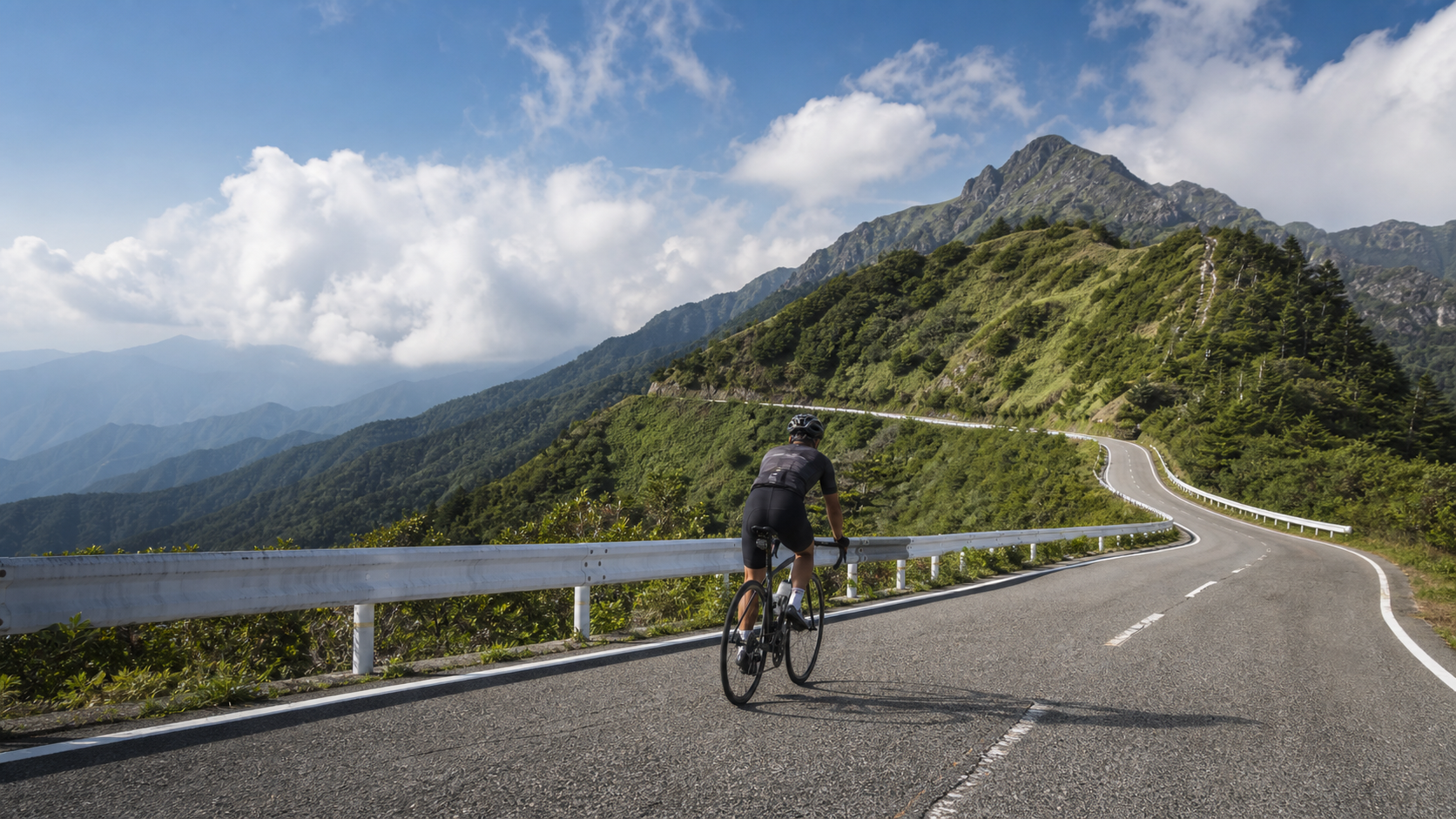
On the roof of Shikoku lies a sky road to the highest peak in western Japan—the Mount Ishizuchi Skyline. It is a renowned Shikoku route cherished by hikers, photographers, and cyclists alike, carrying you all the way up to Togochi, the trailhead of Mount Ishizuchi.
Let’s first clarify the geography, because this road is often confused with another. The official name of the Mount Ishizuchi Skyline is Ehime Prefectural Route 12 “Saijo-Kuman Line,” located in Ehime Prefecture (not Kochi Prefecture). It ascends from the Omogo direction to “Togochi,” one of the trailheads of Mount Ishizuchi. The Togochi parking area sits at an elevation of approximately 1,492 meters, with a national lodging facility, free parking, and a cafeteria. Mount Ishizuchi itself stands at 1,982 meters, making it the highest peak in western Japan. The road has been free to use since September 1, 1995 (it was originally a toll road).
For Taiwanese cyclists, the name Mount Ishizuchi may not ring as loudly as Mount Fuji, but its status in western Japan is monumental—it is the region’s highest peak, the heart of Shikoku’s roof, and a sacred site of a thousand years of mountain worship. The Mount Ishizuchi Skyline leading to it is one of Shikoku’s most iconic scenic roads. Together with the adjacent UFO Line, it forms the signature “Shikoku Roof Sky Journey” route in the minds of Japanese cyclists. If you’re planning a cycling trip through Shikoku, this sky climb to the gateway of western Japan’s highest peak is absolutely worth adding to your list.
About the data: the reference figures for the climb segment cited in this article are approximately 12.19 km in distance with an average gradient of 5.8% (these are Strava segment measurements; since Strava shows the elevation gain as 0, the estimated gain of around 700 meters is calculated by multiplying gradient by distance). The full course of the official “Ishizuchi Hill Climb” event, on the other hand, runs from Omogo Furusato no Eki (elevation 572 meters) to Togochi (elevation 1,492 meters), covering 22.1 km with an elevation difference of 920 meters and an average gradient of 6.0% over the climbing section. The two sets of numbers don’t conflict—the Strava segment is part of the Skyline itself, while the event course includes the approach road in the earlier section.
“A Steady Long Climb” Defines This Road
Before breaking down the route, let’s establish a core understanding: the character of the Mount Ishizuchi Skyline is that of a “steady long climb,” not a “brutal steep ascent.” Its average gradient falls between 5.8% and 6.0%, with no sudden wall that instantly breaks you. Instead, it offers stretch after stretch of stable, predictable climbing.
This character dictates how you should ride it. Facing a steady long climb, the most effective strategy isn’t “muscling through the steep bits with explosive power” but rather “evenly consuming the entire road at a consistent tempo.” You want to move like a machine at a uniform speed, keeping your heart rate and power in a zone you can sustain for a long time, completing the climb with patience rather than brute force. This also means the road demands more “pacing discipline” than “absolute strength”—it rewards riders who know how to manage their rhythm, not those who simply charge ahead. Understand this, and you’ve grasped the essence of the Mount Ishizuchi Skyline.
1. Route Overview and Real Data
| Item | Strava Segment | Official Event Course |
|---|---|---|
| Distance | Approx. 12.19 km | 22.1 km |
| Elevation Gain | Approx. 700 m (estimated) | 920 m |
| Average Gradient | 5.8% | 6.0% |
| Finish | Togochi (approx. 1,492 m) | Same as left |
| Location | Ehime Prefecture | Same as left |
| Difficulty Rating | Intermediate to intermediate-advanced long climb | Same as left |
2. Important Geographic Clarification: Mount Ishizuchi Skyline ≠ UFO Line
This is the most commonly confused point. On Strava, the start is sometimes marked in Ino Town, Kochi Prefecture, for the following reason: the terminus of the Mount Ishizuchi Skyline, Togochi, happens to connect with another famous ridge road, the “UFO Line (Kamegamori Forest Road).” The UFO Line’s official name is “Town Road Kamegamori Line / Kamegamori West Line,” stretching about 27 km along a ridge at elevations of 1,300–1,700 meters, and it falls under the jurisdiction of Ino Town, Kochi Prefecture—this is exactly why Strava marks the location as “Kochi Prefecture / Ino Town.”
In other words: the Mount Ishizuchi Skyline itself is in Ehime Prefecture, while the ridge scenic road continuing toward Kochi from its terminus is a separate road, the UFO Line. The two roads meet at Togochi. When planning, keep them distinct and don’t conflate the two. By the way, the name UFO Line actually derives from a pun on “Yūhō” (the majestic peak), and has nothing to do with aliens.
Another point of confusion worth clarifying: Mount Ishizuchi’s cable car (Ishizuchi Tozan Ropeway) is on the Seijo side via the Jōseisha route—the cable car runs from Shimotani Station at the foot (elevation 455 meters) to Jōseki Station at the summit (elevation 1,300 meters), spanning 1,814 meters in about seven and a half minutes, with panoramic views of Mount Kamegamori from the windows. However, this cable car trailhead is not the same trailhead as Togochi, where the Skyline ends; it’s a different climbing route up Mount Ishizuchi. When writing or planning, don’t confuse the “Jōseisha trailhead with the cable car” with the “Togochi trailhead reached by bike” as if they were the same path. Mount Ishizuchi has multiple climbing routes, and Togochi is just one of them—keeping this in mind will help you plan your itinerary correctly.
3. Section-by-Section Guide
Section 1: Starting from the Omogo Side (Warm-Up and Priming)
Starting from the Omogo direction, this section winds through the lush forests of the Shikoku mountains, with gradients mostly falling in the steady 5–6% range. The keyword here is “stability.” This road’s character is that of a “steady long climb” rather than a “brutal steep ascent,” so your task is to establish a rhythm you can sustain for a long time, keeping your heart rate in the aerobic zone, moving like a machine at a uniform speed. While this even gradient won’t deliver sudden shocks, the cumulative effect of 12 continuous kilometers of climbing remains a solid challenge that demands patience and discipline.
Omogo Valley (Omogokei) lies right near the entrance to the Skyline—it’s the headwaters of the Niyodo River, whose water quality has been ranked number one in Japan, with its clear streams known as “Omogo Blue.” If you have time before starting the climb, it’s worth a look.
The pacing philosophy for this opening section is “be a little boring.” You must deliberately suppress the urge to test your legs or chase the rider ahead, using a fixed cadence and fixed heart rate to “transport” yourself up the mountain. The reward of a steady long climb comes later, in the views and at Togochi; any moment of overexertion in the early going will come back to you as doubled fatigue in the later stages. Treat these 3 to 4 kilometers as a long warm-up, letting your body gradually settle into a stable aerobic state.
Section 2: Winding Along the Mountainside (Main Middle Climb)
This section is the primary climbing block of the entire route. The gradient remains moderate at 5–6%, and the road winds upward along the mountainside with numerous switchbacks. As elevation gradually rises, the views open up more and more. Pacing strategy: maintain a steady cadence (75–85 rpm), accumulating elevation at a consistent rhythm, and avoid surging or easing off in the middle. This kind of steady long climb is best ridden with a “fixed power” or “fixed heart rate” approach, distributing your effort evenly across the entire road.
The forests of the Shikoku mountains keep changing their appearance through this section. As altitude increases, you’ll pass through different layers of vegetation, occasionally catching glimpses of distant ridgelines and valleys around the bends. This rhythm of “climbing while taking in the scenery” is precisely the charm of the Mount Ishizuchi Skyline—it doesn’t force your head down with steep pitches but gives you the leeway to look up and appreciate the grandeur of Shikoku’s roof. The winding road also keeps the climb from becoming monotonous, as every turn may reveal a new vista.
Along the way, the Nagao Ridge Lookout is a viewpoint worth stopping at, offering views of Mount Ishizuchi and the “Goraikō Waterfall.” Stopping mid-way through a steady long climb to rest your eyes, catch your breath, and then continue with renewed energy is the right way to approach this kind of scenic ascent. Don’t turn it into a head-down ordeal; taking time to stop, look, and photograph will enrich the entire ride. After all, one of the greatest values of the Mount Ishizuchi Skyline is its scenery—if you’re so focused on the road ahead that you miss the breathtaking views along the way, that would be a true shame.
Section 3: Climbing to Tsuchigoya (The Final Stretch)
The final climb to Tsuchigoya sits at an elevation of approximately 1,492 meters. This is one of the trailheads for Mount Ishizuchi, featuring a cafeteria and lodging facilities, and it also marks the terminus of the Skyline road. On clear days, this spot offers an excellent vantage point for viewing the majestic form of Mount Ishizuchi and the distant ridgelines. From here, you can also continue toward the UFO Line and take in the ridge-top scenery of that “Sky Road” (though that is a journey for another day).
The moment you arrive at Tsuchigoya, you’ll find yourself in a rather unique scene: hikers carrying climbing packs, preparing to summit Mount Ishizuchi, and you, a cyclist who rode up on two wheels, meeting at the same elevation. Everyone is here for the same goal—the highest peak in western Japan—just approaching it in different ways. This atmosphere of “different paths, same destination” is a charm unique to Tsuchigoya, and it adds a meaningful layer of connection with mountain culture to your climb.
4. Gearing and Equipment
The gradients on the Ishizuchi Skyline are consistent and not overly severe, making gear requirements more forgiving than on routes with brutal ramps:
- Chainrings: A compact 50/34 is sufficient for these steady, moderate gradients.
- Cassette: An 11–32T will be adequate for most riders; if you prefer a more relaxed pace to enjoy the scenery or are being conservative with your energy, an 11–34T will make the entire long climb feel more comfortable.
- Cadence: Maintaining a steady cadence of 75–85 rpm throughout is the most efficient way to tackle this kind of uniform, long climb. Grinding a big gear at low cadence will only fatigue your muscles sooner—a major mistake on a long ascent.
In terms of gear, while the summit elevation isn’t as high as Mount Fuji, the altitude of nearly 1,500 meters will still feel noticeably cooler than down at the base, and combined with wind chill on the descent, it’s advisable to carry a lightweight windbreaker and full-finger gloves. The mountain weather in Shikoku is changeable, so also be mindful of possible afternoon weather shifts.
A common misconception is that “since the summit is only 1,500 meters, you don’t need much warm clothing.” But don’t forget—while you’re stopped at Tsuchigoya taking photos and resting, your body will cool down, and then you face a long descent. During the descent, you’re not generating much heat and are directly exposed to cold wind, making the perceived temperature much lower than during the climb. Add to that the unpredictable mountain weather in Shikoku—a sudden afternoon shower can send temperatures plummeting in an instant. So, it’s better to carry a thin jacket and not need it than to regret not bringing one on a cold, wet descent. Full-finger gloves ensure your fingers remain agile and your braking feel is good on the descent—an important safety detail on long mountain downhills.
5. Supplies and Hydration
This route has moderate distance and consistent gradients, so the pressure on supplies isn’t as intense as on super climbs, but you still need to pay attention:
- Before departure: Eat enough carbohydrates.
- On the bike: Carry at least one to two bottles of water and some food supplies.
- Tsuchigoya: Has a cafeteria that can serve as a supply and rest point at the finish, but don’t rely entirely on it (operating hours and seasons can vary); bringing your own sufficient supplies is the safest approach.
- The Omi area before the climb starts is your last chance for supplies at the base. Supply points are scarce once you’re on the mountain, so be sure to fill your bottles and stock up here.
The supply rhythm for this road can be summarized as “stock up at the base, conserve on the way, replenish at Tsuchigoya.” Since there are almost no supply points after you start climbing, you must bring everything you need before you set off. During the climb, eat and drink regularly in small amounts to avoid major swings in blood sugar. After reaching Tsuchigoya, use the local cafeteria to replenish. This rhythm ensures you maintain a steady energy supply throughout the entire climb and descent, preventing you from falling into a low-blood-sugar or dehydrated predicament halfway.
6. Access Hours and Seasonal Restrictions (Extremely Important)
The Ishizuchi Skyline has strict access regulations, an aspect you absolutely cannot overlook when planning:
- Fully closed in winter: Closed from December 1 to March 31 each year, reopening at 7:00 AM on April 1.
- Nighttime passage prohibited year-round: Access hours vary by season (based on sunrise/sunset), for example:
- 4/1–4/28: 07:00–18:00
- 6/1–6/30: 07:00–20:00
- 7/11–8/31: 07:00–20:00
- 9/1–11/30: 07:00–18:00
(The above hours are examples; please refer to the latest official announcements for actual access times during each period.)
This means: You can only complete both the ascent and descent between April and November, and within the daytime access hours. Be sure to check the access hours for your specific day in advance, allow ample time, and don’t get caught outside the gate closure times.
This strict access regulation is what most distinguishes the Ishizuchi Skyline from most freely accessible climbing routes. It requires you to incorporate “time management” into the core of your trip planning. The recommended approach: schedule the climb for the morning, departing shortly after the access hours begin. This gives you ample time to complete the ascent, rest and take photos at Tsuchigoya, and then descend at a relaxed pace, without any worry of hitting the gate closure. Conversely, if you start too late or linger too long on the mountain, you may face the pressure of “having to descend before the gate closes,” or even get stuck outside the access hours. Knowing the access hours and managing your time well is the first step to completing this route safely and successfully—its importance is on par with your physical preparation.
Also, keep in mind that these seasonal and time restrictions reduce your “weather buffer.” If the weather turns in the afternoon, you may not have the option to delay or reroute. Therefore, pay close attention to the weather forecast, schedule your climb during stable weather windows, and always be prepared to adapt to changes.
7. Common Mistakes and DNF Risks
- Ignoring access hours: This is the most unique and easily overlooked risk for out-of-town riders on the Ishizuchi Skyline. Failing to check access hours or starting too late could leave you facing closed gates, unable to pass or descend.
- Inconsistent pacing: On a uniform long climb, the worst thing is to disrupt your rhythm. Speeding up and slowing down repeatedly pushes your body in and out of anaerobic effort, causing faster fatigue. Maintain a steady output.
- Insufficient warm clothing: With the altitude near 1,500 meters plus wind chill on the descent, you still need wind protection and warmth. Don’t underestimate it just because it’s hot at the base.
- Ignoring the weather: The Shikoku mountains are prone to afternoon weather changes; watch for visibility and rain. Combined with the access hour restrictions, the weather buffer is smaller, so be sure to check the forecast in advance.
Key Points for Preventing DNF
The difficulty of the Ishizuchi Skyline lies not in the gradient, but in the “regulations” and “logistics.” Therefore, the risk of a DNF (Did Not Finish) is usually not from being defeated by the climb itself, but from inadequate preparation. Here are some key prevention points:
- Time management: This is the most critical point. Check the access hours and gate closure times, depart in the morning, and allow plenty of buffer so you don’t get trapped by the gates.
- Weather assessment: The weather in the Shikoku mountains can change in an instant. Check the forecast before departure and schedule the climb during stable weather.
- Warm clothing preparation: With the summit near 1,500 meters plus wind chill on the descent, don’t neglect warmth just because “it’s hot at the base.”
- Supply planning: Supply points are scarce once you’re on the mountain; be sure to stock up on water and food at the base before you start climbing.
If you handle these things well, the Ishizuchi Skyline is actually a fairly “controllable” route—its consistent gradients won’t deliver any unexpected blows. As long as your logistics are in order, your chances of completing the ride are very high.
8. Target Times for Different Rider Levels
The following are reference times for the Strava climb segment (approximately 12.19 km):
| Rider Level | Reference Completion Time |
|---|---|
| Advanced Competitive | Approximately within 40 minutes |
| Steady Cruising | Approximately 50 minutes to 1 hour |
| Sightseeing Challenger | Approximately 1 hour 10 minutes or more (including stops for photos) |
Please treat these times as references only. This road offers beautiful scenery, and it’s well worth slowing down and stopping at several viewpoints to take it all in—there’s no need to chase speed relentlessly. For most people, the ideal ride is one where you can ascend at a relaxed pace within the access hours, properly appreciate the highest peak in western Japan at Tsuchigoya, and then descend safely.
9. Race: Mount Ishizuchi Hill Climb
This road is the stage for the official cycling race “Mount Ishizuchi Hill Climb,” organized by the local community. The course climbs from Omogo Furusato no Eki to Tsuchigoya (22.1 km, 920 m elevation gain), and is typically held in early September in recent years (for example, one edition was promoted for September 8). Note: The exact date changes every year—when planning, always refer to the latest official announcement and don’t lock in a date. If you want to challenge this road in the form of “racing,” following the official event information is the best approach.
Challenging the Ishizuchi Skyline through a race offers several unique advantages. First, the road is usually subject to traffic control or special arrangements during the event, allowing you to focus more on riding; second, the course starts a full climb from Omogo Furusato no Eki at 572 m elevation, making it the best way to experience the “full picture” of this road—more complete and more rewarding than a mere Strava climb segment; third, the atmosphere of tackling and crossing the finish line alongside many fellow riders is something hard to experience when riding solo. If your itinerary can align with the race date, treating “participating in the Mount Ishizuchi Hill Climb” as your way to challenge this road will be a truly memorable experience. Of course, the race quota, registration method, and exact date all need to be confirmed with the organizers in advance.
10. The Science of Pacing on a Sustained Climb
A sustained, steady climb like the Ishizuchi Skyline is best ridden with a “steady-effort” approach. Steady effort means maintaining a fixed power output or heart rate throughout the entire climb, rather than surging and easing. Why is this the most efficient? Because surging and easing repeatedly pushes your body in and out of anaerobic metabolism, accumulating lactate and causing faster fatigue; a stable output keeps your body in the most efficient aerobic zone, maximizing energy utilization from both carbohydrates and fat.
So how exactly should you do it? If you have a power meter, hold your power at a level you could sustain for one hour (roughly 85–90% of FTP); if you have a heart rate monitor, keep your heart rate below your aerobic threshold; if you have neither, use “can you still speak in broken sentences” as a simple indicator—if you’re so breathless you can’t speak at all, the intensity is too high. Ride the entire road with this discipline, and you’ll find that not only do you avoid blowing up midway, but you’ll even have some energy left in the final stretch to properly enjoy the scenery of Tsuchigoya and Mount Ishizuchi.
11. Overall Planning for Riding in the Shikoku Mountains
The Shikoku mountain region where the Ishizuchi Skyline sits is a renowned cycling destination in Japan, home to many classic climbs and ridge routes. If you’re making a special trip to ride this road, consider incorporating it into a larger Shikoku Roof itinerary. The surrounding UFO Line (Kamegamori Forest Road) ridge scenery, the clear streams of Omogo Valley, and the diverse mountain roads elsewhere in Shikoku can all be combined into a rich cycling route.
When planning, pay special attention to the different access regulations and seasonal restrictions on each section—the Ishizuchi Skyline has strict operating hours and winter closures, and the UFO Line has its own road conditions and access status. By researching these logistical details in advance and allowing ample buffer time, you can enjoy the grandeur of the Shikoku Roof with peace of mind, without having your plans disrupted by gate times or road closures.
Conclusion
The Ishizuchi Skyline is a “steady, elegant, skyward climb to western Japan’s highest peak.” With roughly 12 km of climbing, an average gradient of 5.8%, and the finish at Tsuchigoya near 1,500 m—it doesn’t intimidate you with brutal steepness, but rewards every rider willing to climb patiently with a steady rhythm, open vistas, and the grandeur of the Shikoku Roof. Prepare suitable gearing, check the strict operating hours, and bring enough warm clothing, and you’ll steadily deliver yourself to Tsuchigoya, standing at the gateway to western Japan’s highest peak, gazing out over the sky of the Shikoku Roof. This is a road worth carefully planning and seriously treasuring for riders who enjoy “steady climbing plus magnificent scenery.”
To sum up the essence of conquering the Ishizuchi Skyline in one sentence: On the steady gradient, climb steadily with a fixed effort; always check the operating hours; set off in the morning with ample buffer; and bring warm clothing and supplies. Get these four things right, and this skyward road to western Japan’s highest peak will repay every bit of your preparation and persistence with its open vistas and the grandeur of the Shikoku Roof. It may not be the steepest or hardest road, but its unique character—“steady, elegant, leading to a sacred mountain”—will leave a lasting impression on everyone who rides it seriously.
Related Reading
- The Sky Road to a Sacred Mountain: Ishizuchi Skyline, Shugendo Faith, and the Omogo Blue of the Shikoku Roof
- Riding to the Highest Reachable Point on Mount Fuji: Fujisan Skyline, Hoei Crater, and a Cloud-Level Journey Through the Forest Belt
- Fujisan Skyline Guide: A 26 km Expedition to the Highest Rideable Point on Mount Fuji—Fifth Station at 2,400 m
- Riding to the Place Closest to the Sky in Fukushima: The Volcanic Badlands of Bandai-Azuma Skyline
台北闊瀨陡坡 騎旅 / 日本單車雜誌編輯車友臨時加入!/ 髮香才是最強的 / feat. 北迴歸線小隊 / 公路車 CT Yeh
6 個月前
2025 乘鞍 KOM 登山賽挑戰實錄 / 日本公路最高 ! 賽前探路篇 / 比富士山厲害,無敵絕景!/ 40週年 / 中文YT首發 / 公路車 / CT Yeh #乘鞍ヒルクライム
10 個月前
2025 乘鞍岳登山賽 比賽全紀錄篇 / 完整路線攻略介紹 / 日本版武嶺 公路最高點 / 高山空拍絕景 / 明年會開團! / 公路車 / CT Yeh
10 個月前
#北橫 + #北進武嶺 最硬的員工旅遊 EP1 | #公路車 #拉拉山 | 明池 | 武嶺 | 武陵農場 | 雲海 | Taiwan Cycling Route Wulin
6 年前
大禹嶺 到 武嶺牌樓 全程前後實況錄影 | 北進武嶺 | 東進武嶺 | KOM | 訓練台 | 坡度分析 | Taiwan KOM Last 10 km HARD | 公路車
6 年前
新竹羅平 x 天湖部落 大禹嶺級變態陡坡! 4K超高畫質 空拍 | 公路車
5 年前
半日 小台灣 極限單車路線挑戰實錄
7 年前
小野田真的存在!日本赤城山爬坡公路賽 台灣首發團完全實錄 | 頭文字D真實賽道! | 看完東奧自行車賽後好想再去騎一次啊! | 公路車 | CT Yeh
4 年前