Daisen Loop Road Short Steep Climb Guide: A Concentrated 3.5 km, 7.7% Ascent at the Foot of Mount Hoki-Fuji
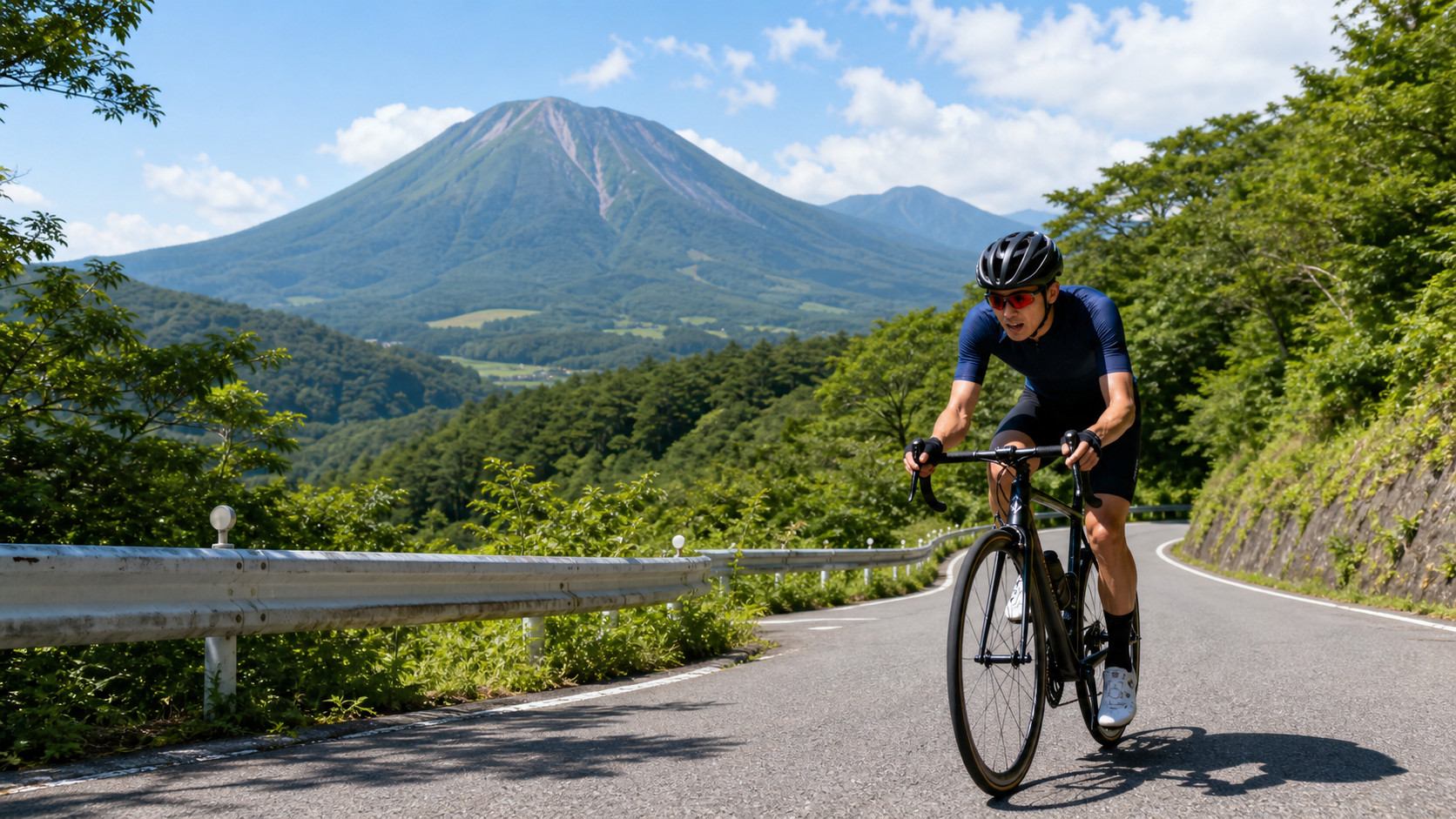
At the foot of the highest peak in the Chugoku region lies a short, steep, concentrated climb—this 3.5 km stretch on the Daisen Circular Road is the most direct, unforgiving punch at the base of “Hakufuji.” It’s not long, but its solid gradient forces you to show your true strength in a short amount of time.
Let’s start with the data and context. Mount Daisen (だいせん) stands at 1,729 meters, the highest peak in Tottori Prefecture and the Chugoku region. Due to its beautifully conical shape, it is nicknamed “Hakufuji (ほうきふじ),” and its foothills span Daisen Town, Hoki Town, and other areas. The “Daisen Circular Road” loops around the mountain, approximately 64 km in circumference, and has been selected as one of the “100 Best Roads in Japan.”
For Taiwanese cyclists, the name Daisen may not be as famous as Mount Fuji, but its status in the Chugoku region (western Honshu) is significant—it is the highest peak in the area, a sacred site of mountain worship, and home to the largest ski resort in western Japan. The circular road that encircles it has also been chosen as one of the “100 Best Roads in Japan,” making it a classic route among driving and cycling enthusiasts in Japan. Whether you want to take on the long-distance climbing of the full loop or just attack a short, steep climb for training, Daisen offers the challenge you’re looking for.
The climb segment featured in this article has the following stats: approximately 3.49 km in distance, about 300.6 meters of elevation gain, and an average gradient of 7.7%—this is a short, steep climb on the circular road, not the full loop. This kind of “short distance, high gradient” segment has a distinct character: it doesn’t test your endurance, but rather your ability to output power in a short time and handle steep slopes.
In other words, this is an “explosive” type of challenge, completely different from the “endurance” type of long climb like the Fuji Skyline. For a cyclist with a training base, 3.5 km can be climbed in about ten to fifteen minutes at moderate-to-high intensity, but the 7.7% average gradient, possibly mixed with steeper sections, will keep you in a higher heart rate zone throughout those ten-plus minutes. It’s well-suited as a “climbing power interval” segment—attack it at near-maximal intensity and treat it as a high-quality training stimulus. Understanding this “short, steep, explosive” character is the first step in planning this route.
1. Route Overview and Actual Data
| Item | Data |
|---|---|
| Distance | Approx. 3.49 km |
| Elevation Gain | Approx. 300.6 m |
| Average Gradient | 7.7% |
| Location | Hoki Town area, Tottori Prefecture (Daisen foothills) |
| Part of | Daisen Circular Road (100 Best Roads in Japan) |
| Difficulty Rating | Short steep climb (sprint / interval training type) |
2. Three Scales: Don’t Mix Up the Data
To properly understand this road, you first need to distinguish between three different “Daisen climbs” to avoid confusing the data:
- This article’s Strava segment: Approx. 3.49 km, 7.7% average, a short steep climbing practice segment on the circular road.
- The full Daisen Circular Road loop: Approx. 64 km around, with continuous ups and downs and almost no flat sections; total elevation gain can exceed 2,000 meters, making it an advanced long-distance challenge.
- The official “Hill Climb in Daisen” race course: Starting from sea level at the coast, finishing at Daisen Ski Resort, 17.3 km long, 814 meters of elevation difference, approx. 829 meters of total gain, 5.5% average gradient, with gentle slopes in the first half and 12% steep sections plus hairpin switchbacks in the second half.
These three are completely different challenges, and their data must not be mixed up. This guide focuses on the first one—that 3.5 km short steep climb.
Why is this worth emphasizing? Because many out-of-town cyclists, when doing their homework, easily mix up data from different sources, leading to incorrect preparation. For example, if you assume “the Daisen climb is only 3.5 km” and go light on gear, but then actually ride the full 64 km loop with over 2,000 meters of elevation gain, your supplies and energy reserves will be seriously inadequate—even posing safety risks. Conversely, if you prepare to the standard of the “advanced full-loop challenge” but only plan to ride this 3.5 km short climb for practice, that’s overkill. So before setting off, you must be clear: which scale of “Daisen” are you riding today? This awareness directly determines your equipment, supplies, and mental preparation.
3. Section-by-Section Guide (Pacing a Short Steep Climb)
The Start: Don’t Be Fooled by the Short Distance
3.5 km sounds short, and many people instinctively think, “It’s so short, just power through it.” But a 7.7% average gradient means this is a solid, formidable climb, and it might just be one segment of a larger ride (such as the full circular road loop). Key principle: first assess where this segment fits in your overall ride. If it’s a standalone short climb challenge, you can boldly attack at higher intensity; if it’s just one part of a long loop, you need to conserve energy and not blow up here.
This “assess the context first” mindset is what separates smart riders from reckless ones. Reckless riders see a slope and charge, and if this is just one part of a long ride, they often collapse later. Smart riders ask themselves first: “What role does this segment play in my overall plan today?” and then decide how much effort to put in. The same 3.5 km climb requires completely different optimal riding strategies depending on whether it’s a “standalone challenge” or “part of the full loop.” This seemingly simple judgment is actually the fundamental skill for riding any road well.
The Middle: Maintain Rhythm, Handle the Steep Sections
The key to a short steep climb is maintaining a steady, somewhat high output over a limited distance. On a 7.7% average gradient, there may be steeper sections mixed in. When you hit a steep point, shift to an easier gear and raise your cadence, avoiding grinding a big gear that causes lactic acid to pile up instantly. You’ll be at moderate-to-high intensity the whole way, and heavy breathing is normal.
Unlike long climbs, short steep climbs allow more room for error in pacing—because the distance is short, even if you go out slightly too hard, you can usually still make it to the finish. But that doesn’t mean you should charge without any strategy. A smarter approach: start at an intensity that’s “high but sustainable,” flexibly downshift to maintain cadence when hitting steep sections in the middle, and save your hardest punch for the final sprint. This way, you take full advantage of the short distance to get a good time without blowing up midway and ruining the whole segment’s performance. If you ride with a power meter, you can observe your power curve and practice distributing your effort smoothly across these 3.5 km—that in itself is excellent training.
The Finish: Final Sprint on a Short Climb
Because the distance is short, you can add pressure in the final stretch and use up whatever energy remains. Short steep climbs are great for interval training—climbing these 3.5 km at near-maximal intensity is excellent climbing power practice.
If you want to maximize the training value of this segment, here’s how you can arrange it: ride from start to finish at a high intensity you can sustain for about 10–15 minutes (roughly 100–110% of FTP), treating it as a complete “threshold interval.” A climb of this length falls right into the golden zone for improving “aerobic power” and “lactate tolerance.” After finishing, recover fully, and if your energy allows, you can even repeat it multiple times (if the road allows safe turnarounds) to form a set of intervals. Of course, if you’re riding the full circular road and this is just one part of the journey, do the opposite—conserve energy, pass through at a sustainable intensity, and don’t burn up your reserves for the later sections here.
4. Gearing and Equipment
- Chainring: A compact 50/34 is sufficient for a 7.7% average gradient; this kind of slope doesn’t require ultra-light gearing for extreme ramps.
- Cassette: An 11–32T is enough for most riders; if this segment is part of a longer ride, or you want things a bit easier, an 11–34T will be safer and more energy-efficient.
- Cadence: On steep sections, maintain at least 60 rpm to avoid dropping into a deadly low cadence, which will instantly overload your leg muscles.
In terms of equipment, this segment itself is short and not at high altitude, but if you’re riding the full circular road (over 2,000 meters of elevation gain), you need to prepare as for a long mountain climb: bring plenty of water (supply points along the circular road are extremely scarce; it’s recommended to carry 2 liters or more), food, and warm layers.
Here again, the importance of “distinguishing the scale” is emphasized. If you’re only riding this 3.5 km short climb, your gear can be very light—a bottle of water and simple snacks are enough. But if you’re riding the full loop, that’s a completely different preparation standard: it’s a challenge with over 2,000 meters of elevation gain, nearly a full day’s effort, with very few supply points. You must prepare as if embarking on a long, self-sufficient expedition. Not bringing enough water or food is a very real risk on a circular road with scarce supply points. So before you set off, confirm once more: which scale of Daisen are you riding today? Then prepare your equipment and supplies according to that scale.
5. Food and Hydration
- If only riding this short climb: bring one bottle of water and some snacks as backup; the burden is light.
- If riding the full circular road: This is extremely important—supply points along the way are very scarce, mainly only near Daisen-ji Temple, Masumizu Highland, and Okudaisen. Be sure to carry plenty of water (2 liters or more) and food; don’t expect shops to be available everywhere along the route.
- Feeding rhythm: On long climbs, it’s recommended to eat regularly every 30–40 minutes, not waiting until you’re hungry. On a circular road with scarce supply points, this “proactive, regular” feeding habit is especially important to avoid hitting a low-blood-sugar wall in a stretch with no services in sight.
- Stock up before departure: Japanese convenience stores are well-equipped. Stocking up in a town at the base of the mountain (such as Yonago City) before departure is the safest approach. Once you’re up the mountain, don’t count on finding shops everywhere.
6. Scenic Highlights Along the Way: Kagikake Pass and Masumizu Highland
The most famous viewpoint on the Daisen Circular Road is Kagikake Pass (かぎかけとうげ). It faces the south face of Daisen—that rugged, wild mountainside is the mountain’s most awe-inspiring aspect. In autumn, the beech trees blaze with fall colors here; in spring and summer, fresh greenery fills the valley with breathtaking beauty. If you’re riding the full circular road, Kagikake Pass is an unmissable stop.
From the west, Daisen has a gentle, graceful conical silhouette resembling a small Fuji—this is the origin of its “Hakufuji” nickname. But when you stand at Kagikake Pass and face its rugged, steep south face, you’ll see a completely different Daisen—precipitous, rough, full of primal power. One mountain, two entirely different faces; this contrast is the most fascinating part of riding around Daisen. Stop at Kagikake Pass and take time to gaze at this south face. You’ll temporarily forget the effort of the climb, leaving only a profound sense of awe for this mountain.
Additionally, along the circular road there are other spots like Masumizu Highland (elevation approx. 900 meters, with a sky chairlift offering views of the Sea of Japan and Yonago City’s nightscape) that are worth stopping at when circling Daisen. The sky chairlift at Masumizu Highland operates from April to November, taking you to an even higher vantage point where the Sea of Japan and the cityscape of Yonago spread out before you, with the night view being especially enchanting. If you’re riding the full circular road, these viewpoints scattered along the way will make your ride not just a climb, but a journey around a famous mountain, taking in spectacular scenery.
7. The Full Circular Road: An Advanced Challenge
If you’re not satisfied with this 3.5 km short climb and want to take on the full Daisen Circular Road, that’s a battle of an entirely different level.
The full loop is about 64 km, with continuous ups and downs and almost no flat sections to catch your breath. Cumulative elevation gain can exceed 2,000 meters, making it clearly an advanced-level challenge. It’s been selected as one of the “100 Best Roads in Japan,” and along the way it connects the south-face scenery of Kagikake Pass, the viewpoints of Masumizu Highland, the spiritual atmosphere of Daisen-ji Temple, and the largest primeval beech forest in western Japan. This is a complete route that lets you appreciate Daisen’s many faces from every angle while thoroughly testing your physical limits—a highly rewarding ride.
But to ride the full loop, your logistics must be in order: supply points along the way are extremely scarce (mainly only near Daisen-ji Temple, Masumizu Highland, and Okudaisen), so be sure to carry plenty of water (recommended 2 liters or more) and food. Additionally, over 2,000 meters of cumulative climbing plus mountain weather require you to bring warm layers and allow ample time. Treat the full circular road as a “full-day famous mountain circuit challenge” and plan it seriously—get your supplies, warm clothing, and time all sorted, and you’ll be able to complete this grand tour around Hakufuji safely and enjoyably.
7. Common Mistakes and DNF Risks
- Mixing up the data: Confusing the stats of the short segment, the full loop, and the race course, leading to incorrect preparation (e.g., thinking it’s only 3.5 km, then discovering on the full loop that you’re climbing over 2,000 meters). This is the most common and most dangerous planning error on Daisen.
- Starting the short climb too hard: If this segment is part of a longer ride, charging hard at the start will drain your energy for the later sections, making the rest of the road even tougher.
- Insufficient supplies for the full loop: Riding the full loop without enough water and food, on a circular road with very few supply points, is the most dangerous mistake and the most likely to lead to an accident.
- Narrow road sections and oncoming traffic: The circular road has narrow sections; be alert to oncoming vehicles and passing safety. Driving guides often recommend pulling left to yield on narrow stretches, and cyclists should likewise stay vigilant and keep to the side courteously.
Training Value of the Short Steep Climb
It’s worth noting that this 3.5 km, 7.7% short steep climb on Daisen is actually a high-quality training resource. For cyclists looking to improve their climbing ability, this kind of “moderate length, solid gradient” segment falls right into the golden zone for building “threshold power” and “climbing-specific strength.”
If you use it for training, here’s how you can arrange it: after a thorough warm-up, attack from start to finish at an intensity at or slightly above FTP, recording your time and power; after full recovery, if conditions and safety allow, repeat a few more times to form a set of intervals. With consistent practice, you’ll see your climbing power steadily improve. And the magnificent scenery at the southern foot of Daisen makes this otherwise monotonous interval training much more pleasant—training on a climb with stunning views is a real privilege.
8. Target Times for Different Rider Levels
The following are reference times for the Strava segment (approx. 3.49 km, approx. 300 meters of climbing):
| Rider Level | Reference Completion Time |
|---|---|
| Advanced competitive | Approx. 12–15 min |
| Steady cruiser | Approx. 16–20 min |
| Sightseeing challenger | Approx. 21 min or more |
Because the distance is short, this segment is great for “going for a personal best”—recording your time and coming back later to challenge it and see if you’ve improved is a highly rewarding way to train. Of course, if you’re treating it as part of the full circular road, don’t obsess over the seconds on this one segment; conserving energy to complete the entire loop is what matters.
9. Race: Hill Climb in Daisen
This area hosts an official “Hill Climb in Daisen” hill climb race, with registration at the Tottori Prefecture Nawa General Sports Park (Daisen Town). It starts from sea level at the coast and finishes at Daisen Ski Resort, covering 17.3 km with 814 meters of elevation difference, an average gradient of 5.5%, gentle slopes in the first half (with grassland scenery), and 12% steep sections plus hairpin switchbacks in the second half. Finishers also enjoy all-you-can-eat Genghis Khan BBQ at Gōen-zan Lodge. Note: this race course is different from both the 3.49 km short segment and the full circular road covered in this article—don’t mix up the data. If you want to challenge Daisen in a race format, this event is the most representative choice.
This race has a very romantic design—starting from sea level at the coast. This means you begin at the shore of the Sea of Japan and climb all the way up to Daisen’s ski resort, experiencing the full vertical drop “from sea to mountain.” This kind of “sea-level start” hill climb is relatively rare in Japan, and it lets you truly feel your body being “lifted” from sea level to the mountains. The first half’s gentle slopes cross open grassland scenery, while the second half has 12% steep sections and continuous hairpin switchbacks waiting for you—this “gentle first, steep later” course design is a real test of your energy distribution and pacing wisdom. And the all-you-can-eat Genghis Khan BBQ at Gōen-zan Lodge after finishing is the most comforting, eagerly anticipated ending to this hard battle. If your schedule can align with the race date, making “participating in Hill Climb in Daisen” your way of challenging the mountain will be an unforgettable experience (the exact race date, entry slots, and registration method all need to be confirmed with the organizers in advance).
10. Fitting Daisen into Your Itinerary
Daisen is located in Tottori Prefecture. For out-of-town and overseas cyclists, logistics and itinerary planning are just as important as physical fitness.
Choosing a base: You can base yourself in Yonago City (the city on the west side of Daisen, with convenient transport and full amenities) or at resort facilities in the Daisen foothills. Yonago is close to Daisen, well-equipped, and has convenience stores, restaurants, and accommodation, making it a good base before and after riding, and convenient for stocking up on supplies before departure.
Choosing a season: Daisen is snowbound in winter (ski season runs roughly late December to late March), and the circular road and related highland sections are closed in winter, so the best seasons for cycling are late spring through autumn. Spring’s fresh greenery, summer’s coolness, and autumn’s fall colors at Kagikake Pass each have their own appeal; the autumn foliage at Kagikake Pass, facing the south wall, is especially famous and draws many photographers and cyclists specifically for it—arguably the most beautiful time of year on Daisen.
Time planning: If riding the full circular road, this is a nearly full-day itinerary. Be sure to start in the morning, allow ample time, and have supplies and warm layers ready; if only attacking the short climb, you can arrange things more flexibly, even fitting it into a larger cycling trip around Tottori and the Hiruzen Highlands. Either way, it’s recommended to schedule the climb during stable weather, avoiding possible afternoon changes, so you have plenty of leeway to complete the ride at a comfortable pace.
Conclusion
This 3.49 km, 7.7% short steep climb on the Daisen Circular Road is the most direct punch at the base of “Hakufuji.” It’s short in distance but solid in gradient, well-suited as an interval workout for climbing power, and ideal for riders who want a quality climb in a limited time. And if you expand your view to the full circular road, that’s another advanced challenge with over 2,000 meters of elevation gain requiring a full day and thorough preparation. This flexibility of “one road, multiple scales” is what makes Daisen so appealing—it can satisfy both those who just want to ride a short segment and those who want to circle an entire famous mountain. Whichever scale you choose, as long as you have the right gearing, keep the data scales straight, and (if riding the full loop) bring enough supplies and warm layers, you can fully enjoy the ride where climbing and scenery intertwine at the foot of the Chugoku region’s highest peak. The moment you stand at Kagikake Pass facing the south face of Daisen, you’ll understand that this “Hakufuji” is worth a special trip.
Let me sum up the essence of Daisen climbing strategy in one sentence: First, be clear about which scale you’re riding (short segment / full loop / race course), then prepare your equipment, supplies, and mindset according to that scale. For the short segment, attack it like an explosive interval; for the full loop, plan it like a full-day expedition; for the race, follow official information to register. Get this most basic—and most crucial—thing right, and you’ll be able to safely and enjoyably experience your own “Daisen” at the foot of the Chugoku region’s highest peak. Whichever you choose, the awe-inspiring south face at Kagikake Pass will be the most unforgettable image of your journey.
Related Reading
- Faith and Pastoral Scenes of Hakufuji: A Journey on the Daisen Circular Road, Kagikake Pass South Face, and Foothill Dairy Farms
- 99 Turns, One Road: Tianmen Mountain Highway, a Visual Spectacle Concentrating Wuling’s Steepest Sections
- Daxueshan 32 km Long Climb Practical Guide: An Endurance Mountain from Dongshi Gaining 1,557 Meters
- Comparison of Taiwan’s Top Ten Classic Climbing Routes: Gradient, Distance, and Difficulty Analysis
台北闊瀨陡坡 騎旅 / 日本單車雜誌編輯車友臨時加入!/ 髮香才是最強的 / feat. 北迴歸線小隊 / 公路車 CT Yeh
6 個月前
大武山後門26%歡樂陡坡!JJSC南台灣單車行Day2 / 被颱風追著跑 / 公路車 / CT Yeh
2 年前
半日 小台灣 極限單車路線挑戰實錄
7 年前
大禹嶺 到 武嶺牌樓 全程前後實況錄影 | 北進武嶺 | 東進武嶺 | KOM | 訓練台 | 坡度分析 | Taiwan KOM Last 10 km HARD | 公路車
6 年前
新竹羅平 x 天湖部落 大禹嶺級變態陡坡! 4K超高畫質 空拍 | 公路車
5 年前
嘉義大埔、阿婆灣挑戰賽,美到以為在日本!ft. 環騎5 Cool 西拉雅188 / 公路車 / CT Yeh
7 個月前
宇老大滿貫 拉拉山 員工旅遊 有如爬了一座東進武嶺 #公路車 4K高畫質
6 年前
觀霧 變好騎了! | 北高車友爆笑大會師 | 公路車 | 單車旅遊 Taiwan Cycling Route GuanWu
6 年前