Route Overview and Real Data Analysis
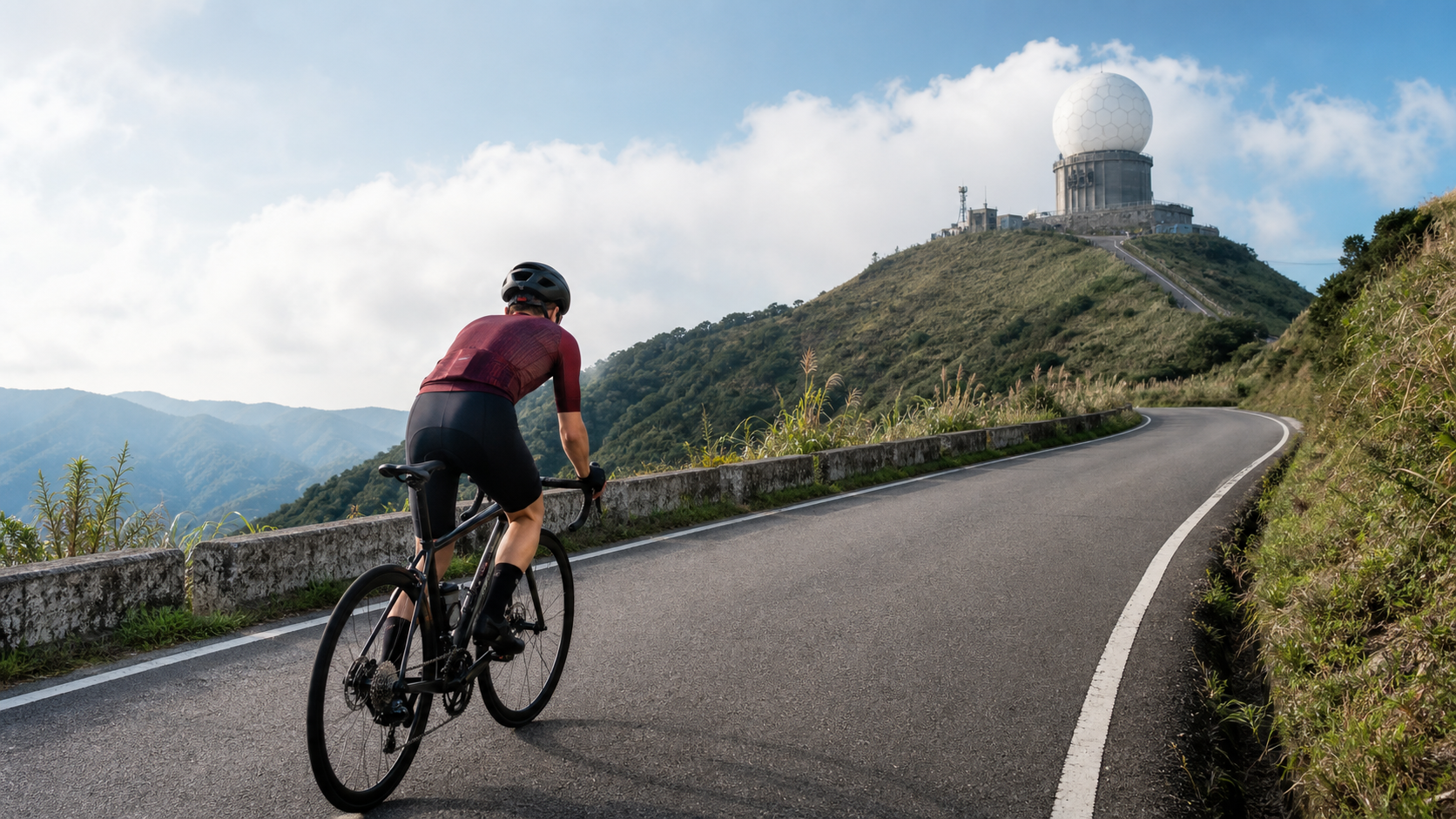
Wufenshan, at an elevation of approximately 757 meters, sits in the mountainous area where Pingxi, Ruifang, and Xizhi districts of New Taipei City meet. The massive white radar dome at the summit — the Central Weather Administration’s Wufenshan Weather Radar Station — is not only a critical piece of infrastructure for disaster-prevention meteorological monitoring in northern Taiwan, but for cyclists, it also serves as the most distinctive visual endpoint marker on this route. Spot that dome from afar, and you know the finish isn’t far off.
Let’s lay the numbers out first. The official record for this route is:
- Total distance: 10,276.6 meters (approximately 10.28 km)
- Total elevation gain: 577.4 meters
- Average gradient: 5.4%
If you simply multiply distance by gradient to back-calculate the theoretical elevation gain, 10.28 km × 5.4% ≈ 555 meters — a difference of about 22 meters from the database’s recorded 577.4 meters, which falls within a reasonable GPS elevation measurement error range (GPS elevation data in mountainous areas typically fluctuates by 5–10% due to signal reflection, tree canopy obstruction, and other factors). What does this mean? It means the gradient distribution on this route is relatively uniform — it’s not one of those polarized routes that are “gentle first, steep later” or “steep first, gentle later.” Instead, it maintains a relatively steady climbing rhythm throughout, allowing riders to apply the same pacing logic from start to finish.
From a coaching perspective, this characteristic is crystal clear: Wufenshan is a highly predictable training route. Unlike routes where the gradient constantly shifts between steep and mild, forcing your power output to keep jumping to match the terrain, Wufenshan is closer to a tempo-riding workout where you “set a target wattage or heart-rate zone, then try to hold it.” For riders looking to practice sustained, steady power output over a longer duration (commonly known as FTP endurance or threshold training), the terrain characteristics of this route happen to provide the ideal training scenario.
At 10.28 kilometers, the distance sits between “short, explosive climbs” (like many well-known 3–5 km time-trial segments) and “long, endurance climbs” (Wuling-class routes that stretch 15 km or more), placing it firmly in the mid-distance climbing category. This length is sufficient to magnify the cost of pacing mistakes — if you go out too hard in the early stages, you will pay for it in the second half. But unlike Wuling, it’s not so long as to intimidate casual recreational riders. You could say Wufenshan is an excellent touchstone for “advanced beginners” and “intermediate riders” to practice climbing pace management.
At a 5.4% average gradient, it falls in the range of “continuously noticeable but not enough to blow you up.” Compared to the relentless 8–10% sustained steep sections found on Yangjin Highway, Wufenshan’s gradient feels closer to the gentle climbing sensation of certain sections on the Beiyi Highway or the Beihuan road — you’ll breathe hard and feel the fatigue, but if you pace yourself well, it’s a route where you can complete the majority of the climb seated (in-saddle climbing) without having to stand and grind the entire way.
Section-by-Section Strategy: Breaking 10.28 km into Four Tactical Zones
To ride this route well, it’s recommended to break the 10.28 km into four tactical zones — both mentally and physically — rather than treating it as one unbroken stretch of suffering.
Section 1 (0–2.5 km): The Opening Attack — Lock Down Your Heart Rate, Don’t Let Adrenaline Fool You
The first mistake most riders make at the start of a climb is being deceived by the illusion of “just started, legs still feel fresh” and surging out with power or heart rate beyond what they can sustain. The early part of Wufenshan climbs gently into the route, and this section has only one task: keep your heart rate or power pinned at the lower edge of the zone you can hold for the entire ride.
In practical terms, ride at an effort that feels like “I should probably be going a bit faster” — that is, deliberately ride 5–10% slower than your instinct tells you to. This sounds counterintuitive, but the biggest enemy on a long climb is never your physical limit — it’s the pacing misallocation of “wasting it early, having nothing left late.” For cadence, aim to maintain a mid-to-high spin of 85–95 rpm, using a lighter gear to keep your muscles in the aerobic-dominant zone and avoid accumulating lactate too early.
Section 2 (2.5–6 km): The Sustained Mid-Climb — The Core Test of Rhythmic Riding
This is the section that best showcases the route’s “uniform gradient” character, and it’s also the most important pacing-management zone of the entire ride. Because the gradient doesn’t fluctuate dramatically, the most likely issue here is actually mental monotony and fatigue — there’s no obvious flatter stretch to catch your breath on, and no short steep pitch to spike your adrenaline. It’s just continuous pedaling, pedal, pedal.
For this section, the recommended approach is a “segmented mental anchor” strategy: break the middle section down into one small goal per kilometer, using each kilometer marker or a distinct landmark (such as a bend or a farm-road junction) as a mental aid station, rather than staring at how many kilometers remain. Keep your power or heart rate as close as possible to the zone you set in Section 1. If you notice your heart rate starting to creep slowly above your target zone, that’s your body telling you the pace is slightly too fast — ease off a bit. That’s far more cost-effective than pushing through and collapsing in the later stages.
Section 3 (6–8.5 km): Terrain Transition and the Mental Barrier
On most climbing routes, this distance range tends to bring gradient changes or shifts in scenery, and Wufenshan is no exception. As elevation rises, the vegetation transitions from secondary forest to more open terrain, and the wind becomes noticeable — a signal that the mountain’s microclimate is shifting. In this section, riders are advised to consciously “listen to their breathing” — if your breathing rhythm can still sustain speaking two or three words without gasping, your pace is still within controllable range; if you’re down to squeezing out single syllables, you’re going too fast and must back off immediately.
This is also the zone where the mind is most likely to waver, because physical fatigue has accumulated but the finish line is still out of sight. At this point, shift your focus from “how much longer” to “how far I’ve already come” — you’ve completed 70–80% of the entire route. This mental reframing provides tangible help in maintaining motivation.
Section 4 (8.5–10.28 km): The Final Push Toward the Weather Radar Station
When the outline of that white radar dome begins to come clearly into view at the summit, you’ve entered the final stretch. This section is one of the few places on the entire ride where you can (and should) release a bit of your reserved energy — provided you’ve paced the first three sections well and still have something left in the tank.
If you believe your pacing in the earlier sections was on point, you can try raising your cadence and standing to sprint the final few hundred meters, using the clearly visible endpoint landmark as your source of motivation. But if you’ve already shown signs of slowing in the earlier sections, the correct approach here is to abandon any sprint ambitions and adopt a conservative finish, riding out the remaining distance in the most efficient way possible to avoid cramping or complete exhaustion — the most wasteful outcome on a climbing route is being forced to dismount and walk with only a few hundred meters to go because you pushed too hard on a desperate sprint.
Gear Ratio and Equipment Recommendations: Rhythm Over Explosiveness
The combination of Wufenshan’s 10.28 km and 5.4% average gradient points very clearly toward a “rhythmic riding” rather than “explosive sprinting” equipment philosophy. This isn’t a route that demands ultra-light gearing to grind up steep pitches (like certain sections of Yangjin Highway that may require a 34-32 or even lighter setup), but it’s also not a gentle enough slope to muscle through with heavy gears.
Gear ratio recommendations:
- Front chainrings: It’s recommended to use a 52/36 or 50/34 compact or semi-compact crankset, avoiding a pure racing 53/39 standard crankset unless you have a solid foundation of climbing strength.
- Rear cassette: It’s recommended to have at least an 11-30T or 11-32T cassette, so that when your strength fades in the middle-to-late stages, you still have a light enough gear to maintain a cadence above 85 rpm without being forced into a heavy grind at 60–70 rpm.
The emphasis on rhythm over explosiveness is because the 5.4% gradient range sits right around the dividing line between “can ride the entire climb seated” and “must frequently stand and sprint.” Using lighter gearing paired with a higher cadence distributes more of the climbing load to your cardiorespiratory system rather than the muscular strength of your quadriceps — for a mid-to-long distance climb like this 10 km route, that’s a more sustainable energy-use strategy. Frequent standing sprints may feel faster in the short term, but they deplete muscle glycogen at a far higher rate than seated rhythmic riding, making it easy to hit the wall prematurely in the middle-to-late stages.
Additional equipment recommendations:
- For wheels, there’s no need to chase ultra-light racing wheelsets; a mid-range training wheelset is sufficient. It’s more cost-effective to prioritize budget toward gear-ratio flexibility.
- Since the summit tends to be windy, it’s recommended to carry a lightweight windproof vest or arm warmers — they pack down small and are easy to put on or take off before and after reaching the top.
Nutrition, Hydration, and Seasonal Weather Advice: The Weather Station at the Summit Isn’t There for Nothing
The summit of Wufen Mountain is home to a radar station operated by the Central Weather Administration. This fact alone should remind riders of an important message: this is a key area for weather observation, which means the weather here is inherently changeable, windy, and foggy. This is no coincidence—weather station sites are typically chosen based on how representative the location is of regional weather systems and its observational conditions. Wufen Mountain, straddling the mountainous terrain where Pingxi, Ruifang, and Xizhi meet, happens to be a location where the northeast monsoon and orographic rainfall interact prominently.
Mountain weather changes rapidly, especially on the sections near the summit. Even if the skies are clear when you set off from the base, the summit may still be shrouded in clouds and fog, visibility can drop suddenly, and temperatures can be several degrees lower than at lower elevations. This is not an exaggeration—it’s a shared experience of every rider who has tackled mid-elevation mountain routes in northern Taiwan.
Hydration and Nutrition Advice:
- At 10.28 kilometers with an average gradient of 5.4%, most riders will complete the climb in 30 to 70 minutes (depending on ability). For this distance, one bottle of fluid in a single bidon is usually sufficient, but it is still recommended to adjust based on your personal sweat rate, and be sure to carry adequate fluids during hot summer conditions.
- Since there are no extreme steep sections requiring short, high-intensity bursts, nutrition doesn’t need to be as aggressive as it would be for a short sprint-style route. A regular sports drink or energy gel consumed before starting the climb should suffice, with additional intake as needed based on how you feel mid-climb.
Layering and Cold-Weather Advice:
- Even in Taiwan’s summer, the perceived temperature at the summit of Wufen Mountain can be significantly lower than at the base due to elevation and the topographic effects of the northeast monsoon. Combined with the risk of getting chilled when sweat meets wind, it is strongly recommended to carry a lightweight windbreaker or vest and put it on immediately upon reaching the summit for any extended stop.
- In autumn and winter (especially from October to February when the northeast monsoon intensifies), the cold and damp conditions at the summit become markedly worse. Be sure to strengthen your insulation layers, and gloves or long-finger gloves should also be on your packing list.
- Whether the summit offers sweeping views of Keelung Islet and the northeast coast depends heavily on the current weather and visibility. It is advisable to check the Central Weather Administration’s real-time information before riding, but regardless of the visibility on any given day, this remains a training ride worth completing.
Common Mistakes and DNF Risks: Three Major Pacing Pitfalls for Long Climbs
On a mid-length climbing route in the 10-kilometer range, the most common pacing errors that cause riders to abandon mid-ride (or finish but feel terrible) fall into three main categories:
Mistake One: Going Out Too Hard, Then Cratering in the Second Half
This is the classic and most common mistake. The uniform gradient of Wufen Mountain amplifies this problem—because there are no significant flatter sections to “recover” in the middle, once you’ve blown up in the early part, there’s almost no chance to recover in the latter half. The solution is detailed in the “Segment-by-Segment Strategy” section above: deliberately keeping intensity low at the start is the key decision point for pacing success on this entire route.
Mistake Two: Ignoring the Mental Monotony of the Middle Section and Forcing an Unsustainable Pace
The middle section (2.5–6 km) has a steady gradient and little change in scenery, which can easily create the illusion that “I can hold this pace,” leading riders to ignore the body’s fatigue signals. It is recommended to use real-time data from a power meter or heart rate monitor as objective indicators rather than relying purely on subjective feeling, because during prolonged steady climbing, subjective fatigue perception tends to be unreliable.
Mistake Three: Underestimating the Additional Toll of Summit Weather on the Body
Many riders only plan their energy expenditure for “finishing the 10.28 kilometers” and overlook that as they near the summit, dropping temperatures and strengthening winds themselves increase the body’s energy consumption and perceived fatigue. It is recommended to reserve a 5–10% buffer in perceived effort for the final 1–2 kilometers when planning your pace, to avoid unexpected slowdowns caused by environmental variables.
Reference Target Times for Riders of Different Levels
The time ranges below are for training reference only. Actual completion times will vary depending on individual daily condition, wind direction, road conditions, and riding equipment:
| Rider Level | Estimated Completion Time | Average Pace (Estimated Speed) | Characteristic Description |
|---|---|---|---|
| Elite Competitive | Approx. 30–35 min | Approx. 18–20 km/h | High proportion of standing out-of-saddle climbing; power output sustained above FTP |
| Advanced Rider | Approx. 36–45 min | Approx. 14–17 km/h | Primarily steady rhythm riding, good energy distribution, occasional out-of-saddle surges |
| Intermediate Rider | Approx. 46–55 min | Approx. 11–13 km/h | Primarily seated throughout; may need brief pauses to regulate breathing |
| General Recreational Rider | Approx. 56–65 min | Approx. 9–11 km/h | Segment-by-segment mindset; may stop for refueling or photos |
| Beginner / First Attempt | Approx. 66–70 min | Below approx. 9 km/h | Recommended to use a compact gearing setup; finishing is the primary goal |
The table data represents training reference ranges, not official race timing standards. Riders are advised to use their first ride record as a baseline and subsequently measure training effectiveness by “rate of improvement” rather than “absolute time.” This mindset is more conducive to maintaining long-term training motivation.
Power and Heart Rate Training Framework: Turning Wufen Mountain into Your Tempo Ride Training Base
Because Wufen Mountain features a uniform gradient and high predictability, this route is well suited to being incorporated into a regular Tempo or Threshold training plan—not just used as a one-off challenge goal.
Recommended Training Intensity Zone Reference:
| Training Goal | Power Zone (%FTP) | Heart Rate Zone (%LTHR) | Applicable Scenario |
|---|---|---|---|
| Aerobic Endurance Ride | 56–75% | 68–83% | Recovery rides or base-phase volume accumulation |
| Tempo Ride | 76–90% | 84–94% | Primary recommended training intensity; sustainable throughout |
| Threshold Ride | 91–105% | 95–105% | For advanced riders attempting personal best times |
| Anaerobic Sprint | 106% and above | Depends on individual | Recommended only for the final sprint section |
For riders looking to improve FTP or sustained power output, it is recommended to schedule Wufen Mountain as a fixed training route once a week or every two weeks. By consistently tracking power, heart rate, and completion time on the same segment, you can use the data as an objective quantitative indicator of training cycle effectiveness. This “fixed test route” training method is a well-established and effective practice in cycling training science, as it eliminates the confounding variables of route differences.
Positioning Compared to Other Notable Long Climbs in Northern Taiwan:
To place Wufen Mountain on the spectrum of northern Taiwan climbing routes, it can be understood roughly as follows—its combination of distance and gradient sits between typical short time-trial climbs (such as most well-known 3–5 km test segments) and long-distance challenge routes (such as the full Yangjin Highway or the multi-segment continuous climbs of the Beihuan). It represents a “mid-distance, mid-intensity” signature route. For riders still building their endurance base for long climbs, Wufen Mountain is an ideal stepping stone for progression; for riders with solid climbing ability, it is better suited as a fixed venue for tempo training or interval testing, rather than a route primarily targeted at “record-breaking attempts.”
Safety and Visibility Reminders Around the Summit Weather Radar Station
Finally, a special reminder about riding safety in the summit area. The Wufen Mountain Weather Radar Station is an important observation facility of the Central Weather Administration, and the surrounding roads and open areas are relatively limited. Combined with the windy and foggy conditions mentioned earlier, riders arriving at the summit area should pay special attention to the following points:
- Possibility of sudden visibility drops: Mountain clouds and fog move quickly, and visibility can drop from clear to just a few dozen meters in a short time. It is recommended to slow down when riding the summit section, especially at blind spots on corners and hilltops.
- Impact of strong winds on handling: The open terrain at the summit is prone to gusts, which can genuinely affect bike handling. Be sure to leave a margin of control when cornering and descending.
- Shared space with other road users: Besides bicycles, mountain roads may also have hikers and other vehicles. Please yield and maintain a safe distance when approaching the summit and the facility area.
- Brake management on the descent: After completing the 10.28 km climb, the descent also covers a 577.4-meter elevation drop. On long descents, be sure to brake intermittently rather than continuously on one side for extended periods, to avoid overheating the rims or rotors and causing brake fade.
To sum up the Wufen Mountain route in one sentence: it is neither the longest nor the steepest climbing route in northern Taiwan, but its steady and predictable gradient makes it an “honest” training route—your pacing ability will be clearly reflected in your finish time and perceived fatigue, with no luck involved and no unexpected terrain traps to blame. That is precisely its greatest value as a training route.
Pre-Ride Checklist and Route Planning Supplement
Before setting off, it is recommended to go through the following checklist item by item, especially for riders attempting this route for the first time. Thorough preparation often determines the quality of the day’s ride more than on-the-spot willpower.
Bike inspection priorities:
- Brake system: With a 577.4-meter descent, be sure to check the remaining thickness of your brake pads or disc pads before departure to avoid reduced braking power from insufficient pad material during the long descent.
- Tire pressure and condition: Mountain roads may have fallen leaves, loose gravel, or even slippery sections (especially after rain). Adjust tire pressure according to the day’s weather and your body weight, and check the tires for obvious cracks or embedded debris.
- Drivetrain: Since this route emphasizes rhythmic riding and frequent gear adjustments, check that front and rear shifting feels smooth before departure to avoid chain skipping or jams disrupting your pacing rhythm during climbs.
Personal gear checklist:
- Basic repair tools (spare tube, pump or CO2 inflator, tire levers, multi-tool)
- Windproof and thermal layers (adjust thickness by season)
- Plenty of water and nutrition (assess based on your sweat rate and the day’s temperature)
- Bike lights (if planning to start in the early morning or evening, as lighting conditions on mountain roads are limited)
- Phone or GPS device (some mountain sections may have unstable signals; download offline maps before departure)
Additional route planning suggestions:
- Since Wufen Mountain spans the border of three districts—Pingxi, Ruifang, and Xizhi—there may be more than one possible climbing route. Before riding, rely on on-site signage and official map information to confirm that your planned route matches the 10.28 km, 577.4-meter climb described in this article.
- It is recommended to avoid departing in the afternoon on weekends and holidays. Mountain roads are mostly two-way single-lane, and when holiday traffic increases, the safety risk of passing and overtaking also rises. Choosing a weekday or an early morning on holidays is a better option.
- For group rides, clearly agree on meeting points and a contingency plan for getting separated before departure. Since signals are unstable on some mountain sections, verbal agreements are more reliable than relying on real-time messaging.
Final recommendation: Put Wufen Mountain into your annual training cycle
For riders who take their improvement curve seriously, it is recommended not to treat Wufen Mountain as just a one-and-done checklist item, but rather to build it into a regular training cycle—for example, challenging it once or twice a month, and carefully recording each finish time, average power, average heart rate, and subjective fatigue rating (RPE). Through long-term data accumulation, you will find that the greatest value of this route lies not in its difficulty per se, but in serving as a “stable yardstick” that faithfully reflects the actual progress of your training results at each stage. This kind of traceable, comparable training record supports long-term fitness planning and goal setting far better than a one-off record-breaking sprint.
Related Reading
- Pingxi Wufen Mountain Guide: A Hard-Core Short Climb in Ruifang with 4 km, 257 m of Elevation Gain, and a 6.4% Average Gradient
- Wuzhi Mountain Practical Guide: 10 km, 839 m of Elevation Gain—Don’t Be Fooled by the “5.7% Average”
- The White Sphere Ten Kilometers Away: A Ride into the Clouds and Light of Wufen Mountain
- The White Giant Ball Above the Clouds: A Foggy Ridge Ride to Pingxi’s Wufen Mountain
半日 小台灣 極限單車路線挑戰實錄
7 年前
台北闊瀨陡坡 騎旅 / 日本單車雜誌編輯車友臨時加入!/ 髮香才是最強的 / feat. 北迴歸線小隊 / 公路車 CT Yeh
6 個月前
水金九不厭五分 10度寒流冷到不願停!feat. 卡卡 / 公路車 / CT Yeh
6 個月前
太平山單車員工旅遊 | 這樣玩CP值最高!| 公路車
5 年前
單車 梅山36灣 坡度介紹 路段介紹 空拍 (相關遊記影片,請參考說明或我的頻道喔,歡迎訂閱)
6 年前
騎單車去大屯山賞雪! 助航台滑冰 全記錄 | 台北R友大集合 | 下雪打雪仗囉 | 4K超高畫質
5 年前
大武山後門26%歡樂陡坡!JJSC南台灣單車行Day2 / 被颱風追著跑 / 公路車 / CT Yeh
2 年前
#公路車 #西進武嶺 配速配瓦實驗 坡度分析 四小時內攻略 建大盃 NeverStop #西進武嶺攻略
6 年前