Tucheng Guanzizai Practical Guide: 3km with 220m of Climbing — Breaking Down This Hidden Steep Slope with Data
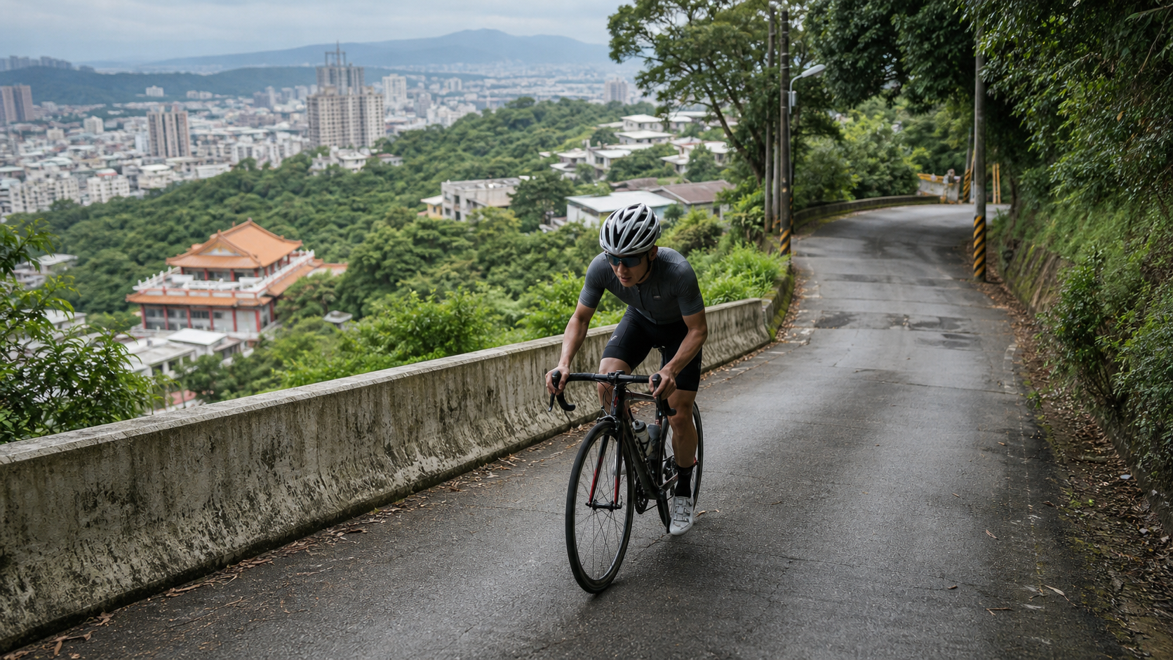
Distance 2.996 km, elevation gain 220.8 m, Strava average gradient 5.8%, climb category Category 2—Tucheng Guanzizai is a short climbing route in New Taipei City’s Tucheng District, tucked away at the boundary between the suburbs and the mountains. It’s not long, but it’s absolutely not easy—the kind of route that people underestimate before setting off, only to realize mid-climb that “something’s off.”
The name of this road is quite distinctive—“Guanzizai” carries Buddhist imagery, and riders familiar with local culture naturally associate it with the well-known temple atmosphere in the nearby mountains. But setting aside the poetic name, this article is about something more practical: how to break down this 3-kilometer climb with data, so you know what gearing, what pacing, and what mental preparation to bring to it.
1. First, Understand the Data: The Gap Between Official Gradient and Calculated Figures
Before planning any pacing strategy, you must honestly confront a data discrepancy. Tucheng Guanzizai’s official Strava average gradient is listed as 5.8%, but if you divide the total elevation gain of 220.8 meters by the route distance of 2996.1 meters, the resulting figure is approximately 7.37%—nearly 1.6 percentage points steeper than the official average.
This discrepancy isn’t a typo, and you don’t need to pick one number and ignore the other. A more reasonable interpretation is that Strava’s gradient algorithm typically applies smoothing to the route’s horizontal projection distance and elevation changes, while the simple division of actual elevation gain by distance reflects the most intuitive ratio of “vertical gain to horizontal distance.” When the two diverge, the most common cause is a section in the middle of the route with gradients significantly steeper than the overall average, concentrating the total elevation gain into a shorter segment—making the simple division yield a steeper figure than the officially smoothed segment average. In other words, this data gap itself is a warning sign—it’s telling you that this road isn’t a steady 5.8% gradual climb, and the middle section very likely hides short, steep pitches approaching or even exceeding 10%.
| Calculation Method | Average Gradient | Significance |
|---|---|---|
| Official Strava Listing | 5.8% | Official segment-smoothed average gradient |
| Elevation ÷ Distance Calculation | ~7.4% | Unsmoothed direct ratio, reflecting actual perceived difficulty |
For routes with this type of data discrepancy, the safest approach is to “prepare mentally for the steeper figure, use the official figure as a reference”—meaning, before you set off, set your expectations for 7% or even steeper mid-section pitches, rather than naively assuming the entire route is a gentle 5.8% slope that can be easily spun while seated. This is the most important first lesson of this road: short doesn’t mean easy, and the average doesn’t mean there are no landmines.
2. What the Category 2 Climb Classification Means
Strava’s climb categorization system (Category) is a difficulty metric calculated from a combination of gradient and distance—the smaller the number, the harder the climb (HC is the highest tier, followed by Category 1 through Category 4). Tucheng Guanzizai is classified as Category 2, which is a fairly serious rating for just 3 kilometers—by comparison, many Category 2 segments spanning 8 to 10 kilometers earn their difficulty score through sustained climbing over long distances; Guanzizai, on the other hand, squeezes into the same difficulty tier almost entirely through “short distance, high instantaneous gradient.” This again echoes the gradient discrepancy mentioned in the previous section: its difficulty isn’t built on length—it’s built on steepness.
For riders, the practical meaning of this classification is: don’t approach it with a “it’s only 3 kilometers, I’ll be done in no time” mindset, but rather prepare with the mental intensity you’d bring to a medium-length hard climb.
3. Segment-by-Segment Strategy: A Three-Part Breakdown to Cut the Steep Sections into Manageable Rhythms
Segment 1 (0–1 km): Gentle Entry, Quickly Settle into Climbing Rhythm. The attack on Guanzizai typically begins from the Tucheng urban side, where the road surface is smooth and the gradient relatively mild—the only section on the entire route where you can catch a brief breather and adjust your cadence and breathing. For this section, keep cadence at 80–90 rpm, stay in the middle chainring, and bring your heart rate from flat-road cruising into Zone 3. Don’t rush to push higher output here, because the upcoming sections will quickly consume any excess energy reserves.
Segment 2 (1–2 km): The Core Steep Zone, the Most Demanding Section of the Entire Route. This is where Guanzizai truly defines its difficulty. Based on the gradient discrepancy analysis mentioned earlier, instantaneous gradients in this section very likely exceed 10%, with some stretches possibly reaching short-wall levels of 12%–15%. Facing this steepness, alternate between standing and seated climbing—prolonged standing will spike your heart rate and accelerate lactate buildup; prolonged seated grinding puts excessive torque stress on your knees and lower back. Switch positions every 20–30 seconds to distribute the load across different muscle groups, keeping cadence between 60–75 rpm, trading torque for steady forward progress rather than chasing speed numbers. This section is the most important “don’t panic” reminder of this entire guide—many riders, the moment they see the gradient spike, reflexively launch into a violent standing sprint, only to blow up twenty seconds later with heart rate maxed out and legs gone, leaving them to either walk or struggle forward at a crawl. The correct approach is to shift into your easiest gear a full corner before the steep section, letting your body absorb the impact of the climb in the most economical way.
Segment 3 (2–3 km): The Finish Section, Gradient Eases but Focus Must Remain. Entering the final kilometer, the gradient typically eases back to near the official 5.8% average—this is the moment to verify whether your earlier pacing was sound. If you didn’t burn yourself out in the middle section, you should have enough left to close out at a steady rhythm; if your legs are completely dead and your breathing is too erratic to speak, that means your standing-climb strategy in the middle was too aggressive—a signal to correct on your next ride.
4. Gearing and Equipment Recommendations: A Compact Crankset Is a Hard Requirement, Not an Option
Given that instantaneous gradients in the middle section very likely exceed 10%, this route is fundamentally different from the gentle gradual climbs mentioned earlier—a compact crankset (50/34T) paired with at least an 11-32T or even 11-34T cassette is strongly recommended, ensuring your easiest gear provides enough spinning room to handle the short-wall sections. If you’re still on a standard crankset (53/39T) with a typical 11-28T cassette, you’ll likely be forced to drastically drop your cadence or grind standing on the mid-section steep pitches—this not only burns more energy but also significantly increases the risk of cramping and knee strain.
The increasingly popular mountain-bike-style setups, such as a 1x system with a 40T single chainring paired with a 10-36T cassette, are also well suited to this type of short, steep terrain. The shifting logic is simple—no need to think about front derailleur combinations mid-steep-section—allowing you to keep full attention on the pedaling itself.
Regarding tire pressure, since the road surface is mostly standard asphalt on rural access roads with no special terrain concerns, standard road tires (25c–28c) are more than sufficient; however, if you plan to include this route in a longer combined ride, consider slightly wider 28c tires for a bit more comfort and grip. As for braking, since the descent gradients are equally nothing to scoff at, hydraulic disc brakes will provide more consistent stopping power than traditional rim brakes—especially on the continuous corners of the descent, be sure to brake early and progressively to avoid brake fade on the long downhill.
5. Nutrition and Hydration Strategy
For a short climb of 2.996 kilometers with an estimated completion time of 8–18 minutes (depending on rider ability), a single ascent itself doesn’t require mid-route fueling. However, given the extremely high intensity of the middle section, approaching anaerobic threshold, ensuring you’re well hydrated before setting off is critical—finish your last water intake 30 minutes before riding to avoid stomach discomfort during the high-intensity climb.
If you’re incorporating Guanzizai into a longer loop ride, plan to stop for 3–5 minutes after reaching the summit or completing the segment for small sips of water and electrolyte replenishment. This type of short, high-intensity climbing is especially prone to triggering cramps in the calves and hamstrings. Taiwan’s summers are hot and humid, and the suburban hilly terrain offers limited shade—schedule your attempt for early morning or early evening, carry electrolyte supplements with you, and be aware that the combination of reflected road heat and high-intensity output at midday in high summer places a double burden on your cardiovascular system.
6. Weather and Seasonal Advice
Located on the southwestern edge of New Taipei City, near the Dahan River basin, Tucheng has a climate broadly similar to that of the Taipei Basin. During winter (November to February), the northeast monsoon occasionally brings rain, increasing the chance of wet roads. On the steeper mid-section climbs, braking distances lengthen noticeably, so it is advisable to lower your overall pace targets and ensure your tires are in good condition. Spring and autumn offer comfortable temperatures, making them the best seasons of the year for tackling this kind of high-intensity short climb. In summer, afternoon convective showers are relatively common on hilly terrain, so it is recommended to check the live radar reflectivity before riding. Given the steep gradients and potentially limited road width on this route, if a thunderstorm hits, be sure to turn back early to avoid the dual risk of slippery surfaces combined with poor visibility on the steep sections.
7. Common Mistakes and DNF Risk Assessment
Despite its short distance, Tucheng Guanzizai is, due to its steep gradients, precisely the type of “short but highly difficult” route where pacing failures are most likely. Below are several common execution errors:
- Underestimating the difficulty of a short distance: Many riders see “less than 3 kilometers” and let their guard down, setting off with a flat-road cruising mindset, only to be blown apart instantly on the mid-section climb. This is the most typical and most fatal mistake on this route.
- Insufficient gear ratio preparation: Without a compact crankset or a light enough cassette gear ratio, the mid-section climb will drag your cadence down to extremely low levels or even stall completely. Restarting your pedal stroke then becomes exceptionally strenuous, with an added risk of falling.
- Going out too hard in the early section: Even though Guanzizai is short overall, if you push too hard on the initial gentle rise, the mid-section climb will still make you pay. A short climb does not mean you can burn matches freely.
- Skipping the warm-up and starting directly: With a total length of only 3 kilometers, it is easy to skip the warm-up and go straight for the challenge. However, muscles that are not warmed up face a significantly higher risk of cramps and strains when suddenly confronted with gradients above 10%. It is recommended to spend five to ten minutes doing a dynamic warm-up before setting off.
- Neglecting brake management on the descent: Short, steep climbs usually mean equally steep descents. On the return or turnaround, be sure to apply the brakes early and intermittently to avoid brake fade from overheating.
8. Target Time References for Different Rider Levels
The following times are for reference only; actual performance will vary depending on the day’s wind conditions, fitness level, and equipment weight:
| Rider Level | Estimated Finish Time | Reference Average Power (70kg rider) |
|---|---|---|
| Advanced / Race level | 8–10 minutes | 4.5–5.2 W/kg |
| Intermediate / Consistent trainer | 11–14 minutes | 3.3–4.0 W/kg |
| Beginner / Recreational rider | 15–18 minutes | 2.2–2.8 W/kg |
It is worth noting that the power demand on this route is significantly higher than on a mellow climb of the same distance, because the mid-section steep pitch barely allows you to sustain an aerobic cruising zone. Within a short time, riders are pushed into Zone 4 or even Zone 5 high-intensity territory. It is recommended to treat Guanzizai as a “short-distance explosive power test segment,” riding it regularly while recording finish times and maximum heart rate responses to observe whether your anaerobic endurance and recovery capacity are improving.
9. Positioning Advice Within a Training Cycle
If you are planning a systematic climbing training cycle, Tucheng Guanzizai is well suited to be included in “interval training” and “anaerobic endurance” workout plans. Because of its short distance and convenient access, you can arrange three to five repeated ascents in a single session, using flat or mellow cruising between each effort as recovery. This training format is particularly effective for improving short-duration, high-power output, and compared to purely long-distance aerobic riding, it more specifically strengthens tolerance near the anaerobic threshold.
For athletes preparing for time trials or short climbing races, Guanzizai also serves as an excellent “pre-race simulation” venue—because its gradient and intensity profile closely match the energy system demands of many short climbing time trials. It can be used to verify whether your gear ratio choices, seated-versus-standing pedaling ratio, and breathing rhythm are appropriate under high-intensity output.
10. Road Conditions and Traffic Safety Reminders
Although the industrial road where Guanzizai is located is a familiar route for mountain bikers, it remains a general road open to cars and motorcycles, not a closed cycling-only path. When riding, be sure to stay to the right. Visibility on the mid-section climb may be limited by curves and gradient changes, so wearing a reflective vest or adding a blinking light is recommended to increase your visibility. On weekends, motorcyclists and hikers occasionally share the surrounding road network, so maintaining an appropriate following distance and staying alert is advised.
Regarding road surface conditions, since Guanzizai is an industrial road in hilly terrain, some sections may have potholes due to drainage or geological factors. If time permits before riding, it is advisable to check recent road condition reports through local cycling club communities. Especially after typhoons or heavy rain, mountain roads are prone to rockfalls or loss of road base. For safety, avoid attempting the climb for one to two days after extreme weather events.
11. Equipment Checklist: Final Confirmation Before Departure
Before concluding the main guide, here is a pre-ride equipment checklist: confirm that your cassette and crankset gear ratios are sufficient for the mid-section climb (a climbing gear of at least 34x32 or lighter is strongly recommended); confirm that your braking system feels normal, especially the wear condition of hydraulic disc brake pads; confirm that your water bottle is full and carry extra electrolyte replenishment to guard against cramping after high-intensity efforts; confirm that your headlight and taillight have sufficient battery; confirm that your phone is fully charged and that offline maps are downloaded, as signal may be unstable in some mountain sections.
These seemingly trivial checks are precisely the key to riding a “short but high-intensity” route safely and solidly. Although Tucheng Guanzizai is short in distance, the risks posed by the steep gradients are not reduced by the short distance. Thorough preparation before the ride is always the most important first line of defense for riding safety.
12. Data Recording and Training Tracking Recommendations
To truly turn Tucheng Guanzizai into an effective training tool, it is recommended to use a GPS cycling computer or sports watch to record detailed data for every ride, including segment pacing, heart rate curve, power output (if equipped with a power meter), and cadence changes. Since the steep section is concentrated in the middle of the route, it is especially suitable for analyzing your power output response in the “instantaneous maximum gradient zone”—this kind of data is extremely valuable for understanding your true capacity when facing short, steep climbs, and is far more precise than merely looking at overall average speed.
After accumulating this data over the long term, you can even derive a personalized pacing formula for different instantaneous gradients. Especially for a route like Guanzizai, where the official average gradient differs from real-world measurements, actual riding data can help you build a gradient map that feels closer to reality than the official signage.
13. Horizontal Comparison with Other Notable Short, Steep Climbs
Placing Tucheng Guanzizai within the coordinate system of Taiwan’s well-known short, steep climbs makes its difficulty positioning easier to understand. Taiwan is not short of famous “short distance, steep gradient” climbs—for example, several well-known industrial roads in the Yangmingshan area, or certain routes in New Taipei City’s mountain regions nicknamed “explosive climbs” by cyclists. The common characteristic of these routes is that they are often less than 5 kilometers long, yet pack a massive amount of elevation gain into a very short span, forcing riders to endure instantaneous power demands far above the average within a brief period. Guanzizai belongs precisely to this category—if you look only at the absolute figures of distance and total elevation gain, it is far less imposing than long-distance classics like Wuling or the Northern Cross-Island Highway. However, when converted into “elevation density per unit distance”—that is, how many meters of climbing per kilometer on average—Guanzizai’s numbers are actually quite striking: 220.8 meters of elevation gain compressed into less than 3 kilometers, averaging over 73 meters of climbing per kilometer. This density, placed within many long-distance routes, would constitute the hardest single stretch in the middle.
This type of “high-density climbing” route places fundamentally different demands on a rider’s physiological systems compared to long-distance endurance climbing. Long climbs test steady output and energy management, while short, steep climbs test something closer to anaerobic threshold and lactate tolerance. If your training plan lacks this kind of high-intensity, short-duration stimulus, Tucheng Guanzizai is an excellent supplementary option. It is worth scheduling into your training cycle periodically to examine your body’s response and recovery speed when facing sudden high loads.
14. The Power Curve Perspective: What This Road Truly Tests
If you have a power meter, Guanzizai is an excellent test segment for verifying your “short-duration maximal output capacity.” From a power curve standpoint, this road is expected to produce a three-phase curve: relatively steady power during the gentle initial climb, a sharp surge in power that holds at or near FTP through the steep middle section, and a slight power drop in the final push that still requires maintaining moderate-to-high intensity. This curve pattern closely resembles the “5-minute maximal power” or “8-minute maximal power” testing protocols commonly used in power testing—in other words, you can treat completing Guanzizai in full as an anaerobic endurance test conducted under near-realistic conditions.
After the ride, it is recommended to review your Normalized Power in the steep middle section and the power-to-time density ratio against your actual completion time. Accumulating this type of data over the long term can help you more precisely identify whether your personal bottleneck under short-duration, high-intensity output lies in the cardiorespiratory system or muscular endurance, allowing you to adjust your training focus accordingly. For riders without a power meter, recording maximum heart rate percentage and Ratings of Perceived Exertion (RPE) can serve a similar purpose and still build a meaningful long-term trend.
15. Different Preparation Mindsets for Beginners and Veterans
For novice riders just starting hill-climb training, Tucheng Guanzizai may not be the ideal “first climbing route”—its grade variation and steep middle section are better suited to riders who already have some climbing experience and understand their gear ratio limits and cardiorespiratory load responses. If you are new to climbing, it is recommended to first build foundational aerobic capacity and pedaling technique on routes with gentler grades and slightly longer distances, then return to challenge short, high-intensity segments like Guanzizai. This represents a safer and more progressive training path.
For veterans, the value of Guanzizai lies in its “efficiency”—there is no need to spend half a day planning a long-distance trip; with just an hour or two of free time, you can complete a high-quality anaerobic endurance stimulus. This training efficiency is a highly practical asset for urban riders with busy work schedules and limited training time. Regardless of your skill level, maintaining basic respect for and preparation on this road before setting out is always the prerequisite for safely completing the challenge.
16. Summary: Short, but Absolutely Not to Be Taken Lightly
Looking back at this entire guide, the positioning of Tucheng Guanzizai is clear—it is not a route to be casually handled with a “it’s only 3 kilometers” mindset, but rather a training tool that uses grade variation and short, steep walls to test a rider’s on-the-spot judgment and energy allocation. From a data perspective, the gap between the officially listed 5.8% average grade and the measured 7.4% is precisely this road’s most honest and important reminder: don’t just look at the average number—prepare both your gearing and your mindset for the double-digit grades that may appear in the middle section. Master the rhythm of this road, and whether your goal is to build short-duration explosive power or to complete a solid training session within limited time, Tucheng Guanzizai will stand as a training cornerstone in the suburban mountain road network of New Taipei City, well worth repeated visits.
Related Reading
- Three Kilometers of Guanzizai: A Short Ride Chronicle of the Tucheng Foothills and Breathing
- Lianlian 197 Practical Guide: How to Ride 120 Kilometers? The Truth Behind the False Flat with a 0.2% Average Grade
- Pinglin North 42 Practical Guide: A Hidden Hard Climb with a 12% Steep Section Concealed in 5.1 Kilometers—Full Breakdown of the Data Contradictions
- Sanxia Xiongkong Traverse Practical Guide: The Hellish Climb Under Three Kilometers—Are You Really Ready?
台北闊瀨陡坡 騎旅 / 日本單車雜誌編輯車友臨時加入!/ 髮香才是最強的 / feat. 北迴歸線小隊 / 公路車 CT Yeh
6 個月前
單車 梅山36灣 坡度介紹 路段介紹 空拍 (相關遊記影片,請參考說明或我的頻道喔,歡迎訂閱)
6 年前
爬坡ITT實境)台中 魔王 松鼠坡 首航 6:12 大肚山 大三元 科福路
8 年前
半日 小台灣 極限單車路線挑戰實錄
7 年前
公路車 爬坡 破PR 紀錄 小技巧 分享
6 年前
觀霧 變好騎了! | 北高車友爆笑大會師 | 公路車 | 單車旅遊 Taiwan Cycling Route GuanWu
6 年前
風櫃嘴時間 預測西進武嶺時間?13000名車友統計數據分析告訴你 !
5 年前
大禹嶺 到 武嶺牌樓 全程前後實況錄影 | 北進武嶺 | 東進武嶺 | KOM | 訓練台 | 坡度分析 | Taiwan KOM Last 10 km HARD | 公路車
6 年前