Meishan Wangfeng Pavilion Practical Guide: Complete Analysis of a 9km, 6.4% Grade Training Route in Chiayi's Hills
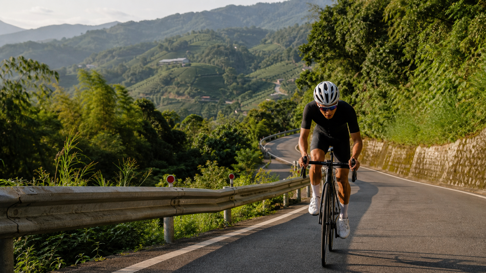
Route Overview: An Underrated Chiayi Hill Training Route
Meishan Wangfengting, Strava segment ID 3350609, is a climb in the Chiayi hill country that is often treated by cyclists as a “warm-up segment” but whose difficulty is frequently underestimated. Let’s lay out the hard data first: the route is 9056.11 meters long, nearly 9.06 km, with an average gradient of 6.4% for the entire route. In Strava’s climb categorization system, it is classified as Category 3. This classification is not arbitrary—Category 3 means that the product of the climb’s length and gradient is sufficient to pose a real challenge to an amateur rider’s cardiovascular system and muscular strength. This is definitely not the “easy rolling hill” that beginners casually call it.
Many people see the name “Wangfengting” and the elevation_m field in the database showing 1054.0 meters, and they instinctively assume this route climbs over a thousand meters. Here, we need to make an honest data correction first: 1054 meters is actually the elevation of the Wangfengting observation platform itself—that is, “how high you are when you reach the finish”—not “how much you climb from start to finish.” Working backward using distance multiplied by average gradient, 9056.11 meters times 6.4% gives a total elevation gain of approximately 580 meters. This figure is the “segment climb” you should use when planning your energy output and pacing. In other words, Wangfengting is high, but you don’t climb there from sea level—the starting point already has a certain elevation base. The actual elevation gain this route asks you to overcome is that roughly 580-meter difference. This confusion between “the location is high” and “how much this segment climbs” is actually quite common in the data labeling of many hill routes in Taiwan. As a route guide, we believe it’s more meaningful to honestly clarify this discrepancy than to blindly accept a daunting number.
From a functional standpoint, this route is best suited as a “beginner-friendly progressive training route” within the Alishan Highway (Provincial Highway 18) system. The distance of just over 9 km won’t leave riders feeling constrained in their energy distribution, while the 6.4% average gradient is enough to make you feel the sustained burning effort. It’s an excellent transitional segment between “suburban gentle climbs” and “heavy-duty long climbs.” For riders preparing to take on the main Alishan Highway route itself (a heavy-duty route that often exceeds 30 km with over 1700 meters of climbing), Wangfengting is an ideal fitness testing ground. For beginners just transitioning from flat terrain to hill country, the length of this route won’t make you question your life choices—it’s a great starting point for building climbing confidence.
Looking further at this route’s position within the broader Chiayi hill training system, you’ll find it plays a bridging role. Meishan Township itself sits in the transition zone between the Chiayi hills and the Alishan mountain range, with terrain gradually rising from flatlands into low mountains before connecting to higher-elevation mountain terrain. Wangfengting sits precisely at a node on this transition zone with excellent views. For cycling teams, this means Wangfengting can be planned as one segment in a “staged test”—ride Wangfengting first, assess your heart rate recovery and leg fatigue, then decide whether to continue challenging higher-elevation segments that day or turn back for a recovery ride. This flexibility is something many long-distance heavy climbs cannot offer.
From a data engineering perspective, this route is also well-suited for short-duration power curve testing. The 9 km distance and 20-to-50-minute completion time (depending on rider level) falls right within the time range many training systems define for “short-interval lactate threshold testing.” If you train long-term with a power meter, Wangfengting can actually serve as a stable FTP (Functional Threshold Power) validation segment. As long as you ride under similar wind and temperature conditions each time, the accumulated data over time can provide a relatively objective fitness progression curve—more representative of real riding conditions than static trainer testing in a gym.
Segment-by-Segment Guide: Pacing Plan from Start to Wangfengting
Breaking the 9.06 km into stages is more effective than grinding through the whole thing.
Stage 1 (0-2 km): Warm-up and gear ratio adaptation period. When you first enter this route from flat or gentle terrain, your body usually hasn’t fully entered climbing mode. It’s recommended to use a medium-to-light gear ratio during this section, keeping your cadence between 85-95 rpm, allowing your heart rate to rise gradually rather than spiking immediately. A common mistake riders make here is seeing the gradient appear and immediately mashing a big gear, exhausting the quadriceps in the first stage and leaving no reserve for later.
Stage 2 (2-5 km): The main climb—the core section with the heaviest gradient. This is typically the section with the most dramatic gradient changes and the greatest cardiovascular load. It’s recommended to keep power or heart rate below but close to the lactate threshold (LT)—the so-called Zone 3 to Zone 4 boundary—keeping the body in a state of “under pressure but not blowing up.” Cadence should drop to 70-85 rpm, alternating between seated and standing positions to avoid excessive fatigue in any single muscle group.
Stage 3 (5-7 km): The middle-to-late section where mental focus最容易鬆懈. Many riders, after passing the halfway point, unconsciously ease off the pace because they know the finish isn’t far—only to be caught off guard when the gradient kicks back up later. In this section, deliberately maintain focus, continuously monitor power or heart rate, and avoid the rhythm disruption caused by “false relaxation.”
Stage 4 (7-9 km): The final climb to the Wangfengting observation platform. The finish is near in this final section. The Wangfengting platform itself sits at an elevation just over 1000 meters, typically accompanied by expansive views and possibly small gradient kickbacks in the terrain. It’s recommended to reserve 15-20% of your energy for this section and adjust your gear ratio flexibly based on road conditions, ensuring you can finish at a steady pace rather than being forced to dismount and walk in the last two kilometers.
It’s worth adding that segmented pacing doesn’t mean mechanically switching rhythm at each milestone—it’s about building “anticipatory awareness.” Knowing what terrain lies ahead prevents your body and mind from being thrown off by sudden gradient changes. A common problem many riders face when first tackling an unfamiliar route isn’t insufficient fitness, but mental unpreparedness: thinking the finish is near, only to have the gradient suddenly kick back up, causing morale to collapse and pacing to fall apart. Through segment planning, you can mentally prepare in advance, treating each section as an independent mini-task rather than being overwhelmed by the entire 9 km route.
Additionally, the timing of switching between seated and standing positions deserves some elaboration. Generally speaking, standing climbs (dancing on the pedals) can provide greater instantaneous power output in short bursts, making them suitable for sections where the gradient suddenly steepens, or for situations where you need to shake off a chaser or sprint to the finish. However, standing climbs place a greater load on the cardiovascular system—if maintained for extended periods, heart rate can spike rapidly, accelerating fatigue accumulation. In contrast, seated climbing produces lower instantaneous power but allows for more stable, efficient sustained output, making it suitable for routes like Wangfengting with moderate average gradients that require long-duration steady output. The recommended strategy is: maintain a seated position most of the time, switching to standing only on sections with obvious gradient kickbacks or when you need a brief acceleration, and keep standing periods to within 10-20 seconds to avoid excessive depletion of muscle glycogen stores.
Gear Ratio and Equipment Recommendations
For a route with a 6.4% average gradient and Category 3 classification, equipment configuration directly affects ride quality and completion time.
| Rider Level | Recommended Chainring | Recommended Cassette | Recommended Minimum Gear Ratio |
|---|---|---|---|
| Beginner/Recreational | 34T (small ring) | 32-34T large cassette | 34/32 or lower |
| Advanced/Semi-club | 34-36T | 28-30T | 34/28 |
| Competitive | 36-39T | 25-28T | 39/25 |
For riders with an average power-to-weight ratio (W/kg) below 3.0, a compact crankset (34/50T) paired with a large cassette (30T or higher) is strongly recommended. This gear configuration keeps cadence in an efficient range and avoids unnecessary stress on the knee joints from overly heavy gearing. Competitive riders with a power-to-weight ratio above 4.0 can consider a standard crankset paired with a tighter cassette to maintain power output efficiency and speed advantage.
Regarding wheelsets, this route’s elevation gain isn’t extreme (approximately 580 meters), so sensitivity to wheelset weight isn’t as critical as on the main Alishan Highway route. However, lightweight wheelsets can still make a noticeable difference in acceleration response and climbing efficiency. If using this route as a regular training segment, training-grade aluminum wheels are entirely sufficient. For pre-race simulations or time trials, consider switching to mid-to-low profile carbon wheels to balance climbing weight with slight aerodynamic benefits.
Tire pressure settings are another frequently overlooked detail. Road surface quality in hill terrain isn’t always perfectly smooth—some sections may have patches or potholes. Setting tire pressure too high reduces rolling resistance but increases the risk of slipping and pinch flats on uneven surfaces; setting it too low increases rolling resistance and slows climbing efficiency. As a general guideline, adjust based on rider weight and tire width: for a rider around 70 kg using 25-28mm tires, front tire pressure can be set around 6.0-6.5 bar, while rear tire pressure, bearing more weight, can be set around 6.5-7.0 bar. Actual values should still be fine-tuned based on personal riding feel.
Frame geometry and cockpit setup are equally worth attention. Climbing sections are no less sensitive to stem length and handlebar height than flat-out sprint sections—an overly aggressive cockpit setup (excessively long stem, too-low handlebars) may yield aerodynamic benefits on flat terrain, but during sustained climbing at 6.4% gradient, it can restrict breathing space and compromise ventilation efficiency. If you find yourself struggling to catch your breath on moderate-gradient routes like Wangfengting, it’s worth checking whether your cockpit setup prioritizes flat-terrain aerodynamics at the expense of climbing comfort and breathing room.
Nutrition and Hydration Strategy
For a 9 km route with a 6.4% average gradient, completion time for the average rider falls between 30 and 55 minutes (depending on individual ability)—a “short-duration, high-intensity” type of effort. Nutrition strategy should be planned to match this exercise duration.
Before the ride: It’s recommended to complete a carbohydrate-containing meal or snack 1-2 hours before departure and ensure your body is well-hydrated—rather than chugging large amounts of water right before getting on the bike, which can cause gastrointestinal discomfort during the ride.
During the ride: Since a single ascent typically takes under an hour, for most riders a single water bottle (500-750ml) is usually sufficient for the entire route’s hydration needs, and additional energy gels or solid food may not be necessary. However, if temperatures are high that day (summer road surface temperatures in the Chiayi hill country are often elevated), or if you plan to continue riding longer distances after completing the Wangfengting climb (such as connecting to other segments of the Alishan Highway system), it’s recommended to carry an extra energy gel or sports bar and consider electrolyte supplements to avoid cramping from electrolyte imbalance caused by excessive sweating.
After the ride: The 15-30 minutes following the climb is the golden window for muscle glycogen recovery. It’s recommended to consume recovery nutrition with a carbohydrate-to-protein ratio of approximately 3:1 to 4:1, paired with continuous small sips of water, to help the body gradually transition from intense exercise back to a steady state.
One additional reminder concerns hydration pacing on the descent back. Many riders, after completing the climb, focus entirely on the satisfaction of “finally done climbing” and overlook the fact that basic hydration should continue during the descent—especially during hot summer hours. While descending doesn’t consume as much energy as climbing, the body’s fluid loss doesn’t stop. It’s recommended to pause briefly at the Wangfengting observation platform, take photos and rest while replenishing fluids and a small amount of carbohydrates before starting the descent. This prevents the situation where, focused entirely on descent handling and forgetting to refuel, you return to flat ground only to discover you’re dehydrated or experiencing low blood sugar.
Weather and Seasonal Recommendations
The Chiayi hill terrain is significantly influenced by monsoons and orographic rainfall. When planning a ride on the Wangfengting route, weather considerations can’t just look at “whether it’s raining down in the plains.”
Spring (March-May): The climate is relatively stable, but be mindful of brief heavy rainfall from spring frontal systems. Afternoon convective cloud systems tend to lift over hill terrain, so it’s recommended to depart in the early morning or morning hours to reduce the chance of encountering rain.
Summer (June-August): This is the most active season for Taiwan’s afternoon thunderstorms. Hill terrain readily triggers convective rainfall, and mountain areas are prone to fog that affects visibility. Departing between 5-7 AM is strongly recommended, completing the ride and descending before afternoon convection develops, to avoid the dual risk of sudden thunderstorms and slippery roads on steeper sections. Summer sunlight is intense, so sun protection and hydration strategies should be correspondingly strengthened.
Autumn (September-November): The northeast monsoon hasn’t fully taken over, and typhoon season is winding down. This is the golden season with the most stable weather year-round, ideal for scheduling long-distance training or challenging the Alishan Highway system routes. As a training segment, Wangfengting carries the lowest weather risk during this period.
Winter (December-February): Under the influence of the northeast monsoon, mountain areas may experience low temperatures, strong winds, and dense fog. Since Wangfengting sits at an elevation just over 1000 meters, temperatures will be noticeably lower than in the plains. It’s recommended to carry a windproof jacket and arm warmers, and to watch for wet, slippery road conditions from condensation.
Common Mistakes and DNF Risk Assessment
Reviewing the common mistakes riders make on this type of short-to-medium gradient route, several typical failure modes can be identified:
Mistake 1: Gearing too heavy, exploding in the early stages. Since the total distance is only 9 km, many riders approach it with a “sprint” mentality, pushing heart rate near maximum in the first 2-3 km, then falling into anaerobic accumulation in the later stages, forced to drastically slow down or even dismount and walk—actually slowing their overall completion time.
Mistake 2: Underestimating the cardiovascular load of a moderate-gradient route. While a Category 3 climb doesn’t require over an hour of sustained effort like the main Alishan Highway route, the 6.4% average gradient means there are virtually no recovery sections of gentler grade throughout, placing substantial demands on sustained output near the anaerobic threshold. Beginners often underestimate this and take on the challenge without adequate preparation.
Mistake 3: Ignoring weather risks, especially summer afternoon thunderstorms. Hill terrain combined with Taiwan’s typical summer convective weather means encountering heavy rainfall and slippery roads on steeper sections in the afternoon is a common scenario for crash accidents. Be sure to adjust your departure time to avoid this risk.
Mistake 4: Poor nutrition timing—deciding whether to eat only mid-ride. Nutrition decisions for this type of short, high-intensity route should be planned before departure, not debated mid-ride. The hesitation itself disrupts rhythm and affects overall performance.
The DNF (Did Not Finish) risk on this route is overall low. The main risks are concentrated in weather (heavy rain and slippery surfaces), equipment failure (flat tires, shifting issues), and heatstroke symptoms under extreme heat. As long as you do basic pre-ride checks and weather assessment, the completion rate should be quite high.
Mistake 5: Neglecting pre-ride drivetrain inspection. On a sustained 6.4% gradient section, if the shifting system hasn’t been properly adjusted beforehand, problems like chain skipping or jamming can easily occur mid-climb—not only disrupting riding rhythm but potentially causing knee injury from sudden gear ratio changes. It’s recommended to check before departure whether the front and rear derailleur cables are loose or whether the chain shows excessive wear. Especially if your bike hasn’t been serviced in a while, a sustained climb like Wangfengting is the perfect testing ground for drivetrain reliability.
Mistake 6: Underestimating the toll of sustained climbing on the core muscles. Many riders focus only on leg strength and cardiovascular capacity while overlooking the stabilizing role of the core muscles (abdominals and lower back) during sustained climbing. Riders with insufficient core strength often experience increased upper-body sway and reduced power transfer efficiency in the later stages of a climb. This is why core training shouldn’t be neglected in your regular strength routine—it directly affects the stability of your power output on medium-to-long climbs like Wangfengting.
Estimated Target Completion Times by Rider Level
The following time estimates are based on route conditions of 6.4% average gradient, approximately 580 meters of total climbing, and 9.06 km total length, referencing common performance ranges of amateur riders on similarly classified climbs. Actual results will vary based on individual fitness, daily wind conditions, and road surface conditions.
| Rider Level | Power-to-Weight Ratio Reference | Estimated Completion Time | Average Speed Reference |
|---|---|---|---|
| Beginner/Recreational | 2.0-2.5 W/kg | 45-55 minutes | Approximately 10-12 km/h |
| General Advanced | 2.5-3.2 W/kg | 32-42 minutes | Approximately 13-17 km/h |
| Experienced/Semi-competitive | 3.2-4.0 W/kg | 24-30 minutes | Approximately 18-22 km/h |
| Competitive/Professional | 4.0 W/kg and above | 18-23 minutes | Approximately 24-30 km/h |
Note: The table above is for training planning reference only and does not represent officially certified results. When actually challenging the route, it’s recommended to first complete it once at moderate intensity to familiarize yourself with the course, then gradually adjust target pacing based on your own data.
It’s worth noting that the time estimates above are calculated under ideal conditions of no wind, moderate temperatures, and dry roads. In actual riding, headwinds, wet surfaces, high temperatures, or the difference between group riding and solo riding can cause completion times to fluctuate by plus or minus 10% to 20%. If you’re tackling this route for the first time, it’s recommended not to set your target at the fastest range in the table. Instead, make completing the ride and recording your power or heart rate data the primary goals. After accumulating two to three ride experiences, you can begin fine-tuning your pacing. In the long term, Wangfengting is well-suited to be incorporated into your periodized training plan as a fixed fitness assessment segment. By repeatedly riding the same route under different fitness states, you’ll more intuitively feel your improvement curve than by simply looking at numbers on a power meter.
Conclusion: Put Wangfengting on Your Training Map
The value of the Wangfengting route lies not in any earth-shattering climbing numbers, but in the fact that it offers a solid, moderate-intensity climbing workout within a relatively accessible 9 km distance. Whether you’re an advanced rider preparing to connect to the main Alishan Highway route or a beginner just starting to explore hill terrain, this road deserves to be taken seriously and understood correctly—its elevation gain is an honest ~580 meters, not the misread 1054 meters. The Wangfengting finish line itself stands high, but the road leading there tests your sustained output capability at a 6.4% gradient. Understand the data, plan your pacing, and this route will give you training returns that far exceed its unassuming length on the map.
Related Reading
- What Wangfengting Sees Beyond the Chianan Plain: A Cycling Reflection on the Meishan Hills
- Taiwan Provincial Highway 3 Meiling Practical Guide: 8.91 km, 618 Meters of Climbing—How to Ride This Tainan Mountain Road
- The Complete Chiayi Waterway Climb Guide: 10.93 km, 6.6% Average Gradient—The Zhuqi Township Trial
- Fanlu Puwei Practical Guide: Data and Tactical Breakdown of the Best Warm-up Segment on the Alishan Highway
4K單車實境) 嘉義 梅山36灣 訓練台 爬坡 輕鬆騎
6 年前
單車 梅山36灣 坡度介紹 路段介紹 空拍 (相關遊記影片,請參考說明或我的頻道喔,歡迎訂閱)
6 年前
梅山36彎 奮起湖 單車挑戰 下集 #公路車
6 年前
台北闊瀨陡坡 騎旅 / 日本單車雜誌編輯車友臨時加入!/ 髮香才是最強的 / feat. 北迴歸線小隊 / 公路車 CT Yeh
6 個月前
大武山後門26%歡樂陡坡!JJSC南台灣單車行Day2 / 被颱風追著跑 / 公路車 / CT Yeh
2 年前
梅山36彎 奮起湖 #公路車 之旅 2400m
6 年前
半日 小台灣 極限單車路線挑戰實錄
7 年前
雨戰! 西進武嶺員工旅遊 加料 各路段大數據分析 | 同事端出5公斤的公路車來挑戰!? EP1
4 年前