Taroko Tianxiang to Xibao Complete Guide: Category 3 Real-World Data Analysis of 7.86 km with 434 m of Climbing
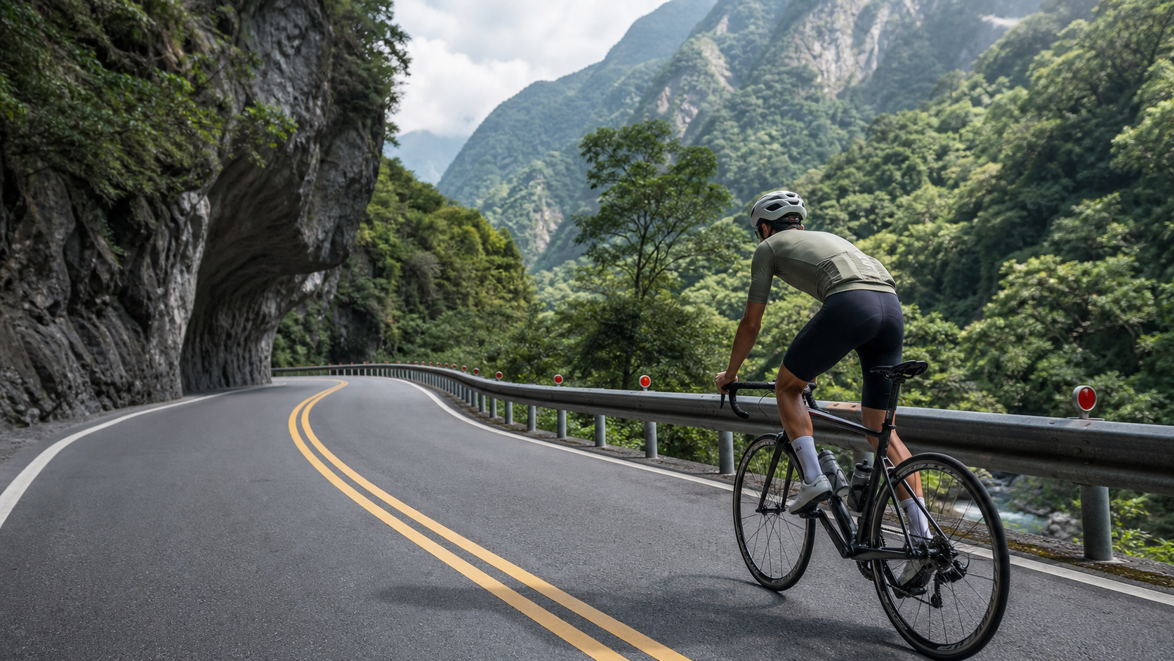
Route Overview: An Efficient Training Segment with 7.86 km and 434 m of Climbing
The Taroko Tianxiang to Xibao segment (Strava segment 10772710) is a classic climb along the Central Cross-Island Highway (Provincial Highway 8) within Taroko National Park, ascending from the canyon terrain into the alpine zone. The official data is very clear:
| Item | Value |
|---|---|
| Distance | 7858.1 meters (7.86 km) |
| Total Ascent | 434.2 meters |
| Average Gradient | 5.5% |
| Strava Category | Category 3 |
| Start Point | Tianxiang (approx. 480 m elevation) |
| End Direction | Xibao (towards Dayuling, Hehuan Mountain) |
Let’s do a quick verification: 7.86 km multiplied by a 5.5% average gradient gives a theoretical ascent of approximately 432 meters, which aligns almost perfectly with the 434.2 meters of total ascent indicated by Strava. This means the gradient distribution on this road is quite “honest”—there are no severe sections hidden behind the average, whether it’s gentle-then-steep or steep-then-gentle. Overall, it’s a climb with a uniform gradient distribution and high predictability. This characteristic is beneficial for training planning: riders can complete the entire segment within a steady power or heart rate zone without needing to reserve extra anaerobic capacity for a sudden steep pitch.
In Strava’s climb categorization system, Category 3 is considered moderately easy (the categories from easy to hard are roughly Cat 4 < Cat 3 < Cat 2 < Cat 1 < HC). Comparing it to other well-known Cat 3 climbs domestically and internationally, the combination of 7.86 km and a 5.5% average gradient places it right at the boundary between a “serious training climb” and a “scenic climb.” Most road cyclists with basic climbing experience can complete it without blowing up, provided their fitness is normal. However, if treated as a warm-up or cool-down segment, it still presents noticeable sustained resistance.
It’s worth noting that the starting point of this climb, Tianxiang, sits at approximately 480 meters above sea level, making it a key transition point where the Taroko Gorge terrain gradually gives way to the alpine zone. Continuing upward from Tianxiang, the road follows the valley of a Liwu River tributary, with the geological landscape on both sides shifting from canyon to forest terrain. Due to the higher elevation, the climate around Xibao is cooler and more humid, and the vegetation is distinctly different from the lower-elevation Taroko Gorge section. For riders preparing for longer goals (such as continuing along the Central Cross-Island Highway towards Dayuling or Hehuan Mountain), the Tianxiang to Xibao segment serves as an excellent starting point for staged training, allowing them to assess their fitness foundation and pacing skills before tackling longer climbs.
Another distinctive feature of this route is its short distance and high density. Accumulating 434 meters of climbing within 7.86 km means riders must sustain output over a relatively short period, with few flat sections for recovery to bring the heart rate down. This differs in training logic from the many long climbs of 20 or 30 kilometers (such as the main routes up Wuling or Hehuan Mountain)—long climbs test endurance and energy management, whereas a mid-distance, moderate-gradient segment like Tianxiang to Xibao is better suited for interval training in the “threshold power” or “lactate threshold heart rate” zone. It’s a segment well worth incorporating into a periodized training plan when preparing for larger climbing events.
Section-by-Section Strategy: Gradient Changes and Pacing Rhythm from Tianxiang
Although the average gradient closely matches the theoretical value, indicating a uniform gradient distribution, it’s still advisable to break the entire segment into several psychological and physiological phases for management during the actual ride, avoiding complacency in rhythm control just because “the numbers look even.” The following breakdown is based on the common gradient distribution logic of the canyon-to-alpine terrain along the Central Cross-Island Highway, provided as a pacing reference for readers. Actual gradient changes should be based on real-time readings from your bike computer and on-site road conditions.
Phase 1 (Start to approximately km 2): Warm-up and Establishing Breathing Rhythm
For the initial section after departing from Tianxiang, it’s recommended not to start with near-maximal power output. The terrain characteristics of the Taroko Gorge section include narrow sightlines and numerous curves, along with possible tunnel sections (see the “National Park Passage Regulations” section below for details). For the first 2 km, keep your heart rate in the moderate aerobic zone (approximately 70-75% of max heart rate) to allow your body and respiratory system to adapt to the sustained climbing rhythm. A seated-dominant, standing-assisted pedaling style is recommended for this section, avoiding excessive depletion of quadriceps glycogen stores early on.
Phase 2 (Approximately km 2 to km 4): Entering the Steady Climb, Establishing Rhythm
In the middle section, you’ll begin to feel sustained and steady gradient pressure—this is the core training zone of the entire route. At this point, it’s recommended to lock your power output at approximately 80-90% of your personal FTP (Functional Threshold Power), or maintain your heart rate in the lactate threshold zone (lower to mid Zone 4). The most important thing in this phase is “maintaining” rather than “attacking”—since the average gradient is 5.5%, it’s a moderate-intensity sustained climb. If you push too hard here, you’ll likely face the double whammy of muscle soreness and excessive cardiovascular load in the latter half.
Phase 3 (Approximately km 4 to km 6): Terrain Transition, Pay Attention to Breathing and Visual Adjustment
As elevation continues to rise, the geological landscape of the Taroko Gorge section gradually transitions—the visual impact of marble cliffs and the Liwu River tributary slowly gives way to more open, increasingly forested mountain terrain. In this phase, it’s recommended to start paying attention to the depth and frequency of your breathing, as the higher elevation, combined with potential temperature changes in the mountains, can cause a slight decrease in breathing efficiency. If you feel short of breath, you can lower your cadence to trade for greater torque output, allowing your breathing rhythm to stabilize again, rather than forcing a high cadence that leaves you gasping for air.
Phase 4 (Approximately km 6 to the finish at Xibao): Final Surge or Steady Completion
The final 1.8 kilometers or so are crucial in determining the quality of the entire ride. Riders with sufficient energy reserves can consider slightly increasing output in this phase to simulate a race-finish surge. However, if you’re already feeling noticeably fatigued, prioritize “completing the route and arriving safely at Xibao” as the primary goal—there’s no need to force a sprint. The Xibao area, with its proximity to Xibao Elementary School and serene forest environment, is an ideal spot for a post-ride rest, refueling, and photo opportunities.
Overall, because of the uniform gradient distribution, the most efficient way to ride this route is to adopt a “negative split” or at least an “even split” strategy, rather than starting fast and fading later. Since the entire segment is only 7.86 km, there’s little room for pacing errors. It’s recommended to set your target power or heart rate zones before departure and monitor them in real-time via your bike computer to ensure consistent pacing throughout.
Gear Ratio and Equipment Recommendations: How to Handle a 5.5% Average Gradient
A 5.5% average gradient isn’t extremely steep for most road cyclists with basic climbing experience, but the sustained 7.86 km length still requires appropriate gear ratios to maintain an efficient cadence. Here are gear ratio recommendations for different bike setups and rider levels:
Crankset and Cassette Configuration Recommendations
- Standard Crankset (53/39T) with Cassette: It’s recommended to have at least an 11-28T or 11-30T cassette to ensure you can maintain a reasonable cadence of 70-85 rpm on steeper sections, avoiding excessive torque load on the knees from too-low cadence.
- Semi-Compact Crankset (52/36T or 50/34T Compact): This is the most common configuration on current road bikes. Paired with an 11-28T to 11-32T cassette, it’s the most comfortable combination for most riders to handle a 5.5% average gradient, allowing for easy maintenance of a steady cadence on climbs.
- Gravel-Style or Larger Cassette Setup: If you have lower fitness levels or want to complete the challenge with minimal effort (for example, riding with family or friends), consider an 11-32T or even larger cassette, sacrificing some cadence efficiency for easier torque requirements.
Other Equipment Recommendations
Beyond gear ratios, the following equipment details are also worth noting:
- Wheelset Choice: Since this route is short with moderate gradients, there’s no need to switch to ultra-light climbing wheels. General training aluminum or mid-range carbon wheelsets will suffice. If you plan to tackle longer sections of the Central Cross-Island Highway (such as continuing to Dayuling or Hehuan Mountain), consider lighter wheels with better climbing efficiency.
- Tire Pressure and Width: The road surface quality along the Taroko Gorge section is generally good, but some sections may have uneven surfaces due to landslide repairs (see the passage regulations section below for details). It’s recommended to use 25-28mm tires and slightly lower tire pressure (compared to riding on completely flat roads) to increase grip and comfort.
- Helmet and Tail Light: This is a mandatory recommendation, not optional—there are tunnel sections along the Taroko route. Your helmet must be equipped with a tail light or reflective accessories, and it’s also recommended to install warning lights on the front and rear of your bike. The detailed reasons will be explained in the dedicated section below.
- Bike Computer and Training Devices: It’s recommended to have a power meter or heart rate monitor, combined with the section-by-section pacing strategy mentioned above, to precisely manage your output throughout the ride, avoiding the common mistake of relying on feel and blowing up early or fading late.
Nutrition, Hydration, and Weather/Season Recommendations
Since the entire segment is only 7.86 km, most riders don’t need to carry a large amount of supplies for a solo attempt, but there are still several practical details worth noting.
Hydration and Energy Intake
A 7.86 km climb with a 5.5% average gradient, ridden at moderate intensity, will take approximately 25 to 40 minutes (depending on rider level and pacing strategy). If you’re doing this route as a standalone training session, it’s recommended to ensure your water bottle is full before departure; gels or energy bars aren’t necessarily needed for a single lap. However, if this segment is part of a longer challenge (for example, riding from the Taroko entrance all the way to Tianxiang, Xibao, or even continuing towards Dayuling), be sure to fully resupply at the Tianxiang rest stop—including water, electrolytes, and carbohydrates—because after Xibao, the elevation continues to rise and resupply points become increasingly scarce.
Weather and Seasonal Considerations
Taroko National Park is located in the mountainous area of Hualien, where weather conditions can change dramatically. Before riding this route, it’s recommended to pay special attention to the following:
- Vertical Temperature Variation: Climbing from Tianxiang (approx. 480 m elevation) to Xibao, the elevation continues to rise and temperatures will drop accordingly. Even if departing in summer, if you plan to continue to higher elevations, it’s still recommended to carry a lightweight windbreaker to cope with potential afternoon temperature drops and showers in the mountains.
- Afternoon Thunderstorms: Mountain terrain is prone to convective rainfall in summer afternoons. It’s recommended to schedule your departure in the morning to avoid afternoon rain and slippery road risks.
- Typhoon and Heavy Rain Season: The Taroko Gorge terrain is susceptible to rockfalls and landslides caused by heavy rain (see the dedicated section below). Extra caution is needed around typhoon season (roughly June to October each year), and be sure to confirm whether the road is closed before riding.
- Winter and Northeast Monsoon: Although winter temperatures in the Hualien mountains aren’t as cold as the northern plains, the northeast monsoon can still bring damp, cold, rainy weather. Additionally, visibility may be reduced due to fog in the mountains, so be sure to enhance reflective and lighting equipment when riding.
Overall, spring (March-May) and autumn (October-November) are typically the seasons with relatively stable weather and lower rainfall probability on the Taroko route, making them the more ideal time windows for this challenge. However, always defer to the real-time weather forecast before departure.
National Park Passage Regulations and Rockfall Risk: Must-Read Before Riding
This is the most important and least skippable section of this entire guide. Along the Central Cross-Island Highway (Provincial Highway 8) in Taroko National Park, especially the Tianxiang to Xibao stretch that transitions from canyon terrain into the alpine zone, there is a long-standing geological risk of rockfalls and landslides. Riders must factor this risk into their planning as the top priority.
Long-Term Impact of Earthquakes and Typhoons on Road Conditions
In recent years, earthquakes (such as the 2024 Hualien earthquake’s landslide impact on the Taroko area) and typhoons with heavy rain have significantly impacted road conditions on the Central Cross-Island Highway and its branches. Some sections may be under long-term closure, single-lane traffic control, or phased repairs. The open/closed status of these geologically sensitive sections adjusts dynamically based on construction progress and weather conditions. This article cannot, and should not, assert whether the current road conditions are fully open.
Verification Steps Required Before Riding
Before planning this challenge, be sure to confirm the latest road conditions through the following channels:
- Taroko National Park Headquarters official website and announcements—check whether any sections within the park are closed, require reservations, or have traffic diversion controls.
- Highway Bureau Hualien Maintenance Office (or relevant maintenance units) real-time road condition announcements—confirm whether Provincial Highway 8 (Central Cross-Island Highway) is closed or under time-based controls due to landslides or construction.
- Ministry of Transportation and Communications Highway Bureau’s Provincial Highway Real-Time Traffic Information System—check real-time information on road closures, landslides, and construction.
- On-site Controls and Signage—even if pre-departure checks show the road is open, there may still be temporary warnings or controls due to sudden landslides or rockfalls. Always obey on-site traffic direction and signage.
Key reminder: The geological characteristics of the Taroko Gorge section mean that “open today” doesn’t guarantee “open tomorrow.” Road conditions can change extremely rapidly after heavy rain or earthquakes. It’s recommended to re-confirm the latest announcements the day before, or even on the morning of, your ride.
Tunnel Section Safety Reminders
There are multiple tunnels along the Taroko section of the Central Cross-Island Highway, and the Tianxiang to Xibao segment and its vicinity may also include tunnel sections. Lighting conditions inside tunnels differ drastically from outside, and with limited space inside tunnels and potential motor vehicle traffic, please pay close attention when riding through tunnels:
- Helmet tail light and reflective accessories on the bike are essential equipment, not optional—visibility is low inside tunnels, and the risk is extremely high if approaching vehicles can’t spot you early enough.
- Front light: Even when riding during the day, it’s recommended to turn on your front light to increase visibility inside tunnels.
- Ride on the right and avoid weaving: If the road surface inside a tunnel is uneven or slippery, maintain a steady, straight line and avoid sudden lane changes.
- Reduce speed when passing through tunnels: Especially if descending through consecutive tunnels, be sure to control your speed to avoid being unable to react due to visual adaptation lag.
Awareness of Rockfall and Landslide Risks
Even when official announcements indicate the road is open, the Taroko Gorge section remains a geologically sensitive area. Riders are advised to:
- Avoid riding this section within 24 to 48 hours after heavy rain has just ended, as the risk of loose soil and rocks on slopes is highest during this period.
- If you hear unusual sounds from the rock face or see traces of scattered rockfalls during your ride, stay alert, and turn back or seek help if necessary.
- Avoid attempting this route under severe weather conditions such as strong winds or heavy rain.
The Taroko people have inhabited this canyon territory for generations. The canyon’s geological landscape is magnificent, but precisely because of the unique nature of the marble geology, slope stability is relatively fragile. This is the fundamental reason why official traffic controls are dynamically adjusted based on weather and geological conditions. Respecting official announcements and riding within your limits are the most important prerequisites for completing this challenge.
Common Mistakes and DNF Risks
Even on a segment of only 7.86 km, there are several common pacing errors and preparation oversights that can lead to riders failing to complete the challenge (DNF, Did Not Finish) or having a significantly diminished riding experience. Here are some common situations encountered in practice:
Mistake 1: Pacing Too Hard Early, Running Out of Energy Later
Because the overall average gradient is only 5.5%, many riders underestimate the sustained load of this segment and start with near-sprint power output. As a result, they experience a noticeable slowdown around km 4 to km 6 (the third phase in the section-by-section strategy above), or even need to stop to catch their breath. Since the gradient distribution is relatively uniform, it’s recommended to start at a sustainable moderate intensity rather than expecting to “push hard first and see what happens.”
Mistake 2: Ignoring Equipment Preparation for Tunnel Sections
Failing to check whether the route includes tunnel sections before heading out, or knowing there are tunnels but not bringing a tail light or turning on the front light, is a common yet highly risky oversight. It’s recommended that regardless of whether you’re certain you’ll pass through tunnels, you should develop the habit of carrying a tail light and reflective accessories whenever challenging the Taroko Gorge section.
Mistake 3: Departing Without Verifying the Latest Road Conditions
As emphasized in the previous section, the geological sensitivity of the Taroko section means road conditions can change at any time. There have been riders who, without checking announcements in advance, arrived on-site only to find the road closed or under traffic diversion controls, forcing their trip to be cancelled or rerouted. This type of situation can be entirely avoided through online verification before departure.
Mistake 4: Insufficient Gear Ratios, Leading to Low Cadence and Knee Strain
Some riders, especially road cycling beginners who rarely engage in climbing training, may still have gear configurations with a standard crankset paired with a smaller cassette (for example, 11-25T). Under the sustained climb of a 5.5% average gradient, they’re forced to grind at excessively low cadences, placing unnecessary strain on the knee joints over time. It’s recommended to adjust your cassette configuration according to your fitness level, following the suggestions in the gear ratio section above.
Mistake 5: Insufficient Hydration or Poor Timing of Refueling
Although a single 7.86 km lap doesn’t require much in the way of supplies, if this is part of a longer challenge (for example, riding from the Taroko entrance all the way to Xibao, or even further towards Dayuling), many riders underestimate the refueling needs of the subsequent sections. Departing from the Tianxiang rest stop without a full resupply can lead to a shortage of supplies after Xibao.
Mistake 6: Underestimating Weather Changes, Not Bringing Warm or Rain Gear
Afternoon thunderstorms in the mountains and the temperature drop associated with elevation gain are variables that many flatland riders tend to overlook. It’s recommended that even when departing in summer, as long as your itinerary includes high-elevation sections above Tianxiang, you should carry a lightweight rain/wind jacket to cope with sudden weather changes.
Target Time Reference Table for Different Rider Levels
The following time table is based on the route conditions of 7.86 km, 434.2 meters of ascent, and a 5.5% average gradient, and references typical training intensity conversions for Category 3 climbs. It provides target time reference ranges. Actual completion times will vary depending on fitness level, weather conditions on the day, equipment, and pacing strategy. This table is intended solely as a reference baseline for planning training goals and is not an officially certified classification standard.
| Rider Level | Estimated Completion Time | Average Power Reference (W/kg, estimated for 70kg body weight) | Pacing Strategy Recommendation |
|---|---|---|---|
| Pro/Semi-Pro Level | Approximately 18-22 minutes | 4.5W/kg and above | High-intensity output throughout; can be treated as an interval training unit |
| Advanced Experienced Rider | Approximately 22-28 minutes | 3.5-4.5W/kg | Steady threshold intensity; even split strategy |
| General Experienced Rider | Approximately 28-38 minutes | 2.5-3.5W/kg | Moderate aerobic intensity; conservative start, adjust based on energy in the latter half |
| Weekend Recreational Rider | Approximately 38-50 minutes | 2.0-2.5W/kg | All-aerobic pacing; primary goal is completion |
| Beginner/Family Leisure | Approximately 50 minutes or more | 1.5-2.0W/kg | No need to chase speed; take ample rest breaks and complete at a leisurely pace |
How to Use This Table: The power reference values above are rough estimates. For more precise target setting, you should convert based on your personal FTP test results (it’s recommended to use 75-95% of FTP as the sustained climbing output zone). If you haven’t done a power test yet, it’s recommended to use the Rating of Perceived Exertion (RPE, on a 10-point scale) as an alternative reference—aim to keep the entire ride at RPE 6 to 8 (moderate to high intensity but still able to hold a conversation), avoiding explosive outputs above RPE 9 that could lead to fading or cramping in the latter half.
Regardless of which level you fall into, the most valuable training significance of this route lies in the fact that it’s an excellent short-distance indicator for assessing your “sustained climbing output capability.” The short distance, moderate and uniformly distributed gradient mean that differences in completion time primarily come from fitness and pacing strategy, rather than the technical difficulty of the route itself or weather uncertainty—this is also why many riders planning to tackle longer Central Cross-Island Highway sections (such as Dayuling or Hehuan Mountain) choose the Tianxiang to Xibao segment as their benchmark training route.
Final Reminder: Whether you’re approaching this route with training goals or a recreational mindset, please prioritize the official passage announcements described in Section 5 above. No matter how ideal your pacing plan is, it should be built on the premise of confirmed road safety and complete equipment. The magnificent scenery of the Taroko Gorge is worth appreciating with your full attention, and it’s also worth treating with a cautious attitude.
Related Reading
- Millions of Years and an Instant in the Gorge: Riding Through Taroko Tianxiang to Xibao, Understanding the Weight of a Road
- Eastern Taiwan Hualien Taroko Route: A High-Difficulty Riding Guide Through the Spectacular Canyon Landscape
- Taroko Gorge Cycling Safety Guide: Riding Tips for Crossing the Marble Canyon
- Taroko Gorge Cycling Journey: The Marble Corridor from Xincheng to Tianxiang
台灣登山王之路 KOM 全程參賽4K臨空錄影 PART1 穿越峽谷地形! #東進武嶺 太魯閣 / 燕子口 / 天祥 / 西寶 PART1 (公路車 / CT Yeh)
3 年前
新竹羅平 x 天湖部落 大禹嶺級變態陡坡! 4K超高畫質 空拍 | 公路車
5 年前
台北闊瀨陡坡 騎旅 / 日本單車雜誌編輯車友臨時加入!/ 髮香才是最強的 / feat. 北迴歸線小隊 / 公路車 CT Yeh
6 個月前
#東進武嶺 全程實況錄影 5小時半 #夏季KOM #太魯閣 Taiwan KOM Challenge Reality Video Taroko scenery
7 年前
嘉義大埔、阿婆灣挑戰賽,美到以為在日本!ft. 環騎5 Cool 西拉雅188 / 公路車 / CT Yeh
7 個月前
大禹嶺 到 武嶺牌樓 全程前後實況錄影 | 北進武嶺 | 東進武嶺 | KOM | 訓練台 | 坡度分析 | Taiwan KOM Last 10 km HARD | 公路車
6 年前
爬坡ITT實境)台中 魔王 松鼠坡 首航 6:12 大肚山 大三元 科福路
8 年前
那瑪夏x茶山 阿里山系深山單車行 Day2 累積爬升6000M | 🥶超陡連續下坡 整路看隊友刷 | 爬升一座西進武嶺 | JJSC | 公路車 | CT Yeh
3 年前