Bike Computer Navigation Showdown: Garmin Edge vs Wahoo ELEMNT vs Hammerhead Karoo vs Bryton
文章導覽
Bike Computer Navigation Showdown: Garmin Edge vs Wahoo ELEMNT vs Hammerhead Karoo vs Bryton
Navigation on a modern bike computer is no longer just “follow the arrow.” From real-time route planning and climb previews to turn-by-turn intersection prompts, every brand has invested heavily in the navigation experience. This article takes a deep dive into how four major brands stack up on navigation.
Navigation Positioning of the Four Brands
Garmin Edge Series
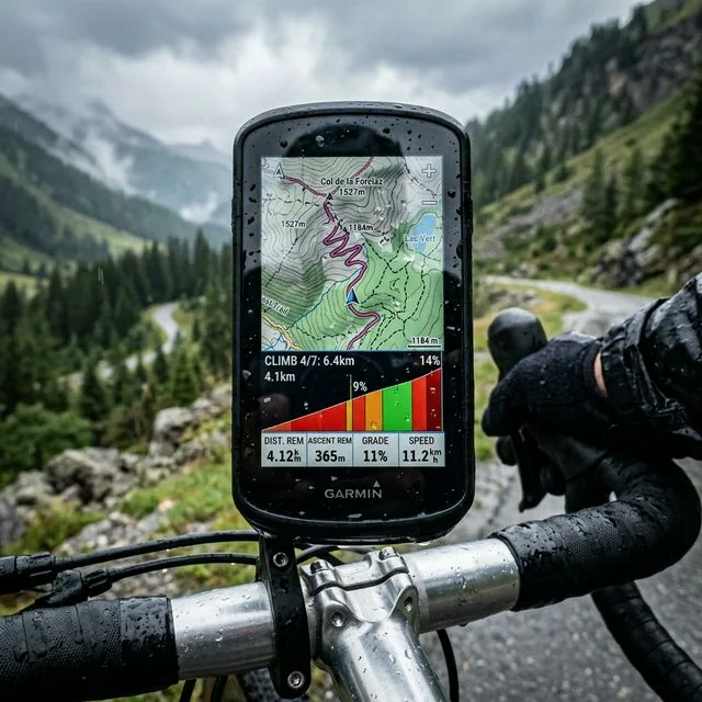
As the leader in bike computers, Garmin invests the most resources into navigation. The latest Edge 1050 even comes with a color touchscreen and preloaded global maps, bringing the navigation experience close to smartphone level.
Flagship navigation models:
- Edge 1050: Top-tier flagship with a large 7-inch screen and full-color maps
- Edge 840: Mid-tier flagship with dual touch + button controls
- Edge 540: Button-only operation, with features similar to the 840
- Edge 140 Plus: Entry-level, with basic navigation features
Wahoo ELEMNT Series
Wahoo’s navigation philosophy is “simple and intuitive” — rather than chasing the most features, it focuses on making every feature easy to use.
Flagship navigation models:
- ELEMNT ACE: The newest flagship, with a large color screen
- ELEMNT ROAM V2: Mid-tier, with a color screen
- ELEMNT BOLT V2: Compact model, with a color screen
Hammerhead Karoo
Karoo has been the most talked-about newcomer brand in recent years, running on Android with a highly modern interface design.
Flagship navigation model:
- Karoo 3: The newest model, with a high-resolution color touchscreen
Bryton Rider Series
Bryton is a Taiwanese brand with solid market share in Asia, known for excellent value for money.
Flagship navigation models:
- Rider S510: Flagship model with a color touchscreen
- Rider 750: Mid-tier, with a touchscreen
- Rider 420: Entry-level, with basic navigation
Map Quality Comparison
Map Source and Resolution
| Computer | Map Source | Color Map | Preloaded Maps | Update Frequency |
|---|---|---|---|---|
| Garmin Edge 1050 | Garmin Maps | Full color | Global | Quarterly |
| Garmin Edge 840 | Garmin Maps | Full color | Global | Quarterly |
| Wahoo ACE | Wahoo Maps | Full color | Global | Irregular |
| Wahoo ROAM V2 | Wahoo Maps | Full color | Global | Irregular |
| Karoo 3 | OpenStreetMap | Full color | Global | Real-time |
| Bryton S510 | OpenStreetMap | Full color | Regional | Irregular |
Map detail ranking:
- Garmin Edge 1050: The most detailed maps, including road names, points of interest, and terrain shading
- Karoo 3: Based on OSM but with extremely high rendering quality, and can be updated in real time
- Wahoo ACE: Clean and simple maps, with key information easy to read at a glance
- Bryton S510: Maps are serviceable, but detail falls short of the top three
Taiwan Map Localization
For navigation in Taiwan, how well the map is localized matters a lot:
Garmin: Has the most complete Taiwan maps, supporting Chinese road names and points-of-interest search. After all, Garmin has spent many years cultivating its navigation product line in Taiwan, so its map database is very mature.
Karoo 3: Uses OpenStreetMap. Taiwan’s OSM community is quite active, so the map data is fairly complete as well. However, its Chinese search function is not as intuitive as Garmin’s.
Wahoo: Taiwan map coverage is complete, but points-of-interest and search functions are relatively basic.
Bryton: As a Taiwanese brand, its Taiwan map localization is solid, with full Chinese-language support.
Route Planning Features
On-Device Real-Time Planning
Garmin Edge 1050/840:
- Supports searching a destination and planning a route directly on the device
- Lets you choose route preferences such as “shortest distance,” “least climbing,” or “most popular”
- Uses Trendline popularity routing data to select roads most used by cyclists
- Supports multi-point route planning
This is one of Garmin’s biggest advantages — even without planning a route beforehand, you can search for a destination directly on the device mid-ride and start navigating.
Karoo 3:
- Supports on-device route planning
- Can search addresses and points of interest
- Map touch operation is extremely smooth (thanks to Android’s touch optimization)
- However, route quality doesn’t match Garmin’s Trendline data
Wahoo:
- ELEMNT ACE supports basic destination navigation
- Route planning mainly relies on the phone app or third-party apps (Komoot, RideWithGPS)
- The “Take Me To” feature quickly plans a route to a specified location
Bryton:
- On-device real-time route planning is fairly basic
- Mainly relies on the phone app or imported GPX files
Importing Routes from Apps/Websites
All four computers support importing routes from third-party platforms, though convenience varies:
| Feature | Garmin | Wahoo | Karoo | Bryton |
|---|---|---|---|---|
| Strava route sync | ✓ | ✓ | ✓ | ✓ |
| Komoot sync | ✓ | ✓ | ✓ | ✗ |
| RideWithGPS sync | ✓ | ✓ | ✓ | ✗ |
| GPX import | ✓ | ✓ | ✓ | ✓ |
| Wireless sync speed | Fast | Fast | Fastest | Medium |
Karoo 3 performs best in route sync speed, since it can download routes and maps quickly via Wi-Fi.
Navigation Experience Comparison
Turn-by-Turn Prompts
The most critical part of the navigation experience is the turn prompt. When riding at speed, a cyclist doesn’t have much time to stare at the screen, so clear turn prompts are essential.
Garmin:
- Shows turn prompts 100–200 meters ahead
- The screen automatically zooms in on intersection details
- Paired with an audible beep
- Complex intersections show lane guidance
Wahoo:
- LED light bars at the top and bottom of the screen flash to indicate turn direction
- The left LED lights up for a left turn, the right LED for a right turn
- This design is especially useful in bright sunlight, more noticeable than screen prompts alone
- Paired with an audible beep
Karoo 3:
- Large screen shows clear turn icons
- Voice navigation prompts (via Bluetooth headphones)
- Zoomed-in intersection view
- Countdown of remaining distance
Bryton:
- Basic turn arrow prompts
- Audible beep
- Prompt timing and clarity are adequate, nothing exceptional
Handling Route Deviation
Taking a wrong turn is common, so how a computer handles going off-route matters:
- Garmin: Automatically recalculates the route (requires map support), completing recalculation in about 5–10 seconds after detecting a deviation
- Wahoo: Alerts you that you’re off-route and shows return guidance; ACE supports automatic rerouting
- Karoo 3: Automatically recalculates the route, quickly and accurately
- Bryton: Alerts you that you’re off-route, but requires manually returning to the original route
Climb Preview (ClimbPro-type Features)
Garmin ClimbPro:
This is one of Garmin’s most popular navigation aids. When a route includes a climb, ClimbPro automatically detects it and displays:
- Climb elevation profile
- Your current position within the climb
- Remaining distance and elevation gain
- Grade of each segment (color-coded)
- Estimated remaining time
Wahoo: The ELEMNT ACE and ROAM V2 also offer a similar climb page, showing the elevation profile and remaining details.
Karoo 3: Offers a Summit Free feature, similar to ClimbPro, showing real-time climb progress and grade analysis. Karoo’s advantage is high rendering quality — the gradient color display is very intuitive.
Bryton: Higher-end models provide basic climb information, but detail falls short of the top three.
Screen and Operation Experience
Screen Quality
| Computer | Screen Size | Resolution | Touch | Sunlight Visibility |
|---|---|---|---|---|
| Edge 1050 | 3.5" | 282x470 | Touch | ★★★★☆ |
| Edge 840 | 2.6" | 246x322 | Touch + buttons | ★★★★★ |
| Wahoo ACE | 3.1" | High resolution | Touch | ★★★★☆ |
| Karoo 3 | 3.2" | 400x640 | Touch | ★★★★☆ |
| Bryton S510 | 2.4" | 240x320 | Touch | ★★★★☆ |
Karoo 3 has the highest screen resolution, delivering the finest map display. The Garmin Edge 840’s transflective screen has the best readability in strong sunlight.
Operation Method
Ease of operation while navigating directly affects riding safety:
- Touch-only (Edge 1050, Karoo 3, Wahoo ACE): Intuitive, but difficult to operate with gloves on
- Touch + buttons (Edge 840): Most flexible, operable in any condition
- Buttons only (Edge 540, ELEMNT BOLT): Glove-friendly, but map zooming is less convenient
Battery Life (with Navigation Mode On)
Because navigation requires continuous map rendering and route calculation, battery drain is much faster than in simple recording mode:
| Computer | Normal Recording Mode | Navigation Mode On | Solar Charging |
|---|---|---|---|
| Edge 1050 | About 20 hours | About 12 hours | No |
| Edge 840 Solar | About 26 hours | About 16 hours | Yes |
| Wahoo ACE | About 24 hours | About 14 hours | No |
| Karoo 3 | About 12 hours | About 8 hours | No |
| Bryton S510 | About 28 hours | About 18 hours | No |
Karoo 3’s battery life is its biggest weakness — 8 hours of navigation runtime may not be enough for a single-day long-distance ride. Bryton and the Garmin Edge 840 Solar perform best on battery life.
Buying Recommendations
If Navigation Is Your Top Priority
Most complete navigation experience → Garmin Edge 1050
- Real-time route planning, Trendline popular routes, ClimbPro, and the richest Taiwan map data
- Great for cyclists who frequently explore new routes
Best visual experience → Hammerhead Karoo 3
- Highest screen resolution, smoothest touch operation, real-time map updates
- Great for cyclists who value interface design and user experience
Most intuitive turn prompts → Wahoo ELEMNT ACE
- LED light bar turn prompts, clean interface, excellent third-party app integration
- Great for cyclists who don’t want to spend time learning complex features
Best value for money → Bryton Rider S510
- Complete navigation features, extremely long battery life, affordable price
- Great for cyclists on a budget who still need navigation
Pairing Recommendations
Whichever computer you choose, the following setup tips will help you get the best navigation experience:
- Plan your route ahead of time: Even if your computer supports real-time planning, planning on a computer or phone beforehand is still the best approach
- Download offline maps: Make sure the maps for your riding area have been downloaded to the computer
- Get familiar with turn prompts: Test the navigation feature on a familiar route first to learn its timing and style
- Backup navigation: Install Google Maps or Komoot on your phone as a backup
- Charging management: Bring a power bank on long rides — most computers support charge-while-in-use
Bike computer navigation features are evolving rapidly. Choose the computer that best fits your needs, and explore new routes with confidence on every ride.