Nanheng Highway: Taiwan's Wildest Cross-Island Highway
The Nanheng Highway (Provincial Highway 20) runs from Tainan City through Jiaxian and Taoyuan in Kaohsiung, crosses the pass over the Central Mountain Range (the Da Guanshan Tunnel, at an elevation of 2,722 meters), and arrives at Haiduan and Guanshan in Taitung. At roughly 204 kilometers long, it was the last of Taiwan's three cross-island highways to open to traffic, and remains the most raw and untamed. After more than a decade of repair work following Typhoon Morakot in 2009, the Nanheng Highway has finally reopened along its full length in recent years, allowing cyclists to once again experience this legendary route.
Route Overview
Suggested starting point: Jiaxian (Jiaxian District, Kaohsiung City, elevation approx. 250 meters)
Ending point: Guanshan (Guanshan Township, Taitung County, elevation approx. 300 meters)
Core segment distance: approx. 150 km (Jiaxian to Guanshan)
Total elevation gain: approx. 3,500 meters
Highest point: Da Guanshan Tunnel/Pass (elevation 2,722 meters)
Difficulty rating: ★★★★★ (Extreme)
Suggested duration: 2-3 days
Western Section: Jiaxian to the Pass
Jiaxian to Baolai (approx. 30 km)
Starting from Jiaxian, the route follows the Laonong River valley south to Baolai. The gradient on this stretch is gentle, and the scenery along the way is a beautiful river valley landscape. Baolai is famous for its hot springs, and if time allows, you can soak and relax your muscles after finishing this section. Baolai has several shops and eateries, making it the last well-stocked supply point on the western section — be sure to fully restock here.
Baolai to Taoyuan (approx. 15 km)
From Baolai to Taoyuan, you begin entering traditional Bunun territory. The gradient gradually increases, and along the way you’ll see the tribe’s stone-slab houses and traditional totems. There are small shops near the Taoyuan District Office where you can make a final supply check.
Taoyuan to Meishankou (approx. 25 km)
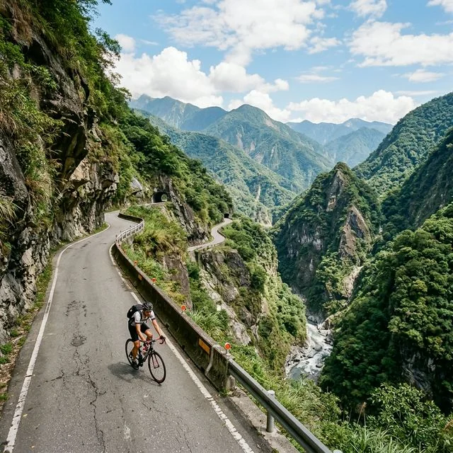
This stretch is one of the most spectacular sections of the western Nanheng. Passing through Qinhe and Fuxing, the route crosses numerous tunnels and covered galleries. The scars of Typhoon Morakot are still clearly visible along this section — massive landslides, rerouted rivers, and rebuilt bridges. These sights are a reminder of nature’s power. Road quality varies due to ongoing repair work, and some sections may still be temporary detours.
Meishankou to the Pass (approx. 35 km, approx. 1,800 m elevation gain)
This is the toughest yet most magnificent section of the Nanheng Highway. From Meishankou (elevation approx. 900 meters) to the pass (elevation 2,722 meters), you climb nearly 1,800 meters over 35 kilometers, with an average gradient exceeding 5%. Along the way you’ll pass Tianchi (Sky Lake, elevation 2,280 meters), a beautiful alpine lake said to be the legendary entrance to the “Evergreen Shrine.” Continuing upward, you’ll pass through Kuaigu, home to magnificent giant red cypress and Taiwan cypress trees. Finally, you’ll reach the mouth of the Da Guanshan Tunnel — the pass itself, at an elevation of 2,722 meters. On a clear day, standing here offers a magnificent view of Yushan (Jade Mountain) and Guanshanling in the distance.
Eastern Section: The Pass to Guanshan
The Pass to Xiangyang (approx. 10 km, downhill)
After passing through the Da Guanshan Tunnel, you enter Taitung County. This downhill stretch is extremely steep, with an average gradient exceeding 6%, and features numerous hairpin turns requiring frequent braking. The road surface may have gravel and slippery fallen leaves, so be sure to control your speed. Xiangyang National Forest Recreation Area is nearby, and if daylight is fading, you might consider camping here for the night.
Xiangyang to Lidao (approx. 20 km)
Continuing to descend from Xiangyang, you pass through Jiabaoshan and Motian before arriving at the Lidao tribal village. Lidao is the most important Bunun village on the eastern section, with guesthouses and simple dining options. From Lidao you can gaze out at the beautiful alpine longitudinal valley scenery — a breathtaking view that will make you forget the day’s fatigue.
Lidao to Guanshan (approx. 45 km, mostly downhill)
From Lidao through Haiduan to Guanshan is a long but comfortable descent. Along the way you’ll pass the Xinwulyu River valley, where towering cliffs rise on both sides of the gorge. Passing through Wulu, you can feel the hot spring steam rising from the river valley — the grandeur of Wulu Gorge rivals that of Taroko Gorge. Finally, you’ll arrive in Guanshan, back on the flat plains of the East Rift Valley. Enjoying a bowl of local Guanshan rice lunch box is the perfect way to conclude this Nanheng journey.
Traffic Control Information
Portions of the Nanheng Highway are currently still subject to traffic control. The section from Meishankou to Xiangyang is typically open during specific time windows each day, and may be temporarily closed due to weather conditions. Be sure to check the latest traffic control announcements before setting out. It’s recommended to check the Highway Bureau’s website or call the Nanheng control station. Bicycles are generally classified as slow-moving vehicles, so check whether the control hours apply to cyclists.
Safety Reminders
The Nanheng Highway is far more remote than the Central Cross-Island Highway, and mobile phone signal is completely absent on some sections. It’s recommended to bring offline maps, a backup power bank, and a first-aid kit. Weather at high altitude can change extremely quickly, with fog or rain common in the afternoons, sometimes reducing visibility to less than 10 meters. Wearing brightly colored cycling gear and using high-brightness bike lights are basic safety measures. If possible, riding with a partner is much safer than tackling this challenge alone.
Related Reading
大武山20%魔王陡坡【JJSC南台灣遊騎Day2】!屁股真的要裂開了...凡士林抹滿也沒用?神秘金教堂還有超便宜夜市
3 個月前
#北橫 + #北進武嶺 最硬的員工旅遊 EP1 | #公路車 #拉拉山 | 明池 | 武嶺 | 武陵農場 | 雲海 | Taiwan Cycling Route Wulin
6 年前
嘉義大埔、阿婆灣挑戰賽,美到以為在日本!ft. 環騎5 Cool 西拉雅188 / 公路車 / CT Yeh
7 個月前
半日 小台灣 極限單車路線挑戰實錄
7 年前
大武山後門26%歡樂陡坡!JJSC南台灣單車行Day2 / 被颱風追著跑 / 公路車 / CT Yeh
2 年前
微東進 太魯閣 蘇花 單車兩日遊 ! 颱風過後路況超刺激 行程大亂 | 最狂的鹹酥雞訂單 | CT Yeh | 4K 高畫質空拍絕景!
4 年前
爬坡ITT實境)台中 魔王 松鼠坡 首航 6:12 大肚山 大三元 科福路
8 年前
台北闊瀨陡坡 騎旅 / 日本單車雜誌編輯車友臨時加入!/ 髮香才是最強的 / feat. 北迴歸線小隊 / 公路車 CT Yeh
6 個月前