Introduction
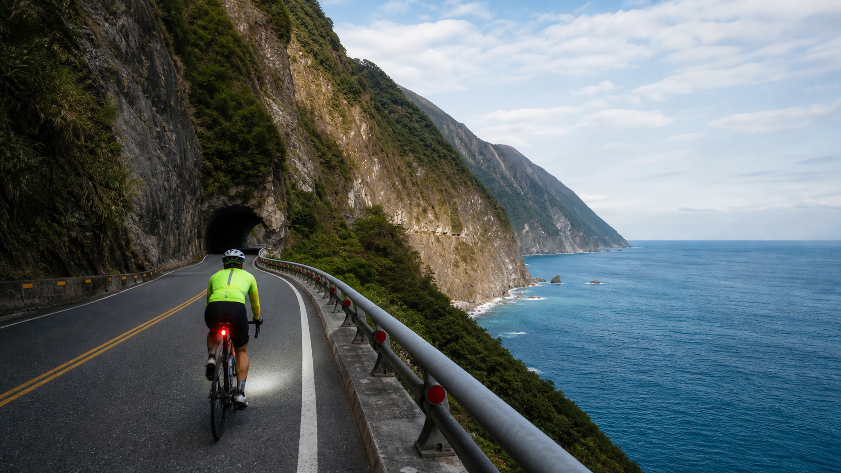
The Suhua Highway, Provincial Highway 9 from Su’ao to the southern end of Hualien, stretches approximately 118 kilometers. This road is etched into the memory of every island-circumnavigating cyclist, not only for its magnificence—sea cliffs, the deep blue Pacific, and tunnels carved into sheer rock faces—but also because it is the first true test of the entire journey. Only after riding through Suhua can you truly say you have entered the heart of the island tour.
The Terrain Features of Suhua Highway
The Suhua Highway is carved along the coastal cliffs on the easternmost side of the Central Mountain Range. For most of its length, the cliffs drop straight into the Pacific Ocean, with the road suspended in between, just wide enough for two vehicles to pass.
Main terrain sections:
| Section | Distance | Features | Difficulty |
|---|---|---|---|
| Su’ao → Dong’ao | Approx. 22 km | Entering mountainous area, climbing begins | Medium |
| Dong’ao → Nan’ao | Approx. 14 km | Relatively flat, multiple tunnels | Low |
| Nan’ao → Heping | Approx. 40 km | The most spectacular sea-cliff section, old tunnel clusters | High |
| Heping → Chongde | Approx. 30 km | Entering the Suhua Improvement section, gentler gradients | Medium |
| Chongde → Hualien | Approx. 12 km | Flat road, entering Hualien city | Low |
Suhua Improvement vs. Old Suhua: Choices for Cyclists
In recent years, the “Suhua Improvement” (Provincial Highway 9 Suhua Highway Mountain Area Improvement Project) has gradually opened to traffic, providing a safer driving environment. However, many tunnels and freeway-style sections of the Suhua Improvement are not open to bicycles.
Options for cyclists:
- Ride the Old Suhua: The original Provincial Highway 9, retaining many old tunnels with spectacular scenery, but some sections have steep gradients and tunnels that are long and dark
- Ride parts of the Suhua Improvement: Check the latest announcements from the Directorate General of Highways to confirm which sections are open to bicycles; advance application is usually required
- Take the train to skip sections: Many first-time island tourers choose to take the train from Su’ao or Hualien. This is entirely reasonable and does not diminish the meaning of the tour
Safe Riding Through Tunnels
The tunnels of Suhua Highway are the sections requiring the most caution. Here are key points to note:
- Front and rear lights must be on at all times: Visibility inside tunnels is extremely low; even during the day, a flashing red rear light is needed
- Reflective vest or hi-vis clothing: Greatly increases visibility; it is recommended to put it on before entering Suhua
- Do not stop inside tunnels: After confirming no vehicles are approaching, pass through quickly; never stop midway through a tunnel
- Observe traffic flow before long tunnels: Wait for a gap at the tunnel entrance, and only enter after confirming no vehicles are approaching from either direction
- Maintain a straight riding line: Tunnel floors may have standing water or gravel; keep a steady course
- Keep your ears sharp: If wearing earphones, they must be removed before entering a tunnel
Supply Points and Mileage Planning
Supply points are scarce along Suhua Highway, making it one of the sections with the longest gaps between resupply stops on the entire island tour:
- Dong’ao: Has convenience stores where you can replenish food and water; be sure to stock up fully here
- Nan’ao: Has a gas station and small shops where you can replenish energy bars or drinks
- Heping: A cement factory industrial area with a few residential shops; unreliable
- Chongde: Near Hualien, supply points begin to reappear
It is recommended to carry at least 1.5 liters of water and 600–800 kcal of food from Nan’ao to avoid hypoglycemia before reaching Heping.
Weather and Time Planning
- Departure time: Depart from Su’ao no later than 7:00 AM, aiming to arrive in Hualien before 3:00 PM to avoid the afternoon strong winds and rockfall risk
- Do not ride in rain: The risk of rockfall on Suhua Highway rises significantly in rain or after typhoons; if in doubt, choose the train
- Weekend caution: On holidays, cycling groups concentrate and traffic in tunnel sections increases, requiring extra care
- Summer afternoon thunderstorms: If the forecast shows heavy afternoon thunderstorms, consider departing a day earlier or staying an extra night in Nan’ao
Practical Advice
- Inform family and friends of your itinerary: Signal on the Suhua section is intermittent; let family and friends know your expected arrival time in Hualien before departing
- Carry your ID at all times: Some rerouted sections have checkpoints where you must present your ID
- Don’t push yourself; take the train if tired: The TRA Tzu-Chiang Limited Express can carry bicycles (with a wheel bag, limited spaces); from Su’ao New Station to Hualien takes about 1.5 hours
- Solo riders should be extra cautious: If riding alone, team up with other cyclists when passing through tunnel sections
Conclusion
The grandeur of Suhua Highway cannot be fully described in words. That ethereal feeling of riding along the edge of the Pacific is one of the most precious memories of the island tour. With adequate preparation and respect for the road conditions, this stretch is not a forbidden zone but the most worthy cycling challenge in Taiwan. Ride through Suhua, and you have truly circled Taiwan.
Related Reading
- Suhua Highway Cycling Guide: A Complete Guide to Scenery, Safety, and Route Planning
- A Full Record of Riding Suhua Highway: Taiwan’s Most Stunning Coastal Road Experience
- The Majestic Ride of Suhua Highway: Cliffs, Sea Breeze, and the Unbelievable East Coast of Taiwan
- A Chronicle of Riding Suhua Highway: Cliff Scenery and Safety Precautions for Cycling
單車環島 蘇花公路精彩片段
10 年前
微東進 太魯閣 蘇花 單車兩日遊 ! 颱風過後路況超刺激 行程大亂 | 最狂的鹹酥雞訂單 | CT Yeh | 4K 高畫質空拍絕景!
4 年前
台北闊瀨陡坡 騎旅 / 日本單車雜誌編輯車友臨時加入!/ 髮香才是最強的 / feat. 北迴歸線小隊 / 公路車 CT Yeh
6 個月前
大武山後門26%歡樂陡坡!JJSC南台灣單車行Day2 / 被颱風追著跑 / 公路車 / CT Yeh
2 年前
大武山20%魔王陡坡【JJSC南台灣遊騎Day2】!屁股真的要裂開了...凡士林抹滿也沒用?神秘金教堂還有超便宜夜市
3 個月前
嘉義大埔、阿婆灣挑戰賽,美到以為在日本!ft. 環騎5 Cool 西拉雅188 / 公路車 / CT Yeh
7 個月前
單車 梅山36灣 坡度介紹 路段介紹 空拍 (相關遊記影片,請參考說明或我的頻道喔,歡迎訂閱)
6 年前
半日 小台灣 極限單車路線挑戰實錄
7 年前