Dangerous Sections of Round-Island Routes: Safe Riding Guidelines for Provincial Highway 9 and the Suhua Highway
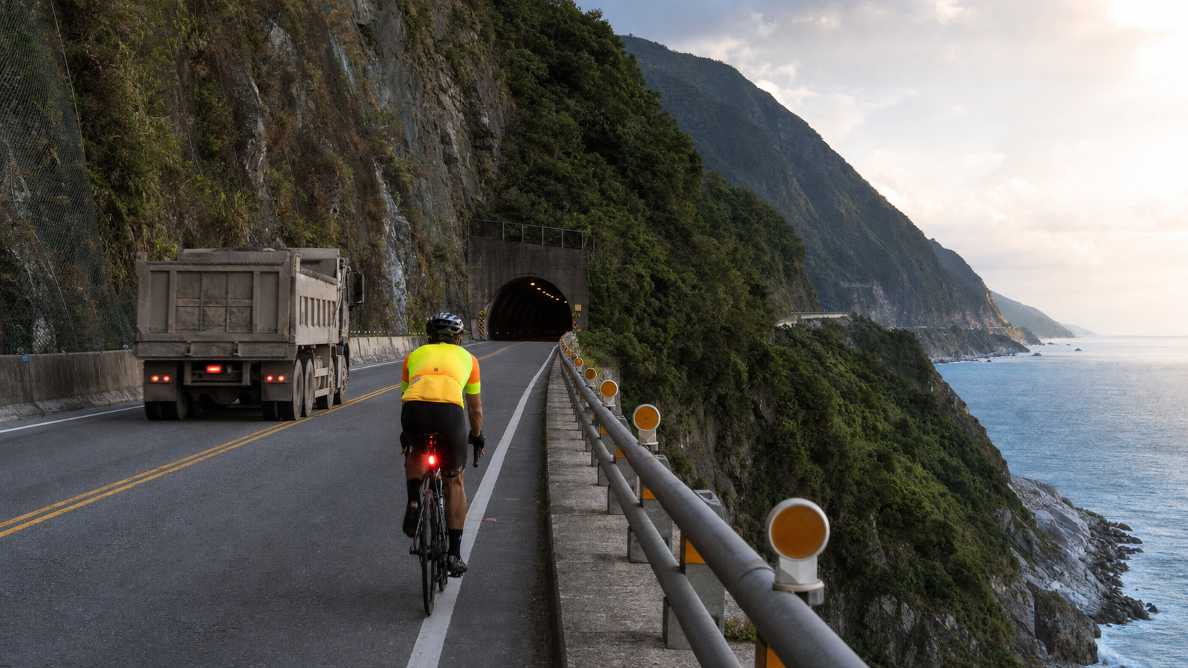
Dangerous sections of the round-island route: Safe riding guidelines for Provincial Highway 9 and the Suhua Highway
Introduction
Taiwan’s round-island route is beautiful, but several sections of highway require extra caution from riders. Every year, round-island cyclists have accidents on the Suhua Highway or Provincial Highway 9, and many of these are avoidable. Understanding where the dangers are, when they are most dangerous, and how to respond is homework that cannot be skipped before a round-island trip.
This article focuses on the two most frequently mentioned dangerous sections: the Suhua Highway (Provincial Highway 9, Hualien to Su’ao section) and other sections of Provincial Highway 9, providing specific and actionable safety guidelines.
Suhua Highway: Taiwan’s most dangerous round-island section
The Suhua Highway (approximately kilometers 118 to 204 of Provincial Highway 9) is about 86 kilometers long and is one of the most spectacular yet most dangerous roads in eastern Taiwan. This stretch includes multiple tunnels, cliffside sections, and frequent gravel trucks.
Main sources of danger
| Danger factor | Description | Area of occurrence |
|---|---|---|
| Heavy gravel truck traffic | Approximately 500 to 800 vehicles pass daily | Entire section |
| Long tunnels (Suhua Improvement Project) | Longest tunnel exceeds 3 kilometers, no natural light | Hanben to Heping section |
| Rockfalls and falling debris | Rocks unstable after rain, debris may be on the road surface | Daqingshui Cliff section |
| Blind curves | Multiple sharp bends prevent gravel truck drivers from seeing riders in advance | Scattered throughout the section |
| Tunnel exhaust fumes | Poor air circulation inside long tunnels | All Suhua Improvement Project tunnels |
Suhua Highway safety guidelines
-
Starting early is the core principle: It is recommended to depart between 5:30 and 6:00 AM, passing the most dangerous sections before 10:00 AM. Gravel truck traffic is heaviest from noon to 2:00 PM.
-
Wear high-visibility gear: Fluorescent yellow or fluorescent orange jerseys, plus front and rear lights (keep flashing lights on even during the day). A powerful front light capable of illuminating the road ahead is mandatory inside tunnels.
-
Tunnel passage techniques:
- Stop before entering a tunnel, and only enter after confirming there is no engine sound from large vehicles ahead
- Ride beside the rightmost lane line (not in the center of the lane)
- Maintain a steady speed, avoid sudden braking
- For longer tunnels, you may hitch a ride (ask waiting trucks on the roadside if the driver is willing to carry you and your bike)
-
Avoid riding after rain or typhoons: Within 24 hours after severe weather, the risk of rockfalls on the Suhua Highway doubles. It is strongly recommended to wait until the weather stabilizes before departing.
-
Inform others of your itinerary: Send a message to family or teammates every day before departing, letting them know your estimated arrival time. Mobile phone signals are unstable in some areas along the Suhua Highway.
Provincial Highway 9 (South Link section): The southern section requiring the most attention
Although the South Link Highway (Fenggang to Taitung section) of Provincial Highway 9 has been improved with tunneling projects, some sections still harbor dangers:
- Fangshan to Fenggang: Many uphill sharp bends, limited visibility for large tour buses
- Around Shouka Bike Station: Highest point climb, fast downhill speeds, noticeably coarse road surface
- Taimali to Zhiben: Occasional gravel on the shoulder, watch for potholes
South Link section recommendations
- Check brake pad wear before the descent from Shouka (elevation 439 meters)
- Avoid riding after dusk; visibility in the mountain area deteriorates rapidly after sunset
- Download offline maps on your phone (Google Maps offline or Komoot); mobile signals are unstable in this area
Provincial Highway 3 mountain sections
Some riders choose Provincial Highway 3 to cross the central mountain area. Although the scenery is beautiful, note the following:
- Narrow road width: Some sections of Provincial Highway 3 are single-lane two-way traffic with almost no shoulder
- Long climbs: Continuous climbing from Dongshi to Zhuolan, high physical exertion
- Tour buses and semi-trailers: Heavy tourist traffic in the mountain area on certain holidays
General safety principles
The following guidelines apply to all dangerous sections of the Taiwan round-island route:
- Always ride on the shoulder or the right side of the slow lane, never occupy the fast lane
- Keep front and rear lights on all day, use flashing mode to increase visibility
- Do not wear earphones, maintain awareness of environmental sounds
- Proactively pull over for gravel trucks: When you sense a large vehicle approaching, pull over to the roadside in advance to let it pass; do not insist on maintaining your speed
- Avoid 7:00–9:00 AM and 4:00–6:00 PM: Large vehicle traffic is dense during commuting hours
Conclusion
The cliffs and the ocean of the Suhua Highway make it one of the most unforgettable sections of the Taiwan round-island route, but it also demands the highest level of attention from riders. Safety is not about being overly cautious; it is about knowing how to ride through the right places, at the right time, in the right way. Be prepared, and you will pass through safely and return home with memories that last a lifetime.
Related reading
- Dangerous sections of the round-island route: Complete safe riding recommendations for the Suhua Highway and South Link Highway
- Eastern coastal section: Challenges and safe riding guide for the Suhua Highway
- Cycling the Suhua Highway: Complete guide to scenery, safety, and itinerary planning
- Suhua Highway riding journal: Cliff scenery and safe riding precautions
單車環島 蘇花公路精彩片段
10 年前
微東進 太魯閣 蘇花 單車兩日遊 ! 颱風過後路況超刺激 行程大亂 | 最狂的鹹酥雞訂單 | CT Yeh | 4K 高畫質空拍絕景!
4 年前
大武山20%魔王陡坡【JJSC南台灣遊騎Day2】!屁股真的要裂開了...凡士林抹滿也沒用?神秘金教堂還有超便宜夜市
3 個月前
高雄綠園道鐵路自行車道 / 外地人能輕鬆駕馭 還是整路崩潰? / 2025 全線開通 春節實地探索一次!(附GPS連結)/ 公路車 / CT Yeh
1 年前
大武山後門26%歡樂陡坡!JJSC南台灣單車行Day2 / 被颱風追著跑 / 公路車 / CT Yeh
2 年前
半日 小台灣 極限單車路線挑戰實錄
7 年前
虎豹潭!日本老師來台一日約騎 台灣車友熱情招待私房路線 / CT Yeh
20 天前
嘉義大埔、阿婆灣挑戰賽,美到以為在日本!ft. 環騎5 Cool 西拉雅188 / 公路車 / CT Yeh
7 個月前