Kujū Nagarenushi Pass → Makinoto Pass Guide: Pacing, Wind Protection, and Summit Tips for a 5.1 km 5.6% Highland Climb
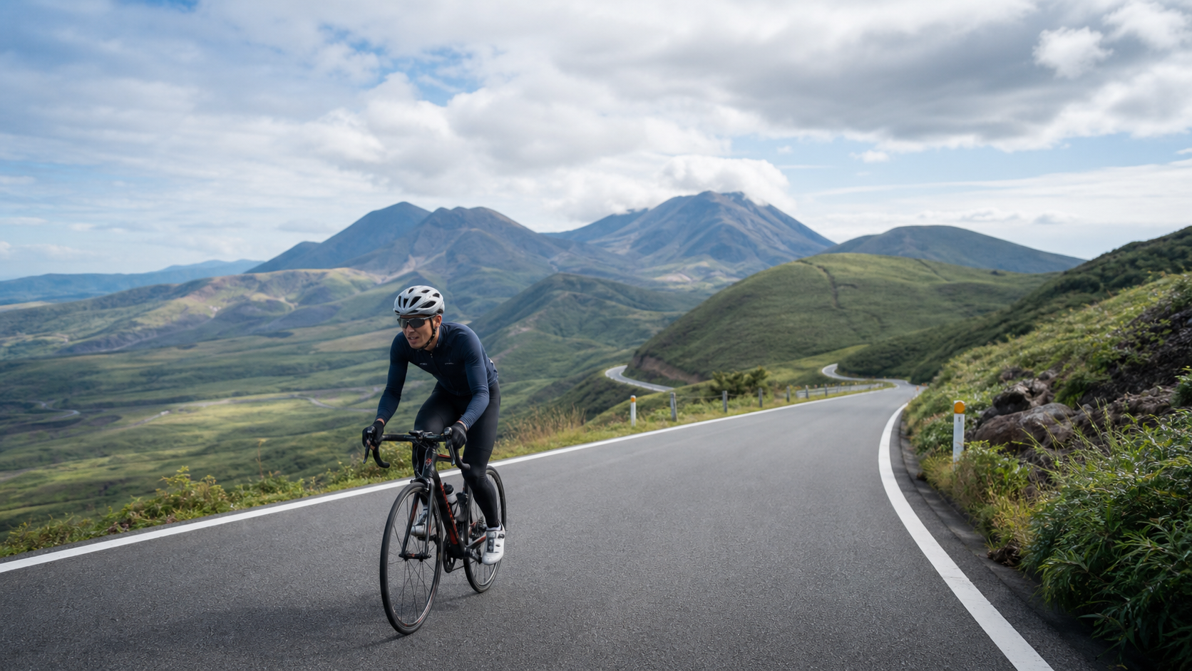
Starting from Chōjūbaru in Ōita Prefecture, Kyushu, and climbing toward Makinoto Pass along the legendary “road you most want to ride in Japan”—the Yamanami Highway—this route perfectly stitches together “stunning views” and “climbing.” The total length is 5.1 km (5,116 meters), with 287 meters of elevation gain and an average gradient of 5.6%, ending at Makinoto Pass at approximately 1,330 meters above sea level, the highest point of the entire Yamanami Highway.
Let’s set the tone with the numbers: 5.6% average gradient, 5.1 km—this is a friendly, short-to-medium distance climb. Using Taiwan routes as an analogy, its scale is roughly equivalent to “a moderate-gradient continuous climb on a section of Hehuan Mountain”—not particularly long, and the gradient isn’t fierce. The real challenge lies in its high-altitude environment (the starting point at Chōjūbaru is already around 1,000 meters) and the Kyushu rooftop scenery that will constantly distract you.
This is a practical guide. We’ll break down the data, segments, gearing, and nutrition clearly so you can save your energy for the views.
1. Reading the Data: A Friendly 5.6% Highland Climb
| Item | Data | Interpretation |
|---|---|---|
| Distance | 5.1 km | Short-to-medium distance |
| Total Elevation Gain | 287 meters | Equivalent to climbing 94 floors continuously |
| Average Gradient | 5.6% | Moderate, approachable |
| Summit Elevation | Approx. 1,330 meters | Highest point of the Yamanami Highway |
| Category | Category 2 | Moderately easy difficulty |
What 5.6% means: This is a gradient that most regular cyclists can grind out while seated, and 5.1 km is within the range most people can complete in one go. The real variables on this road aren’t the gradient—they are:
- High altitude: Both the start and finish are above 1,000 meters, where the air is thinner, temperatures are lower, and weather changes quickly.
- Open, strong winds: The highland terrain offers no shelter, and crosswinds or headwinds can significantly affect how the effort feels.
Key concept: The difficulty of this road is written in its “environment,” not its “gradient.” Get warmth, wind protection, and weather judgment right, and the climb itself becomes the easiest part.
2. Segment Strategy: Breaking 5.1 km into Three Parts
Segment 1 (0–1.5 km): Starting from Chōjūbaru, Gradient 4–6%
Start climbing from the Chōjūbaru area. Chōjūbaru is a famous scenic viewpoint and rest stop on the Yamanami Highway, situated on the highland at the foot of the Kujū mountain range.
- Pacing: Starting at high altitude with thinner air, don’t rush. Begin at a more conservative intensity than you would on flat ground, letting your body adapt to the elevation.
- Cadence: Maintain 80–85 rpm.
- Reminder: The views are already extremely open at the start, with the Tade Plain wetland nearby, but focus first on settling into your rhythm.
Segment 2 (1.5–3.8 km): Core Climbing, Gradient 5–7%
The middle section is the main climbing zone, with a steady gradient of 5–7%.
- Rhythm: This section has an even gradient, ideal for locking in a steady power output and cruising.
- Dealing with wind: The highland offers no shelter. If you hit a headwind, actively shift down to protect your cadence—don’t fight it. If you encounter a crosswind, keep a firm grip on the bars and watch the road surface.
- Nutrition: This section is good for drinking and refueling, because in the later part you’ll be busy looking at the scenery.
Segment 3 (3.8–5.1 km): Summiting Makinoto Pass, Gradient Settles
As you approach Makinoto Pass, the gradient mostly settles, and the sweeping panorama of the Kujū mountain range opens up before you.
- Finishing: If you paced the earlier sections well, you can relax and ride into the highest point here.
- Summit: Makinoto Pass sits at approximately 1,330 meters, with a parking lot, observation deck, and rest facilities—a gathering point for hikers and cyclists. Be sure to watch out for people and vehicles.
3. Gearing and Equipment Recommendations
A 5.6% average gradient doesn’t demand much from your gearing, but the high altitude and potential strong winds suggest leaving some margin.
| Rider Level | Chainring | Cassette | Notes |
|---|---|---|---|
| Advanced / Racing | 50/34 | 11-28 | Easily manageable |
| General Enthusiast | 50/34 | 11-30 | Most recommended; protects cadence in headwinds |
| Beginner / Conservative | 50/34 | 11-32 | For those who want an easy ride |
Equipment essentials:
- Warmth and wind protection (most important): High altitude + open highland = low temperatures and strong winds. Be sure to carry a windbreaker; even in summer, it can get cold on the mountain and on descents.
- Wheels: In strong highland winds, deep-section rims are harder to control in crosswinds; an all-around rim profile is more stable.
- Descent: The Yamanami Highway has long, open descents—make sure your brakes and wind protection are ready.
4. Nutrition and Hydration Strategy
- Water: There are rest facilities around Chōjūbaru for refilling. After you leave, refill points on the highland are limited, so top up before setting off.
- Energy: One serving of carbohydrates before starting is enough; the route isn’t long.
- On the mountain: Both Makinoto Pass and Chōjūbaru have rest stops and food options (seasonal operation), suitable for stopping to refuel and take photos.
5. Weather and Seasonal Considerations
- Spring (April–May): Fresh greenery on the Kujū highland, pleasant climate, but mornings and evenings at high altitude are still cool.
- Summer (June–August): While it’s hot down below, this highland stays cool and comfortable—an excellent summer climbing destination; afternoon fog and thunderstorms are common in the mountains.
- Autumn (October–November): Autumn foliage and silver grass in the Kujū mountain range—one of the most beautiful seasons of the year.
- Winter (December–March): Severe cold at high altitude, with possible snow, ice, and road closures—strongly not recommended for winter attempts.
- General: Highland weather changes extremely quickly; fog, temperature drops, and wind can appear in an instant. Be sure to carry windproof and warm layers, and keep an eye on the conditions at all times.
6. Common Mistakes and DNF Risks
- Underestimating the altitude: Starting at flat-ground intensity, you’ll quickly run out of breath in the thinner air.—Solution: Start conservatively and let your body adapt.
- Insufficient warmth: Judging it as easy based only on the gradient, while ignoring the highland cold and strong winds, leading to hypothermia on the descent.—Solution: Definitely bring windproof and insulating layers.
- Misjudging the weather: Highland weather changes in an instant; fog and temperature drops can catch you off guard.—Solution: Check the forecast before heading out, pack the right gear, and turn back decisively if conditions deteriorate.
- Getting distracted by the scenery: The views are so stunning that you neglect the road and oncoming traffic.—Solution: If you want photos, stop safely first.
7. Target Time References by Rider Level
The following are reference completion times for the approximately 5.1 km, 287-meter climb from Chōjūbaru to Makinoto Pass:
| Rider Level | Reference Time | Average Speed | Intensity Concept |
|---|---|---|---|
| Racing | 15–18 minutes | Approx. 17–20 km/h | Steady rhythm |
| Advanced | 19–23 minutes | Approx. 13–16 km/h | Steady aerobic |
| General Enthusiast | 24–30 minutes | Approx. 10–13 km/h | Easy aerobic |
| Beginner Finish | 31–38 minutes | Approx. 8–10 km/h | Goal is finishing and enjoying the views |
A word to challengers: The gradient of this road gives you “room to enjoy the scenery.” Get your warmth and wind protection right, and put your heart into the sweeping panorama of the Kujū mountain range—when you reach Makinoto Pass, the highest point of the Yamanami Highway, you’ll understand why some say this is “the road you most want to ride in Japan.”
Route data: Distance 5.1 km, total elevation gain 287 meters, average gradient 5.6% (Strava segment), Kujū-machi, Ōita Prefecture, Makinoto Pass at approximately 1,330 meters, the highest point of the Yamanami Highway, a stunning climb on the Kyushu rooftop.
8. The Yamanami Highway in Full: Makanotō Pass Is Only the Cream of the Crop
To truly understand the stretch from Chōjabaru to Makanotō Pass, you first need to see the entire road it belongs to—the Yamanami Highway.
The Yamanami Highway is a scenic road connecting Beppu/Yufuin in Ōita with Aso in Kumamoto, about 50 kilometers long, traversing the heart of the Aso-Kujū National Park. Many Japanese cyclists call it “a road you must ride once in your lifetime,” because it packs nearly everything a cyclist dreams of: vast plateaus, a chain of volcanic peaks, rolling seas of grass, wetlands, lakes, and a road that winds elegantly through the mountains as if it has no end.
And the stretch from Chōjabaru to Makanotō Pass is precisely the climax of the entire Yamanami Highway—because Makanotō Pass sits at about 1,330 meters above sea level, making it the highest point of the entire road. Climb it, and you stand on the rooftop of Kyushu. That is why, even though this stretch is only 5.1 kilometers with 287 meters of climbing, its weight in a cyclist’s heart far exceeds those numbers.
Extended play: Many cyclists don’t ride just these 5.1 kilometers; they embed it into a longer Yamanami Highway epic—starting from Beppu or Yufuin, passing Yufudake, Chōjabaru, and Makanotō Pass, then extending toward Aso, even connecting to Kumamoto’s “Milk Road (Miruku Rōdo).” If you have a few days, this is a dream route that lets you take in the entire rooftop of Kyushu. And the Makanotō Pass section is usually the most spectacular, most unforgettable climax of the whole journey.
9. Real-World Scenario Simulation: A Complete Ascent of Makanotō Pass
Before departure: This is a high-altitude route, so the focus of preparation is “warmth and wind protection.” Top up your water, eat some carbs, confirm your gearing includes a 30–32T, and have your windproof jacket ready at the rest facilities around Chōjabaru (even in summer, it can get cold up top and on the descent). Check the day’s weather—highland weather changes in an instant.
Segment 1 (0–1.5 km): Starting from Chōjabaru, gradient 4–6%. At altitude, the air is thinner, so start more conservatively than you would on flat ground, letting your body adapt to the elevation while maintaining 80–85 rpm. The view is already wide open at the start, but focus on settling into a rhythm first.
Segment 2 (1.5–3.8 km): The core climb, gradient 5–7%. This section is steady, ideal for locking in a stable power output and cruising. If you hit a headwind, proactively shift down and protect your cadence—don’t fight it. If there’s a crosswind, keep the bars steady and watch the road. This section is good for drinking and eating, because you’ll be busy looking at the scenery later.
Segment 3 (3.8–5.1 km): Topping out at Makanotō Pass, the gradient eases, and the sweeping panorama of the Kujū mountain range opens before you. If you paced the earlier sections well, you can relax and ride into the highest point. Arriving at Makanotō Pass, about 1,330 meters above sea level, there’s a parking lot, an observation deck, and rest facilities.
After summiting: Immediately put on your windproof jacket. Makanotō Pass is a gathering point for hikers and cyclists—walk up to the observation deck and take in the vast panorama of Chōjabaru and the Kujū range. Rest, refuel, take photos. When you’re ready to descend, make sure you’re warm enough and your brakes are working—the Yamanami Highway’s descent is long and open, so be sure to control your speed.
10. Tailored Advice for Different Riders
- For first-timers at altitude: The Makanotō Pass section has friendly gradients, but both the start and finish are above 1,000 meters, making it a great choice for experiencing high-altitude riding. Start conservatively, let your body adapt to the elevation, and watch out for strong highland winds and low temperatures. This is an excellent warm-up before tackling higher-altitude challenges (like the Japanese Alps or Taiwan’s Wuling).
- For landscape photography enthusiasts: This is the most spectacular climax of the Yamanami Highway—the Kujū range, seas of grass, the winding road, drifting cloud shadows—everywhere you look is a picture. If photography is your goal, the light is finest at dawn and dusk, but always stop safely before taking shots.
- For long-distance riders: Embed this section into a multi-day Yamanami Highway epic, riding from Beppu/Yufuin all the way toward Aso. Makanotō Pass will be the most unforgettable high point of your entire journey—worth lingering there to truly take it in.
- For group rides: Friendly gradients and stunning scenery make this ideal for group riding. Agree to meet at the Makanotō Pass observation deck, look down over the rooftop of Kyushu together, and take a group photo—it makes for a wonderful memory.
11. High Altitude and Strong Winds: The Real Challenge of This Road
The gradient of the Makanotō Pass section is only 5.6%—it’s not hard. Its real challenge is written in the “environment,” not in the “gradient.”
The effects of high altitude: The start at Chōjabaru is already around 1,000 meters, and the finish at Makanotō Pass is about 1,330 meters. As altitude rises, the oxygen content in the air drops, and the same effort will leave you more breathless than on flat ground. So start conservatively, give your body time to adapt, and don’t charge ahead at your sea-level pace.
Strong winds on the open plateau: With no shelter on the plateau terrain, wind is a regular here. A headwind will noticeably slow you down and increase your perceived effort—when that happens, don’t fight it; proactively shift down and protect your cadence, treating it as an extra climb. Crosswinds demand extra care with handling—keep the bars steady, watch the road, and note that deep-section wheels are especially hard to control in strong crosswinds, so an all-rounder rim is the safer choice.
Rapid weather shifts: Highland weather changes extremely fast—fog, temperature drops, and wind can arrive in an instant. Check the forecast before you leave and keep an eye on the sky at all times. If the weather turns sharply and visibility deteriorates, decisively turn back or shorten your ride—on an open highland plateau, weather is a variable you cannot afford to ignore. Manage these three things—high altitude, strong winds, and weather—and the climb up Makanotō Pass itself will actually be the easiest, most enjoyable part of your day.
12. Deeper Considerations on Gearing and Equipment
The 5.6% average gradient of Makanotō Pass doesn’t demand much from your gearing, but the high altitude and potential strong winds make equipment choices worth a closer look.
Gearing: For most enthusiasts, a 50/34 chainset with an 11-30 cassette is more than enough. In a headwind, that 30T will help you hold your cadence and avoid grinding a big gear and spiking your heart rate—treat the headwind as an extra climb, and having gear range in reserve becomes important. Advanced riders can use 11-28; beginners might bring 11-32 for peace of mind.
Wheels: This is the most important equipment consideration for Makanotō Pass. In strong highland winds, overly deep-section wheels are harder to control in crosswinds—a sudden gust can throw off your balance and make steering difficult. So for this road, an all-rounder rim or shallower wheels are recommended, sacrificing a little aero for stability and safety in the wind. This is the wisdom of “adapting equipment to conditions”—the fastest setup isn’t necessarily the one best suited to the environment at hand.
Warmth and wind protection (most important): High altitude plus open plateau equals low temperatures and strong winds. Be sure to carry a windproof jacket—even in summer, the summit and long descents can leave you shivering. This isn’t a comfort issue; it’s a safety issue—hypothermia can seriously impair your handling and judgment.
Other: The Yamanami Highway’s descent is long and open, so check your brakes beforehand. Cell signal may be unreliable at altitude, so let your riding partners know your route and expected time before you set off. Bring enough water and food—the route isn’t long, but resupply points on the plateau are limited.
13. Nutrition and Hydration Strategy
The Makanotō Pass section isn’t long, but it’s often embedded in a longer Yamanami Highway epic, so your fueling plan should depend on your overall itinerary.
If riding just this section: Top up your water and eat some carbs at the rest facilities in Chōjabaru before starting. Both Makanotō Pass and Chōjabaru have rest stops and food options (seasonal hours), suitable for stopping to refuel and take photos.
If embedded in a longer ride: Plan in units of “hours or even a full day.” Fuel with carbs on a regular schedule—30 to 60 grams per hour—don’t wait until you’re hungry. Drink 500 to 750 milliliters of fluid per hour; between the dry highland air and the exertion, dehydration comes faster than you think. The rest stops and roadside stations (michi no eki) along the Yamanami Highway are key resupply points—make good use of them.
Special note for high altitude: At altitude, your sense of thirst becomes dulled, making it easy to dehydrate without noticing. So at elevation, you must drink on a “schedule,” not “when thirsty.” Treating hydration as a regular task is an important discipline of high-altitude riding.
14. Pre-Ride Preparation and Fitness Planning
Makinoto-toge’s gradient is forgiving, and the pure climbing fitness required isn’t particularly demanding. But if you plan to embed it into a longer Yamanami Highway epic, you’ll need a solid aerobic endurance base. Climbing demands three abilities: aerobic endurance (long hours of Zone 2 base work), threshold power (sweet-spot intervals), and muscular strength with fatigue resistance. For a Yamanami Highway epic, aerobic endurance is the key—you need an engine capable of sustained output for hours.
Additionally, if you’re preparing for a high-altitude route like Makinoto-toge, some “acclimatization” arrangements before the ride are wise: arrive early to give your body time to adjust to the altitude; rest fully and sleep well before departure; avoid sudden high-intensity efforts at altitude. High altitude places extra strain on the body—respect it, adapt to it, and you’ll safely and joyfully enjoy the grandeur of this rooftop of Kyushu. Get your fitness, equipment, supplies, and weather judgment all in order, and Makinoto-toge will reward you with an unforgettable highland ride.
15. Descent Safety: The Long, Open Highland Descent
Reaching the summit of Makinoto-toge is only half the journey. Descending safely from this high-altitude plateau requires equal parts skill and judgment.
Staying warm is the top priority: You’ll be drenched in sweat from the climb, and once you hit the long descent at speed with the wind, combined with the already-low temperatures at altitude, your body heat will drain rapidly. Be sure to put on a windproof, insulated jacket at the summit, after taking photos, before starting down. Hypothermia is a real and dangerous threat on highland descents—it stiffens your fingers and dulls your reactions, directly compromising braking and handling.
Brake management: The Yamanami Highway descents are long. Don’t ride the brakes the whole way down—that will overheat your rims or rotors. Instead, use a “brake before the corner, release through the turn, accelerate out” pulsing technique. On long descents, stop periodically to let the wheels cool down. The majority of braking force comes from the front brake (roughly 70%), applied progressively in coordination with the rear.
Handling in strong winds: The plateau is open and exposed. High speed on the descent combined with strong crosswinds is a major handling challenge. Keep a firm grip, stay relaxed, lower your center of gravity, and don’t panic-correct when hit by sudden gusts. This again reinforces the earlier advice—an all-rounder wheelset is safer on this road than deep-section rims.
Vision and road conditions: Although the highland descent is open with relatively good visibility, still watch for oncoming traffic, gravel on the road surface, and possible wildlife. Always keep a margin of speed. Enjoy the thrill of the descent, but put safety first.
16. Quick FAQ
Q: It’s only 5.1 km—isn’t that too short to make a special trip for? If you only look at the numbers, yes, it’s short. But it’s the highest point of the Yamanami Highway, with scenery so grand it’s a “must-see in a lifetime.” Moreover, most riders embed it into a longer Yamanami Highway epic, and Makinoto-toge is the climax of the whole ride. Whether it’s worth it—you’ll know the moment you stand on the observation deck.
Q: Will the altitude make me breathless? Do I need special acclimatization? At roughly 1,330 meters, most people won’t experience noticeable altitude sickness, but the air is indeed thinner, and you’ll breathe harder than at sea level when you start climbing. Start conservatively and give your body time to adapt.
Q: What’s the best season? Spring’s fresh greenery, summer’s cool escape, and autumn’s crimson leaves and golden grass are all stunning. Winter brings severe cold at altitude and possible snow closures—strongly not recommended. Regardless of when you go, windproof and warm layers are essential.
Q: Do I have to ride up? Can I drive? You can certainly drive. But climbing to the rooftop of Kyushu on your own legs—the sense of achievement and emotion of “arriving under your own power”—is something a car can’t give you. That’s the romance of the cyclist.
17. Conclusion
To sum it all up, Makinoto-toge is this kind of road: 5.1 km, 287 meters of elevation gain, 5.6% average gradient—forgiving in steepness, yet the highest point of the Yamanami Highway, the very top of Kyushu’s rooftop. Its true challenge lies not in the gradient, but in the high altitude, strong winds, and changeable weather; its true value lies in that sweeping panorama of the Kuju mountain range, the surging sea of grass, and the vast landscape of drifting cloud shadows.
Bring ample warm layers and supplies, start conservatively to let your body adapt to the altitude, and save your energy for the spectacular scenery along the way—when you reach Makinoto-toge and stand on the observation deck looking down at that winding road coiling beneath your feet, you’ll understand from the heart why some say this is “the road you most want to ride in Japan,” and you’ll be glad you came. Ride safe, take it all in, and keep the grandeur of this Kyushu rooftop in your memory forever.
Appendix: Makinoto-toge Quick Checklist
| Check Item | Standard | Why It Matters |
|---|---|---|
| Windproof insulated jacket | Mandatory | High altitude + strong winds + long descent = high hypothermia risk |
| Largest rear cassette cog | ≥ 30T | Protects cadence in headwinds |
| Wheelset | All-rounder / shallow rim | More stable handling in strong crosswinds |
| Water and supplies | Top up before starting the climb | Limited resupply points on the plateau; thirst sensation is dulled |
| Weather | Check before departure, monitor constantly | Highland weather changes instantly: fog, wind, temperature drops |
| Brake condition | Inspect beforehand | Long, open descent |
| Itinerary notification | Let companions know your route and timing | Cell signal may be unreliable on the plateau |
Make this checklist your ritual before heading up Makinoto-toge. The more magnificent the high-altitude scenery, the more it demands your caution and respect. Once your preparation is complete, all that’s left is your legs—and that Kyushu rooftop waiting to awe you. Ride safe, and when you stand at the highest point, take a good, deep look, and let that vast highland settle into your heart.
One final detail on high-altitude riding: post-descent cool-down and recovery. Having just completed a highland climb and long descent, your body has simultaneously endured the fatigue of exertion and the stress of altitude and cold. Don’t stop dead once you’re back at lower elevation. Spin gently for ten minutes in your easiest gear at very low intensity, letting your heart rate and blood flow settle down smoothly, and allowing your body to slowly relax from the tension of altitude. Back at your lodging, replenish carbohydrates and protein, do some light stretching, and get plenty of sleep for full recovery. If you’re continuing the Yamanami Highway epic the next day, this recovery work is non-negotiable—it determines whether you can wake up refreshed tomorrow to chase more of the Kyushu rooftop’s magnificent scenery. Take care of your body, and it will carry you further and longer across this highland.
Related Reading
- Standing on the Rooftop of Kyushu: Riding the Yamanami Highway, the Highland Scenery from Chojabaru to Makinoto-toge
- Hakone-toge (Route 1) Practical Guide: Segment Pacing and Gear Ratios for 15.6 km with 846 m of Climbing
- Yabitsu-toge Practical Guide: Segment Pacing and Gear Ratios for 11.5 km with 642 m of Climbing
- The Coming-of-Age Ride for Kanto Cyclists: Yabitsu-toge, a Sacred Ground That Measures Your Fighting Spirit
台北闊瀨陡坡 騎旅 / 日本單車雜誌編輯車友臨時加入!/ 髮香才是最強的 / feat. 北迴歸線小隊 / 公路車 CT Yeh
6 個月前
2025 乘鞍岳登山賽 比賽全紀錄篇 / 完整路線攻略介紹 / 日本版武嶺 公路最高點 / 高山空拍絕景 / 明年會開團! / 公路車 / CT Yeh
10 個月前
新竹羅平 x 天湖部落 大禹嶺級變態陡坡! 4K超高畫質 空拍 | 公路車
5 年前
萬年峽谷! 30% 超激陡坡 里佳部落DAY2 還是很硬! | 公路車 | CT Yeh
3 年前
大禹嶺 到 武嶺牌樓 全程前後實況錄影 | 北進武嶺 | 東進武嶺 | KOM | 訓練台 | 坡度分析 | Taiwan KOM Last 10 km HARD | 公路車
6 年前
2025 乘鞍 KOM 登山賽挑戰實錄 / 日本公路最高 ! 賽前探路篇 / 比富士山厲害,無敵絕景!/ 40週年 / 中文YT首發 / 公路車 / CT Yeh #乘鞍ヒルクライム
10 個月前
大武山後門26%歡樂陡坡!JJSC南台灣單車行Day2 / 被颱風追著跑 / 公路車 / CT Yeh
2 年前
宇老大滿貫 拉拉山 員工旅遊 有如爬了一座東進武嶺 #公路車 4K高畫質
6 年前