The Qingjing-Hehuanshan Loop: An Entry-Level High-Mountain Challenge
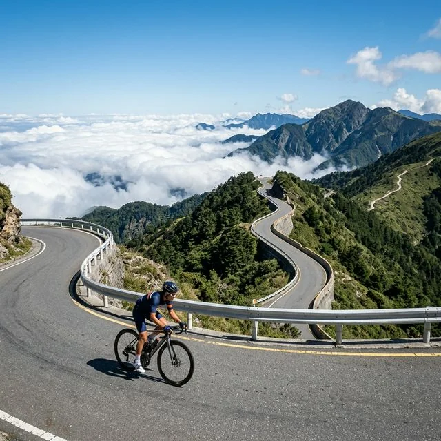
If you want to experience what it's like to ride above 3,000 meters but aren't quite ready to tackle the full Wuling climb from the Hualien side or the complete Central Cross-Island Highway traverse, the Qingjing to Hehuanshan loop is your best choice. This route starts at Qingjing Farm, climbs Hehuanshan along Provincial Highway 14A, and either turns back at Wuling or continues into a full loop. It is Taiwan's most popular high-mountain cycling route, drawing tens of thousands of riders every year on a kind of pilgrimage, and it has become an important symbol of Taiwan's cycling culture.
Route Overview
Start/Finish: Qingjing Farm (Ren'ai Township, Nantou County, elevation approx. 1,750 m)
Highest Point: Wuling (elevation 3,275 m)
Round-Trip Distance: approx. 50 km (Qingjing to Wuling and back)
Full Loop Distance: approx. 75 km (Qingjing–Wuling–Dayuling–Lishan–Qingjing, via Provincial Highway 7A)
Elevation Gain (round trip): approx. 1,600 m
Difficulty: ★★★★☆ (Hard)
Recommended Riding Time: 4-7 hours (round trip)
Climb Analysis: Qingjing to Wuling
Qingjing to Yuanfeng (approx. 11 km, approx. 700 m gain)
Starting from Qingjing Farm, the climb begins along Provincial Highway 14A. The first 5 km sits at roughly 4-5% gradient, steepening slightly after Cuifeng. This stretch runs through dense temperate conifer forest, the air carrying the scent of pine. Cuifeng (elevation approx. 2,300 m) has a weather station, and from here the drop in temperature and thinning air become noticeable. Continuing on to Yuanfeng (elevation 2,756 m), a famous spot for stargazing and viewing seas of clouds, and a good place to rest.
Yuanfeng to Kunyang (approx. 5 km, approx. 300 m gain)
From Yuanfeng to Kunyang, the gradient holds around 5-6%. Here the route enters alpine grassland and the view opens up dramatically. As the tree line recedes, it gives way to low arrow bamboo and alpine rhododendron. On clear days you can see the magnificent ridgelines of Qilai Mountain and Nenggao Mountain in the distance. The Kunyang parking area (elevation approx. 3,070 m) is an important milestone — you’ve broken the 3,000-meter mark.
Kunyang to Wuling (approx. 5 km, approx. 200 m gain)
The final 5 km is the most challenging stretch of the entire ride. The gradient isn’t the steepest (averaging around 4%), but above 3,000 meters elevation, every pedal stroke takes noticeably more effort than at sea level. Breathing becomes labored, heart rate spikes easily, and lactic acid builds up in the thighs at a visibly faster rate. After leaving Kunyang, there’s a short descent to Hehuanshan Lodge before the final climb begins. Hehuanshan Lodge is the last indoor supply stop, offering hot food and drinks.
From Hehuanshan Lodge to Wuling, the final 2.5 km ramps up to 6-8% gradient — the section that tests willpower the most. When you finally see the Wuling stone marker — elevation 3,275 meters, the highest point on any road in Taiwan — you can rightfully say you’ve cycled to the top of a Southeast Asian highway.
Descent Precautions
The descent from Wuling back to Qingjing is a joy to ride, but it’s also where accidents are most likely to happen. Temperatures on the high-mountain descent are extremely low, and wind chill at speeds above 40 km/h can push the perceived temperature close to zero. Be sure to put on a windbreaker, full-finger gloves, and a warm cap or ear cover before descending. There are several sharp bends on the way down, and the road surface may have loose gravel or water — always control your speed and leave plenty of stopping distance. It’s recommended not to exceed 40 km/h.
Full Loop Option
More advanced riders can skip the out-and-back and instead continue east from Wuling to Dayuling, head south on Provincial Highway 7A to Lishan, and finally return to Qingjing via the Lixing Industrial Road, forming a large loop. This full loop is approximately 120 km with an additional 1,500 m of climbing. Note that the Lixing Industrial Road surface is relatively poor — wider tires (at least 28c) are recommended, and it’s best attempted only in good weather.
Training Recommendations
For riders attempting Hehuanshan for the first time, it’s recommended to have at least the following fitness base: a flat-road cruising speed above 25 km/h, the ability to sustain riding on a 5% gradient for over an hour, and single-day riding experience of at least 100 km. Training can simulate long, low-intensity climbs, such as repeated ascents of Yangmingshan in Taipei or Dakeng in Taichung. Cardiovascular fitness is the key to high-altitude riding, so interval training to boost VO2 max is recommended.
Accommodation and Transportation
Most riders choose to stay overnight at a guesthouse in Qingjing the night before, then set out around 5-6 a.m. Qingjing has a wide range of accommodation options, from backpacker hostels to upscale guesthouses. Coming from Taipei, you can take a coach to Puli the day before and ride up to Qingjing as a warm-up (approximately 40 km from Puli to Qingjing, with about 1,400 m of climbing). After completing the challenge and returning to Qingjing, enjoying the local Yunnanese Baiyi cuisine and high-mountain vegetables is the best reward for a day of hard effort.
Photography Tips
Hehuanshan is one of Taiwan’s best spots for cycling photography. It’s recommended to set out at dawn to capture the golden light of sunrise. The Kunyang parking area is an excellent vantage point for shooting Qilai Mountain and seas of clouds. The Wuling stone marker is a must-shoot checkpoint — consider bringing a small flag or team banner. On the descent, the Cuifeng-to-Yuanfeng stretch has several bends that make for great action shots.
Related Reading
- Taiwan’s Classic Mountain Challenge: An In-Depth Guide to Wuling, Hehuanshan, and Qingjing Farm
- Taiwan’s Cycling Hundred Peaks Challenge: A Complete Guide to Conquering Wuling
- Cycling Near Taiwan’s Hundred Peaks: Accessible Routes Around Hehuanshan and Xueshan
- Hehuanshan Cycling Route Guide: Comparing the East and West Approaches
#北橫 + #北進武嶺 最硬的員工旅遊 EP1 | #公路車 #拉拉山 | 明池 | 武嶺 | 武陵農場 | 雲海 | Taiwan Cycling Route Wulin
6 年前
西進武嶺最新路況場勘,台14到清境,還適合騎單車上去嗎?/ 居然有這優勢!?/請開啟字幕/當天現剪/公路車/CT Yeh
2 年前
公路車 北進武嶺 兩日輕鬆遊 空拍 環山部落極致絕景 Taiwan Cycling Wulin
8 年前
台北闊瀨陡坡 騎旅 / 日本單車雜誌編輯車友臨時加入!/ 髮香才是最強的 / feat. 北迴歸線小隊 / 公路車 CT Yeh
6 個月前
太平山單車員工旅遊 | 這樣玩CP值最高!| 公路車
5 年前
大武山後門26%歡樂陡坡!JJSC南台灣單車行Day2 / 被颱風追著跑 / 公路車 / CT Yeh
2 年前
觀霧 變好騎了! | 北高車友爆笑大會師 | 公路車 | 單車旅遊 Taiwan Cycling Route GuanWu
6 年前
大武山20%魔王陡坡【JJSC南台灣遊騎Day2】!屁股真的要裂開了...凡士林抹滿也沒用?神秘金教堂還有超便宜夜市
3 個月前