Suhua Highway Cycling Challenge: The Complete Guide to Riding the Coastal Highway from Su'ao to Hualien
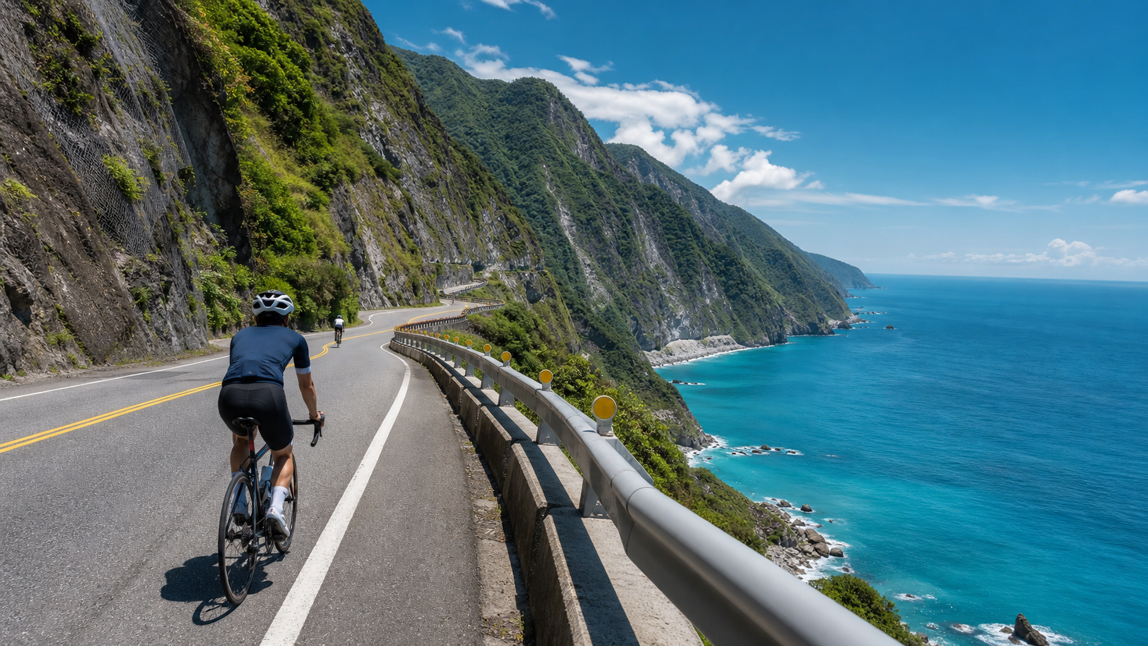
Su Hua Highway Cycling Challenge: The Complete Guide to Riding the Coastal Highway from Su’ao to Hualien
Introduction
The Su Hua Highway (Provincial Highway 9) runs from Su’ao Township in Yilan County in the north to Hualien City in Hualien County in the south, spanning approximately 118 kilometers. Hugging the western shore of the Pacific Ocean along sheer cliffs and azure seas, it is Taiwan’s most iconic and magnificent coastal highway. For cyclists, this route is not just a ride—it is a spiritual journey of encountering nature.
In recent years, following the completion of the Su Hua Improvement Project, some sections have been rerouted through safer tunnel systems, but the traditional Su Hua Highway remains the primary route for cycling. If you want to fully experience that breathtaking Pacific vista, you still need to ride the old Su Hua, while paying attention to passage times on certain controlled sections.
Route Overview
| Section | Distance (approx.) | Main Attractions | Difficulty |
|---|---|---|---|
| Su’ao → Nan’ao | 27 km | Dong’ao Bay, Fenliaolin | Moderate |
| Nan’ao → Heping | 33 km | Heping Bay, Guanyin Great Stone Cliff | High |
| Heping → Chongde | 35 km | Qingshui Cliff | High |
| Chongde → Hualien City | 23 km | Qixingtan, Hualien City | Low |
Main Challenges and Road Conditions
The Su Hua Highway features pronounced undulating terrain, especially on the Heping to Chongde section, where the Qingshui Cliff area rises and falls repeatedly between 50 and 200 meters above sea level—an extreme test of both leg strength and cardiovascular endurance. Here are several key points cyclists must understand:
- Controlled passage times: Some sections of the Su Hua Highway are prone to collapse and have fixed daily traffic control periods. It is recommended to check the latest announcements on the Directorate General of Highways website before departure; controls are generally in effect before 6 a.m. and after dusk.
- Rockfall risk: During the plum rain season and typhoon season (May to October), the risk of rockfall increases significantly. It is recommended to ride during the dry season from October to April of the following year.
- Tunnel sections: Multiple long tunnels are dimly lit. Be sure to have both front and rear lights fully on, and it is recommended to wear fluorescent reflective clothing.
- Scarce supply points: The approximately 35 kilometers between Heping and Chongde have almost no shops. Please stock up on supplies in Heping Township in advance.
Key Supply and Accommodation Points
- Su’ao Township: The last supply point before departure, with convenience stores and bike shops in abundance. You can stock up on energy gels and electrolyte drinks.
- Nan’ao Township: A mid-route supply stop with convenience stores and local eateries, suitable for a short rest or an overnight stay.
- Heping Township: An important relay supply point and the last chance before entering Qingshui Cliff. Be sure to replenish water and food here.
- Chongde: Near Hualien City, with convenient supplies. You can take a brief rest before heading to Qingshui Cliff.
- Hualien City: The finish line, with a wide range of accommodation options, including many bike-friendly guesthouses and hotels.
Practical Advice
Departure Timing
It is recommended to set off between 5:30 and 6:00 a.m., entering during the first wave of controlled passage openings, to avoid the hottest midday hours of unshaded exposure on the cliff sections.
Gear Checklist
- Front and rear lights (essential for tunnels, even during the day)
- Sunscreen (the coastline has intense sunlight)
- Rain gear (mountain weather is changeable)
- At least two spare inner tubes (the road surface has many loose stones)
- Power bank (some sections have no signal)
Mental Preparation
The Su Hua route has no particularly steep climbs overall, but the long, continuously undulating terrain will drain a great deal of energy. First-time challengers are advised to complete the ride over two days, using Nan’ao as the split point, giving yourself ample time to enjoy the scenery along the way.
Emergency Contact
There are multiple police stations along the route where you can seek assistance in case of an emergency. It is also recommended to inform your family of your itinerary before departure and to keep your phone charged.
Conclusion
The Su Hua Highway is more than just a road—it is Taiwan’s most magnificent coastal corridor, a journey where nature and humanity intertwine. The Pacific vista that suddenly unfolds after every turn, and the downhill rush after every hard-fought pedal stroke, all give you a profound understanding of what cycling truly means. After completing this journey, what you take away is not just photographs, but the unforgettable memory of personally experiencing the beauty of the Earth. As long as you prepare thoroughly, respect nature, and ride with caution, the Su Hua Highway will be one of the most treasured chapters in your cycling career.
Related Reading
- Su Hua Highway Cycling Adventure: The Ultimate Riding Experience on the Pacific Cliffs
- Su Hua Highway Riding Full Record: Taiwan’s Most Stunning Coastal Highway Experience
- Yilan Su Hua Highway Cycling Challenge: Coastal Riding Guide from Heping to Su’ao
- The Majestic Ride on Su Hua Highway: Cliffs, Sea Breeze, and the Unbelievable East Coast of Taiwan
半日 小台灣 極限單車路線挑戰實錄
7 年前
單車環島 蘇花公路精彩片段
10 年前
微東進 太魯閣 蘇花 單車兩日遊 ! 颱風過後路況超刺激 行程大亂 | 最狂的鹹酥雞訂單 | CT Yeh | 4K 高畫質空拍絕景!
4 年前
太平山單車員工旅遊 | 這樣玩CP值最高!| 公路車
5 年前
嘉義大埔、阿婆灣挑戰賽,美到以為在日本!ft. 環騎5 Cool 西拉雅188 / 公路車 / CT Yeh
7 個月前
4K單車實境) 嘉義 梅山36灣 訓練台 爬坡 輕鬆騎
6 年前
大武山後門26%歡樂陡坡!JJSC南台灣單車行Day2 / 被颱風追著跑 / 公路車 / CT Yeh
2 年前
爬坡ITT實境)台中 魔王 松鼠坡 首航 6:12 大肚山 大三元 科福路
8 年前