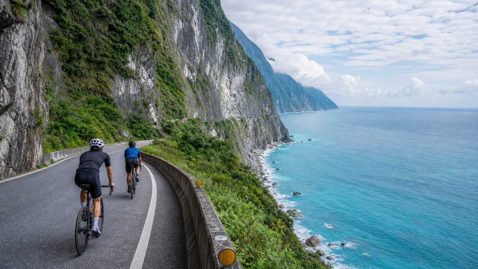
Cycling the Suhua Highway: The Ultimate Riding Experience on the Pacific Cliffs
The Suhua Highway (Section of Provincial Highway 9 from Su’ao to Hualien) stretches approximately 100 kilometers and is the most legendary road in eastern Taiwan. This route runs along the Pacific coast, traversing the cliff terrain on the eastern side of the Central Mountain Range, with the deep blue Pacific Ocean directly below the cliffs—a landscape unrivaled among Taiwan’s highways. However, it is also one of Taiwan’s most dangerous cycling routes, with risks including gravel trucks, falling rocks, narrow road widths, and unpredictable weather.
Route Basic Information
- Starting Point: Su’ao, Yilan (elevation approx. 10 meters)
- Ending Point: Hualien City (elevation approx. 10 meters)
- Total Distance: Approx. 100 km
- Total Elevation Gain: Approx. 1,500 meters
- Difficulty: ★★★★★ (primarily due to risk factors)
- Estimated Time: 6 to 9 hours
Route Options After the Suhua Improvement Project Opened
After the Suhua Improvement Project (Suhua Gai) fully opened in 2020, most vehicles switched to the tunnels, and traffic on certain sections of the old Suhua Highway dropped significantly, making it a more suitable route for cycling. There are currently two main options for riding the Suhua:
Option 1: Full Old Suhua Highway
Ride all the old sections, completely avoiding the Suhua Gai tunnels. The scenery is at its best, but some old sections have poorer road surface quality and require detouring over more mountain roads.
Option 2: Mixed New and Old Route
Use some open sections of the Suhua Gai combined with the highlight sections of the old Suhua. This is currently the most popular choice among riders.
Note: Bicycles are prohibited in the main Suhua Gai tunnels (such as Guanyin Tunnel and Gufeng Tunnel); you must use the old Suhua.
Detailed Section Analysis
Section 1: Su’ao → Nan’ao (approx. 25 km)
This section includes the northernmost climb of the Suhua Highway. Starting from Su’ao New Station, the road begins climbing immediately, crossing the first pass of the Suhua Highway before descending to Dong’ao. Dong’ao Bay is a quiet little fishing village with a beautiful curved beach. From Dong’ao to Nan’ao, you need to cross another small hill.
Supplies: Dong’ao has small shops; Nan’ao’s town center has convenience stores and restaurants. Nan’ao is one of the most complete resupply points on this trip.
Section 2: Nan’ao → Heping (approx. 25 km)
This section is relatively flat, riding along the coastline. You’ll pass the Guanyin Coast Wildlife Refuge and can view the Qingshui Cliffs in the distance. Some parts of the old Suhua Highway in this section have older road surfaces, so watch out for loose gravel.
Supplies: Heping Village has small shops. There are convenience stores near the Heping Industrial Zone.
Section 3: Heping → Chongde (approx. 25 km)—The Highlight Section
This is the most spectacular section of the Suhua Highway and the core area of the Qingshui Cliffs. The road winds along nearly vertical cliffs, with thousand-meter precipices on the left and the deep blue Pacific Ocean on the right. The cliff landscape, with elevation drops exceeding 800 meters, is awe-inspiring.
Climb Information: Starting from Heping, there is a sustained climb of about 8 km, reaching a high point of approximately 450 meters in elevation. After that, it’s a continuous descent to Chongde.
Safety Reminder: This section has the highest risk of falling rocks. Do not stop to take photos in rockfall warning areas. Be sure to turn on your bike lights when passing through tunnels.
Section 4: Chongde → Hualien (approx. 25 km)
After passing Chongde, the terrain levels out. After passing Xincheng (near the Taroko Bridge), you enter the Hualien Plain and finally arrive at Hualien City. This section is the easiest finishing stretch.
Supplies: Chongde has small shops; Xincheng’s town center has convenience stores and restaurants; Hualien City has abundant resupply options.
Safety Precautions
The danger of the Suhua Highway should not be underestimated. The following safety measures must be followed:
Vehicle Threats
- Gravel trucks are the biggest threat—they are massive and have blind spots for drivers
- Try to ride during non-operating hours for gravel trucks (early morning or holidays)
- When you hear a large vehicle approaching from behind, pull over and stop until it passes
- Never compete with gravel trucks for the right of way
Rockfall Risk
- Do not ride the Suhua Highway in the rain or within 24 hours after rain
- Speed up when passing through rockfall warning sections; do not linger
- Watch for loose gravel on the road, which may be a sign of rockfall from above
- Wearing a helmet is a basic requirement
Weather Factors
- Check the weather forecast and avoid riding within one week before or after a typhoon
- During the northeast monsoon season (October–March), winds are strong on this stretch, especially along the Qingshui Cliffs
- Summer afternoon thunderstorms often arrive suddenly; bring a rain jacket
Tunnel Safety
- Make sure your front and rear lights are fully charged and bright enough
- Wear bright-colored cycling jerseys and add reflective strips
- Some old tunnels have slippery road surfaces; slow down when passing through
Best Riding Times
- Best Months: April, May, October, November
- Best Departure Time: 5:00–6:00 AM, aiming to complete most of the route before early afternoon
- Times to Avoid: Consecutive holidays (surge in traffic), typhoon season (July–September, highest risk)
Pre-Trip Preparation
Gear
- High-brightness front light (at least 400 lumens) and rear light (flashing mode)
- Reflective vest or bright-colored cycling jersey
- Windbreaker and lightweight rain jacket
- Plenty of water (recommend carrying 2 liters or more)
- Portable food (energy gels, energy bars, salty snacks)
- Complete repair tools and spare tubes
- Fully charged phone and power bank
Trip Planning
- Inform family and friends of your full route and estimated arrival time
- Note down the phone numbers of police stations along the way
- Confirm your insurance coverage
- Research alternative routes (in case of road closures)
Riding Recommendations
It is recommended to split the ride over two days, staying overnight in Nan’ao or Heping. This not only reduces physical strain but also allows you to enjoy the scenery along the way more leisurely. Completing it in one day is feasible, but riding dangerous sections while fatigued greatly increases the risk.
The Suhua Highway is a route to be respected. Its beauty and danger coexist, requiring thorough preparation and the right mindset. When you safely complete this journey and look back on those moments riding along the cliffs, you’ll understand why it’s called Taiwan’s most magnificent highway.
Related Reading
- Suhua Highway Cycling Challenge: The Complete Guide to Riding the Coastal Highway from Su’ao to Hualien
- Suhua Highway Ride Report: Cliff Scenery and Safety Precautions
- Suhua Highway Ride Full Record: Taiwan’s Most Stunning Coastal Highway Experience
- Suhua Highway Cycling: Complete Guide to Scenery, Safety, and Trip Planning
半日 小台灣 極限單車路線挑戰實錄
7 年前
單車環島 蘇花公路精彩片段
10 年前
微東進 太魯閣 蘇花 單車兩日遊 ! 颱風過後路況超刺激 行程大亂 | 最狂的鹹酥雞訂單 | CT Yeh | 4K 高畫質空拍絕景!
4 年前
台北闊瀨陡坡 騎旅 / 日本單車雜誌編輯車友臨時加入!/ 髮香才是最強的 / feat. 北迴歸線小隊 / 公路車 CT Yeh
6 個月前
大武山20%魔王陡坡【JJSC南台灣遊騎Day2】!屁股真的要裂開了...凡士林抹滿也沒用?神秘金教堂還有超便宜夜市
3 個月前
大武山後門26%歡樂陡坡!JJSC南台灣單車行Day2 / 被颱風追著跑 / 公路車 / CT Yeh
2 年前
太平山單車員工旅遊 | 這樣玩CP值最高!| 公路車
5 年前
阿里山塔塔加 兩倍特濃版!全新隧道開通! 進喔!公路車 | CT Yeh
3 年前