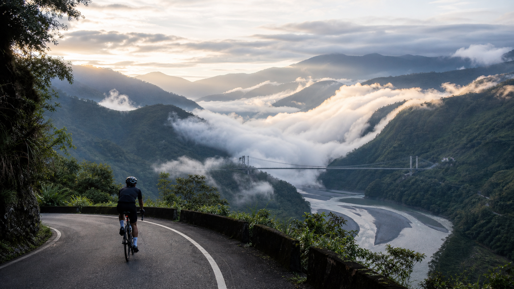
Before your wheels even turn into Wujie, the clouds come to greet you. Setting out from Puli, passing through Zhuoshe Tunnel, the air in the valley suddenly becomes moist and quiet, with the Zhuoshui River carving a crescent-shaped bend below. The Wujie tribe, at an elevation of about 800 meters, is embraced by layers of mountains, with seas of clouds and cloud waterfalls flowing across the mountainsides year-round—locals call it the “Homeland of Clouds,” and some say it is “God’s canvas.”
This industrial road climbing into the tribe from Provincial Highway 71 is about 9.5 kilometers long, with an elevation gain of about 767 meters and an average gradient of 7.8%. The numbers are stark, but this article isn’t about pacing. What I want to introduce you to is this land hidden by mist and clouds—why it’s called Wujie, why the century-old suspension bridge is named “Siyuan,” and how a Bunun tribe quietly guards its own story on the northernmost border.
The Name Wujie: The Boundary of Two Tribes’ Hunting Grounds
The name “Wujie” itself is a memory of geography and ethnicity. It originates from the Bunun word Buqaiz (also written as Vogai or Bogai)—one theory says it means the boundary where two tribes’ hunting grounds met, another suggests it means “to cross over something.” Qing Dynasty documents once transliterated it as “Wugai.” Whichever theory you follow, the character “jie” (boundary) reveals the same thing—this is a border, a place where different peoples and different worlds meet and part ways.
The Wujie tribe belongs to the Bunun’s Zhuoshe group and is the northernmost Bunun settlement. The entire community consists of about a hundred households, with a population of roughly eight hundred to a thousand people. The Zhuoshui River runs through it, dividing the tribe into Jieshan on the west bank and Yuanshan on the east bank. When you ride in, you get the illusion of “entering another time and space”—the outside world moves fast; here, time moves slowly, so slowly that even the clouds are willing to stop and linger on the mountainside for an entire morning.
The phrase “northernmost tribe” carries a completely different weight once you ride in. The Bunun are Taiwan’s quintessential high-mountain people, historically following hunting grounds and settling along the mountain contours. The Zhuoshe group migrated continuously, finally settling in this valley along the Zhuoshui River, becoming the northernmost anchor point of the entire ethnic map. When you realize that the houses before you, the farmland, and this industrial road you’re pedaling up are a boundary that a people defended step by step across many generations—it becomes impossible to treat it as just another “climbing route.” It is someone’s home, and a migration story that is still unfolding.
The Songs of the Bunun: Keeping the Eight-Part Harmony in the Valley
Mentioning the Bunun inevitably brings up the world-renowned “Eight-Part Harmony” (Pasibutbut, the Prayer for Bumper Millet Harvest). It is a polyphonic chorus with no conductor, no sheet music—built entirely on singers listening to one another and layering their voices—regarded as a rare phenomenon of polyphony in human music history. Legend has it that if the singing is harmonious and complete, the millet harvest that year will be bountiful.
I often think that this valley of Wujie itself is like an Eight-Part Harmony being sung—the sound of the Zhuoshui River is the bass foundation, the wind through the forest is the sustained middle voice, and the occasional birdsong and dog barks are the high notes embellishing it. When you ride quietly through it in the early morning, you are, in fact, being “sung to” by the valley in its own way. This is a harmony that the Bunun have tuned through generations of living with this land.
Siyuan Suspension Bridge: A Century of History on One Bridge
Wujie’s most moving landmark is the Siyuan Suspension Bridge spanning the river gorge. It is about 100 meters long, first built in 1919 during the Japanese colonial era—a time when Wujie became an important hub due to hydraulic engineering projects, and this bridge carried the flow of supplies and people. Later, Taiwan Power Company renovated it in 1955 and 2017, keeping it in service to this day.
A bridge standing for over a century is itself a moving story. Think about it—in 1919, an era when even automobiles were rare, what kind of effort did people pour into suspending this bridge over the rushing Zhuoshui River? It has witnessed the busy flow of goods during the Japanese era, the changes of the postwar years, and generation after generation of Wujie people crossing it—children going to school, elders working the fields, wanderers leaving and returning. The bridge you reach so easily on your bicycle today carries the weight of an entire century. When you stand on its deck and feel it sway slightly with your steps, that isn’t just physical motion—it’s more like a century of time gently responding beneath your feet.
The name “Siyuan” is perfectly chosen. It is both a bridge and the gateway to Wujie Dam and Momonaer Waterfall; on a deeper level, it embodies the Bunun people’s sentiment of “remembering the source when drinking water”—never forgetting the source of the water, never forgetting the land’s grace. Standing on the bridge, with the river rushing below and sheer cliffs rising on both banks, you suddenly understand why a bridge could bear this name. It doesn’t just connect two banks; it connects the past and the present.
The Hidden Gems in the Mist
Much of Wujie’s beauty lies in places that require “walking on foot” rather than “riding on wheels”—this is something anyone planning to visit must understand clearly.
Wujie Dam / Wujie Reservoir: Under certain lighting, the lake surface takes on a milky, almost Turkish-blue quality, leading many to list it as one of Taiwan’s hidden-gem reservoirs. It lies quietly among the mountains, like a polished gemstone.
Yixiantian (A Sliver of Sky): A narrow gorge at the confluence of the Lixi Creek, a tributary of the Zhuoshui River, where towering cliffs press in on both sides and sunlight can only filter through the gap—hence the name “A Sliver of Sky.” Reaching it requires walking across riverbeds and through the creek, a hiking route that even involves wading.
Momonaer Waterfall: Meaning “a place with a water source” in the Bunun language, it lies upstream of Wujie Reservoir and likewise requires hiking and wading to approach.
I must be honest: the paths to these hidden gems are meant for feet, not tires. Wujie’s true appeal is “ride to the tribe, then explore the hidden gems on foot”—using the bicycle as the means of arrival and your feet as the key to going deeper.
I especially want to talk about that “Milk Lake.” The water held back by Wujie Dam, under specific light and sediment conditions, takes on a strange color that is almost Turkish-blue yet carries a milky texture. It isn’t always this beautiful—it depends on the season, the water level, and the angle of the sun that day, like a shy child who only shows its best side when the mood is right. Precisely because of this, those who have seen the Milk Lake at its finest never stop thinking about it. That sense of “not something you can count on” is exactly why a hidden gem is a hidden gem: it doesn’t beautify itself for anyone, and whether you encounter it is entirely a matter of fate.
This also brings up a very important reminder that is often overlooked: all this beauty hidden in the mist requires getting off the saddle and using your feet, even wading through water, to reach it. Too many people are drawn here by photos of Yixiantian and Momonaer Waterfall online without realizing those are hiking routes that require crossing riverbeds and stepping through streams—and they end up riding their road bikes into the river valley, stuck between a rock and a hard place. Before coming to Wujie, please be absolutely clear about “which roads are ridable and which are walkable”—this is both for your safety and the most basic respect for this land.
The Homeland of Clouds: Why You Should Rise Early
Wujie being called the “Homeland of Clouds” is not a romantic metaphor but a real geographical phenomenon. The area is rich in moisture, and in the early morning the valley is often blanketed in a sea of clouds. As the sun rises, cloud waterfalls slowly spill over the ridgelines, like white rivers surging through the mountains.
For this reason, Wujie’s most rewarding moment is always the early morning. Set out before dawn, reach the high points before the sun burns the clouds away—in that moment, an entire sea of clouds churns beneath your feet, and distant peaks emerge like islands floating on the sea. This is an awe no photograph can fully convey, and it’s why so many photographers and riders are willing to climb in the dark, just for a few dozen minutes of this canvas.
The first time I saw a cloud waterfall in Wujie was on a slightly cool morning. It had rained the night before, and the valley was saturated with moisture. As dawn broke, I gasped my way up the final steep stretch, and the moment I looked up, I froze—the clouds weren’t lying still; they were “flowing.” They slowly spilled over the distant ridgeline, like a white river, silently pouring into the valley. In that moment, I forgot the ache in my legs and the pounding of my heart, feeling only how fortunate I was to have earned this height through such effort, to witness a mountain “breathe” with my own eyes. I finally understood the name “God’s canvas”—because that scene truly didn’t seem like something that belonged to this world.
And because the sea of clouds belongs only to the early morning, only to those days when the previous night carried enough moisture, it forces you to rise early and to tackle the hardest climb in your most tired hours of the day. This is the deal Wujie makes with you: you must first pay the price of climbing in the dark, and only then will it hand you those few dozen minutes of canvas. And everyone who has truly seen it will tell you—worth it, absolutely worth it.
The Warmth of a Road: Riders and the Tribe
Wujie is not a place born for tourism. It is a real tribe where people live, farm, and children go to school. When you ride in, you are, in fact, walking into someone’s home.
This gives the road to Wujie a weight that other routes don’t have. It reminds every rider: speed is not the only value—respect is. Slow your wheels, nod to the residents you pass, slow down and yield to children playing by the roadside, and remain humble toward the rhythms and culture of this land—these matter more than any climbing record.
The Wujie tribe also offers local cuisine and agricultural specialties for riders who have come from afar to rest their legs and warm their stomachs. As for what to eat and where to go, I suggest asking and choosing on-site, because the tribe’s best qualities are often found in encounters that “aren’t in the guidebooks.”
I still remember a scene. Once, while repairing a flat tire in the shade at the edge of the tribe, an elderly woman working in the fields walked over. She said little, simply handed me a freshly picked fruit and said with a smile, in slightly halting Mandarin, “Riding in the mountains—be careful.” I still remember the sweetness of that fruit to this day. It wasn’t a supply stop found in any guidebook, nor a sight written about in any travelogue—it was simply the most natural kindness a tribal resident offered to a breathless outsider on a bike. Wujie’s warmth is hidden in such unguarded encounters.
This is also why I keep emphasizing “slow down.” When you slow your pace, you have the chance to catch these subtle moments of warmth; when you race through the tribe, you miss not just the scenery but also the softest side of this land. Wujie is not an arena for “setting records”—it is a home where people live quietly. The more you respect it and the more willing you are to slow down, the more it gives back to you in things no photograph can capture and no cycling computer can record.
What This Road Means to Riders
If Sun Moon Lake teaches riders to “converse with the lake,” then Wujie teaches “humility before the mountain.” A continuous 7.8% climb will grind away your restlessness inch by inch, forcing you, in the breathless gasps, to relearn how to slow down and see clearly what is before you.
When you finally ride into the tribe, lean your bike against the Siyuan Suspension Bridge, watch the Zhuoshui River rush by and the clouds surge over the mountain—you will understand that what you climbed was never just 767 meters of elevation, but a span of a century of time, a people guarding the northernmost border, and a sea of clouds willing to linger for those who rise early.
One Climb, One Lesson in Humility
If Sun Moon Lake’s 2.9% average gradient is a metaphor about “don’t be fooled by appearances,” then Wujie’s continuous 7.8% climb is a long lesson in “humility.” This road gives you no room for shortcuts—no flats to recover your strength, no descents to sneak a rest. You can only trade every meter of elevation honestly, inch by inch, with your legs.
I’ve found that when people are oxygen-deprived, gasping for breath, and their cadence has dropped as low as it can go, they become unexpectedly honest. The restlessness, the stubborn pride, the urge to compete with others—all of it gets worn away by the relentless climb, until only the simplest thing remains: pushing down on the next pedal stroke. What Wujie taught me isn’t how to ride faster, but how to make myself as small as possible, keep my rhythm as steady as possible, and hold the greatest respect for the mountain when things are hardest. It made me understand that some heights were never meant to be reached by “conquering,” but by “drawing near.”
The Zhuoshui River: A River’s Nourishment and Temperament
Much of what makes Wujie what it is can be credited to the Zhuoshui River below. It is Taiwan’s longest river, rushing down from the Central Mountain Range, carving a graceful crescent bend at Wujie, splitting the tribe in two, and nourishing the farmland and lives on both banks all the way along. During the Japanese colonial era, people recognized the power of its current and built hydraulic works here—Wujie Dam and the diversion tunnel came into being, and the river’s fate has been tightly bound to this land ever since.
Riding up the industrial road that winds along the river, you can hear the sound of the water the entire way—sometimes low and sustained, sometimes suddenly roaring around a bend. It’s like an old friend who doesn’t say much but is always by your side, accompanying you through every steep stretch. When you stop at a curve and look down at it rushing through the valley floor, you gain a concrete and profound appreciation for the phrase “water is the source of life.” This river has nourished tea, nourished fields, nourished a people, and today it nourishes the breathtaking valley scenery before your eyes.
Wujie Through the Seasons: The Cloud Is the Only Constant Protagonist
Each season in Wujie has its own character, but the cloud is always the unchanging protagonist of this valley. In spring, the mountains are at their most verdant, and after rain the mist rolls in fast and thick, with the hidden gems’ streams at their fullest; in summer, the morning sea of clouds is at its most magnificent, but afternoon thunderstorms and rockfalls remind you that the mountain has a temperament not to be underestimated; in autumn, the sky is high and clear with the best visibility, and the layers of distant mountains stretch all the way to the horizon; in winter, it is cool, quiet, and sparsely visited—the best season to have this peace all to yourself.
No matter which season you come, Wujie will remind you through its clouds: its beauty requires you to match its rhythm—rise early, be patient, and wait humbly. It is not a sightseeing spot you can see on demand, but a landscape you must “earn” with sincerity. And precisely because of this, every encounter that comes as hoped is all the more precious.
The Gateway to the Mountains: Wujie and Its Neighboring Tribes
Spreading out a map of Ren’ai Township, Wujie is not an isolated outpost but a gateway into the mountains. Heading inward from Puli, besides the road to Wujie via Provincial Highway 71, there are several other mountain paths leading to Bunun and Seediq settlements nearby, loosely connected by the Zhuoshui River watershed. For example, other settlements in Fazhi Village, also part of Ren’ai Township and deeper into the mountains, as well as the Wanfeng (Qubing) area extending further up the Zhuoshui River, share a similar geographical character with Wujie—embraced by high mountains, connected to the outside by a winding mountain road, and living at their own tribal pace.
If you’re familiar with the road network of Nantou’s mountain region, you’ll also know that in the direction of Lixing, another famous industrial road crosses the mountain range into Heping District, Taichung—a route legendary among Taiwan road enthusiasts, with gradients and difficulty far exceeding Wujie’s. What I want to emphasize here is a resonance of mindset, not a connection of itineraries: these roads leading to tribes in Nantou’s mountains each have their own gradients, risks, and physical requirements. Casually applying the Wujie experience to other deeper, longer mountain paths is the recklessness riders should most avoid when planning. Riders who truly want to explore this mountain region should do separate research and separately assess their fitness and equipment, rather than treating one successful experience as a pass.
One of the things Wujie taught me is this sense of “knowing your limits.” There are still too many stories waiting further up the Zhuoshui River in this mountain region, but every stretch of road deserves to be approached with the preparation and respect it warrants, rather than being hastily crammed into a single itinerary.
The Tribe’s Daily Life: Not Existing to Be Seen
Riding into Wujie, it’s easy to be drawn to the sea of clouds and the suspension bridge, while overlooking that this is first and foremost a place where “daily life” operates. People bend over their work in the fields, freshly harvested crops dry under the eaves, children chase each other through the alleys after school—these scenes are not backdrops staged for tourists, but the real lives this tribe has stacked up day by day over decades.
I’ve come to understand that a good visitor should learn to make themselves smaller. Not holding a camera up to chase every “picturesque” moment, but first slowing down and letting your presence disturb the land’s original rhythm as little as possible. Much of Wujie’s beauty comes precisely from the fact that it hasn’t been over-designed into a tourist theater—it has kept its own breathing, and what riders need to do is learn to match that breathing, rather than demanding it conform to your itinerary. This unpolished authenticity is its most precious quality.
And because of this, every time a tribal resident naturally nods to me, or a child glances at me with curiosity, it makes me feel I have truly “been to” Wujie, not just “passed through” it, far more than capturing a perfect sea-of-clouds photo ever could.
A fellow rider once described Wujie to me this way: “Other routes, you conquer them. Wujie decides whether it will let you near.” I love that phrase. Because Wujie has never attracted people with grand landmarks or bustling commercial streets—it relies on a quiet yet solid presence: the mountain is still that mountain, the river is still that river, and the tribe still lives at its own pace. Whether you come or not, it is there, neither more nor less. And it is precisely this posture of not pandering that sends every rider willing to slow down and approach with humility down the mountain with more than they expected.
Side Trips and Reminders
- Siyuan Suspension Bridge: Wujie’s signature landmark and the gateway to the reservoir and waterfalls—worth stopping for.
- Wujie Dam’s “Milk Lake”: The lake’s color under good light is the visual centerpiece here.
- Yixiantian and Momonaer Waterfall: These are hiking/wading hidden gems that require walking—know your limits and prioritize safety.
- Sea of Clouds at Sunrise: You must rise early to see it, and be mindful of slippery conditions and fog in the mountains at dawn.
- Tribe Etiquette: Slowing down, yielding, and showing respect is the most important piece of equipment for entering Wujie—more precious than any expensive frame.
Conclusion
On the day I descended, I sat by the Siyuan Suspension Bridge for a long time. The clouds had mostly been burned off by the sun, and the valley had returned to a clear, verdant green, with the Zhuoshui River still flowing at its unhurried pace. Looking at my bicycle beside me, dusted with mountain road grime, I suddenly felt it wasn’t just a tool that carried me up the mountain—it was my way of “visiting” this land. I came, I gasped, I was awed by the clouds, I was warmed by the sweetness of a fruit, and then I left quietly, carrying a full measure of respect. A ride like that is worth more than any timed record.
At the end of Wujie’s industrial road, there is no grand finish arch—only a Bunun tribe embraced by clouds and a century-old suspension bridge named “Siyuan.” It trades its hardest gradients for the softest clouds; it hides its deepest stories behind the farthest distance. For riders who know how to slow down and stay humble, Wujie is not a road to be “conquered,” but a land willing to let you “draw near.” When you one day roll your wheels onto this road, remember to take a good look, for me, at that sea of clouds that lingers for those who rise early. This is the homeland of clouds.
Related Reading
- Wujie Industrial Road Climbing Guide: Gear Ratios and Pacing for the 7.8% Continuous Climb
- On Xuewunao’s 10.2% Gradient, I Learned to Talk with My Limits
- Riding to the Foot of North Dawu Mountain: A Cycling Dialogue with Jiaping Tribe and the Holy Mountain in Taiwu Township
- Deep in the Clouds: Riding into Mingchi on the Northern Cross-Island Highway, a Century-Spanning Journey
台北闊瀨陡坡 騎旅 / 日本單車雜誌編輯車友臨時加入!/ 髮香才是最強的 / feat. 北迴歸線小隊 / 公路車 CT Yeh
6 個月前
大禹嶺 到 武嶺牌樓 全程前後實況錄影 | 北進武嶺 | 東進武嶺 | KOM | 訓練台 | 坡度分析 | Taiwan KOM Last 10 km HARD | 公路車
6 年前
觀霧 變好騎了! | 北高車友爆笑大會師 | 公路車 | 單車旅遊 Taiwan Cycling Route GuanWu
6 年前
【武嶺全紀錄】均推4.x太瘋狂!JJSC破三圓夢直播,直擊2h38m
3 個月前
#北橫 + #北進武嶺 最硬的員工旅遊 EP1 | #公路車 #拉拉山 | 明池 | 武嶺 | 武陵農場 | 雲海 | Taiwan Cycling Route Wulin
6 年前
新竹白蘭部落! 爬陡坡還能講笑話...? 廢物伙伴の約騎 | 公路車 | CT Yeh
4 年前
大武山後門26%歡樂陡坡!JJSC南台灣單車行Day2 / 被颱風追著跑 / 公路車 / CT Yeh
2 年前
司馬庫斯 | 單車員工旅遊 | 比武嶺還接近上帝的路 | 2021 全面實況 路況解析 | 空拍 櫻花炸開超濃密 | 財伯觀光果園 | CT Yeh
5 年前