Summiting Between Clouds and Silvergrass: Datun Mountain Navigation Station, a Pilgrimage Route for Northern Taiwan Cyclists
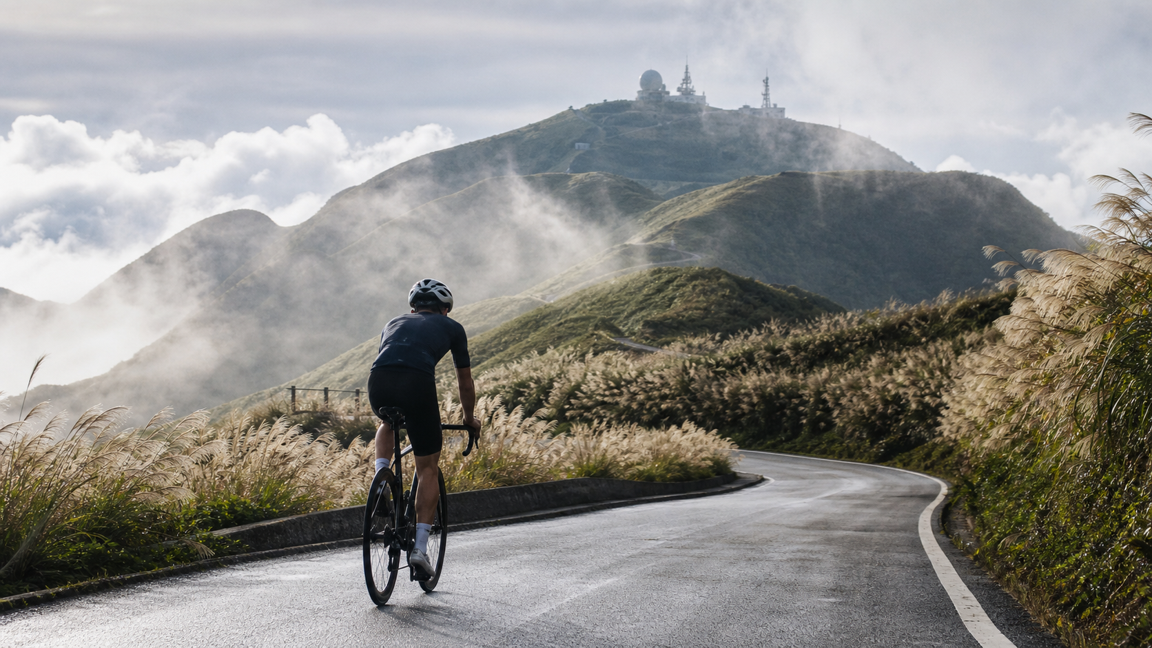
Some routes, you ride for the mileage and the gradient; others, you ride as a process of dialogue with the mountain. The Datun Mountain Navigation Station belongs to the latter.
A Legend Among the Volcanic Group: The Geography and History of Datun Mountain
To understand the weight of the Datun Mountain Navigation Station route, you must first get to know the mountain beneath your wheels. Datun Mountain, with its main peak at 1,092 meters, is a conical active volcano situated within Yangmingshan National Park, spanning the administrative districts of Beitou and Shilin in Taipei City. It is not just an ordinary suburban mountain—it is Taiwan’s only active volcano. That statement may sound simple, but behind it lies a geological evolutionary history spanning over 2.5 million years. According to geological research data, the most recent eruption activity of the Datun Volcano Group occurred approximately 6,000 to 5,000 years ago, and in 2017, a research team from Academia Sinica confirmed for the first time with scientific evidence that a magma chamber indeed exists beneath the Datun Volcano.
In other words, when you ride on this road climbing toward the Navigation Station, every pedal stroke your legs turn is turning atop the very fabric of a dormant active volcano. This awareness subtly transforms how you perceive this road—it is no longer merely “a very steep mountain road,” but a journey in dialogue with geological timescales.
The geological structure of Datun Mountain belongs to the Datun Mountain subgroup within the Datun Volcano Group, sharing this volcanic family with the neighboring Mt. Miantian (elevation 977 meters). Mt. Miantian is a parasitic volcano of Datun Mountain, with rock layers composed primarily of hornblende-two-pyroxene andesite, estimated to have formed around 400,000 years ago, and is a typical bell-shaped volcanic landform. These mountains are interconnected, sharing the same geological lineage, which gives the entire Yangmingshan National Park its distinctive volcanic geomorphology—this is also why, during your ride, you will continually see mountain silhouettes and surface textures completely different from any other road in Taiwan.
The destination itself—the “Navigation Station”—also carries its own unique modern significance. It is an aviation navigation facility established by the Civil Aeronautics Administration of the Ministry of Transportation and Communications, tasked with the critical mission of assisting aircraft navigation, situated at a commanding high point near the main peak of Datun Mountain. The site selection logic is straightforward: the summit offers an open view and prominent terrain, making it an ideal location for transmitting navigation signals. Precisely because it is a functioning aviation infrastructure rather than a tourist attraction, general visitors and vehicles cannot enter the core facility area—but this does not hinder it from becoming a spiritual landmark for road cyclists in northern Taiwan. Over the years, “riding to the Navigation Station” has gradually evolved into an informal challenge ritual among the cycling community—not to enter the facility itself, but to reach this symbolic high point, proving one has conquered this legendary monster climb.
Scenery Along the Way: From the Serenity of Erziping to the Mist-Shrouded Balaka Road
The most captivating aspect of this route lies in how it condenses the vastly different landscape characters of Yangmingshan National Park into a mere seventeen kilometers.
The Erziping area you pass through en route, at an elevation of approximately 815 meters, sits on the leeward side of the western flank of Datun Mountain and is frequently shrouded in clouds and fog. The trail system here is quite distinctive—the Erziping Trail, stretching about 1.8 kilometers, is Taiwan’s first fully barrier-free trail designed with no steps whatsoever, and nature travel writer Liu Ke-xiang once described it as a “five-star trail.” However, it should be noted that bicycles are prohibited on this trail itself; cyclists actually ride the adjacent Balaka Road (County Highway 101A) rather than the trail proper. If you wish to savor the serene ecology of Erziping in detail, it is advisable to plan a separate hiking trip, experiencing cycling and hiking as two distinct outings.
Balaka Road itself is a road worth discussing in detail. This road, spanning approximately 11.03 kilometers in total, was originally constructed in 1952 by military engineering units as a wartime defense road, connecting Beixinzhuang in Sanzhi District, New Taipei City, to the Taipei city boundary, ultimately linking to Yangjin Highway toward the Xiaoyoukeng area. It is precisely because its lineage stems from a wartime defense road rather than a tourism-oriented planned road that Balaka Road’s surface characteristics are “narrow with sharp curves and steep gradients”—which also explains why the gradient sensation on this route feels so violently undulating and full of tension. Riding on a road with nearly seventy years of history, you can almost sense the traces of those military engineering units cutting through the wilderness among the forests, which today has become a training ground for road cyclists challenging themselves.
As the elevation continues to climb, the vegetation on both sides of the road quietly transforms. Low-elevation broadleaf forests gradually give way to silvergrass landscapes and dwarf shrubs, and the views open up accordingly. On clear days, looking back, you can overlook the building clusters and river patterns of the entire Taipei Basin; in the distance, the graceful ridgeline of Guanyin Mountain and the glimmering waters at the mouth of the Tamsui River will quietly slip into the corner of your vision during your gasping moments. When weather conditions are exceptional, there is even a chance to glimpse the color of the Taiwan Strait and the faint silhouette of Guishan Island to the northeast—that moment of glimpsing a vast seascape from on high, amid heavy breathing, is the most luxurious reward this route bestows upon its riders.
Silvergrass, Seas of Clouds, and Sunsets: A Seasonal Visual Feast
The most celebrated natural spectacle of the Datun Mountain range is undoubtedly the autumn silvergrass and seas of clouds. Every autumn, the observation deck areas near the main peak of Datun Mountain are covered in vast expanses of silvergrass, with golden plumes swaying in the wind, set against the glow of the setting sun, creating one of the most iconic seasonal scenes in Yangmingshan National Park, attracting large numbers of visitors who come specifically to admire it. For cyclists who choose to challenge this route in autumn, this means you are not merely completing a physical trial—you are, with your own legs (or rather, two wheels), personally riding into a golden tableau swaying in the wind.
Seas of clouds are another sight that can only be encountered by chance. Due to the significant orographic uplift effect of the Datun Mountain area, combined with the interaction of moisture from the nearby ocean, this region is frequently enveloped in clouds and fog. Under specific meteorological conditions—typically in the early morning or during the development of afternoon convective cloud systems in the mountains—the area below the mid-mountain will be covered by vast cloud layers, leaving only the peaks floating like islands above a sea of clouds. If you arrive at the high point near the Navigation Station at the right time, within the right weather window, what unfolds before your eyes may well be a spectacular vision of rolling, surging clouds—that surreal sensation of being suspended above the clouds is an experience that flatland riding can never provide.
Of course, the clouds and fog also have their more serious side. The Datun Mountain area has occasional snowfall records in winter, and with the direct buffeting of the northeast monsoon, the perceived temperature during cold snaps can be quite low. This is also why this route almost changes its character with each season: fresh greenery in spring, sultry heat with frequent thunderstorms in summer, swaying silvergrass in autumn, and bone-chilling winds or even snowfall in winter—the same route, four entirely different riding memories.
First-Person Narrative: The Inner Dialogue Between the Pedals
Riding up Datun Mountain Navigation Station is, to a certain extent, a practice of dialogue with oneself.
In the first few kilometers of the climb, the body still carries the inertia of flatland riding; the breathing rhythm has not yet fully transitioned, and the mind is still calculating pace and heart rate numbers. But as the gradient begins to undulate and consecutive corners appear, rational calculation gradually gives way to more primal sensory experience—you begin to feel the soreness and swelling in your thigh muscles, the frequency of sweat dripping down your chin, the temperature changes brought by the wind brushing against your cheeks.
The steep sections in the middle that catch you off guard always appear just when you think you have figured out this road’s temperament. One moment you might be enjoying a brief respite on a gentler grade, and the next, a nearly vertical visual illusion suddenly unfolds before your eyes—that is the true sensation brought by a route whose total elevation gain far exceeds what the average gradient estimate suggests: violently undulating, utterly unpredictable, forcing you to remain vigilant at all times without the slightest slackening. This process of “outsmarting” the terrain is, in some ways, more captivating than sheer physical exertion—it demands not only that you be strong, but that you know how to read the road surface, anticipate gradients, and manage your own psychological rhythm.
As the clouds and fog gradually roll in and visibility begins to drop, the sounds around you seem to be absorbed by the moisture, leaving only your own heavy breathing and the faint whirring of the chain. At this point, riding almost enters a state akin to meditation—all the clamor of the outside world is sealed off down the mountain, leaving only the stretch of road before you, this one pedal stroke, this one breath. Many riders who have tackled this route mention a similar psychological turning point: once the pain reaches a certain threshold, a strange calm sets in instead; the body automatically finds the most efficient pedaling cadence, and thoughts settle along with it.
And when the silhouette of the Navigation Station finally appears in your field of vision, that complex emotion of relief mixed with accomplishment is often the most profound reward this route gives its riders. You cannot help but recall the version of yourself a dozen-plus kilometers ago who hesitated about whether to set out, and you also realize that it is precisely the repeated tug-of-war along the way—with the gradients, with the clouds and fog, with self-doubt—that makes this moment of arrival so precious.
What This Road Means to Cyclists: A Ritual of Identity
In the road cycling community of northern Taiwan, “have you ridden up to the Datun Mountain Navigation Station” has, to a certain extent, evolved into an unspoken marker of identity—not that those who haven’t ridden it are any less qualified, but rather that those who have share a silent understanding between them. Like Yangjin Highway and Fengguizui, the Navigation Station is not just a geographical coordinate but a vessel of collective memory, carrying the shared experiences of countless riders gritting their teeth through clouds and fog, nearly giving up on steep slopes yet pushing through anyway.
The appeal of this type of challenge route transcends, in some ways, pure exercise physiology. It offers an experience that modern people find increasingly rare: within a process that has a clear starting point and endpoint, with objectively measurable difficulty, you personally verify just how far your willpower and physical capacity can take you. Unlike the many vague, hard-to-quantify challenges in daily life, climbing is cruel and honest—the gradient doesn’t change based on your mood, and the mileage doesn’t shorten because of your excuses. Whether you can reach the Navigation Station depends solely on your preparation and perseverance.
Suggested Add-ons: Extending the Challenge into a Full Mountain Journey
If your schedule allows for more flexibility, consider extending the Datun Mountain Navigation Station challenge into a more complete Yangmingshan National Park excursion.
Erziping Ecological Stroll: After reaching the summit, if your energy and time permit, consider changing into casual shoes and strolling along the nation’s first barrier-free trail around Erziping, savoring the tranquil forest scenery and pond ecology of what Liu Kexiang described as a “five-star trail”—a moment of relaxation in stark contrast to the gasping for breath you experienced on the slopes just moments before.
Miantian Mountain and Xiangtian Mountain Trail System: For riders who love being close to nature and still have energy to spare, the nearby Miantian Mountain, Xiangtian Mountain, and Caigongkeng Mountain areas all have complete hiking trail systems to explore—an excellent extension option that combines cycling with mountain hiking.
Hot Spring Relaxation: Yangmingshan National Park has multiple hot spring bath facilities. After a full day of climbing challenges, soaking in a hot spring to soothe tense muscles is a quintessentially authentic way to wrap things up.
Photography Timing Planning: If your goal is to capture sea of clouds or sunset views, it’s recommended to check weather data in advance, choose a departure time during a stable early morning or afternoon convective window, and allow ample time to wait near the summit for the moment when light and cloud conditions align.
Transportation Backup: If you’re not planning a round-trip ride with your bike, but instead a one-way challenge with a separate shuttle descent, pay attention to the bus system schedules within the park as a backup plan in case of fatigue or sudden weather changes.
What the Datun Mountain Navigation Station teaches riders is perhaps not just how to conquer a steep mountain road, but how to keep choosing to pedal forward at moments when the clouds refuse to clear and the gradient refuses to ease. This is the most precious souvenir this legendary demon climb of northern Taiwan leaves for every challenger.
A Triangular Dialogue with Yangjin Highway and Fengguizui: The Demon Climbs of Northern Taiwan
If you place the Datun Mountain Navigation Station within the family tree of northern Taiwan’s demon climbs, you’ll discover something interesting: Yangjin Highway, Fengguizui, and the Datun Mountain Navigation Station each represent a different character of climbing aesthetics.
Yangjin Highway is known for being “long,” testing endurance in a war of attrition; Fengguizui is known for entering steep gradients almost immediately from the urban start, testing explosive power and the rapid mental switch required. The Datun Mountain Navigation Station, however, blends these two qualities in a more complex way—it’s long enough to drain your patience and glycogen stores; its middle section is steep enough and erratic enough that you can never truly settle into a stable rhythm. This combination of “long distance plus irregular steep sections” is, in some ways, more grueling than a purely long climb or a purely steep climb. It’s no wonder many seasoned riders rank this route as the most troublesome in their minds.
For the road cycling community of northern Taiwan, these three routes have gradually evolved into an informal “trilogy of trials”—many riders challenge them in sequence, treating the completion of all three as a staged certification of their climbing ability. And the Navigation Station is often positioned as the one to tackle later, which to some extent confirms its status as the “final boss” in riders’ minds.
The Modern Significance of the Navigation Station: Unsung Heroes Behind Aviation Safety
One thing fewer people stop to consider is that the Navigation Station facility itself quietly safeguards the safety of countless flights passing through Taiwan’s skies. As a flight navigation facility established by the Civil Aeronautics Administration of the Ministry of Transportation and Communications, its reason for existing has nothing to do with tourism or leisure—it is a substantive, indispensable component of the aircraft navigation system. Choosing to locate the station at the high point near Datun Mountain’s main peak is precisely because this geographical position provides the most stable signal transmission environment with the least obstruction.
This form of “infrastructure climbing” challenge is actually not uncommon in road cycling culture worldwide—many famous climbing route endpoints were originally military installations, weather stations, or communication base stations that never existed for tourism purposes. In a sense, riders “borrow” these high points that serve other purposes and imbue them with new meaning: as ultimate testing grounds for physical endurance and willpower. The Datun Mountain Navigation Station is precisely such a typical example—it quietly carries out its aviation navigation duties, yet without anyone noticing, it has become a pilgrimage landmark in the hearts of an entire generation of road cyclists.
Precisely because this is a substantively operational critical infrastructure, riders approaching the facility’s vicinity must respect the on-site controlled zones and relevant regulations, not entering the facility’s core areas without authorization, and keeping the definition of “arrival” within reasonable and permitted bounds—this is both a respect for public infrastructure safety and an important understanding that keeps this route cherished by the cycling community for the long term, without being over-commercialized or damaged.
Gentle Reminders for First-Time Challengers
If you’re seriously considering challenging the Datun Mountain Navigation Station for the first time, here are a few reminders that aren’t data points but words from the heart.
This route won’t go easy on you just because you’re a beginner—the gradient is as steep as it is, and the fog comes when it comes. But precisely because of that, the sense of accomplishment from completing it feels especially real—there’s no element of luck; it’s purely the result of your own legs and your own willpower, crank by crank.
For your first attempt, it’s recommended to let go of any obsession with time and set your goal simply as “arrive safely, descend safely.” The long descent sections of this route demand equally high concentration—the fatigue after summiting combined with potentially slippery roads is actually the period of higher accident risk. Don’t let the excitement of reaching the top make you careless on the way down.
It’s also recommended to ride with experienced companions whenever possible—on one hand, having support in the mountains where signals are unstable and emergencies can arise; on the other hand, the shared memory of encouraging each other on steep slopes and exchanging smiles at the moment of summiting often becomes the part of this challenge more unforgettable than the gradient numbers.
The clouds and fog of the Datun mountain range are never the same day to day, and the golden silvergrass only blooms in specific seasons, but the route itself remains quietly there, waiting for every prepared rider to come and complete their own personal pilgrimage.
After the Summit: A Different Scenery on the Descent
Most discussions about this route focus on the suffering before the summit, but those who have actually ridden it know that the descent is equally worth savoring—just with a completely different rhythm and mindset.
On the way up, your field of vision is mostly occupied by the road surface and gradient just a few meters ahead, leaving little attention for the surrounding scenery; but on the descent, the sound of wind from speed replaces heavy breathing, and your field of vision opens up—every hairpin turn you gritted your teeth through moments ago now flows beneath your wheels as a smooth arc. That instantaneous shift from a state of extreme exhaustion and pain to a near-flying sensation of exhilaration is another layer of reward this route gives to riders. Many cyclists mention that while the joy of summiting is certainly intense, what truly lingers in their memory and makes them want to return to this route is often that unique experience during the safe descent—clouds and mist slipping through their fingers, mountain breeze brushing their face.
Of course, as mentioned earlier, the descent phase demands equally high concentration—continuous corners plus potentially wet roads are by no means a time for complacency. But as long as you maintain rational speed control and a steady braking rhythm, this return journey itself is actually the best moment of the entire pilgrimage to quietly digest the pain and perseverance from moments before—you’ll find that with the mountain breeze blowing, those thoughts of nearly giving up on the steep slopes transform into nourishment worth savoring.
Back on flat ground, when you look up toward the direction of Datun Mountain again, you’ll see this volcano you’ve personally conquered with a fresh perspective—it’s no longer just a vague mountain silhouette in the distance, but a height and distance truly pedaled through, etched into your body’s memory. This, perhaps, is the most precious and most private reward this route to the Datun Mountain Navigation Station leaves for every rider.
Related Reading
- Datun Mountain Navigation Station Practical Guide: 17 km, 1,465 m of Climbing, a Complete Breakdown of Northern Taiwan’s Toughest Gradient
- Sacred Trees and Heavenly Lake in the Clouds: A Cycling Pilgrimage up Daxue Mountain, Turning Altitude into a Practice
- Riding into Taichung’s Backyard: The Forests, Fireflies, and a Cup of Coffee’s Warmth at Dakeng Zhongzheng Campground
- Riding into the Realm of Myth and Volcanoes: A Cycling Account of Ebino Highlands, a Highland Pilgrimage Across the Kirishima Mountain Range
騎單車去大屯山賞雪! 助航台滑冰 全記錄 | 台北R友大集合 | 下雪打雪仗囉 | 4K超高畫質
5 年前
台北闊瀨陡坡 騎旅 / 日本單車雜誌編輯車友臨時加入!/ 髮香才是最強的 / feat. 北迴歸線小隊 / 公路車 CT Yeh
6 個月前
台灣登山王之路 KOM 全程參賽4K臨空錄影 PART1 穿越峽谷地形! #東進武嶺 太魯閣 / 燕子口 / 天祥 / 西寶 PART1 (公路車 / CT Yeh)
3 年前
爬坡ITT實境)台中 魔王 松鼠坡 首航 6:12 大肚山 大三元 科福路
8 年前
大禹嶺 到 武嶺牌樓 全程前後實況錄影 | 北進武嶺 | 東進武嶺 | KOM | 訓練台 | 坡度分析 | Taiwan KOM Last 10 km HARD | 公路車
6 年前
一定要騎一次!阿里山最深處:里佳部落!單車旅行 | 2800m爬升 | 深度部落體驗:嗨翻晚會、螢火蟲、銀河 | feat. JJSC & 廢物伙伴 | 公路車 CT Yeh
9 個月前
雙十節的溫腥感人約騎,升旗到升天一次滿足 | 公路車 | 鳳山寺 | 米粉坡
6 年前
新竹羅平 x 天湖部落 大禹嶺級變態陡坡! 4K超高畫質 空拍 | 公路車
5 年前