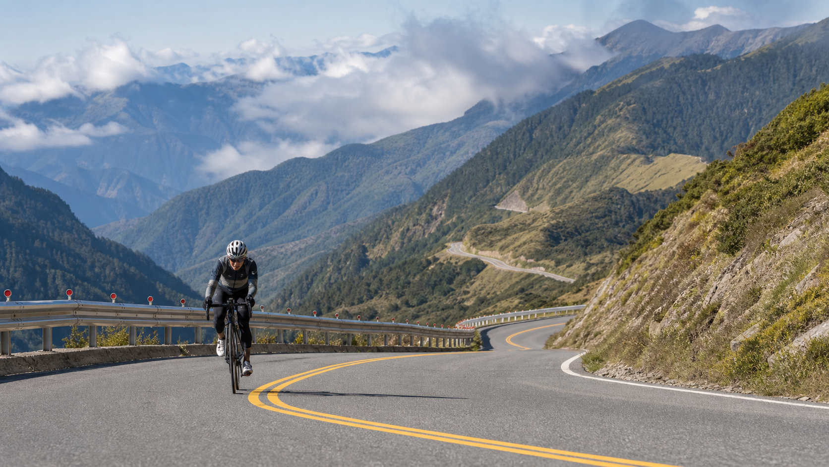
Northbound Wuling: Starting from Taiya Bridge, Another Wuling 113 Kilometers Away
Preface: Not Eastbound, but Northbound
In Taiwan’s road cycling circles, the word “Wuling” almost carries its own halo of sanctity. When most people hear Wuling, the image that comes to mind is the Pacific coastline of Qingshui Cliff in Hualien, climbing all the way from sea level to 3,275 meters on the Taiwan KOM Challenge—that eastbound route covered by countless international media outlets, a bucket-list pilgrimage for many road cycling enthusiasts.
But this time, I’m not talking about that route.
I’m talking about the “Northbound Wuling—Starting from Taiya Bridge”—a route that departs from the mountains of Yilan, heading in the complete opposite direction from the eastbound route, with a completely different path. 113.91 kilometers, 3,926.8 meters of total elevation gain, starting at Taiya Bridge. The name itself carries a story: Taiya (Atayal) is one of Taiwan’s indigenous peoples, and the Datong Township and Nanshan area of Yilan sit at the heart of the Atayal people’s traditional territory. When I first saw this name in a route database, I knew this wouldn’t just be a journey about climbing data—it would be a journey about land, people, and direction.
Before I start writing, I want to be honest and clear: this article is not meant to replicate a pilgrimage account of the eastbound Taiwan KOM Challenge, nor is it meant to imply that this northbound route is the route of that internationally renowned event. They are two completely different roads—different directions, different starting points, different terrain rhythms. The only thing they share is the finish line—Wuling, the highest point of Taiwan’s road system, at 3,275 meters above sea level, located in the Hehuan Mountain area on the border of Nantou and Hualien. In what follows, I will describe this northbound route as honestly as I can, based on what I know and what I felt. Where I encounter details I cannot confirm, I will frankly say “I’m not sure,” rather than fabricating a path just to make the story more complete.
The Weight of Wuling: The Sacred Mountain in the Hearts of Taiwan’s Road Cycling Enthusiasts
To understand what the Northbound Wuling route means to riders, you first need to understand Wuling’s place in Taiwan’s road cycling culture.
Wuling is not just an elevation number; it is a symbol. At 3,275 meters, it is the highest point reachable by any paved road in Taiwan. Roads higher than that exist only in a few high-mountain forest roads or trail systems, and those are generally not routes where road bikes can legally and safely travel. Therefore, for Taiwan’s road cycling community, Wuling plays a spiritual role similar to classic high-mountain stages in European cycling (such as the Col du Tourmalet in the Tour de France)—it is a “have you ridden Wuling yet?” credential, an ultimate goal that any rider who takes climbing challenges seriously will eventually want to conquer in person.
Among the many possible approaches to Wuling, the eastbound route—the one used by the Taiwan KOM Challenge—is undoubtedly the most famous, with the most participants and the greatest media exposure. Every year during the event, professional riders and amateur enthusiasts from around the world gather in Hualien, starting from Qingshui Cliff on the Pacific coast, and spend an entire day pedaling the vertical distance from sea level to 3,275 meters, step by step. The fame of this route has, to some extent, made “Wuling,” “eastbound,” and “Taiwan KOM” nearly synonymous in many riders’ minds.
But Wuling has never been reachable by only one road. As a key node in the Central Mountain Range, the Hehuan Mountain area has multiple access points from various directions in its surrounding road network—they just lack the fame and participation numbers of the eastbound route. The northbound route is exactly such a path: relatively low-profile, yet equally real, and requiring equally tremendous effort to complete. It departs from Yilan, traversing a completely different geographic texture and cultural context, and ultimately arrives at the same Wuling archway through different means.
I think this is precisely what makes the Northbound Wuling route so fascinating—it means that “conquering Wuling” no longer has just one standard answer, one path locked in the media spotlight. It opens up another possibility: from a direction you wouldn’t expect, at a pace you wouldn’t expect, you can still reach that highest point of Taiwan’s roads. Moreover, with a total length of 113.91 kilometers and 3,926.8 meters of total elevation gain, this route is in fact longer and has more climbing than the eastbound route—it just remains relatively invisible in terms of fame.
The Meaning of the Starting Point: Taiya Bridge and the Ethnic Memory of the Yilan Mountains
The name of the starting point, “Taiya Bridge,” is itself worth pausing to consider.
The Atayal people are one of Taiwan’s indigenous groups with a wide distribution, their traditional territory spanning multiple mountainous counties in northern Taiwan. The Nanshan and Siji communities in the Datong Township area of Yilan are important Atayal settlements in the Yilan region. This mountain area has long been the traditional territory where the Atayal people lived, farmed, and hunted. Every stream and every ridgeline in these mountains may carry geographic knowledge and cultural significance for the Atayal that differs from the modern road system.
When I learned that the starting point of this route is “Taiya Bridge,” what surfaced in my mind was not just a geographic coordinate, but a reminder—a reminder that this mountain area has never been a “blank wilderness” waiting to be crossed by a road system, but rather a land already imbued with profound cultural meaning. As I prepared to push down on the pedals, pursuing personal physical breakthroughs and the sense of achievement from a challenge, I also reminded myself to complete this journey with respect for this land and for the Atayal people who have lived here for generations.
I must honestly admit that I do not have one hundred percent certain first-hand information about exactly which communities this route passes through or the precise place-name transitions along the way. I am unwilling to fabricate specific route details or mileage figures just to make the story read more richly. What I can honestly share is this overall impression: this northbound route roughly follows the road system of the Yilan mountains, starting from the relatively low-elevation area around Taiya Bridge, gradually advancing into the high mountains, and finally climbing to Wuling. The areas it passes through belong to the geographic overlap between the Yilan mountains and the Atayal traditional territory—this is background knowledge I can confirm and am willing to honestly share.
If you are a rider who, like me, was drawn to this route by its name and decided to take on the challenge, I would suggest that beyond focusing on fitness data and climbing strategy, you might also spend some time getting to know the Atayal culture and history behind this mountain area—so that this ride becomes not just a physical challenge, but also an opportunity to understand and pay tribute to Taiwan’s diverse ethnic cultures.
From Lowlands to the Clouds: The Layered Transitions of Ecological Zones
113.91 kilometers, 3,926.8 meters of total elevation gain—this combination of numbers guarantees that the journey will pass through an extraordinarily rich sequence of ecological zones. This is one of the most fascinating aspects of long-distance high-mountain routes, yet also the one most easily overlooked by purely data-driven planning.
At the start, the low-elevation mountain area around Taiya Bridge in Yilan is warm and humid, typical of subtropical low-elevation forest ecology. Along the way, farmland, orchards, and low-elevation broadleaf forests may alternate, with the air carrying the distinctive moist quality of the Yilan mountains. The riding sensation at this stage is one of the body gradually warming up and muscles easing into their rhythm, with the surrounding greenery still carrying the dense vitality of the lowlands.
As elevation gradually rises into the mid-elevation mountains, the vegetation begins to show clear changes. The dense broadleaf forests gradually give way to mixed coniferous and broadleaf stands, temperatures cool with the rising altitude, and the air becomes thinner and crisper. The riding sensation at this stage is when the body begins to realize “this is not an ordinary ride”—breathing becomes more labored, and even maintaining the same power output produces a noticeably higher subjective sense of fatigue. This is the concrete manifestation of altitude’s effect on human physiology.
And as the route continues pushing toward the high-mountain core, finally approaching the high-elevation zone around Wuling, the landscape transforms into the typical high-mountain vegetation belt of Taiwan—coniferous forests gradually thin out, arrow bamboo slopes and alpine shrubs become the protagonists of the view, and the air becomes so thin that even breathing feels noticeably different. At this stage, every pedal stroke feels like fighting against the double assault of gravity and oxygen deprivation. Yet at the same time, the open high-mountain vistas ahead and the layered ridgelines of distant peaks bring an unprecedented sense of grandeur—a visual and psychological impact that low-elevation riding can never provide.
This continuous transition from the muggy, humid lowlands to the thin, crisp high mountains, compressed into a single day of riding, is in some ways the very heart of what makes climbing Wuling so captivating—you are not just gaining elevation; you are, with your own legs, personally experiencing a vertical ecological journey from the subtropics to the alpine zone. This is a profound sensation that no form of motorized transport can truly convey. Only by relying on your own power, inch by inch, carrying your body from the lowlands to the clouds, can you truly understand the weight of this transformation.
First Person: The Psychological Ups and Downs of 113 Kilometers
I want to take a longer passage to honestly describe the psychological journey this long-distance challenge brought me, because I believe that compared to mere scenery descriptions, this kind of authentic record of the inner experience may better convey the true nature of this route’s challenge.
On the morning of departure, the air around Taiya Bridge still carried the coolness of night. Dawn was just breaking. After checking my equipment and confirming my supplies, I mounted my bike, my mind a mix of excitement and a hint of uncertain apprehension. 113.91 kilometers, 3,926.8 meters of total elevation gain—with these numbers in my head, rationally I knew this would be a long journey, but emotionally, I still underestimated the psychological toll it would truly exact.
The low-elevation section at the start genuinely felt easy, even carrying a pleasant, almost picnic-like joy. In the early morning Yilan mountains, the air was fresh, and the greenery along the way relaxed my mood. For a moment, I felt this pace could be maintained for a long time. But I knew very well that this “feeling good” phase is precisely when it’s easiest to fall into the pacing trap—if you unconsciously speed up because it feels easy, the tens of kilometers and thousands of meters of climbing ahead will exact double the price. I deliberately suppressed that urge to accelerate, reminding myself that this was only the beginning of a 113-kilometer journey.
Once I entered the core climbing section in the middle segment, things began to change. The rising altitude made breathing more labored, and the undulating gradients forced the body to constantly switch rhythm between climbs and brief respites. This stage was when my psychological state was most prone to fluctuation—physical exhaustion was accumulating, yet the finish line at Wuling still felt impossibly far away. That psychological gap of “I’ve already ridden so long, yet there’s still so far to go” is the most real and hardest-to-endure part of any long-distance high-mountain challenge. I remember repeatedly calculating in my head how many kilometers I’d covered and how much climbing remained. In a way, this calculation itself was a psychological mechanism for alleviating anxiety.
As the elevation continued to rise into the high-mountain core near Wuling, the fatigue in my body began to intertwine with the physiological effects of altitude hypoxia, becoming a more complex, more all-encompassing exhaustion. At this stage, I began to rely more heavily on psychological support—recalling why I chose to take on this route, imagining the scene of arriving at the Wuling archway, telling myself that every rotation of the pedals brought me closer to the finish. This almost self-dialoguing psychological adjustment was the key force that carried me through the final difficult stretches.
And when the Wuling archway truly appeared in my field of vision, I must honestly say that the surge of emotion far exceeded what I had anticipated. It wasn’t just the sense of accomplishment from completing a 113-kilometer challenge; it was a complex emotion—a release after physical depletion, a respect for this land and its history, and a renewed recognition of my own willpower, all mixed together. Standing at 3,275 meters, gazing at the layered mountain ranges in the distance, I thought of the warm air around Taiya Bridge at the start, of the anxiety of not seeing the end during the middle climbs, of the layered transitions of ecological landscapes along the way—all these fragments, at the moment of arrival, seemed to connect into a complete narrative, giving me a profoundly different and deeper personal understanding of the word “Wuling” than when I had merely known the eastbound event through media coverage.
The Symbolic Meaning of Wuling for Road Cycling Enthusiasts
After experiencing this northbound challenge, I have developed a more three-dimensional understanding of Wuling.
For Taiwan’s road cycling enthusiasts, Wuling has never been just a geographic coordinate; it is more like a spiritual totem—representing the ultimate symbol of long-distance, high-intensity climbing challenges. The reason the eastbound Taiwan KOM Challenge has become an internationally renowned event is not just its organization and marketing, but more importantly, the extreme narrative tension of “from sea level to the highest point of Taiwan’s roads” that it represents. This vertical span from sea to mountain, from 0 to 3,275 meters, inherently carries powerful storytelling and communicative force.
But what I want to say is that the meaning of Wuling should not be monopolized by a single path. The northbound route—113.91 kilometers with 3,926.8 meters of climbing—interprets the hardship and value of climbing Wuling in its own way, and in fact surpasses the eastbound route in total distance and total elevation gain. It may not have the international fame and event prestige of the eastbound route, but for riders willing to personally ride this road, the sense of achievement from conquering it and the profound experience of dialogue with the land and history are in no way diminished by its lower profile. In fact, precisely because it is relatively low-key and less traveled, it carries an additional, uniquely personal joy of exploration and discovery.
I’ve begun to feel that perhaps our imagination of Wuling can be more expansive. It doesn’t have to have only one standard-answer pilgrimage path; it can be pluralistic—a shared destination reachable from different directions, at different paces, carrying different geographic and cultural contexts. Every road leading to Wuling tells, in its own way, the geographic diversity and cultural depth of this land of Taiwan.
Season-Limited Scenery and Reasons to Return
Although I cannot precisely describe the landmarks at every turn of this northbound route, I can honestly share the seasonal scenery impressions this journey gave me, and why I believe this is a route worth visiting repeatedly.
Because the route spans a huge vertical gap from Yilan’s low elevations to Wuling’s high elevations, visiting in different seasons brings completely different visual and physical experiences. In spring and autumn, the climate is relatively stable, and the layering from fresh greenery at low elevations to clear skies at high elevations is especially distinct—these are relatively suitable seasons for a first attempt at this route.
Visiting in summer, the muggy humidity of the low-elevation sections contrasts sharply with the coolness of the high elevations. This temperature difference itself is a unique physical journey, but it also requires more careful management of the risk of afternoon convective rainfall in the mountains. In winter, the high-elevation zone around Wuling may experience low temperatures, cloud and fog, or even brief snowfall due to the northeast monsoon and strong cold air masses. If you can visit under safe conditions, the image of summiting in the cold wind accompanied by a sea of clouds is one of the most unforgettable season-limited scenes this route has to offer—but safety must always be the top priority, and you must never recklessly attempt it in severe weather.
Precisely because of this ever-changing seasonal layering of scenery, I believe the Northbound Wuling route is absolutely worth visiting repeatedly. Each challenge may bring a completely different experience and insight, depending on the season, the weather, or even your own psychological state at the time.
Side Trip Suggestions: Extending the Challenge into a Deep Journey
If you plan to take on this Northbound Wuling route, I would suggest considering it not just as a single-day round-trip physical challenge, but as a deep journey combining local culture and natural scenery.
Before departure, you can arrange time to linger in the Datong Township area of Yilan, getting to know the local Atayal culture and way of life. The cultural depth of this land is absolutely worth riders taking time to understand, rather than treating it merely as a cycling backdrop. After completing the challenge and arriving at Wuling, the Hehuan Mountain area itself is an important hub for Taiwan’s high-mountain ecotourism. If your energy and schedule permit, consider staying a while in the nearby high-mountain areas to appreciate the unique alpine ecology and the magnificent mountain vistas, so that the rewards of this journey extend beyond the sense of accomplishment from completing a route, deepening into a richer understanding of Taiwan’s high-mountain ecology and culture.
Since the total distance and total elevation gain of this route are both considerable, I also recommend treating it as a journey requiring advance planning for accommodation and transportation connections, rather than a challenge you can undertake on a whim. Many riders choose to stay overnight in the Yilan mountain area the night before, allowing their bodies to acclimate to the local climate and altitude environment in advance, then depart the next morning with more adequate sleep and physical condition. This arrangement can, to some extent, reduce the risks associated with fatigue and sleep deprivation during a long high-mountain challenge. And after completing the challenge and arriving at Wuling, if your descent route and transportation connections are well planned, consider giving yourself some buffer time to let your body and mind gradually recover from the high-intensity challenge, rather than rushing back and missing the moment you should reserve for properly digesting this journey.
The Meaning of Sharing with Fellow Riders: One Route, Stories Told Differently
In recent years, I’ve gradually come to appreciate that a relatively low-profile yet equally solid challenge route like Northbound Wuling deserves to be known by more people, not just because its data is hardcore and challenging enough, but because it offers a narrative possibility completely different from the eastbound Taiwan KOM Challenge.
The eastbound route, due to its event-based, international nature, has to some extent formed a relatively fixed collective narrative—the magnificent starting point at Qingshui Cliff, the awe-inspiring craftsmanship of Taroko Gorge, the final trial at Dayuling. These images and stories, through media and participant sharing, have become deeply etched in many people’s minds, forming an almost “standard version” of the Wuling story.
Northbound Wuling, precisely because it is relatively little known and lacks systematic reporting and sharing, instead gives every challenger the opportunity to construct their own Wuling narrative in their own way. The clouds and mist you see, the temperature differences you feel, the thoughts that cross your mind during the middle climbs, your understanding and imagination of Atayal culture—all of these vary from person to person, with no “standard answer” waiting for you to compare against and verify. This openness of narrative, in a sense, gives Northbound Wuling an additional precious value of personal exploration compared to the highly symbolized eastbound route.
I also want to take this opportunity to encourage fellow riders who have ridden this route to share their real experiences and feelings more often—whether it’s fitness data, gear insights, or narrative angles like mine that focus on psychological journeys and cultural background. All of these can enrich this route’s collective memory within Taiwan’s road cycling community. After all, the meaning of a route can never be fully interpreted by geographic data alone; it requires generation after generation of riders’ first-hand experiences and sincere sharing to gradually accumulate its own cultural depth, just as the eastbound route has accumulated its rich narrative through years of event exposure. Northbound Wuling may well be standing at just such a starting point, waiting to be written about by more people and filled with more stories.
Conclusion: Your Own Wuling
Back to the initial reminder: this “Northbound Wuling—Starting from Taiya Bridge” is not the eastbound Taiwan KOM Challenge event. It is an independent route with a different direction, a different starting point, and a different rhythm, yet it leads to the same highest point of Taiwan’s roads. 113.91 kilometers of distance, 3,926.8 meters of total elevation gain—behind these numbers lies a complete journey that crosses ecological zones, carries the cultural memory of the Atayal traditional territory, and tests both physical endurance and psychological resilience.
For me, the meaning of this ride far exceeds the sense of accomplishment from “completing a high-difficulty route.” It made me rethink that Wuling, this sacred mountain in the hearts of Taiwan’s road cycling enthusiasts, doesn’t have to have only one way of arrival locked in the media spotlight. Starting from Yilan, starting from Taiya Bridge, at your own pace, in your own way, you can equally reach that highest point at 3,275 meters—and the scenery and psychological experience this path brings belong uniquely and irreplaceably to every rider willing to personally ride this road.
If you have ever yearned for the eastbound Taiwan KOM Challenge, yet also long for a route that is your own, relatively low-profile yet equally solid, perhaps Northbound Wuling is the next goal worth seriously planning.
Related Reading
- Northbound Wuling 113km Full Analysis: The Hidden Wuling Challenge from Taiya Bridge—Fiercer or Gentler Than the Eastbound Route?
- Taiwan Mountain Cycling Culture: The Collective Ritual of Riding Wuling
- Wuling Climbing Guide: Challenge Strategies and Supply Planning for Taiwan’s Highest Road
- Eastbound vs. Westbound Wuling: A Full Comparison of Difficulty, Scenery, and Soul of the Two Routes
#北橫 + #北進武嶺 最硬的員工旅遊 EP1 | #公路車 #拉拉山 | 明池 | 武嶺 | 武陵農場 | 雲海 | Taiwan Cycling Route Wulin
6 年前
大禹嶺 到 武嶺牌樓 全程前後實況錄影 | 北進武嶺 | 東進武嶺 | KOM | 訓練台 | 坡度分析 | Taiwan KOM Last 10 km HARD | 公路車
6 年前
台灣登山王之路 KOM 全程參賽4K臨空錄影 PART1 穿越峽谷地形! #東進武嶺 太魯閣 / 燕子口 / 天祥 / 西寶 PART1 (公路車 / CT Yeh)
3 年前
2023 夏季KOM 參賽實況 / 穿越空拍視角 / 整車都凸台 / 太魯閣峽谷x合歡山絕美大景 / 東進武嶺 / Taiwan KOM Challenge / 公路車 / CT Yeh
3 年前
西進武嶺 世界紀錄挑戰!破2:30 ?!一群人推著一個夢上山 直播精華版 / ft. 張翰允 & 台視主播魏于恬 & KPLUS / #cycling 公路車 CT Yeh
2 個月前
台北闊瀨陡坡 騎旅 / 日本單車雜誌編輯車友臨時加入!/ 髮香才是最強的 / feat. 北迴歸線小隊 / 公路車 CT Yeh
6 個月前
大武山20%魔王陡坡【JJSC南台灣遊騎Day2】!屁股真的要裂開了...凡士林抹滿也沒用?神秘金教堂還有超便宜夜市
3 個月前
嘉義大埔、阿婆灣挑戰賽,美到以為在日本!ft. 環騎5 Cool 西拉雅188 / 公路車 / CT Yeh
7 個月前