Southern Cross-Island Highway Westbound: A Cycling Memory of Resilience, Bunun Mountain Forests, and a Cloudtop Lake from Meishankou to Tianchi
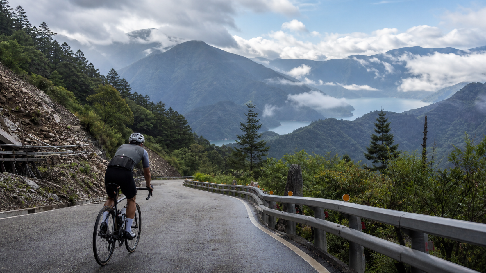
Some roads, once ridden, stay with you for a lifetime. The Southern Cross-Island Highway heading west, from Meishankou to Tianchi—25 kilometers, 1,477 meters of climbing. This piece isn’t about pacing or power numbers; it’s about the story of this road—the scars it bears, the people it carries, and the feeling of slowly grinding upward with one bike and two legs.
A Road That Crosses the Spine of Taiwan
The Southern Cross-Island Highway, officially designated Provincial Highway 20, is one of Taiwan’s three major cross-island highways, alongside the Central Cross-Island Highway to the north and the New Central Cross-Island Highway slightly to the south. It begins in Yujing, Tainan, in the west, and winds eastward through Taoyuan and Meishan in Kaohsiung, crossing the Yako Pass in the southern Central Mountain Range, before finally reaching Haiduan, Taitung—linking western and eastern Taiwan with a winding ribbon of asphalt.
The significance of this road goes far beyond being “just a highway.” The Central Mountain Range is Taiwan’s backbone, the most important watershed shaping the island’s terrain and climate—rain in the west flows west, rain in the east flows east—and the Southern Cross-Island Highway is one of the few land routes that truly crosses this spine, connecting the two sides of Taiwan. Driving or cycling the highway, you feel the weight of the phrase “crossing mountains and ridges” in a visceral way—not as a metaphor, but as a physical experience of climbing over a thousand meters, passing through cloud belts, and sensing the shift between climate zones.
Meishankou is a key node on the western section of the highway. At an elevation of around 1,000 meters, it has long been home to an important control station and visitor center, and serves as the launching point for many westward challengers. Past Meishankou, the road truly begins to climb, with scenery transitioning from river-valley terrain to high-mountain forest. The endpoint, Tianchi, sits at roughly 2,700 meters above sea level and is one of the most iconic high-mountain lake landscapes along the highway, its waters appearing and disappearing in the mountain mist—for many, “the most beautiful stretch of the Southern Cross-Island Highway.”
For cyclists, completing this road with your own legs is an entirely different level of experience compared to passing through by car. A car merely moves you; climbing on a bike is a long dialogue between body and terrain—you remember every gradient change through the ache in your thighs, every gain in elevation through the rhythm of your breath. These memories are etched deeper than any photograph.
The Bunun’s Mountains, the Bunun’s Road
To speak of the Southern Cross-Island Highway, one cannot ignore the true masters of these forests—the Bunun people. Taoyuan District is one of the main Bunun settlements in Kaohsiung City, and this expanse of mountain forest across the southern Central Mountain Range has been the heart of the Bunun’s traditional territory for centuries.
The Bunun are among Taiwan’s indigenous peoples whose traditional range reached the highest elevations and penetrated deepest into the Central Mountain Range. Their hunting grounds, farming plots, and migration routes overlap profoundly with the path later taken by the Southern Cross-Island Highway. The road we climb today on modern asphalt with our bikes was, in earlier times, a way of life carved out by the Bunun on foot, through their deep understanding of the mountains.
When we pass through this land as travelers and sports enthusiasts, it’s worth slowing down and approaching with respect—this is not merely a “scenic climbing route,” but a land rich with cultural context and historical memory. The tribal communities along the way are places where the Bunun have lived and sustained their culture for generations, not backdrops for tourism. The Bunun’s renowned rituals such as the “Ceremony of the Hunting Gun” and the “Ear-Shooting Festival,” along with their unique eight-part polyphonic singing, are living cultural forces that have endured on this land—not curiosities to be consumed, but living culture worthy of understanding and respect.
When riding through tribal sections, slow down and be courteous. If you happen to meet local residents, a smile or a greeting will let you feel the warmth of this land more than any guide article could. The fact that this road exists, that we have the chance to experience the grandeur of the Central Mountain Range on two wheels, stands in some measure on the shoulders of this land’s long history.
Scars and Rebuilding: The Southern Cross-Island Highway After Typhoon Morakot
Looking only at today’s green mountains and clear waters along the route, it’s easy to forget that the Southern Cross-Island Highway is a road deeply scarred, yet stubbornly reborn.
In 2009, Typhoon Morakot (commonly known as the 88 Flood Disaster) devastated Taiwan’s central and southern mountain regions, bringing record-breaking rainfall. Large sections of the Southern Cross-Island Highway suffered massive landslides, with washed-out roadbeds and destroyed bridges—the damage so severe that many doubted the road could ever be restored. This disaster didn’t just cripple a highway; it profoundly altered the lives of the tribes and residents along the route. Many communities were forced to relocate or rebuild, and that period was an extremely difficult time for Taoyuan District and everyone along the highway.
After the disaster, road authorities undertook long-term repair and reconstruction efforts. The mountain geology was already fragile, and with typhoons and torrential rains striking year after year, every reopening was never a “fix it once and for all” affair—it required continuous monitoring and ongoing reinforcement. This is why the western section’s accessibility has fluctuated through closures, emergency reopenings, and controlled access over the years—not a matter of administrative inefficiency, but a true reflection of the ongoing tug-of-war between mountain geology and extreme weather.
From one perspective, the reconstruction history of the Southern Cross-Island Highway is a microcosm of Taiwan’s relationship with its mountains. We long to get close to the high peaks, to measure this magnificent terrain with our feet and wheels, yet we must also humbly acknowledge that this land has a temper of its own—mountains collapse, roads break, and human engineering remains limited in the face of extreme weather. Behind every reopening are countless engineers and maintenance workers quietly laboring in harsh conditions over the years.
It is precisely for this reason that when we have the chance to ride this road today, seeing the restored pavement and sturdy slope-retention works, we should carry a sense of gratitude—gratitude for those who have devoted their efforts to safeguarding this road over the years, and a reminder to respect the current access regulations. The opening and closing of the road often hinge on professional geological and safety assessments—not arbitrary rules to be challenged on a whim, but lessons earned through blood and tears. Any rider preparing to take on this route must check the latest announcements from the road authority before setting out, confirming the actual access status, whether permits are required, and whether there are time restrictions. This is both a responsibility to your own safety and a mark of respect for this hard-won road to recovery.
First Person: 25 Kilometers from River Valley to Cloud
In the early morning at Meishankou, the air still carries a hint of chill. I slot the water bottle into the cage, check the tire pressure, take a deep breath, and get ready to depart. The number 25 kilometers is written in my mind, but the moment you actually push down on the first pedal stroke, you understand that numbers and physical sensation are two completely different things.
For the first few kilometers of the climb, the road winds along the river valley, flanked by layered mountain ridges. Morning light hasn’t yet fully spilled into the valley, and the air carries a weight of stillness. The gradient on this stretch is still relatively gentle; my heart rate gradually syncs with cadence, the body slowly settles into its rhythm, and aside from the tempo of my breathing, there’s room in my head to take in the surroundings—the sound of the stream flowing through the valley, the occasional birdcall, and the steady, reassuring feel of the asphalt beneath the tires.
Around one-third of the way up, the gradient begins to bite noticeably, and one switchback after another appears in succession. This is where physical strength and willpower truly begin to be tested. The burning sensation in the thighs stacks higher with each pitch, breathing grows heavier, and after every corner, I have to convince myself, “Just hold on for one more turn.” At moments like this, looking up at the scenery around you is actually the best psychological reset—you realize you’ve already climbed far higher than where you started, and the road behind has become a thin thread winding below your feet. This visual sense of accomplishment is a crucial force that keeps you pushing upward.
Past the midpoint, the vegetation begins to shift subtly. The dense broadleaf forest gradually gives way to upright conifers, and the air, drop by drop, becomes thinner and crisper. This transition doesn’t happen suddenly; it unfolds like a cinematic dissolve—so gradual it’s almost imperceptible—until at some moment, you suddenly realize the forest around you has changed its face entirely, the temperature is several degrees cooler than down below, and the sweat on your forehead turns to a chill as the mountain breeze sweeps across it.
The final few kilometers are the domain of willpower. The body is already quite fatigued, and the slight sense of oxygen deprivation at altitude makes every breath feel like it can’t quite fill the lungs. At this point, all you can do is narrow your focus to something very, very small—not thinking about how many kilometers remain, only concentrating on this one pedal stroke, this one breath. The mountain wind begins to howl past your ears, and mist occasionally drifts across your vision, bringing a nearly surreal sense of stillness.
Finally, Tianchi arrives. That high-mountain lake lies quietly cradled in the embrace of the surrounding peaks, its surface reflecting the sky and drifting clouds, so serene it almost makes you forget the fierce physical struggle you just endured. I park the bike, pull off my gloves, and only then truly realize—my legs are still trembling slightly, but the sense of fulfillment in my heart far outweighs the body’s exhaustion. This feeling of fatigue and satisfaction intertwined is precisely what makes long climbs so captivating and so addictive.
Scenery Along the Way: From River Valley to High-Altitude Coniferous Forest
A large part of the charm of these 25 kilometers on the western section of the Southern Cross-Island Highway comes from the diversity of landscapes it presents within such a short distance—something rarely seen among Taiwan’s road cycling routes.
The starting point around Meishankou is typical mountain river-valley terrain, with steep slopes on both sides and a stream carving deep topography through the valley floor. This kind of terrain carries an inherently primitive and majestic beauty. As elevation gradually rises, you pass through the broadleaf forests common to Taiwan’s mid- and low-elevation mountains—rich in species, dense in canopy, lush and green in summer, offering a relatively cool riding environment.
Riding past the middle section, as elevation continues to climb, the vegetation begins to show transitional characteristics—broadleaf species start to thin out, and mixed coniferous-broadleaf forests become the norm. This stretch is what many riders describe as “the most visually rewarding section,” because you can see plant communities from different elevation bands coexisting in a single, unique landscape.
Higher still, on the approach to Tianchi, the road enters Taiwan’s typical high-mountain coniferous forest belt. Towering conifers and crisp, clean air, paired with the occasional drifting mist, create an atmosphere that feels almost detached from the mundane world. This complete landscape transformation—from river valley to high-mountain forest—compressed into just 25 kilometers, is what makes the western section of the Southern Cross-Island Highway so unique and so worth experiencing slowly by bike. If you passed through by car, this gradual shift in scenery would be easy to miss, but climbing it leg by leg, you feel every single moment of transition.
Seasonal Advice and Riding Timing
The experience of riding a high-mountain route is inseparable from season and weather; choosing the right time to set out can dramatically enhance the entire journey.
Generally speaking, late spring and autumn are relatively stable periods for Taiwan’s mid- and high-elevation mountain areas. The likelihood and intensity of afternoon convective showers are lower, visibility is generally better, and these are the preferred seasons for many long-climb enthusiasts. Summer, while offering cooler mountain temperatures and a pleasant escape from the lowland heat, carries a higher risk of afternoon thunderstorms and lightning strikes in Taiwan. It’s advisable to set off in the early morning and aim to complete the main climbing sections before the typical afternoon thunderstorm window. In winter, special attention must be paid to possible low temperatures and even icy conditions at high elevations; warm gear and pre-ride weather checks are especially important.
Regardless of which season you choose, mountain weather is notoriously fickle. Be sure to check the latest weather forecasts and mountain-specific advisories before departure. Also, as noted earlier, the actual traffic-control status of the western section of the Southern Cross-Island Highway has changed multiple times over the years. Beyond seasonal weather-risk assessment, whether the road itself is open remains the single most important thing to confirm when planning this journey.
The High-Mountain Lake: The Serenity and Legends of Tianchi
Tianchi—the name itself carries a poetic quality. Located near the Yakou (Pass) of the Southern Cross-Island Highway at an elevation of roughly 2,700 meters, it is one of the most iconic high-mountain lake landscapes along the entire route. Unlike the orderly, planned feel of lowland reservoirs or artificial lakes, Tianchi’s water sits quietly embedded among the peaks, surrounded by coniferous forest and exposed rock faces. Mist frequently hangs low, moisture-laden air shrouds the area, and the entire lake basin exudes a transcendent stillness.
Many locals and hikers who have traveled the Southern Cross-Island Highway for years hold a special affection for Tianchi. It is more than just a scenic spot—it feels like the spiritual endpoint of this arduous journey. When you’ve spent your strength, endured the thin air at altitude, and pedaled through all 25 kilometers one pitch at a time, suddenly coming upon such a tranquil high-mountain lake creates a visual and psychological contrast that can instantly transform exhaustion into an indescribable sense of wonder. The water reflects the sky and drifting clouds; occasionally a mountain breeze sweeps across, stirring faint ripples, as if silently telling of these mountains and forests that remain serene through wind and storm.
For riders, Tianchi is also a reminder—a reminder to slow down and truly savor the destination of this journey, rather than rushing to turn around and descend or retrace your route. Find a sheltered spot, sit down, take in some calories and fluids, let your body gradually recover from the high-intensity climb, and at the same time, let your eyes and your heart properly receive the gift this landscape offers. Many riders say there are a few moments in life that are etched into memory with particular depth—and standing at the edge of Tianchi, legs still trembling, gazing at that quiet expanse of water, is often one of them.
Mental Preparation for First-Time Challengers
Compared to equipment and physical fitness, the psychological preparation for tackling a long high-mountain climb like the western approach to the Southern Cross-Island Highway for the first time is often overlooked—yet it is just as important.
What truly tests you on a long climb is not the peak effort of any single moment, but sustained endurance and willpower over a long period. During the ride, thoughts of “why am I putting myself through this” are almost guaranteed to surface—especially during the third section of continuous switchbacks or the fifth section’s hard grind before the pass, when the pain is relentless and the end seems nowhere in sight. This psychological low point is a shared experience among nearly every long-climb enthusiast. What matters is being mentally prepared to know that this is normal, not a sign that you’re especially fragile or underprepared.
Experienced riders typically advise breaking the entire journey down into a series of small goals in your mind, rather than fixating on daunting numbers like “how many kilometers are left.” Tell yourself, “just ride to the next corner,” “just get through this steep stretch,” and use a chain of achievable mini-goals to steadily accumulate a sense of accomplishment that carries you through to the end. This mental decomposition technique is essentially the same principle as the six-stage segment strategy mentioned earlier—breaking something that seems vast and difficult into a series of concrete, manageable steps.
Additionally, giving yourself permission to stop and rest when necessary is important mental groundwork. For a first attempt at this level of route, there’s no need to cling to the unnecessary insistence of “never stopping midway.” Pausing to catch your breath, hydrate, and take in the scenery actually makes the entire experience more complete and safer. After all, the true value of this route has never been about how fast you complete it, but about how much preparation and patience you’re willing to invest for a goal, and the understanding you ultimately gain by completing it with your own two legs.
The Meaning of This Road for Riders
After riding the western approach of the Southern Cross-Island Highway from Meishan to Tianchi, many people will say it is a feeling that is difficult to describe in words. It is not just completing a physical challenge; it feels more like completing a deep dialogue with this land and its history.
What this road carries is more than just numbers of gradient and elevation. It is the mountain forest where the Bunun people have lived for generations, a testament to the scars and reconstruction left by Typhoon Morakot, and the result of countless engineers and maintenance workers who have quietly dedicated themselves to protecting it over the years. When you use your own legs to pedal through those 25 kilometers, section by section, you are actually experiencing the grandeur of this island’s Central Mountain Range in the most intimate way possible—and, in a subtle sense, paying your respects to everything this land has been through.
For many long-distance climbing enthusiasts, the western approach of the Southern Cross-Island Highway is not just “a highly difficult route,” but a space for self-dialogue—in those moments when your physical strength is near its limit, your breathing is rapid, and your legs are aching, you are forced to confront your most authentic self. The willpower, patience, and resilience that are usually hidden beneath everyday life are gradually drawn out during such a long climb. This is also why, even knowing how tough and exhausting this road is, there is an endless stream of riders willing to challenge it again and again.
If you are also ready to take on this road, please remember to confirm the latest road access status and weather conditions before setting off, and ride with respect for this land, its history, and the Bunun culture along the way. When you finally reach Tianchi and gaze at the quiet alpine lake reflecting the sky above, you will understand that every gasp for breath, every bend, and every meter of elevation gained along the way was worth it.
Sharing with Fellow Riders: One Road, One Group of People
Long-distance alpine climbing is often not a solitary practice, but a collective memory built together by like-minded cycling companions. Routes like the western approach of the Southern Cross-Island Highway, precisely because of their high difficulty and the extensive preparation required, are especially suited for teams or groups of friends to support one another and take on the challenge together.
During the ride, encouragement from companions often has an unexpectedly powerful effect. When you feel your energy about to run out in the hard fight before the fifth section’s pass, a “Keep going, you’re almost there” from ahead or behind provides a psychological boost that is sometimes more effective than supplies themselves. Conversely, when you notice a companion struggling with the gradient or the high altitude, actively slowing down to keep them company, sharing a sip of water or a bite of an energy bar—these seemingly small gestures are often the warmest part of a long climb.
Many seasoned riders suggest that when tackling a route of this caliber for the first time, it is best to ride with experienced companions. On one hand, you can look out for each other’s safety; on the other, experienced riders can often inform you in advance about road conditions and what to expect physically, reducing the anxiety that comes from insufficient information when figuring things out alone. Of course, if you prefer to challenge yourself solo and enjoy the process of conversing with the mountain by yourself, that is another entirely different experience this route can offer—free from the rhythm of others, adjusting your pace entirely according to your body’s signals. This solitude, in a way, is also a means of understanding your own limits.
Whether completed as a group challenge or solo, gathering afterward to share thoughts and feelings with one another is often the most memorable part of the entire journey. Some will talk about the hairpin turns in the third section and the steep slopes that left a deep impression, others will share the emotion of arriving at Tianchi. These stories are passed down by word of mouth within the cycling community, becoming part of the route’s legendary character, and continue to draw wave after wave of riders to personally experience this magnificent journey across the spine of Taiwan.
Epilogue: The Road Remains, and the Story Continues
Having endured severe damage and a long restoration, the Southern Cross-Island Highway still lies quietly along the ridgeline of the southern Central Mountain Range today, waiting for every traveler and rider who comes with respect. It has witnessed the ruthlessness of typhoon disasters, and it has witnessed people’s relentless efforts to rebuild time and again; it carries the memories of generations of Bunun life, and it carries the love and reverence modern cycling enthusiasts hold for the mountains.
Every time someone completes the 25 kilometers from Meishan to Tianchi, in a sense, they are adding a new page to the story of this road. The meaning of this road has never been merely a route marked with gradient and distance on a map, but an ongoing story about people and land, about resilience and respect.
May you, after preparing everything and confirming the latest information, set out on this journey with humility and reverence, and at the moment you arrive at Tianchi, find your own sense of emotion and insight.
Related Reading
- Southern Cross-Island Highway Westbound Meishan to Tianchi Guide: Full Breakdown of Six Sections, Pacing, and Supplies for 25 km with 1,477 m of Climbing
- Southern Cross-Island Highway Tianchi to Yakou Section: A High Mountain Road Crossing the Central Mountain Range
- Taiwan Long-Distance Cycling Routes: Mountain Riding Exploration on the Southern Cross-Island Highway
- Southern Cross-Island Highway Eastbound: A Road Paved with Lives, a Cloudtop Pilgrimage After Thirteen Years of Closure
#北橫 + #北進武嶺 最硬的員工旅遊 EP1 | #公路車 #拉拉山 | 明池 | 武嶺 | 武陵農場 | 雲海 | Taiwan Cycling Route Wulin
6 年前
大武山20%魔王陡坡【JJSC南台灣遊騎Day2】!屁股真的要裂開了...凡士林抹滿也沒用?神秘金教堂還有超便宜夜市
3 個月前
嘉義大埔、阿婆灣挑戰賽,美到以為在日本!ft. 環騎5 Cool 西拉雅188 / 公路車 / CT Yeh
7 個月前
大武山後門26%歡樂陡坡!JJSC南台灣單車行Day2 / 被颱風追著跑 / 公路車 / CT Yeh
2 年前
半日 小台灣 極限單車路線挑戰實錄
7 年前
台灣登山王之路 KOM 全程參賽4K臨空錄影 PART1 穿越峽谷地形! #東進武嶺 太魯閣 / 燕子口 / 天祥 / 西寶 PART1 (公路車 / CT Yeh)
3 年前
2023 夏季KOM 參賽實況 / 穿越空拍視角 / 整車都凸台 / 太魯閣峽谷x合歡山絕美大景 / 東進武嶺 / Taiwan KOM Challenge / 公路車 / CT Yeh
3 年前
超激烈!2025 南庄仙山KOM 賽事精華 / 男菁英A x 女菁英A / 公路車 / CT Yeh
9 個月前