The Starting Point: Lixing End, a Name Easily Overlooked
If you mention “Hehuan Mountain” in the cycling community, what most people picture is probably the group photo in front of the Wuling archway that everyone takes, or the classic route winding up from Cingjing and Puli. But the name “Lixing End” is unfamiliar to many riders. It’s not the kind of name printed on tourist posters; rather, it belongs to another path—less talked about, yet equally leading to the same high-mountain sky.
Lixing—the name itself carries a simple, down-to-earth quality unique to mountain settlements. It is part of the industrial road network within the Central Cross-Island Highway system, connecting remote tribal villages with high-altitude agricultural areas. The regions along the route are largely traditional Atayal territory, including places like Cuiluan and Ruiyan. These village names carry histories far older than the road itself—long before modern asphalt was laid, these mountains were already home to generations of Atayal people who lived, migrated, farmed, and hunted here.
The route known as “The Final 14K of Hehuan Mountain via Lixing End,” as the name suggests, is the last stretch approaching the Hehuan Mountain highway system from the Lixing direction—14.29 kilometers, 940.2 meters of climbing, carrying riders from mid-elevation tribal agricultural zones all the way to the point in Taiwan’s road network closest to the sky. This way of naming the route reveals a particular romance inherent in Taiwan’s road cycling culture: it doesn’t define itself by the fame of its destination, but rather uses a ceremonial phrase like “the final few kilometers,” implying that this is a challenge worthy of being discussed on its own, worthy of being taken seriously.
I first heard about this route during a casual chat with fellow riders. Someone said that everyone has climbed Wuling, but few have truly ridden the final stretch from the Lixing side. That remark planted a seed in my mind—compared to the crowded popular routes, this relatively obscure yet equally demanding high-mountain challenge seemed closer to the original spirit of road cycling: not for the check-in, but for a dialogue with oneself and with the mountain.
The Central Cross-Island Highway System and the Geographic Context of Taroko
To understand the weight of the Lixing End road, you need to zoom out and look at the broader geographic and historical context in which it sits. Taiwan’s Central Cross-Island Highway system is a highly representative chapter in the island’s highway engineering history. This road network crosses the Central Mountain Range, connecting transportation between Taiwan’s east and west sides. It includes the main Central Cross-Island Highway we all know, as well as multiple branch and connecting roads leading to the Hehuan Mountain area. The Lixing Industrial Road is one of them, playing an important role in linking remote tribal villages with the high-mountain highway system.
Administratively, this entire region spans the border between Xiulin Township in Hualien County and Ren’ai Township in Nantou County, while also largely falling within the boundaries of Taroko National Park. Taroko National Park is world-renowned for its magnificent canyon terrain and rich high-mountain ecosystems—from low-elevation broadleaf forests, transitioning upward through coniferous forest belts, and finally reaching the alpine tundra landscapes above nearly 3,000 meters. This vertical ecological variation is one of the most fascinating and challenging characteristics of Taiwan’s high-mountain terrain.
Riding through such a landscape is, in a sense, like experiencing a condensed geography textbook firsthand through your feet and pedals. From slopes along the industrial road that may still bear traces of agricultural cultivation, gradually climbing into pristine forest, and then higher up, where vegetation becomes low and sparse and the air grows thinner—this gradual environmental transition is not something you can feel by speeding past in a car. Only through the most primitive mode of movement, climbing kilometer by kilometer, can you truly appreciate the invisible yet real boundary between altitude and ecology.
The name Xiulin Township itself also marks the deep connection between this land and the Truku people (and the broader Atayal ethnic group). When riding this route, if you can bring a bit more awareness and respect for the local history and culture, the journey’s meaning extends beyond a physical challenge—it becomes a firsthand understanding of Taiwan’s diverse landscape. The mountains have never been merely scenery; they are also living carriers of culture.
Scenery and Ecology Along the Way: A Visual Feast of Vertical Ascent
Perhaps the most captivating aspect of this route lies in its “verticality.” The 14.29-kilometer distance isn’t long, but the 940.2-meter climb means riders experience extremely significant vertical elevation changes over a relatively short horizontal distance—and this change is directly reflected in the scenery and ecological features along the way.
In the lower section of the route, where the landscape still bears the characteristics of tribal agricultural areas, you may see cultivation of high-mountain specialty crops, settlements built into the hillsides, and occasional glimpses of valley streams peeking out between winding mountain paths. This is a mountain landscape with human warmth—not pure wilderness, but terrain shaped by long-term coexistence and negotiation between people and nature.
As elevation gradually rises, the vegetation belts show clear transitions, shifting from broadleaf forests to coniferous forests, and the scent in the air subtly changes as well—that distinctive aroma mixing damp soil, pine needles, and crisp high-mountain air is, alongside visuals, the sensory memory most frequently mentioned by veteran riders when describing high-mountain cycling experiences.
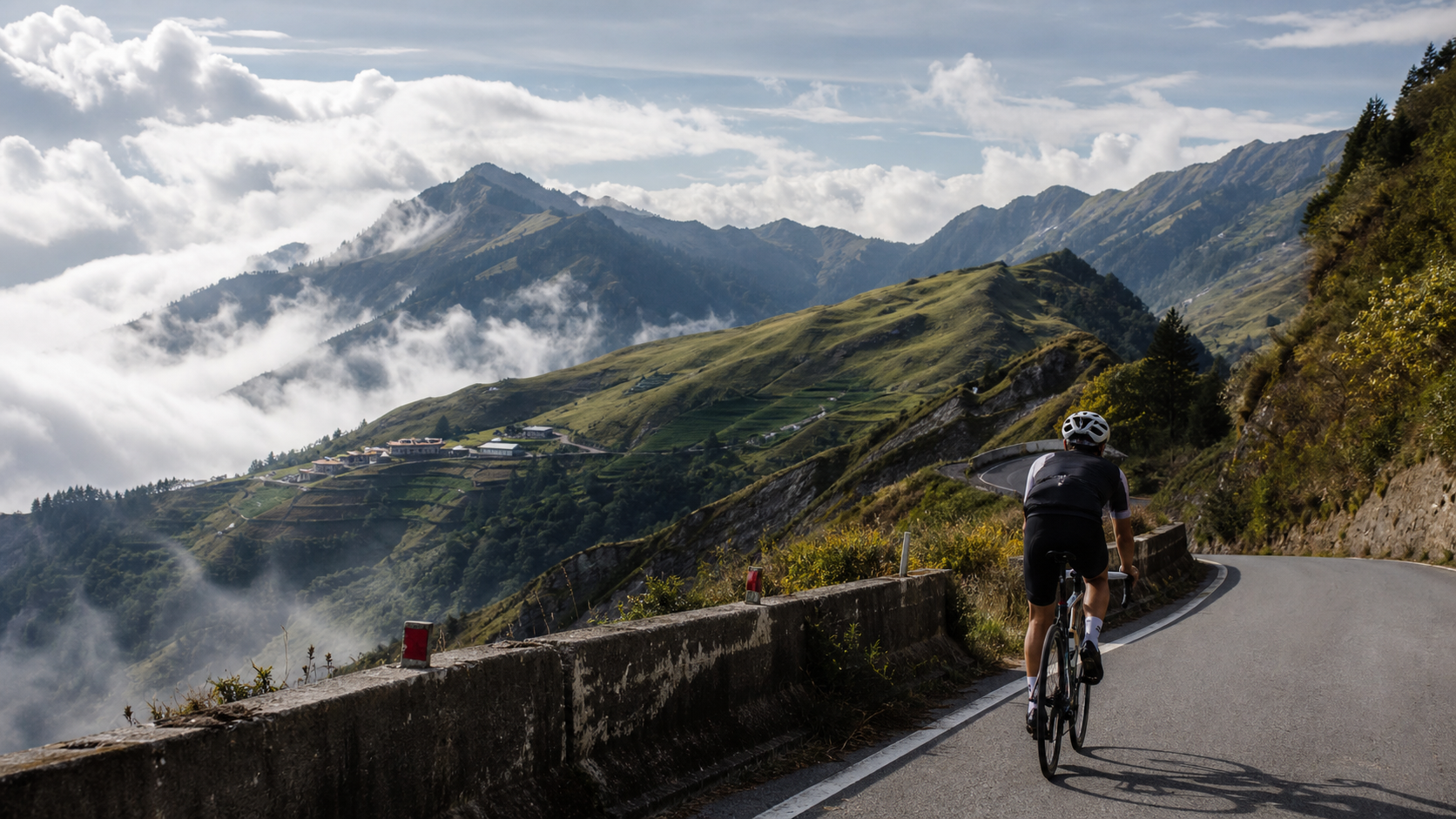
The sea of clouds is one of the most commonly mentioned sights on this type of high-altitude route. Under suitable weather and timing conditions (actual views depend on the day’s climate and cannot be guaranteed on every ride), when riders climb to a certain height and look back at the path they’ve come, there’s a chance to see clouds surging and spreading through the valleys, forming a magnificent white ocean—and you stand above the sea of clouds, each pedal stroke bringing you a step closer to the sky. The unpredictability of this sight is, in some ways, part of what makes high-mountain riding so alluring—it rewards not just physical effort, but also a measure of luck and patient waiting for the right conditions.
As for the ecological aspect, Taroko National Park and its surrounding high-mountain zones are among Taiwan’s richest areas for endemic biodiversity. During the ride, with luck, you might spot Formosan macaques moving through the forest from a distance—they are relatively common primates in Taiwan’s mid-to-high elevation forests. At even higher elevations, in the arrow bamboo grasslands or coniferous forest environments, Taiwan’s endemic high-mountain birds—including various pheasant and laughingthrush species—also inhabit these areas. Whether you actually spot them is purely a matter of chance, but those moments when, between heavy breaths and pedal strokes, you suddenly catch a glimpse of mountain life, often become unexpectedly vivid fragments of the riding memory.
To be honest, the presentation of these scenic and ecological views depends heavily on the weather, season, and luck of the moment. No one can guarantee that every attempt at this route will encounter rolling seas of clouds or wildlife sightings. But it is precisely this uncertainty that makes every ride a unique experience—you never know what response the mountain will give you around the next bend.
Riding Narrative: A Dialogue Between One Person and a Mountain
The morning air still carried a chill as I locked my water bottle securely, double-checked the gear ratio and brakes, took a deep breath, and pushed down on the pedals for the first revolution toward the Lixing end. For the first four kilometers, my body felt relatively relaxed, and a fleeting thought even crossed my mind—“this road doesn’t seem as daunting as I imagined”—an illusion that would later prove to be nothing more than the mountain’s polite courtesy toward a first-time visitor.
Around one-third of the way in, the gradient began to reveal its true character. My once-steady breathing gradually grew more rapid, not because the slope suddenly steepened, but due to something subtler, harder to articulate—a signal that altitude was beginning to speak to my body. Each breath seemed to require more effort than usual to draw in the same amount of oxygen. This sensation is difficult to describe precisely in words; suffice it to say, the body realizes before the mind that it is entering a different altitude.
At a hairpin turn midway through, I stopped to take a sip of water and looked back toward the direction I had come from. The sight before me instantly made me forget the soreness in my legs—layer upon layer of ridgelines in the valley, rendered in varying shades of blue-green under the pre-noon light, with thin mist slowly gathering in the distance, as if the mountain were brewing something. In that moment, I suddenly understood why people would willingly return to such a route to challenge themselves again and again—not to compete with anyone, but for these moments of dialogue with heaven and earth that can only be truly felt by being there in person.
The final three kilometers were the most honest part of the entire ride. With energy nearly depleted and the gradient showing no sign of relenting, every revolution of the pedals required a more deliberate intervention of willpower to maintain a steady cadence. At this point, various thoughts would involuntarily surface—“how much longer,” “should I get off and walk a stretch,” “why did I ever choose to challenge this route.” Yet it is precisely in this state of physical and mental exhaustion that a purer form of focus emerges: the world shrinks down to just the small patch of asphalt ahead, the sound of your own breathing, and the solid sensation of each pedal stroke.
When I reached the summit, there was no grand celebration—only an indescribable sense of calm and fulfillment. Looking back at the road I had traveled, then at the numbers on the display—14.29 kilometers, over 940 meters of climbing—I suddenly felt that these figures represented far more than their literal meaning. They were a personal record of perseverance, of dialogue with oneself, and of choosing to keep moving forward even at the edge of one’s limits.
What This Route Means to Riders: A Ceremony of Fulfilling a Dream
In Taiwan’s road cycling community, Hehuan Mountain and its surrounding high-altitude routes have long been regarded by many riders as a “dream-fulfilling” level of challenge. This claim may sound somewhat exaggerated, but if you have spent months training hard at low altitude and finally stand at the starting point of such a route on a certain morning, you will understand the weight behind that word.
For many amateur riders, regular training is mostly confined to general roads or suburban hills near home, limiting the gradients and distances they can challenge. The Hehuan Mountain route system, especially sections like the final 14K of the Lixing end that combine distance, elevation gain, and the unique factor of high altitude, represents to some degree a “graduation exam”—it tests not just leg strength, but also the respiratory system’s ability to adapt to low-oxygen environments, the stability of mental fortitude under extreme conditions, and the thoroughness of advance preparation.
Many riders treat completing such a route as a significant milestone in their road cycling career, even going so far as to set aside dedicated time, invite fellow riders to join, and treat it as a collective challenge imbued with ceremonial significance. Behind this phenomenon lies a simple yet profound value in Taiwan’s cycling culture: rather than chasing speed and rankings, what more riders care about is “whether I have truly and honestly faced a mountain.”
The Lixing end, a section relatively less frequently mentioned, offers an alternative in its own way—for riders who have already conquered the classic Wuling route and yearn to challenge a different perspective and path, this is a route that brings a sense of novelty while carrying equally substantial weight. It doesn’t need to compete with popular routes for fame, because its own data—14.29 kilometers, 940.2 meters of elevation gain, 6.6% average gradient, Strava Category 5 classification—is already sufficient proof of its value.
Seasonal Scenery: Autumn Foliage, Seas of Clouds, and Possible Snow
Seasonal changes in high-altitude mountain areas are often more pronounced and dramatic than on the plains, which gives the routes around Hehuan Mountain distinctly different appearances across the seasons. It must be stated upfront that the seasonal landscapes described below are highly dependent on the weather conditions of any given year; whether they can actually be witnessed should be based on current on-site conditions and official information, and should not be treated as a guaranteed occurrence.
Autumn Foliage is one of the well-known seasonal spectacles in many of Taiwan’s high-altitude regions during specific times of the year. As temperatures gradually cool, the leaves of certain deciduous tree species turn red and yellow, adding a splash of brilliant color to the predominantly green mountain forests. If you challenge this route at the right time of year on a clear day, you may have the opportunity to capture such season-limited scenery along the way, though the exact timing and intensity of the color change vary from year to year depending on climatic conditions.
Seas of Clouds, as mentioned earlier, are a relatively common yet still elusive sight on such high-altitude routes. Under specific atmospheric pressure and humidity conditions, clouds tend to accumulate and surge dramatically in the valleys. For riders departing in the early morning or before noon, the chances of encountering this spectacle are relatively higher, but it still depends on the actual weather of the day.
Winter Snow is a special landscape that may appear in this high-altitude region when conditions are right. Taiwan’s high mountain areas do have recorded snowfall in winter, but the timing, extent, and depth of snow vary enormously from year to year. Moreover, roads in snowy or icy conditions pose considerable safety risks for general road cycling, so it is essential to defer to officially announced road status and not to challenge this route during periods of ice or snow.
Regardless of which season-limited scenery it is, the message they collectively convey is consistent: this high-mountain environment always maintains its own rhythm and temperament, refusing to change to accommodate travelers’ expectations. And this unpredictability is, to some extent, one of the core fascinations of high-altitude cycling—you can never fully control it, but precisely because of that, every encounter feels all the more precious.
Suggested Side Trips and Pre-Ride Reminders
If you plan to challenge the final 14K Lixing end route of Hehuan Mountain, beyond physical and equipment preparation, consider planning the entire trip as an in-depth journey that combines the cycling challenge with exploration of local culture and humanity.
Pre-Ride Information Check: Since this route passes through mountainous terrain, it is strongly recommended to check the latest road condition announcements from Taroko National Park Headquarters or relevant authorities before departure, confirming whether the road is open and whether there are any traffic controls or construction information along the way. Mountain road conditions change rapidly—do not rely on outdated information.
Respect and Exploration of Local Indigenous Culture: If your schedule permits, consider slowing down and making brief stops at the indigenous communities along the way, learning about the Atayal people’s way of life and cultural context with respect and friendliness. This not only enriches the meaning of the entire journey but is also a basic courtesy owed to local residents—riders are merely passersby on this land, while the community members have lived here for generations.
Riding Companions and Safety Backup: Given the route’s altitude and the potential risk of altitude sickness, it is strongly advised not to challenge this route alone, especially for first-time riders. Having companions not only provides mutual physical and psychological support but also offers the most immediate assistance and judgment in case of emergencies.
Photography and Documentation Suggestions: The landscape along this route changes richly. If time and energy permit, consider making brief stops at safe shoulders or viewpoints along the way to document the changing scenery with a camera or phone—from tribal farmland to high-mountain forest, this gradual visual transition is a unique asset of this route, worthy of visual documentation rather than merely riding past in haste.
Rest and Recovery After Descending: After completing such a high-intensity, high-altitude challenge, the body typically finds itself in a state of considerable fatigue. It is recommended to arrange adequate rest time and proper nutritional replenishment after the return trip or descent, allowing the body to gradually recover from the physiological strain of high altitude. Avoid immediately embarking on a long drive home in a state of extreme exhaustion.
Light and Shadow in the Mountains: A Day-Long Weather Theater
Anyone who has ridden high-altitude routes more than a few times shares a common realization—in places like this, the weather is never a fixed backdrop, but rather a theater that changes at any moment, with you standing at center stage.
Setting off in the early morning, the sky may still carry a nearly translucent clarity, with sunlight slanting through the treetops, casting dappled light patterns on the asphalt. The air during this window is usually the most stable, and visibility is at its best—one of the reasons many seasoned riders prefer an early start—not just to avoid potential weather shifts later on, but because that atmosphere of a quiet mountain forest, with only the sound of your own breathing and the turning of your pedals, is itself a rare pleasure.
As time progresses, especially into the later morning hours or the afternoon, convective cloud systems in the mountains begin to stir. The originally clear blue sky can, within just an hour or two, be replaced by gradually gathering cloud layers. The speed of this change often exceeds expectations for those accustomed to flatland weather—you may have just felt grateful for the sunny conditions, when in the blink of an eye the mountain peaks are shrouded in a thin mist, visibility drops sharply, and temperatures fall noticeably.
This dramatic shift in weather is, to some extent, the part of high-mountain riding that inspires both awe and reverence. It reminds every rider that they are, after all, an exceedingly small passerby in this vast mountain wilderness—the mountain will not adjust its pace to accommodate your itinerary. It is precisely for this reason that those riders who, during moments of clear skies and open vistas, are able to witness with their own eyes the surging sea of clouds and the unbroken chain of peaks, tend to cherish that fortune all the more—because they know full well that on their next visit, they may not encounter the same scenery again.
Experienced riders typically learn to coexist peacefully with this uncertainty rather than fight against it. Doing your homework before departure, keeping a constant eye on changing sky conditions, and decisively turning back when necessary—these seemingly conservative decisions are, in fact, the most fundamental respect one can show this mountain wilderness. After all, the mountain will always be there, but opportunity will not forever wait for those who come unprepared.
Riding with Companions: Sharing Makes It More Meaningful Than Going Alone
Although this route can be tackled solo, if given the chance, I would recommend riding it with familiar companions. High-altitude riding inherently carries a degree of risk, and the presence of riding partners is not only a safety net but also an indispensable part of the journey’s emotional dimension.
I still remember arranging with several teammates to challenge a similar high-altitude route together. Before departure, everyone checked each other’s gear at the starting point, confirming that water bottles and supplies were complete—that atmosphere, tinged with both nervousness and anticipation, was itself a rare collective memory. During the ride, although everyone’s pace and fitness levels differed, and distances inevitably opened up on the gradients, occasionally glancing back at a switchback to confirm everyone was still in sight, or passing a sip of water and a word of encouragement—“Keep going, almost there”—at a roadside shoulder during a brief rest, these small interactions often linger in memory far longer than the sense of accomplishment at reaching the finish line.
After arriving at the summit, everyone took off their helmets, drenched in sweat yet unable to hide their smiles as they high-fived and took photos, sharing their experiences and amusing anecdotes from the ride—who nearly cramped up on which section, who was so stunned by the sea of clouds that they forgot to pedal, who pushed through the final three kilometers on sheer willpower alone. These stories would, in the days to come, become recurring topics at team gatherings, and they would give this otherwise quiet, seldom-discussed route its own warmth and meaning among friends.
This is also why, even though this route is not as well-known as the classic Wuling sections, it still deserves to be recorded, shared, and discovered by more riders—because every road that has been earnestly pedaled deserves to have its own story.
Conclusion: A High-Altitude Memory Worth Revisiting Again and Again
The final 14K of the Lixing side of Hehuan Mountain, after all, is not merely a set of numbers on a Strava record—14.29 kilometers, 940.2 meters of climbing, 6.6% average gradient, Category 5 classification. It is a complete journey that condenses geographical change, cultural history, ecological diversity, and a test of personal willpower.
For riders who have personally pedaled this route, what those numbers carry behind them is the apprehension of setting out in the early morning, the self-doubt when breathing grows ragged mid-climb, the awe when the sea of clouds suddenly appears in the valley, and that indescribable yet utterly real sense of accomplishment at the moment of reaching the summit. These feelings are something no data table can fully convey.
If you too are ready to take on this route, please remember—the mountain will always be there; it will not shorten its distance or lower its gradient just because your preparation today is less than thorough. True fulfillment has never been about hastily conquering a mountain, but about approaching it with sufficient respect, thorough preparation, and a heart willing to honestly face your own limits—pedaling, one stroke at a time, one revolution at a time, to etch this road into your memory. May every rider who takes on this route complete their own high-altitude chapter with safety and a full heart.
Related Reading
- From Sea Level to the Clouds: The Human Spirit and Imagined Riding Journey of the Eastbound Wuling–Shenmu Cup
- Complete Guide to the Final 14K of the Lixing Side of Hehuan Mountain: Data Analysis of 14.29 Kilometers and 940 Meters of Climbing at High Altitude
- Eastbound Wuling–Shenmu Cup Race Strategy: Decoding the 19.8-Kilometer Data and a Full Guide to Long-Ride Gear and Nutrition
- Riding Along the Nanshi River to a Cloudtop Tribe: The 14.4-Kilometer Riverbound Road to Fushan
一定要騎一次!阿里山最深處:里佳部落!單車旅行 | 2800m爬升 | 深度部落體驗:嗨翻晚會、螢火蟲、銀河 | feat. JJSC & 廢物伙伴 | 公路車 CT Yeh
9 個月前
里佳部落 阿里山單車深度旅遊! | 竹山/草嶺/來吉/奮起湖 | 無敵銀河絕景 全新路線探索! 驚險狀況百出! | 4K沉浸式畫質 | 公路車 | CT Yeh
3 年前
藤枝二集團 單車行 Day1 | 南部小武嶺 | 爬坡爬到罵罵叫 | JJSC | 公路車 | CT Yeh
3 年前
嘉義大埔、阿婆灣挑戰賽,美到以為在日本!ft. 環騎5 Cool 西拉雅188 / 公路車 / CT Yeh
7 個月前
阿里山塔塔加 兩倍特濃版!全新隧道開通! 進喔!公路車 | CT Yeh
3 年前
台北闊瀨陡坡 騎旅 / 日本單車雜誌編輯車友臨時加入!/ 髮香才是最強的 / feat. 北迴歸線小隊 / 公路車 CT Yeh
6 個月前
那瑪夏x茶山 阿里山系深山單車行 Day2 累積爬升6000M | 🥶超陡連續下坡 整路看隊友刷 | 爬升一座西進武嶺 | JJSC | 公路車 | CT Yeh
3 年前
大武山20%魔王陡坡【JJSC南台灣遊騎Day2】!屁股真的要裂開了...凡士林抹滿也沒用?神秘金教堂還有超便宜夜市
3 個月前