Lingyun Zen Temple and Yinghan Ridge: A Climbing Route Where a Century of Faith Meets the Tamsui River Estuary
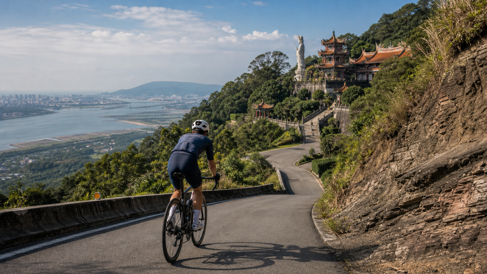
Some climbing routes end at a mere elevation marker; others end at an ancient temple that has carried over a century of faith and memory. The upper section of Lingyun Road belongs to the latter. As you push the pedals, battling a 409.7-meter ascent with an average gradient of 6.2%, you are in fact riding toward a monastery that witnessed a turning point in Taiwan’s religious history—Lingyun Zen Temple.
The Westernmost Edge of a Volcano: The Story of a Mountain
Before telling the story of Lingyun Zen Temple, it is necessary to first clarify the story of Guanyin Mountain itself. Many people are accustomed to treating Guanyin Mountain as an independent mountain range, but a more precise geological description is that Guanyin Mountain belongs to the westernmost part of the Datun Volcano Group, sharing the same composite volcano system as Datun Mountain and Qixing Mountain. It is only because it stands near the mouth of the Tamsui River, with a relatively prominent geographical position and a visual sense of distance from other peaks, that people develop the illusion that it is an independent range.
This composite volcanic geological structure, formed by alternating layers of volcanic debris, tuff, and lava, has also created Guanyin Mountain’s distinctive rugged terrain—from a distance, the ridgeline undulates gracefully, and it is said that from certain angles, the mountain’s silhouette resembles a reclining Buddha or the profile of Guanyin, the Goddess of Mercy. This is also the most widely circulated origin of the name “Guanyin Mountain.” When you ride the upper section of Lingyun Road, as altitude gradually increases, the occasional exposed rock layers and soil strata on both sides are, in fact, the silent records left by this volcanic geological history.
The first time I realized I was riding on the body of an active volcano, a peculiar sense of awe welled up inside me. When we usually talk about “climbing,” we mostly focus on gradient numbers and physical exertion, rarely stopping to think that the ground beneath our feet carries a geological timescale far longer than human history. Every pedal stroke on the upper section of Lingyun Road is, to some extent, a measurement of the terrain height that this volcano has stacked up over millions of years.
Lingyun Zen Temple: A Century-Long Path from a Small Hermitage to a Sectarian Stronghold
The upper section of Lingyun Road leads to Lingyun Zen Temple. The history of this monastery can be traced back to Meiji 42 (1909 AD), when Liu Jinbo, a merchant from Dadaocheng, donated funds to assist Master Baohai in establishing it. In an era when Taiwan was still in the early stages of Japanese rule and religious development was still finding its form, the establishment of Lingyun Zen Temple reflected, to some extent, a model of folk belief combining with merchant capital to jointly support local religious spaces.
The monastery’s development was not achieved overnight. After its initial construction, Lingyun Zen Temple underwent two expansions in 1914 and 1918, gradually becoming more complete, and later joined the Myōshin-ji school of the Rinzai sect, becoming a representative stronghold within Taiwan’s Buddhist sectarian system at the time. In 1926, the monastery established the “Taipei Saigoku Sanjūsankasho Reijō,” now known as the Pilgrimage Trail, allowing devotees and visitors to make a pilgrimage along a specific route. This religious spatial planning that incorporated pilgrimage path design was a remarkably forward-thinking experiment among Taiwanese monasteries of that era.
The monastery’s architecture itself continued to expand and improve over time. Between 1979 and 1983, Lingyun Zen Temple built the Great Dharani Hall, which became an important religious architectural landmark within the monastery. However, the power of nature has never truly been far from this monastery built on volcanic geology—in 1992 and 1993, Lingyun Zen Temple suffered landslides twice, damaging the rear hall. Such events remind us, to some extent, that even religious sites carrying a century of faith cannot be completely exempt from the risks posed by the geological environment on which they stand—the loose soil layers of composite volcanic terrain do carry the potential for collapse under certain conditions.
Today, Lingyun Zen Temple, located at No. 116, Section 3, Lingyun Road, remains an important religious site for devotees in the Wugu and Luzhou areas, and is a landmark that many hikers and cyclists inevitably pass or pause at when challenging the Guanyin Mountain route. When you ride to the monastery’s vicinity, the atmosphere of solemnity that has endured a century of wind and frost forms a curious contrast with the sweat you just shed during the climb—physical fatigue meets the quiet weight of accumulated time, as if reminding the rider that the years this building has witnessed are far longer than a single climbing challenge.
Yinghan Ridge: The Iron-Blooded Memory Behind a Name
If Lingyun Zen Temple represents the depth of religion and faith, then the Yinghan Ridge Trail represents a completely different character of this mountain—unyielding, resilient, tinged with a militaristic willpower. The trailhead of Yinghan Ridge Trail is located near Lingyun Zen Temple, stretching 1,563 meters in total, making it one of the most well-known hiking routes in the Guanyin Mountain area.
The origin of the name “Yinghan Ridge” comes from the historical background of the Military Police School establishing physical training facilities here in 1961. One can imagine that the military police trainees of that era were precisely on this steep mountain path, training their physical strength and willpower again and again. The term “Yinghan” (Iron Man) is, to some extent, a direct naming and tribute to that iron-blooded training spirit. To this day, although the military training purpose has faded, this powerful name has been preserved, becoming a spiritual totem that countless hikers and sports enthusiasts silently invoke when testing their physical limits.
As cyclists, although the upper section of Lingyun Road we ride and the Yinghan Ridge Trail are different route systems (the trail is a hiking route, while the upper section of Lingyun Road is an industrial road open to bicycles), the geographical contexts of the two are closely connected, and to some extent they share the same “tough” spiritual temperament. The upper section of Lingyun Road, with its 6.2% average gradient and 409.7-meter ascent, is nothing less than a cyclist’s own “Yinghan Ridge”—it tests every challenger’s willpower and muscular limits with concentrated, unforgiving gradients.
Fengguidou Lake and Niugangleng: Place-Name Memories Hidden in Mountain Trails
The Guanyin Mountain area has several other well-known hiking trails worth mentioning as a supplement to understanding the layered landscape of this mountain region. The Niugangleng Trail stretches 753 meters, while the trail whose correct place name should be “Fengguidou Lake” extends 788 meters, making it one of the relatively short but steep sections in the area. Although these place names are mostly not directly on the cycling route, they collectively form the rich network of hiking trails in the Guanyin Mountain area, making this mountain not just a single climbing landmark, but a composite mountain region interwoven with multiple trails and layers of historical memory.
The place name “Fengguidou Lake” itself carries a simple charm unique to Taiwanese local place names—not a deliberately crafted poetic naming, but a designation passed down orally by local residents over a long period and gradually established by convention. Such place names often carry clues about early reclamation or topographical descriptions. Although the precise etymological research of the name is beyond the scope of this article, simply pronouncing the name evokes a sense of intimacy deeply connected to the land.
Facing the Tamsui River Mouth: A Riding Experience of Views and Imagination
As a climbing route, one of the most anticipated aspects of the upper section of Lingyun Road is the gradually unfolding view as altitude rises. Guanyin Mountain’s terrain faces the direction of the Tamsui River estuary, and on clear days, the view can indeed be quite expansive. Many riders choose to challenge this route in the early evening, not only to avoid the daytime heat but also hoping to reward their legs with the open river-mouth scenery after completing the arduous climb.
I will always remember that moment one evening when, after completing the climb, I stood at a scenic overlook to rest—in the distance, the Tamsui River meandered toward the sea, and the sky began shifting from azure to warm orange tones. The entire process was so quiet that only my own heavy breathing and the occasional mountain breeze remained. The emotion evoked by that scene came largely from the physical price paid during the preceding climb—had I arrived easily by car, the weight of this scenery would likely have been greatly diminished. Of course, such views are not guaranteed on every visit; weather, cloud cover, and air quality all influence the visibility at any given moment. But precisely because of this uncertainty, every time one truly encounters clear, bright weather, it feels especially worth cherishing.
A Rider’s Record of Climbing State of Mind
The climbing process on the upper section of Lingyun Road, to be honest, is not easy or pleasant. The 6.2% average gradient with almost no respite sections makes the entire ride closer to a tug-of-war with one’s own willpower than a leisurely sightseeing ride. But it is precisely this uncompromising intensity that makes the sense of accomplishment after completing it especially powerful.
I remember the first time I challenged this route, midway through I briefly doubted whether I had overestimated my fitness. The burning sensation in my legs and rapid breathing made me want to stop and walk my bike. But when I thought of the resilient spirit represented by the name Yinghan Ridge, it gave me a certain psychological support to keep pedaling—if this mountain area had once trained countless people willing to endure arduous training, then a mere climb seemed no reason to give up easily.
When I reached the end and saw the solemn architectural complex of Lingyun Zen Temple come into view, the complex emotion mixing fatigue and relief was something I rarely felt on other routes. It was not just a physical completion, but more like a spiritual settling—as if through this climb, I had briefly forged a real connection with the century-long history carried by this mountain and this monastery.
Guanyin Mountain Through the Seasons: Changes of Light and Climate
The seasonal expressions of Guanyin Mountain are completely different from the Yangmingshan Zhuzihu valley mentioned earlier. Zhuzihu is an inland basin surrounded by mountains, while Guanyin Mountain is an independent peak standing at the edge of a river mouth, directly conversing with sea breezes and river winds. This geographical position gives its seasonal scenery a stronger sense of openness and variability.
In spring, the vegetation of Guanyin Mountain gradually turns lush and green, with the humid air occasionally carrying the distinctive scent of mountain flora. Riding the upper section of Lingyun Road in this season, temperatures are usually still pleasant, not as prone to drenching sweat on steep sections as in summer, making it a relatively friendly time to challenge. However, spring is also the season with higher chances of weather fronts and rainfall, and mountain roads can occasionally be slippery, requiring extra attention to road conditions while riding.
Challenging the upper section of Lingyun Road in summer is a dual test of willpower—not only are the gradients steep, but the sun exposure and humid heat push the difficulty of the entire ascent to another level. Many experienced riders choose to go in the early morning or near dusk to avoid the hottest midday hours. The additional benefit of the evening hours, as mentioned earlier, is the chance to enjoy the changing sky toward the Tamsui River mouth after completing the climb, using visual pleasure to somewhat balance the physical expenditure.
In autumn, Guanyin Mountain typically enjoys more stable and drier weather, making it the season most suitable for extended outdoor activities throughout the year. Air quality at this time is also often better. If lucky enough to encounter clear, cloudless weather, standing at a scenic overlook to gaze at the Tamsui River estuary offers better visibility than other seasons, making it a particularly favored time for photography enthusiasts and riders who enjoy distant views.
In winter, due to the influence of the northeast monsoon, Guanyin Mountain, as an independent peak facing the sea, experiences winds that are noticeably stronger and more direct than inland mountain areas. The combination of low temperatures and strong winds can dramatically lower the perceived temperature. Riders challenging the upper section of Lingyun Road must take adequate measures to stay warm, especially during the descent phase after completing the climb—sweat-soaked clothing combined with strong mountain winds means the risk of hypothermia should not be underestimated. But winter Guanyin Mountain also has its unique desolate beauty—scenes woven from bare branches and mist carry a rugged, austere quality that contrasts sharply with the lush vitality of spring and summer.
A Brief Encounter with Land and Faith
While riding the upper section of Lingyun Road, one occasionally encounters devotees heading to Lingyun Zen Temple to worship, or hikers preparing to challenge the Yinghan Ridge Trail. These fleeting encounters always make me feel that this mountain gathers people with different faiths and different athletic purposes—some come to train their fitness, some come seeking spiritual tranquility, and others simply want to admire the unique geological landscape and expansive views here.
This interweaving of diverse people, to some extent, reflects the complex and rich identity of Guanyin Mountain itself—it is both a composite volcanic terrain worthy of geological study, an important stronghold of religious faith, and a popular venue for physical training and outdoor sports. As cyclists, every section of road we pedal intersects with these different identities. Even though our purposes differ, we share the same challenges and scenery bestowed by this mountain.
Once during a ride, I encountered an elderly man who looked quite advanced in years yet walked with steady steps, slowly heading toward the trailhead of Yinghan Ridge Trail. After a simple nod of greeting, he smiled and said something like, “This mountain—young people ride bikes, old people walk. Everyone has their own way of training.” Though brief, those words left a deep impression on me—they precisely captured why Guanyin Mountain can simultaneously attract cyclists and hikers: the challenges this mountain offers are multi-layered, and everyone can find their own way to engage in dialogue with this volcanic terrain.
What This Route Means to a Rider
If Zhuzihu Road taught me that “gentle, layered scenery is equally worth revisiting,” then the upper section of Lingyun Road taught me a completely different lesson—the psychological quality of facing difficulties head-on without avoiding challenges. The climbing process with a 6.2% average gradient and almost no breathing room is, to some extent, the extension of the spirit represented by the name Yinghan Ridge into the sport of cycling.
Every time I challenge this route, I think of those military police trainees who underwent physical training here in 1961. Although the historical context and training purposes are completely different from today’s recreational cycling, the spiritual core of self-discipline through arduous terrain seems to transcend time, still lingering in these mountain paths, continuing to influence every later visitor who chooses to come and challenge themselves here.
After completing the climb and arriving at the vicinity of Lingyun Zen Temple, looking at this ancient monastery that has endured a century of wind and frost and even survived two landslide damages while still standing tall, I always feel a particularly grounded sensation—as if through the effort of my own legs, I have briefly earned the qualification to converse with this long history. This feeling cannot be replicated by arriving easily by car, and it is what I consider the most precious aspect of the upper section of Lingyun Road: it uses its demanding gradients to filter who is willing to put in the effort, and rewards every rider who perseveres to the end with the humanistic depth at the finish.
Suggested Side Trip: Adding the Upper Section of Lingyun Road to Your Guanyin Mountain Cultural Journey
If time and energy permit, after completing the climbing challenge of the upper section of Lingyun Road, it is recommended to pause briefly around Lingyun Zen Temple to experience the solemn atmosphere of this century-old monastery and admire the religious and cultural landscape preserved along the Pilgrimage Trail. Riders with ample energy and hiking gear prepared may also consider parking their bikes temporarily and walking a section of the Yinghan Ridge Trail, personally experiencing this famous hiking route named after “Iron Men” and feeling the mountain scenery from a perspective different from cycling.
Although the terrain of the Guanyin Mountain area is not particularly vast, it condenses multiple layers of geological wonders, religious faith, military training history, and hiking trail culture, making it a mountain worth revisiting repeatedly, with new discoveries each time. Whether you are drawn by the 6.2% average gradient to challenge your physical limits, or simply seeking a quiet corner overlooking the Tamsui River mouth, the upper section of Lingyun Road and the Lingyun Zen Temple it leads to will respond to every visit in the unique way of this westernmost peak of the volcano group.
Rediscovering a Mountain from a Rider’s Perspective
After riding different routes for a long time, one gradually develops a personal way of “getting to know a mountain”—not through contour lines on a map, nor merely through scattered information found online, but through the bodily memory accumulated from every gradient actually pedaled and every moment of gasping breath. For me, Guanyin Mountain is precisely such a mountain that, through repeated challenges on the upper section of Lingyun Road, has gradually transformed from “a green patch on the map” into a concrete existence “with warmth, with stories, with bodily memory.”
The first time I rode this route, my understanding of Guanyin Mountain was probably limited to a vague impression of “a famous scenic mountain in New Taipei City.” But with each successive challenge, I began to notice subtle differences in road surface materials across different sections, the seasonal changes in vegetation at turns, and the play of light and shadow on rock faces at different times of day. The accumulation of these details has turned this route from a string of cold data (4.73 kilometers, 409.7-meter ascent, 6.2% average gradient) into a riding memory with flesh and blood, worth savoring repeatedly.
I have also gradually come to understand why many experienced riders are particularly fond of these “short-distance, high-intensity” routes, repeatedly challenging them and repeatedly improving their completion times. This process of repeatedly visiting the same route is, to some extent, like building a long-term relationship with the mountain—each ride layers new feelings and discoveries on top of existing understanding. Over time, this route ceases to be merely a tool for physical training and becomes something like an “old friend.” Even though the route itself never changes, each meeting still brings different states of mind and insights.
Words from the Heart for Those Challenging the Upper Section of Lingyun Road for the First Time
If this is your first time preparing to challenge the upper section of Lingyun Road, I would like to offer a few suggestions that are less “data-driven” and closer to mental preparation. First, please do not hold excessively high expectations for your completion time. The intensity of this route is indeed not to be underestimated. Even riders with a solid climbing foundation may find themselves caught off guard by the continuous steep sections in the middle. Allow yourself to slow down when necessary, or even stop briefly to catch your breath—these are not failures, but honest expressions of respect for your own body.
Second, try to find things other than gradient numbers to divert your attention during the climb—perhaps the changes in roadside vegetation, the occasional bird calls, or simply focusing on your own breathing rhythm. The intensity of this route can easily trap one in an anxious state of staring only at the bike computer and thinking only of finishing quickly. But if you can适时 shift your attention to broader sensory experiences, you may instead find the opportunity to endure the most difficult sections with a calmer mindset.
Finally, when you finally arrive at the vicinity of Lingyun Zen Temple and see that architectural complex that has weathered a century, please give yourself some time to fully feel the grounded sense of having completed the challenge. This is not just a physical achievement, but also a precious experience of connecting with this mountain and its history. Whether or not you ever challenge this route again, this first memory will become a chapter in your cycling life worth savoring repeatedly.
Related Reading
- Guanyin Mountain Lingyun Road Practical Guide: 4.73 km, 409.7 m Ascent, How to Ride the 6.2% Average Gradient Volcanic Climb
- Riding Where the Clouds Rise: Sea of Clouds, Sacred Springs, and Wushe Memories from Lushan Hot Spring to Provincial Highway 14
- A Stick of Incense at the End of the Mountain Trail: Cycling Notes on Sanxia Li Mountain Shrine
- Taoyuan Guanyin to Xinwu Coastal Route: A Long Flat Ride on Northern Taiwan’s West Coast
台北闊瀨陡坡 騎旅 / 日本單車雜誌編輯車友臨時加入!/ 髮香才是最強的 / feat. 北迴歸線小隊 / 公路車 CT Yeh
6 個月前
觀霧 變好騎了! | 北高車友爆笑大會師 | 公路車 | 單車旅遊 Taiwan Cycling Route GuanWu
6 年前
萬年峽谷! 30% 超激陡坡 里佳部落DAY2 還是很硬! | 公路車 | CT Yeh
3 年前
大武山後門26%歡樂陡坡!JJSC南台灣單車行Day2 / 被颱風追著跑 / 公路車 / CT Yeh
2 年前
#北橫 + #北進武嶺 最硬的員工旅遊 EP1 | #公路車 #拉拉山 | 明池 | 武嶺 | 武陵農場 | 雲海 | Taiwan Cycling Route Wulin
6 年前
大武山20%魔王陡坡【JJSC南台灣遊騎Day2】!屁股真的要裂開了...凡士林抹滿也沒用?神秘金教堂還有超便宜夜市
3 個月前
新竹羅平 x 天湖部落 大禹嶺級變態陡坡! 4K超高畫質 空拍 | 公路車
5 年前
一定要騎一次!阿里山最深處:里佳部落!單車旅行 | 2800m爬升 | 深度部落體驗:嗨翻晚會、螢火蟲、銀河 | feat. JJSC & 廢物伙伴 | 公路車 CT Yeh
10 個月前