Suhua Alternate Routes: A Choice That Delivers Both Safety and Scenery
The Suhua Highway (the Su'ao to Hualien section of Provincial Highway 9) is one of Taiwan's most beautiful yet most dangerous roads. Narrow lanes, frequent gravel trucks, and the ever-present risk of falling rocks deter many cyclists. Although the Suhua Improvement Project (Suhua Gai) has opened some sections, bicycles are still prohibited from entering the Suhua Gai tunnels. As a result, for riders wanting to cycle from Yilan to Hualien, choosing an inland alternate route has become a safer option that is equally spectacular.
Route Overview
Start: Yilan City (approx. 10m elevation)
End: Hualien City (approx. 20m elevation)
Total Distance: approx. 180-200 km (depending on the alternate route chosen)
Total Elevation Gain: approx. 2,500-3,500 m
Difficulty: ★★★★☆ (High)
Recommended Days: 2-3 days
Alternate Route Option 1: Via Taipingshan and Cilan
Yilan to Tuchang (approx. 55 km, approx. 1,800 m elevation gain)
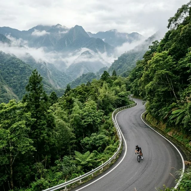
Starting from Yilan City, take Provincial Highway 7C through Sanxing and Niudou, then connect to Provincial Highway 7 toward Taipingshan. The first half of this stretch passes through the pastoral scenery of the Yilan Plain, and after Sanxing you begin entering the Lanyang River valley. The real climbing starts at Niudou, with gradients gradually increasing from 3% to 5-6%. Along the way you'll pass the Cilan National Forest Recreation Area, home to a spectacular grove of thousand-year-old sacred trees. Continue climbing to Tuchang at roughly 1,800m elevation, once the starting point of the Taipingshan Forest Railway.
Tuchang to Taipingshan (approx. 20 km, approx. 200 m elevation gain)
From Tuchang you can detour into the Taipingshan National Forest Recreation Area. Taipingshan's Cuifeng Lake is Taiwan's largest alpine lake at roughly 1,840m elevation, well worth a visit if time allows. However, the round trip adds about 40 km to your total mileage. If your goal is reaching Hualien, you may prefer to stay overnight near Tuchang and descend the following day.
Notes on This Alternate Route
There is currently no direct road connecting the Taipingshan area to Hualien. In practice, most riders continue along Provincial Highway 7 from Cilan to Baitao Bridge, then take Provincial Highway 7A over Siyuan Pass (elevation 1,948m), enter Taichung's Heping District, connect to Provincial Highway 8 (the Central Cross-Island Highway), and ride through Taroko to reach Hualien. This larger loop extends the total distance to over 250 km and is best suited to a 3-4 day itinerary.
Alternate Route Option 2: Via Provincial Highway 7A and Siyuan Pass
Yilan to Siyuan Pass (approx. 90 km, approx. 2,000 m elevation gain)
From Yilan, take Provincial Highway 7 toward Datong Township, continuing past Cilan and along the upper reaches of the Lanyang River. The scenery on this route is extraordinarily beautiful, passing through pristine mixed broadleaf and coniferous forests. After passing Sijikou Village, the climb steepens all the way up to Siyuan Pass. Siyuan Pass forms the watershed between the Lanyang River and the Dajia River, and marks the boundary between Yilan County and Taichung City. Standing at the pass, you'll see a sea of clouds toward the Pacific on one side, and the majestic ridgeline of the Snow Mountain Range on the other.
Siyuan Pass to Lishan (approx. 30 km, mostly downhill)
After crossing Siyuan Pass, you enter the upper Dajia River basin. This descent passes Wuling Farm (worth a stop during cherry blossom season) before continuing to Lishan. Lishan offers well-developed lodging and dining options, and is a recommended overnight stop.
Lishan to Taroko to Hualien (approx. 110 km)
From Lishan, follow Provincial Highway 8 past Dayuling (requiring a climb back up to 2,565m elevation), then descend all the way to Taroko before a flat ride into Hualien City. The 80 km descent from Dayuling to Taroko is one of the highlights of the trip, passing through the most spectacular section of the Central Cross-Island Highway.
Alternate Route Option 3: Train Shuttle Hybrid Ride
If you'd rather not climb over the high mountains, the simplest alternative is to use a train shuttle. Take the train from Su'ao to Xincheng (Taroko), then cycle from Xincheng to Hualien City (approx. 20 km, flat). This is the easiest option but offers less of a challenge. Most TRA local trains allow bicycles on board (a half-fare ticket is required), while Tze-Chiang and Taroko Express trains require a bicycle bag.
A Note on the Old Suhua Highway Section
If you still want to experience the magnificent coastal views of the Suhua Highway, it's best to ride only the safer sections. The roughly 15 km stretch from Chongde to Taroko carries less traffic and offers the most spectacular scenery, and can be ridden quickly in the early morning when traffic is light. Regardless, always equip yourself with bright front and rear lights, a reflective vest, and a rearview mirror. Absolutely avoid riding the Suhua Highway on holidays or during peak gravel truck hours.
Overall Recommendation
For round-island riders, the Yilan to Hualien stretch has always been the biggest challenge. My advice is to choose based on your own fitness and available time. If you're in good shape and have ample time (3-4 days), the Siyuan Pass-Lishan-Central Cross-Island route will be an unforgettable experience. If time is limited (1 day), the train shuttle is the most practical choice. Whichever route you choose, safety always comes first.
Related Reading
- Suhua Highway Cycling Adventure: The Ultimate Ride Along Pacific Cliffs
- The East Coast Section: A Guide to the Challenges and Safe Riding of the Suhua Highway
- The Complete Suhua Highway Cycling Record: Taiwan’s Most Breathtaking Coastal Highway Experience
- The Suhua Highway Cycling Challenge: A Complete Guide from Su’ao to Hualien
微東進 太魯閣 蘇花 單車兩日遊 ! 颱風過後路況超刺激 行程大亂 | 最狂的鹹酥雞訂單 | CT Yeh | 4K 高畫質空拍絕景!
4 年前
太平山單車員工旅遊 | 這樣玩CP值最高!| 公路車
5 年前
爬坡ITT實境)台中 魔王 松鼠坡 首航 6:12 大肚山 大三元 科福路
8 年前
#北橫 + #北進武嶺 最硬的員工旅遊 EP1 | #公路車 #拉拉山 | 明池 | 武嶺 | 武陵農場 | 雲海 | Taiwan Cycling Route Wulin
6 年前
新竹羅平 x 天湖部落 大禹嶺級變態陡坡! 4K超高畫質 空拍 | 公路車
5 年前
台北闊瀨陡坡 騎旅 / 日本單車雜誌編輯車友臨時加入!/ 髮香才是最強的 / feat. 北迴歸線小隊 / 公路車 CT Yeh
6 個月前
大武山20%魔王陡坡【JJSC南台灣遊騎Day2】!屁股真的要裂開了...凡士林抹滿也沒用?神秘金教堂還有超便宜夜市
3 個月前
藤枝二集團 單車行 Day1 | 南部小武嶺 | 爬坡爬到罵罵叫 | JJSC | 公路車 | CT Yeh
3 年前