Riding Above the Three Great Hot Springs of the World: Tour de Kusatsu-Shirane, a Hot Spring Journey from the Steam of Yubatake to the Snowy Highlands
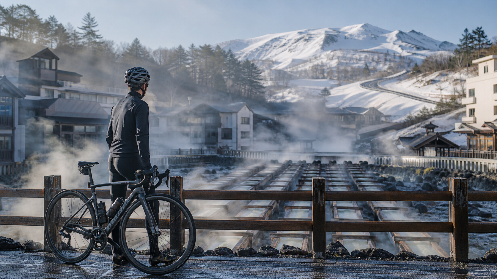
In the early morning at Kusatsu, the air carries the smell of sulfur. The Yubatake at the heart of the hot spring town is still sending up white steam, with wooden troughs channeling the scalding source water down in sections, the mist condensing into a blanket of white against the cold air of early spring’s lingering snow. I lean my bike to the side, watching this hot spring town—one of the so-called “Three Great Springs of the World” and boasting Japan’s highest spring output—come to life, thinking to myself: in a moment, I’ll climb from this haze all the way up to a volcanic highland at roughly 2,000 meters above sea level.
That was the first shock the Tour de Kusatsu-Shirane route gave me—it’s not an ordinary climb; it’s a journey from the steam of a hot spring town into a snowy highland. The route’s numbers aren’t extreme: approximately 12.1 kilometers, 957 meters of cumulative elevation gain, and an average gradient of 6.2%, ending at the Shirane Volcano parking lot at about 2,000 meters. But behind those figures lies a tapestry of Kusatsu’s hot spring vapor, the stunning views of the Shiga-Kusatsu Highland, the volcanic sulfur landscape, and the snow walls and frigid air that are only available during the lingering-snow season.
Some routes make you remember the numbers; some routes make you remember the smell. Kusatsu is the latter—you’ll forever recall that scent of sulfur and steam at the start.
In this article, I’m not going to talk about gear ratios and power output (that’s for another piece). I want to take you through this route’s geography, history, scenery, culture, and food in the first person, and explain why a cyclist should go out of their way to haul a bike into the mountains of Gunma for Kusatsu.
1. The Three Great Springs of the World: Geography and History of Kusatsu Onsen
To understand this route, you first need to understand the town of Kusatsu.
Kusatsu Onsen is located in Kusatsu-machi in northwestern Gunma Prefecture, and is regarded as one of Japan’s “hot spring meccas.” Alongside Arima and Gero, it is counted among the so-called “Three Great Springs of the World,” and what Kusatsu prides itself on most is its claim to Japan’s highest spring output—the source is so abundant that the entire hot spring town is practically “soaking in hot springs.”
- Yubatake: The landmark at the center of the hot spring town. Scalding source water gushes from underground and is channeled through a row of wooden troughs (yubune) to cool it down while also collecting the hot spring crystals known as “yu no hana.” The Yubatake discharges thousands of liters of hot spring water per minute, making it Kusatsu’s most iconic scene—especially dreamlike when lit up at night.
- Yumomi (stirring the hot spring): Because Kusatsu’s source water is extremely hot, the locals developed a tradition of stirring the hot spring with large wooden boards to cool it without diluting its quality, accompanied by the rhythm of the folk song “Kusatsu Yumomi Uta.” It has become a cultural performance unique to Kusatsu—a romance of turning “everyday wisdom” into a “cultural ritual.”
Kusatsu’s hot spring culture isn’t a backdrop; it’s the town’s very breath. When you stand by the Yubatake, watching the steam rise, smelling the sulfur, and hearing the melody of the yumomi song, you’ll understand: the starting point of this climbing route is itself a destination.
2. The Shiga-Kusatsu Highland Route: The Legendary Road to Japan’s Highest National Highway Point
The road climbing up from Kusatsu Onsen is part of a route famous throughout Japan’s cycling and driving communities—the Shiga-Kusatsu Highland Route (National Route 292).
This national highway, commonly called the “Shiga-Kusatsu Highland Route,” starts from Kusatsu Onsen, passes through the Shiga and Manza area, and runs all the way to Shibu Onsen in Nagano Prefecture, spanning about 43 kilometers. What it’s most renowned for is having Japan’s highest point on a national highway (around Shibu-toge, at approximately 2,172 meters). In other words, when you ride this road, you’re traveling along a section of “the highest national highway in Japan that you can drive.”
Our Shirane route climbs from the Kusatsu side up to the Shirane Volcano parking lot at about 2,000 meters. While it doesn’t reach the highest point at Shibu-toge, this stretch is more than enough to make you understand what it means for the landscape to “change seasons with elevation”:
- Lower elevation section: Leaving the hot spring town, the roadside is still forest and vegetation, and the sulfur smell gradually fades as you gain altitude.
- Mid elevation section: Trees thin out, the view opens up, and you can start looking back at the Kusatsu basin and surrounding mountains.
- High elevation section: Nearing Mount Shirane, vegetation becomes low or disappears entirely, replaced by volcanic sulfur terrain—bare rock, pale yellow sulfur crystals, desolate yet magnificent, like riding onto another planet.
The higher you climb, the quieter and more barren the world becomes. When the forest falls away behind you and all that’s left is the wind and the volcanic landscape, you feel a strange mix of solitude and vastness—that’s the unique reward of a high-mountain climb.
3. Mount Shirane and Yugama: The Emerald Green Crater Lake
Near the end of this route, the most breathtaking sight is Kusatsu-Shirane and its crater lake, “Yugama.”
Mount Shirane is an active volcano, and near its summit lies a crater lake called Yugama. What makes Yugama unforgettable is its color—the highly acidic water takes on a dreamlike emerald/milky green, set against the white volcanic ash surroundings like a gem embedded in a wasteland. This color comes from sulfur and minerals dissolved in the water, a painting composed by nature and geology together.
A word of caution: as an active volcano, Mount Shirane’s activity affects access and viewing in the surrounding area—this event was once canceled for a year due to volcanic activity, and the mountain area is also regulated according to volcanic alert levels. So if you ever get the chance to see Yugama with your own eyes, treat it as a gift that “nature has allowed you to see,” and approach it with reverence.
Standing at the finish line at about 2,000 meters, looking back at the entire slope you just climbed with your own legs, and ahead at the volcanic desolation and (if visible) the green of Yugama—in that moment, the 957 meters of climbing all becomes worth it.
What makes Yugama special isn’t just its color, but the fact that it’s direct evidence of a “living volcano.” The landscape of this highland—the exposed white rock, the pale yellow sulfur deposits, the barren wasteland where nothing grows—is all the result of volcanic activity sculpting it over the years. Riding through it, you feel keenly how small humanity is: everything here is determined by forces beneath the earth, and we are merely brief visitors, permitted to take a look.
For this reason, access and viewing around Mount Shirane have always been regulated according to volcanic alert levels. This event was once canceled for a year due to volcanic activity, and the opening and closing of the mountain area always prioritizes safety above all. So if on the day you come, Yugama happens to be shrouded in clouds, or certain areas are off-limits, don’t be disappointed—that’s the mountain reminding you that some scenery depends on fate, and on respect.
4. Seasonal Limited: The Lingering-Snow Season and the Snow Corridor
The Tour de Kusatsu is held in the early spring lingering-snow season, and this timing gives the route a seasonal magic hard to find elsewhere.
In spring, when the highland road has just reopened after being closed for winter, the roadside is lined with “snow corridors” formed by piled-up snow—tall walls of snow flanking the road, making you feel like you’re riding through a white passageway. This sight is only visible during the brief window of early spring’s lingering snow, right after snow removal is complete—truly “seasonal limited.”
Picture this: you start from the steaming hot spring town of Kusatsu, climb higher and higher into colder air, and finally ride into a highland road flanked by snow walls, your breath fogging white and blending with the remaining snow beside you. From heat to snow walls, this route takes you through an entire season in just 12 kilometers.
- Visual: The white steam of Yubatake → the fresh green of the forest → the volcanic ash white of the highland → the pure white of the snow corridor.
- Temperature: The warmth of the hot spring town → the heat of the mid-climb effort → the biting cold of the high-altitude finish.
- Smell: The intense sulfur at the start → the freshness of the forest → the thin, crisp air of the highland.
This multi-layered sensory experience is something an indoor trainer can never give you. That’s why I believe Kusatsu is worth a personal visit for anyone who loves cycling and travel.
To give you a clearer picture of this “season-changing-with-elevation” journey, here’s a table:
| Elevation Section | Visual | Temperature Feel | Smell/Sound |
|---|---|---|---|
| Start: Kusatsu Onsen | Yubatake white steam, hot spring town | Warm | Strong sulfur, yumomi song |
| Lower elevation forest section | Trees, fresh green | Heating up from climbing | Fresh, chain sound |
| Mid elevation open section | Looking back at Kusatsu basin and mountains | Starting to feel cool | Wind growing stronger |
| High elevation volcanic section | Sulfur wasteland, (when visible) Yugama green | Biting cold | Thin cold air, silence |
| Snow corridor | Pure white snow walls on both sides | Coldest | Quiet as wind is cut by snow walls |
The Snow Corridor Stretch
I want to write a bit more about the snow corridor. When you ride into that section flanked by towering snow walls, you get a strange sensation—as if all the color has been drained from the world, leaving only white walls, a gray road, and the white puffs of your own breath. The snow walls slice through the wind, and sometimes you’ll suddenly ride into an eerily quiet stretch where all you hear is the chain and your breathing; other times, a turn brings the cold wind rushing back in, reminding you that you’re on a highland nearly 2,000 meters above sea level.
What makes this sight so precious is its strict “best-before date.” It only appears in the brief window after the winter-closed road has been plowed open, but before the remaining snow has fully melted. Any earlier, and the road isn’t open yet; any later, and the snow is gone. You have to arrive in the right season, with the right weather, and under the right volcanic conditions to encounter it. Precisely because it’s so rare, that stretch of pedaling between the snow walls is something you’ll remember for years.
V. First Person: My Kusatsu Climb Memory
Allow me to use a personal narrative to give you a “feel” for this route.
When the starting signal sounded, I could still feel the lingering warmth of Yubatake’s steam on my face. The early section was a relatively gentle approach climb, with forests flashing by on both sides, and the sulfur smell gradually diluted by the highland’s cold air as altitude increased. I reminded myself: don’t rush; this is a 12-kilometer conversation, not a sprint.
Entering the middle section, the gradient stiffened. The road grew quiet—almost no sound except my own breathing and the whirring of the chain. I kept my eyes on the road ahead, pushing the altitude number up notch by notch at a steady cadence. When I looked back, the Kusatsu Basin and the surrounding peaks were already below me, and that grounded feeling of “lifting yourself to this height with your own legs” began to well up.
Past 1,500 meters, the air grew noticeably thinner. The same gradient demanded harder breathing. That’s the most honest thing about high-mountain climbing—it won’t give you more oxygen just because your will is strong; you can only accept, adjust, and keep going. I shrank my goal from “the finish” to “the next corner,” one corner at a time.
In the final two kilometers, the trees almost disappeared, replaced by volcanic wasteland and (if you’re lucky that day) faint highland colors in the distance. The wind grew stronger and colder, but the finish was ahead. When I finally rode into the Shirane Volcano parking lot at around 2,000 meters, the first thing I did wasn’t to celebrate—it was to quickly pull my windbreaker out of my pocket and put it on. The cold at high altitude is genuinely cold.
Then, I turned around and looked at everything I had just climbed.
The reward of a climb is never just the scenery at the summit, but that moment when you look back at the road behind you and say to yourself, “So I really could do it.”
VI. Along the Way and Side Trips: Turning Kusatsu into a Full Trip
After finishing this route, don’t rush off. The Kusatsu area deserves at least one extra day—turn it into a complete hot-spring highland journey.
Must-do experiences around the hot spring town:
- Stroll around Yubatake: See the steam by day, the illuminations by night. Yubatake is the heart of Kusatsu; take a slow lap around it.
- Yumomi performance: Watch the traditional performance where “Kusatsu Yumomi Uta” accompanies the stirring of hot spring water with large wooden boards, and feel how the people of Kusatsu turned daily life into culture.
- Hot spring bath: After climbing, soak your tired legs in Kusatsu’s source, which has Japan’s highest discharge volume—the perfect finale to this journey. Kusatsu Onsen is renowned for its water quality, and its acidic springs are highly effective at relieving fatigue.
Highland drives / extended routes:
- Shiga Kusatsu Kogen Route: If your energy and schedule allow, this national highway extends toward Nagano and leads to the highest point on Japan’s national highways (around Shibu Pass, approximately 2,172 meters)—a pilgrimage road for cyclists and motorcyclists alike.
- Volcanic highland scenery: The area around Mt. Shirane (subject to volcanic warnings and traffic restrictions) is an excellent spot for viewing volcanic terrain and sweeping highland vistas.
Local food tips:
As a long-established hot spring resort, Kusatsu’s hot spring street offers a variety of yumomi manju (steamed buns), local snacks, and eateries. I won’t name any specific shops here (since establishments come and go), but I suggest you adopt a “go with the flow” mindset—wander around Yubatake, and when you see a steaming hot spring manju, buy one and eat it while it’s warm. After climbing the mountain, soaking in the hot spring, and taking a bite of a freshly steamed manju—that’s a very tangible happiness unique to Kusatsu.
Wandering the hot spring street is itself a pleasure. Stone-paved paths, wooden buildings, steam rising here and there, and the faint sulfur smell in the air create a very “Japanese hot spring town” atmosphere. During the lingering-snow season, this gains an extra layer of crisp clarity—hot springs, cold air, white snow, warm lights—a contrast that’s just right. You’ll find yourself slowing down, letting the tension from the climb loosen bit by bit along this street.
Accommodation and itinerary suggestions:
- Base yourself at Kusatsu’s hot spring street: Whether you’ve come specifically to climb Mt. Shirane or want to explore the Shiga Kusatsu highlands, staying near the hot spring street is most convenient—you can soak, eat, and shop just steps from where you finish riding.
- Stay at least one night: A highland hot spring town like this deserves more than a day trip. Stay one night, experience Yubatake lit up in the evening and the steam that hasn’t dissipated by early morning—your memory of Kusatsu will be far more complete.
- Schedule your ride during stable weather: Highland weather is changeable. If you have flexibility, try to plan your Mt. Shirane climb for the half-day with the most stable forecast and best visibility—safer, and the scenery is at its finest.
VII. For Those Who Want to Come: Seasons, Mindset, and a Little Romance
If this route has moved you and you want to fit it into your itinerary, here are a few things I’d like to share:
- About the season: This is a lingering-snow highland climb; cold is its essence. Bring ample warm gear, and don’t let hypothermia ruin a wonderful experience. And precisely because it’s cold, challenging, and season-limited, the awe you feel when you see the snow corridor and volcanic highlands is irreplaceable.
- About the volcano: Mt. Shirane is an active volcano. Be sure to check the current volcanic alert level and road access information before you go. Nature’s rules always take precedence over our plans, and that reverence is part of this journey.
- About mindset: Kusatsu is not a route for “setting a PR.” It’s a route for “reading a hot spring town and a volcano with your body.” Slow down a little, take an extra look at the steam over Yubatake, take an extra breath of the highland air—you’ll leave with far more than a time on the clock.
I’ve always believed that the best cycling routes are the ones that make even non-cyclists want to go after hearing about them. Kusatsu is exactly that—it has one of Japan’s three famous springs, the country’s highest discharge volume, an emerald-green crater lake, the legend of the highest point on a national highway, and a season-limited snow corridor. And you happen to have a pair of legs that can carry you to all of it.
So, find an early spring when the snow hasn’t yet melted, bring your bike, your warm layers, and a heart willing to slow down—and go to Kusatsu. Set off from the warmth of Yubatake, pedal all the way, until you ride into the sky of that volcanic highland.
One day you’ll realize that what you remember isn’t how exhausting that 957-meter climb was, but the sulfur smell at the start, the mountains you looked back on mid-climb, and that cold yet utterly clear breath of air at the summit. That’s Kusatsu—the warmth it leaves on a rider.
VIII. Yubatake Is More Than a Sight: The Life Philosophy of Kusatsu Onsen
Stay a few more days, and you’ll discover that Kusatsu’s hot spring culture runs far deeper than the Yubatake on a postcard.
The people of Kusatsu approach hot springs with a wisdom of “coexisting with high temperatures.” The source water is extremely hot—bathing in it directly would scald you—so their ancestors invented yumomi (hot spring stirring): using long wooden boards to stir the source water back and forth like rowing a boat, lowering the temperature while preserving the water quality without diluting it with cold water. Paired with the generations-old “Kusatsu Yumomi Uta,” this act gradually evolved from a cooling labor into a performance and a cultural identity.
I particularly enjoy the time spent standing by Yubatake watching the steam. The hot spring wells up from underground, flows slowly down through a series of wooden troughs, and the white steam is especially thick in the cold air of the lingering-snow season. A pale yellow deposit of “yuno hana” (hot spring crystals) accumulates on the inner walls of the troughs—living proof that Kusatsu’s source is active. You come to realize: the heartbeat of this town is this never-ceasing flow of hot spring water. The highest discharge volume in Japan isn’t just a marketing phrase; it’s the very reason Kusatsu exists.
- Yubatake by day: Steam, sulfur smell, travelers coming and going—lively and down-to-earth.
- Yubatake at night: Once lit up, the steam is dyed into something dreamlike by the glow, quiet as a painting.
- Yubatake after a climb: When you’ve conquered Mt. Shirane with your legs and return here to soak, Yubatake is no longer just a sight—it’s a place to “come home” to.
This rhythm of “first conquer a mountain with your body, then reward yourself with a hot spring” is what makes Kusatsu most enchanting for cycling travelers. Your fatigue has a place to rest, and your effort has a hot spring to reward it.
9. Placing Kusatsu on the Larger Map: The Cycling Puzzle of the Jōshin’etsu Highlands
If you’re willing to look further afield, Kusatsu is actually the gateway to an entire “Jōshin’etsu Highlands cycling territory.”
The Shiga Kusatsu Route (National Route 292) extends from Kusatsu toward Nagano Prefecture, passing through the Shiga and Manza area before finally reaching Shibu Onsen in Nagano Prefecture, spanning approximately 43 kilometers in total. Along the way, it includes the highest point on a national route in Japan (around Shibu Pass, at an elevation of approximately 2,172 meters), making it a pilgrimage road in the hearts of countless cyclists and motorcyclists. In other words, the Shirane Mountain route we’ve covered here is really just the “opening chapter” of this legendary national route.
Imagine a more advanced approach: using Kusatsu Onsen as your base, ride the Shirane Mountain route on day one, then soak in the hot springs to recover; if your fitness and the weather allow, and the road is open, take on the longer stretch toward Shibu Pass and stand in person at Japan’s highest national-route point. This style of travel—“camping out in a hot-spring town and conquering the highlands day by day”—is the perfect combination of cycling, onsen, and breathtaking scenery.
Of course, the prerequisite for all of this is always safety and season. These highland roads are closed in winter and only gradually reopened after snow removal in early spring, and since Mount Shirane is an active volcano, access conditions are adjusted according to volcanic warnings. So leave the decision of “whether you can ride” to the official information at the time, not to your itinerary.
The mountains will not yield to anyone’s plans. Knowing how to come in the right season, under the right conditions, is itself a form of cycling maturity.
10. On “Slowness”: What This Route Taught Me
Finally, I’d like to talk about something unrelated to performance.
I’ve ridden plenty of climbing routes, many of them for the sake of beating a PB, for the numbers on a results sheet. But Kusatsu offered me a completely different experience. Every element here—the steam of Yubatake, the vistas of the Shiga Kusatsu Highlands, the desolation of volcanic sulfur, the emerald green of Yugama, the pure white of the snow corridor—reminds you: slow down a little, and you’ll actually see.
If, in the third section, when you’re gasping for air and it hurts the most, you’re willing to lift your head and take a look at the mountains behind you; if, at the finish line, when you can barely catch your breath, you’re willing to stay thirty extra seconds to feel that cold highland air; if, after you finish the climb, you’re willing to sit a while longer by Yubatake and watch the steam rise slowly—then what you take away will be far more than a finishing time.
Kusatsu is not a route to be “conquered”; it’s a route to be “encountered.” You’ll encounter a hot-spring town with Japan’s highest spring output, a legendary road leading to the highest point on a national route, an active volcano with an emerald-green crater lake, and, among the snow walls of the lingering-snow season, a version of yourself willing to slow down for the scenery—yet still gritting your teeth and climbing to the end.
So I’d like to end this story on one image:
You’ve just ridden into the Shirane Volcano parking lot, at an elevation of about 2,000 meters. The wind is cold, so you quickly throw on a windbreaker. Then you turn around, looking at the slope you just earned with 957 meters of climbing, looking toward the direction of the Kusatsu Basin in the distance, looking up at a sky made all the more vast by the volcanic highlands around you.
In that moment, you’re not thinking about your time. You just take a deep breath of that crisp air, and smile to yourself.
This is Kusatsu. From the heat of Yubatake to the sky above Mount Shirane—a gentleness that belongs only to those who arrive on their own two legs.
Related Reading
- Tour de Kusatsu Shirane Practical Guide: A Breakdown of the 12.1 km / 957 m Climb / 6.2% Average Gradient Snow-Season Route
- Taitung City to Zhiben Hot Springs Route: A Leisurely Hot-Spring Cycling Route in Southern Taiwan
- Riding Around to the Back of the Mountain: Ura-Rokko, a 7.7 km Ride Through Hydrangeas, Deep Forests, and a Thousand-Year-Old Hot Spring
- Taiwan Hot-Spring Cycling: Combined Soaking and Riding Itineraries in Beitou, Wulai, and Zhiben
秘境雪場 日本 八甲田 冰樹探險與滑雪體驗 ft. Q老師 & 運動生活
7 年前
台中大雪山 膏王領騎 震到都沒畫面了 公路車
5 年前
日本島波海道 EP1 / 五大絕景路線之一! / 私房溫泉 x 豪華單車客棧 / 今治 to 大三島 / 公路車 / CT Yeh
2 年前
2025 乘鞍 KOM 登山賽挑戰實錄 / 日本公路最高 ! 賽前探路篇 / 比富士山厲害,無敵絕景!/ 40週年 / 中文YT首發 / 公路車 / CT Yeh #乘鞍ヒルクライム
10 個月前
小野田真的存在!日本赤城山爬坡公路賽 台灣首發團完全實錄 | 頭文字D真實賽道! | 看完東奧自行車賽後好想再去騎一次啊! | 公路車 | CT Yeh
4 年前
虎豹潭!日本老師來台一日約騎 台灣車友熱情招待私房路線 / CT Yeh
20 天前
太平山單車員工旅遊 | 這樣玩CP值最高!| 公路車
5 年前
阿里山塔塔加 兩倍特濃版!全新隧道開通! 進喔!公路車 | CT Yeh
3 年前