Nenggao Cross-Ridge Trail: A Century-Old Path, the "Light Shines Upon Eight Directions" Monument, and the Power Line That Lit Up Taiwan
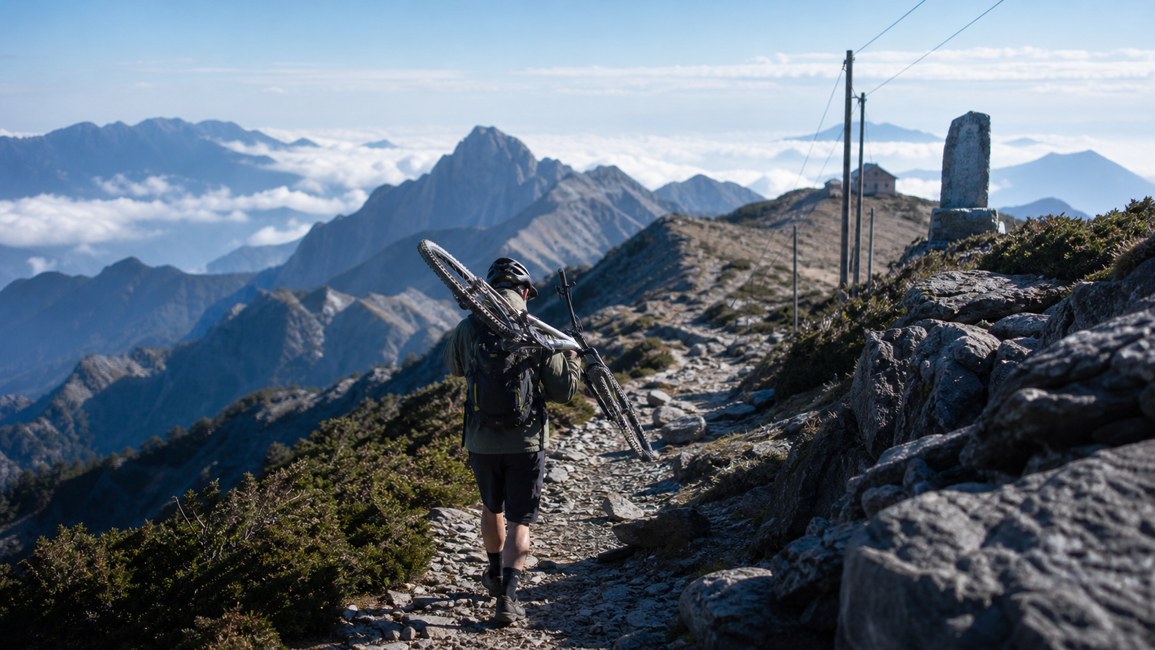
Some roads, you ride to a certain point, and you have to hoist the bike onto your shoulder, or simply stop and finish the rest on foot. The western section of the Nenggao Cross-Ridge Trail is exactly that kind of road. From the Tunyuan trailhead (elevation approx. 1,860 m) to Tianchi Lodge (approx. 2,860 m), the stats read about 12.9 km with roughly 1,101 m of climbing—but behind those numbers lies not a paved road for satisfying pedal strokes, but a century-old trail that has carried the weight of tribal migrations, police control roads, and the east-west power transmission lifeline.
This article isn’t about pacing. What I want to introduce you to is the story of this trail: how the Seediq tribal paths became a Japanese-era cross-ridge route, why the four characters “光被八表” (Light Shines Upon Eight Directions) are carved into the central mountain ridge, and how a power line that once lit up all of eastern Taiwan stretched across these high peaks. This is a ride and a walk into the depths of history.
On the day of departure, I set up my bike in the early morning in Puli. Heading from the basin into the mountains, the elevation climbed steadily, the air grew thinner and cooler, and the sounds of the town gradually gave way to streams and wind. I’ve always felt that the road toward Nenggao Cross-Ridge Trail carries a special sense of ritual—you’re not simply riding a climb; you’re heading toward a ridge sealed away in layers upon layers of history. With every meter gained, time seems to recede a little further, back to an era when hunters speaking their native tongue still walked these mountains.
Some mountains give you scenery, some give you exhilaration, but the Nenggao Cross-Ridge Trail gives you “weight.” It’s a weight that, as you ride, suddenly makes you go quiet.
A Road That Has Been Walked for a Century
The Nenggao Cross-Ridge Trail wasn’t originally a “road” but a “tribal path”—a traditional route used by the Seediq people for migration, trade, and travel between the eastern and western sides of the Central Mountain Range. The western section lies in Ren’ai Township, Nantou County; the eastern section in Xiulin Township, Hualien County. An ancient trail connects Taiwan’s east and west along a ridge at nearly 3,000 meters in elevation.
During the Japanese colonial period (around 1917–1918), this tribal path was carved into the “Nenggao Cross-Ridge Police Control Road,” Taiwan’s first east-west trans-mountain road built to a width of 2 meters. From a path of tribal migration to a colonial-era police artery—every stretch of this ancient trail bears the footprints of different eras. When you travel along it today, you’re treading not just on dirt and gravel, but on layer after layer of Taiwan’s history.
I often imagine how this road was carved out with pickaxes and shovels in an age before asphalt and machinery. Two meters may not seem wide today, but amid towering peaks and steep cliffs, without modern tools, cutting such a trans-mountain road into the sheer mountainsides was an immense undertaking. And even earlier, the Seediq people had already followed the trail’s precursor to cross the Central Mountain Range, moving, trading, and intermarrying between the east and west. A road first walked into existence by a people’s feet, then rewritten again and again by the times.
That’s why the Nenggao Cross-Ridge Trail is not just a “route” but a condensed history of Taiwan. It begins in the living domain of indigenous peoples, passes through the extension of colonial power, and finally becomes the stage for the power transmission lifeline in the postwar era. On the same ridge stand people of different eras, different ethnicities, and different purposes. And today, I am merely the newest and most insignificant passerby in that long procession.
Tunyuan Trailhead: The Divide Between Wheels and Feet
For riders, the western section of the Nenggao Cross-Ridge Trail has a very clear dividing point—Tunyuan Trailhead. The industrial road climbing up from Puli, Wushe, and Lushan reaches its practical end for vehicles here. At approximately 1,860 meters in elevation, Tunyuan Trailhead is the gateway for hikers starting the Nenggao Cross-Ridge Trail or the Qilai Nanhua route, and it’s also the place where riders should stop their bikes and shift their mindset.
Above Tunyuan, the path becomes a hiking trail. A handful of mountain bike riders do carry their bikes and ride-and-walk the entire route, but that’s “trail riding”—dismounting on steep descents, pushing through muddy ruts, crossing multiple landslide sections, requiring mountain entry applications, park permits, and thorough preparation for high-mountain risks. For the vast majority, Tunyuan Trailhead is the best finish line for this ride: here, you complete a high-elevation industrial road climb and stand at the threshold of a century-old trail.
To head toward Tianchi or Guangbei Babiao, prepare your feet—that’s a story from another world.
I really like the word “divide” applied to this road. In life, we often can’t figure out where we should stop—work, desires, stubbornness, always thinking just a little more, a little further will do. But this mountain, with a place called “Tunyuan,” tells you plainly: this is where it ends. Going further isn’t impossible, but it requires a different kind of preparation, a different resolve, a different pair of feet. Recognizing that line and being willing to stop at the right place is actually a mature form of wisdom.
Standing at Tunyuan Trailhead, leaning my bike aside, watching the trail disappear into the deep forest, I felt a rare sense of groundedness. I knew I’d completed the part belonging to wheels, and that what lay above wasn’t for me today. Not every arrival needs to be proven by “conquering it all.” Sometimes, knowing when to stop takes more courage than pushing forward with all you’ve got.
Tianchi Lodge and Qilai Nanhua: A Sanctuary for Hikers
Past Tunyuan, about 13 km further up, sits Tianchi Lodge at approximately 2,860 meters. This is the most important high-mountain base on the Nenggao Cross-Ridge Trail and the staging ground for the “Qilai Nanhua” (the combined Qilai South Peak and Nanhua Mountain) hundred-peak route—hikers commonly start from Tunyuan, overnight at Tianchi Lodge, and summit the next day with light packs.
The high-mountain meadows, sea of clouds, and starry skies around Tianchi Lodge are a sacred realm in the hearts of countless hikers. Setting out from the lodge at dawn, watching the sun rise from the sea of clouds and paint the ridgeline of Qilai South Peak in gold—that grandeur belongs only to those who venture deep on foot. For riders, even if your wheels only reach Tunyuan, simply knowing that a high-mountain paradise lies just above is enough to fill this ride with longing.
Qilai Nanhua has become the “first hundred-peak” route for many because it’s relatively accessible—starting from Tunyuan, overnighting at Tianchi Lodge, then making a light round trip to Qilai South Peak and Nanhua Mountain the next day. This rhythm of itinerary lets many people experience for the first time what it’s like to “sleep above the sea of clouds.” And the starting point of it all is precisely the Tunyuan Trailhead where riders stop their wheels. You and the hikers part ways at the same threshold: they ascend into the world of the trail, while you tuck the imagination of these high mountains into your pocket and carry it back down.
During my time at Tunyuan, I watched a group of hikers with large backpacks gear up and set off toward the trail, their figures quickly swallowed by the forest. At that moment, I felt a touch of envy and a touch of relief. Envy for the sea of clouds and stars they were about to see; relief in knowing clearly that it wasn’t a place for wheels. Some beauty, by nature, demands a different approach, a different pair of feet, to be worthy of it.
Radiant Light Across the Eight Borders: The Legend of a Power Line
At approximately the 15.5-kilometer mark of the Nenggao Cross-Ridge Historic Trail, at an elevation of about 2,890 meters on Nenggao Pass (Nenggao Yakou), stands a renowned stone monument—the Guang Bei Ba Biao Stele (Stele of Light Reaching the Eight Borders). It is a monument to one of Taiwan’s great post-war engineering feats.
In the 1950s, Taiwan constructed an east-west power transmission line spanning the Central Mountain Range to deliver electricity from the east to the west. The highest point of this line reached 3,000 meters in elevation, making it the highest transmission line in East Asia at the time and the first post-war power lifeline to cross the Central Mountain Range. The project was completed in 1953. To commemorate this feat of “sending eastern power westward,” a stele was erected at Nenggao Pass, inscribed with eight characters personally written by then-President Chiang Kai-shek: “光被八表、利溥民生” (Guang Bei Ba Biao, Li Pu Min Sheng)—meaning, “May the light shine upon the farthest reaches of the eight directions, and may its blessings extend to all the people.”
Imagine this: in an era without helicopters and with limited machinery, engineers had to carry heavy transmission tower equipment step by step up to the 3,000-meter ridgeline of the Central Mountain Range, erecting power lines across a natural fortress. This line lit up the lights of post-war western Taiwan and turned “impossible” into “possible.” The Guang Bei Ba Biao Stele stands as a testament to that determination.
It should be noted: this stone stele was struck and broken during the April 3, 2024 Hualien earthquake and the January 2025 Chiayi Dapu earthquake. It now stands scarred and fractured at the pass, and in a way, it has become another testament to Taiwan’s earthquake-prone land—a place where humanity and nature are in constant dialogue.
I have always had complex feelings about this. A stele erected to commemorate an engineering triumph of “human will conquering nature,” ultimately cracked by the force of the earth—this is almost like a fable. It reminds us: no matter how hard we try to send power across the Central Mountain Range and bring light to all directions, this island is ultimately alive, and it moves. Earthquakes, typhoons, torrential rains—they repeatedly reshape the face of these mountains and repeatedly remind us to be humble. That fractured stele is therefore more honest than it was when intact—it simultaneously carries human will and nature’s response.
If you ever make it there, what you will see is not a gleaming new monument, but an old stele bearing wounds, yet still standing on the ridgeline. Please don’t be disappointed. Its fractured form is precisely Taiwan’s truest face: in the repeated tug-of-war between humanity and nature, it keeps standing—effortfully, stubbornly.
Hot Springs and History Along the Way: Wushe and Lushan
Before reaching Tunyuan, the route passes through Wushe and Lushan. Wushe is the site of the historic “Wushe Incident” in Taiwan’s history—the tragic and heroic uprising of the Seediq people against colonial rule—a history that lends this place name a heavy weight. Lushan is renowned for its hot springs, a rare hot-spring settlement along the route, making it a suitable rest stop before or after the ride. Further out, Cingjing Farm is a popular side-trip destination in the area.
When you ride through Wushe, knowing what once happened in these mountains, you will view everything before you with a more humble and quieter heart. This road connects not just scenery, but one memory after another of this island of Taiwan.
I slowed down in Wushe. Not because of the steepness of the slope, but because of my mood. It is hard to ride through a place with a lighthearted attitude once you know what happened there. The weight of history naturally sinks into your cadence, making you fall silent without meaning to. This is what makes riding deep-mountain routes so special—it forces you to slow down, slow enough to read the land’s memories page by page.
Not far past Wushe lies Lushan Hot Spring. This is a rare hot-spring settlement along the route, where steaming thermal water wells up from beneath the earth—a warm comfort in this cold, high mountain region. Many riders treat Lushan as a rest stop, soaking in the hot springs to loosen their legs after the climb. And further out, Cingjing Farm’s alpine meadows, sheep, and European-style lodgings are the most popular side-trip destinations in the area, ideal for scheduling before or after the journey to add a softer margin to a route defined by hard climbing.
Side-Trip Stops Along the Route
| Location | Highlights | Best Arranged As |
|---|---|---|
| Wushe | Historic site of the Wushe Incident; a quiet historical place | Slow down and pay respects when passing through |
| Lushan Hot Spring | A rare hot-spring settlement along the route | Soak before/after the ride to relax the legs |
| Cingjing Farm | Alpine meadows, sheep, European-style lodgings | A softer side trip before or after the journey |
| Tunyuan Trailhead | End of the ride; gateway to the historic trail | Summit photo, resupply, and keeping warm |
Note: The above is a route concept. Actual accessibility, business operations, and road conditions vary from year to year. Please verify for yourself; do not treat this as a guarantee.
Nenggao Through the Seasons: A Mountain with Four Different Faces
The same road will give you completely different experiences in different seasons. This is what makes deep-mountain routes so fascinating—and so deserving of reverence. What you face is not a fixed road, but a mountain whose mood shifts with the seasons.
In spring, mountain cherries and various wildflowers dot the lower elevations with green, and the air carries a freshness of all things awakening—but afternoon clouds and mist also begin to stir. In summer, it is the greenest season, with vegetation in full flourish; however, afternoon thunderstorms are also most frequent, and the weather can change in an instant, putting your discipline of “starting early” to the test. In autumn, the sky is often especially high and clear—for many, the most comfortable alpine season, with excellent visibility and magnificent seas of clouds. In winter, the high elevations turn bleak, temperatures can drop to levels that catch you off guard, and even icing is possible—the season demanding the most warmth and caution.
The time I went, the mountain was oscillating between clouds and clear skies. One moment, a crisp ridgeline under blue skies; the next, white mist surged up the entire valley, shrinking the world to a few meters in front of you. That unpredictability—you could call it danger, or you could call it a living, breathing kind of beauty. But either way, it says the same thing to you: before this mountain, set aside your overconfidence and bring your full preparation.
Note: The above is a general impression of alpine seasonal patterns. Actual weather varies every year and changes extremely quickly. Always check the latest forecasts and road conditions before departure; never substitute seasonal impressions for on-the-ground judgment.
What This Road Means to Riders
What the western section of the Nenggao Cross-Ridge Historic Trail teaches riders is “knowing your limits.” It is not a road for showing off or setting records—it tells you clearly at the Tunyuan Trailhead: this is the limit of wheels; beyond this point, go on foot, with permits, experience, and reverence. Knowing when to stop in the right place is a wisdom more important than climbing higher.
For riders, the high-elevation industrial road that can be ridden is a solid challenge to physical fitness and willpower; while the historic trail beyond Tunyuan is a reminder—some beauty requires you to set down your wheels, slow your pace, and approach it in the most primal way. The value of this century-old trail lies not in how many kilometers you conquered, but in how it lets you read a mountain, a slice of history, and a humility of coexistence between humans and nature.
On the day I descended, I kept thinking about this. Riders of our generation are too accustomed to measuring everything in numbers—distance, elevation gain, average speed, power, rankings. These numbers are not wrong; they are part of the passion. But the Nenggao Cross-Ridge Trail reminded me that there are things numbers cannot measure: how long a road has been traveled, how many footsteps it has carried, how many silent stories are buried within it. When you turn off your bike computer and read the road with your heart, what you gain will last longer than any PB (personal best).
What this road taught me, in fact, is a “sense of time.” The Seediq tribal paths, the Japanese-era police routes, the post-war power lines, the stele cracked by recent earthquakes—all of these are layered on the same ridgeline. Compared to such a timescale, my ride was but a fleeting moment. Yet it is precisely this “smallness” that made me feel an unprecedented groundedness on the pedals. It turns out that understanding your own smallness is also a kind of gain.
Side Trips and Reminders
- Tunyuan Trailhead: The practical end of the ride; the threshold of a century-old trail.
- Tianchi Lodge, Qilai Nanhua: Alpine sanctuaries for hikers; require mountain entry permits and thorough preparation.
- Guang Bei Ba Biao Stele: Monument to the east-west power transmission project (damaged by recent earthquakes).
- Wushe, Lushan, Cingjing: Historical, hot-spring, and farm side-trip stops along the route.
- Safety and Regulations: Beyond Tunyuan, mountain entry and park permits are required; alpine weather is highly variable and the geology is fragile. Always confirm the latest access and safety conditions before departure.
One Road, Two Lineages Meet
I’ve often thought since that the most fascinating thing about the Nenggao Cross-Ridge Trail might not be its elevation, but the way it layers two completely different kinds of “roads” on top of each other—one is the tribal path forged by the feet of indigenous people, and the other is the police road and engineering route later planned and constructed by state power. The former had no blueprint; it was generations of people, drawing on their understanding of the mountains, who walked out the most sensible route. The latter was surveyed, staked out, and blasted into existence, carrying explicit political and engineering purposes.
But what’s interesting is that these two paths ultimately follow almost the exact same ridgeline. This perhaps says something: no matter what purpose you carry into the mountains, the terrain’s own logic will eventually guide people from different eras onto similar paths. The routes chosen by the indigenous people were often the most efficient, safest, and most sensible ones—no matter how precisely later survey teams calculated, they still couldn’t bypass this mountain wisdom that had already been proven over time.
Riding on a road like this, you’re simultaneously treading on two kinds of historical logic: one is the wisdom of living with the mountains, the other is the engineering will to conquer and connect. They don’t negate each other; rather, like two strands of rope twisted together, they form what is today’s Nenggao Cross-Ridge Trail.
Nenggao Through a Guide’s Eyes
I happened to meet a guide at Tunyuan who was preparing to lead a team up to Tienchi Lodge. Seizing a gap while he was packing his gear, I chatted with him briefly. He said he’d walked this trail countless times, but every time he brought a new group up and saw the expression on someone’s face when they first saw the sea of clouds, he still felt it was worth it. “Many people think mountain climbing is about challenging your body,” he said. “Walk it long enough and you’ll realize it’s actually about coming to terms with your own patience and fear. The mountain won’t lie to you—whatever you’ve prepared, that’s exactly what it gives back.”
I’ve remembered that line ever since. Perhaps it applies not just to mountaineering but to cycling as well—this road won’t go easy on you just because you’re careless, and it won’t deliberately make things harder because you’re too nervous. It simply and honestly lays out the results of your preparation before your eyes. This “honesty” might be exactly what makes deep-mountain routes so captivating and so awe-inspiring.
Power from East to West: More Than Just a Line
The east-west transmission line behind the Guangbei Babel Monument deserves a bit more attention to understand its weight. In 1950s Taiwan, the electricity supply and demand between the eastern and western parts of the island were unbalanced. Moving power from one side to the other required a line that truly crossed the Central Mountain Range. In an era of limited machinery and rugged mountain trails, this was not merely an engineering problem—it was nearly a prolonged tug-of-war with the terrain.
Imagine an entire workforce and mountain of materials, carried by people and pack animals, step by step up to a ridgeline near three thousand meters; every tower foundation was painstakingly built up bit by bit under extreme terrain and weather conditions. After this line was completed, its significance went far beyond the two words “transmitting power”—it connected eastern and western Taiwan in an energy network for the first time, and in a sense, it symbolized the island’s postwar effort to stitch itself back together.
Today, when we flip a light switch, we hardly think about the line that once crossed mountains and ridges to make it possible. But when you stand at Nenggao Pass yourself, looking at that monument, you suddenly realize: convenience never comes out of thin air—it is always built from the sweat of a certain era, of a certain group of people. This is why I feel the Guangbei Babel Monument shouldn’t be just a “check-in spot.” It deserves a few extra minutes of your time to quietly reflect.
For Those Preparing to Go: A Few Reminders
If reading this story has stirred in you the urge to go see it for yourself, I’d like to offer a few reminders—not to dampen your spirits, but in the hope that you’ll set out with a more complete mindset.
First, this is a journey that demands humility. The industrial road below Tunyuan is already a solid mountain climb, and the historic trail above Tunyuan requires professional mountaineering preparation. Be clear about the boundary between the two; don’t let a momentary impulse make you “casually” step onto the trail. Second, mountain weather is the true master of this road. Be sure to check the latest forecasts and road conditions before departing, and don’t let past impressions override present judgment. Third, and most importantly—slow down. Not just for safety, but to give yourself the chance to truly “see” this road. It carries too many stories to be read at anything but a slower pace than usual.
The Nenggao Cross-Ridge Trail is not a road for setting records. It’s more like a history textbook spread open across the Central Mountain Range, page after page, waiting for those willing to slow down and turn them.
Conclusion
The western section of the Nenggao Cross-Ridge Trail belongs half to wheels and half to feet; half is the mountain industrial road before you, and half is the century-old trail history stretching behind you. It begins as a Seediq tribal path, passes through the Japanese-era police road, leads to the transmission lifeline that once powered eastern and western Taiwan, and finally rests on the ridgeline carved with the words “Guangbei Babel.” For riders who know to stop at Tunyuan and who hold the mountains in reverence, this road offers not the thrill of conquest, but a weighty understanding—about this island, about these mountains, and about the wisdom of “knowing when to stop.”
If you ever decide to come, don’t rush to treat it as a record to beat. Slow down a little. Pause at Wushe for its heavy history, let the hot springs at Lushan loosen your legs, and at Tunyuan lean your bike aside and look up at the ancient trail disappearing into the dense forest. You’ll find that the real reward of this journey isn’t on your cycling computer—it’s the quietness and humility that take root in your heart.
The mountain will always be there. It has stood from the era of the Seediq people to the present, and it will continue to stand, watching generation after generation come and go. What you can take away is the weight it gives you—a weight that will make you remember, every time you step on the pedals afterward, that “some roads are meant to be understood, not conquered.” This, then, is the Nenggao Cross-Ridge Trail.
Related Reading
- Nenggao Cross-Ridge Trail West Section Guide: Tunyuan Trailhead—The End of Wheels, The Beginning of Feet
- Southern Cross-Island Highway Westbound: From Meishan to Tianchi, A Ride Through Resilience, Bunun Forests, and a Lake in the Clouds
- A Volcanic Road with 1,300 Years of Hot Springs: Nasu-Tōgenocha’s Onsen, Legends, and Wilderness Riding
- Sacred Trees and an Alpine Lake in the Mist: A Pilgrimage Ride on Daxue Mountain, Turning Elevation into a Practice
嘉義大埔、阿婆灣挑戰賽,美到以為在日本!ft. 環騎5 Cool 西拉雅188 / 公路車 / CT Yeh
7 個月前
4K單車實境) 舊陽金P字道 第1P 仰德大道至小油坑 誤跟武嶺神人們 被拉爆爽飛天 Taiwan Cycling Climb Route Recommend
7 年前
大武山20%魔王陡坡【JJSC南台灣遊騎Day2】!屁股真的要裂開了...凡士林抹滿也沒用?神秘金教堂還有超便宜夜市
3 個月前
雙十節的溫腥感人約騎,升旗到升天一次滿足 | 公路車 | 鳳山寺 | 米粉坡
6 年前
新竹羅平 x 天湖部落 大禹嶺級變態陡坡! 4K超高畫質 空拍 | 公路車
5 年前
觀霧 變好騎了! | 北高車友爆笑大會師 | 公路車 | 單車旅遊 Taiwan Cycling Route GuanWu
6 年前
台北闊瀨陡坡 騎旅 / 日本單車雜誌編輯車友臨時加入!/ 髮香才是最強的 / feat. 北迴歸線小隊 / 公路車 CT Yeh
6 個月前
藤枝二集團 單車行 Day1 | 南部小武嶺 | 爬坡爬到罵罵叫 | JJSC | 公路車 | CT Yeh
3 年前