Southern Cross-Island Highway Eastbound: A Road Paved with Lives, a Cloudtop Pilgrimage After 13 Years of Closure
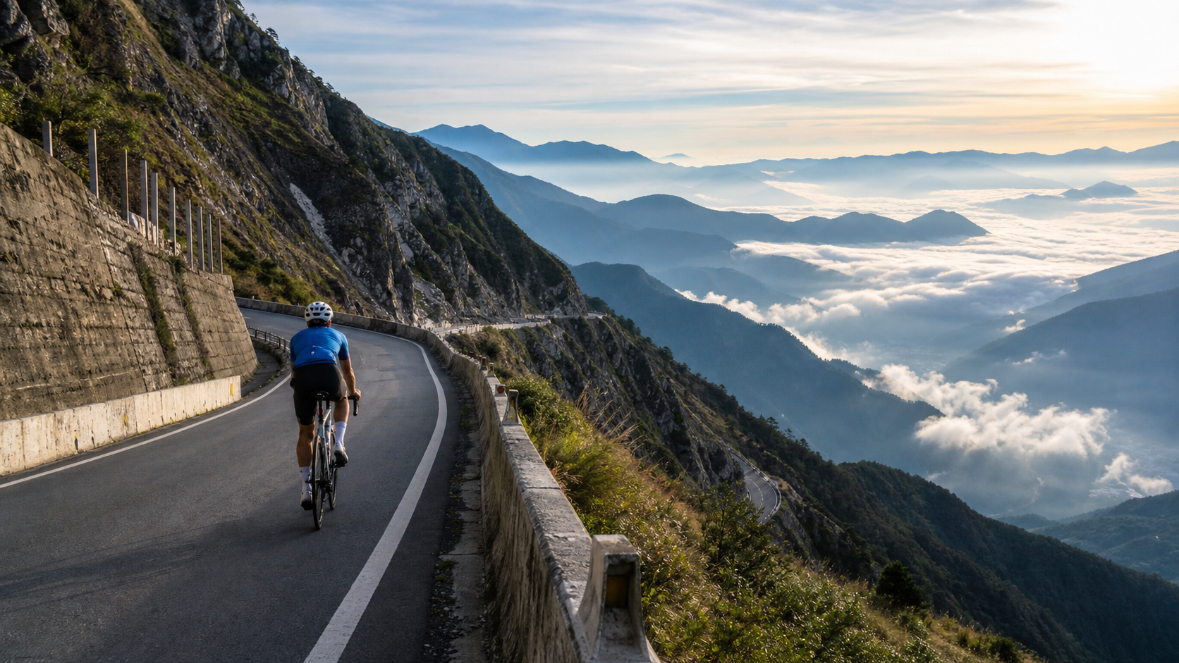
A Highway Paved with Lives
Before I turned my handlebars toward the eastern section of the Southern Cross-Island Highway at Chulai, I kept reminding myself of one thing: this road is not just a set of numbers—48.38 kilometers, 2,074.6 meters of elevation gain. It is a highway paved with lives.
The predecessor of the Southern Cross-Island Highway was the “Guanshan Cross-Mountain Trail” from the Japanese colonial era, a mountain path carved out for indigenous policing and defense, winding through the towering peaks of the Central Mountain Range. In the modern era, construction officially began on this road in July 1968. The engineering crews faced Taiwan’s most formidable Central Mountain Range terrain—without the aid of modern heavy machinery, without precise geological surveys, armed only with manpower and explosives, chipping away inch by inch at sheer cliffs to shape the rudimentary outline of a road. The project spanned 4 years and 4 months, finally opening to traffic on October 31, 1972. During that time, 116 workers lost their lives in the line of duty, their lives forever left behind in these mountains.
Today, at Tianchi along the Southern Cross-Island Highway, stands the Changqing Shrine, a quiet memorial to those 116 pioneering road-builders. Anyone who rides this road and is willing to pause at Tianchi and step into the shrine will discover that every inch of asphalt they’ve pedaled over was once bought with someone’s life. In 1994, the Southern Cross-Island Highway was fully paved with asphalt along its entire length, designated as Provincial Highway 20, totaling approximately 203.982 kilometers, making it one of the few roads in Taiwan that traverses the Central Mountain Range, connecting the east and west coasts.
I often wonder how many stories a road must carry before it can be called “a road with a soul.” For the Southern Cross-Island Highway, the answer is clearly yes. It is not merely a piece of transportation infrastructure; it is a microcosm of Taiwan’s history—of people battling nature, coexisting with the terrain, and even confronting life and death. When I ride this road, the feeling is utterly different from riding other touristy, popular routes—every curve, every retaining wall seems to tell a story unknown to the world.
The Wounds of Morakot and Thirteen Years of Waiting
If the birth of the Southern Cross-Island Highway was an epic of engineering written in blood and tears, then Typhoon Morakot in 2009 was the deepest scar this road has ever borne.
In August of that year, Typhoon Morakot struck Taiwan. In just five days, rainfall along the Southern Cross-Island Highway exceeded 2,000 millimeters—an almost unimaginable figure, equivalent to the entire average annual rainfall of Taipei City, all dumped on the same mountain region in five days. Such rainfall would be a devastating blow to any geological environment, let alone the Central Mountain Range, with its inherently sensitive geology and steep slopes.
The result was catastrophic: 24 bridges destroyed, massive landslides, and washed-out roadbeds. Many indigenous communities along the route were cut off as isolated islands, with all external access completely severed. The section from Meishankou to Xiangyang—precisely the core stretch I was about to challenge on this trip—suffered the most severe damage, remaining closed for an extended period, with even basic emergency repairs proving difficult, let alone restoring normal traffic.
From 2009 to 2022, this road remained closed for a full 13 years. What does 13 years mean? It’s the time from a child’s birth to entering middle school. It’s countless young riders who once dreamed of cycling around the island, growing from green novices to seasoned veterans, yet never able to personally tackle this legendary steep climb. I remember digging through archives while preparing for this trip and coming across discussion threads in cycling communities, with titles mostly like “When will the Southern Cross-Island Highway finally open?” or “Will I ever get to ride the eastern section in my lifetime?”—between the lines, the hopes and anxieties of an entire generation of road cycling enthusiasts.
It wasn’t until May 1, 2022, that the Southern Cross-Island Highway finally reopened under “conditional” terms, ending that 13-year interruption. The news sparked considerable buzz in the cycling world at the time—many described it as “the awakening of a sleeping giant,” while others called it “a historic moment of the road’s rebirth.” But reopening did not mean full open access. The Meishankou to Xiangyang section (Provincial Highway 20, Temporary Line 105) remains under controlled access, with opening hours subject to announcements from the Directorate General of Highways. As for the official schedule for cyclists, it is still under deliberation as of now. The highway bureau has held multiple trial rides for cyclists, but no fixed timetable has yet been established for long-term adherence.
I still remember when news of the reopening first broke—several senior cycling veterans around me could barely contain their excitement when discussing it. To them, the eastern section of the Southern Cross-Island Highway is not just a road; it’s an unresolved wish from their youth—some had ridden the western section before the closure but never managed to fully experience the steep climbs of the eastern section; others only took up road cycling during the closure period, and for them, the Southern Cross-Island Highway existed only in legends passed down by word of mouth from their seniors. Thirteen years of closure elevated this route to an almost mythical status in the cycling community—everyone had heard its name, but very few had actually ridden it. This scarcity, to some extent, propelled the eastbound Southern Cross-Island ride to the top of many seasoned riders’ “must-ride in this lifetime” lists shortly after the reopening.
That’s precisely why, when planning this trip, I repeatedly checked the Directorate General of Highways’ “Smart Provincial Highway Real-Time Information Service” (168.thb.gov.tw) to confirm the latest traffic and access conditions before daring to set foot on this road. This isn’t just about safety; it’s more like a form of respect for the road—it endured such a long wait to reopen, so we have no reason not to approach it with caution.
From River Valley to Cloudtop: A Gradual Elevation Transition Experience
Setting out from Chulai in the early morning, the elevation was only 340 meters, the air humid and warm, with the sound of the Xinwulu River echoing through the valley. This stretch had relatively gentle gradients—a warm-up zone for the body to slowly awaken and find its rhythm. Sunlight poured into the valley from the east, making the river sparkle. As I pedaled, I savored the initial gentleness of this route.
But that gentleness lasted only until the Tianlong Suspension Bridge. Spanning the river gorge at an elevation of 713 meters, the Tianlong Suspension Bridge is one of the most iconic landmarks on the Southern Cross-Island Highway. Standing on the bridge and gazing into the depths of the gorge, that vertiginous thrill was the first “pause button” of this journey—I stopped, took a sip of water, and watched the rushing river below, feeling an indescribable sense of smallness. This mountain, this river, this road—they are far, far older than this traveler spinning the pedals.
After the bridge, the gradient began to steepen gradually, and I knew the real challenge was about to begin. The elevation climbed steadily, and the air slowly shifted from humid and warm to cool and crisp. By the time I reached Lidao—the largest Bunun indigenous settlement on the eastern section, at 1,068 meters—the drop in temperature was clearly noticeable, sweat cooling on my skin under the mountain breeze.
The stretch from Lidao to Motian was the critical zone where the gradient underwent a qualitative change. On this section, sustained climbs exceeding 8% came one after another, forcing me to keep shifting down, down, and down again, until I’d nearly bottomed out the entire cassette. Sweat soaked through my entire jersey, my breathing grew rapid, but curiously, as the elevation rose, the surrounding vegetation and air quality were quietly transforming—the humid stuffiness of broadleaf forests gradually gave way to the crisper, cleaner scent of mountain air.
Motian, at 1,546 meters, is renowned for its tea terraces. When I arrived there, gasping for breath, the scene before me instantly gave meaning to all the fatigue—layer upon layer of tea gardens spread across the slopes, clouds and mist drifting slowly through the valley, like a breathing ink-wash painting. I stopped, took a deep breath—that air, mingling the fragrance of tea with the dampness of the forest, is a scent you’ll never find in the lowlands.
From Motian onward to Xiangyang was the hardest, and most magnificent, final leg of the entire journey. As the elevation continued to climb, passing through the cloud belt between 1,600 and 2,000 meters, visibility plummeted suddenly, leaving only a blur of white before my eyes, with the guardrails at the road’s edge becoming my sole reference point for direction. That feeling of riding alone through the clouds was hard to call fear or awe—my body trembled from oxygen deprivation and the cold, yet my mind was eerily calm, as if the entire world had been reduced to the sound of my breathing, the whirring of the chain, and the tires rolling over the damp pavement.
When I finally emerged from the cloud belt and the view opened up before me, the magnificent sea of clouds at Xiangyang spread out beneath my feet—one of the few moments in my life when I truly felt the weight of the word “worth it.” At the Xiangyang Visitor Center, over 2,300 meters above sea level, the wind was cold, but my heart was warm.
Tribal Culture and the Wisdom of Mountain Life
Lidao, the largest Bunun settlement on the eastern section of the Southern Cross-Island Highway, is not just a supply stop on the itinerary—it is also a window into the mountain culture of Taiwan’s indigenous peoples.
The Bunun are one of the few indigenous groups in Taiwan known for their high-mountain way of life, and their familiarity with the mountains far surpasses that of any outside traveler. The Lidao tribe sits on a river terrace at an elevation of 1,068 meters, surrounded by mountains on all sides. The traditional Bunun lifestyle is closely tied to mountain crops and hunting culture. As I rode through the village, I saw the houses scattered in an orderly fashion across the terrace, with a few villagers busy with daily farm work in their courtyards—that grounded sense of coexisting with the land stood in stark contrast to the hurried pace of urban life.
If time permits, I strongly recommend staying in Lidao a while longer rather than just passing through as a quick supply stop. In the village, there are opportunities to taste local cuisine and experience millet wine culture, and through simple exchanges with residents, you can feel the Bunun traditional values of “revering heaven and loving people”—this reverence for nature, in a way, bears a striking resemblance to the mindset we cyclists hold when facing the treacherous terrain of the Southern Cross-Island Highway.
Continuing further up to Motian, you encounter a different kind of industrial culture in miniature—high-mountain tea. The tea terraces at Motian spread layer upon layer along the steep slopes, representing the agricultural wisdom forged through long-term negotiation between people and nature on this land. Because of the high altitude, large temperature differences between day and night, and the misty climate, the quality of high-mountain tea is particularly favored by the market. Watching the tea farmers moving through the steep slopes to pick leaves, I couldn’t help but think that the gradients these farmers face every day are probably steeper than the eastern section of the Southern Cross-Island Highway I was challenging—they are the ones who truly live with this mountain under their feet.
What makes this route so captivating is not just its terrain challenges, but the way it strings together a complete axis of mountain life, from river-valley tribes to high-mountain tea gardens. As a cycling traveler, we pass over not just asphalt, but the traces of generations of tribal people and farmers living on this land. Slowing down and taking in these cultural landscapes along the way will make the meaning of this ride far transcend a mere physical challenge.
Solitude and Grandeur in the Mist: A Conversation with Oneself
Riding the latter half of the eastern section of the Southern Cross-Island Highway, especially the stretch through the cloud belt, is an experience that is difficult to describe precisely in words. The sounds around you are absorbed by the mist, leaving only your own heavy breathing and heartbeat. Your field of vision narrows to just a few meters of asphalt ahead, and even the distant mountain ridges are completely obscured.
That sense of solitude is unsettling at first—after all, with visibility so low, every corner ahead is full of the unknown. But as my cadence gradually found a steady rhythm, and my breathing and heartbeat slowly synchronized, that unease gradually transformed into a focus bordering on meditation. I began to concentrate only on the road ahead, the next pedal stroke, the next breath—all the distractions of the outside world seemed to be shut out by this blanket of mist.
This is a psychological state unique to long climbing routes, sometimes referred to in exercise physiology as “flow.” But for me, what I experienced in the mist of the eastern Southern Cross-Island Highway felt more like a process of inner dialogue. No phone signal, no social media, no urban noise—just me, my bike, and this winding road climbing upward. The fatigue accumulated over the past year, work pressures, and the noise of daily life all seemed to evaporate bit by bit on this mist-shrouded climb.
And when the mist finally parted near Xiangyang, the sea of clouds that unfolded before my eyes delivered a completely different kind of shock. From solitude to grandeur, this dramatic emotional shift is one of the most precious gifts the eastern section of the Southern Cross-Island Highway gives to riders. Standing near the Xiangyang Visitor Center, gazing at the rolling sea of clouds, that feeling of “seeing all mountains at a glance” cannot be compared to arriving by car at a scenic overlook—because every meter of elevation gain was earned through my own legs, pedal stroke by pedal stroke.
I think this is why so many road cycling enthusiasts regard the Southern Cross-Island Highway as a route that must be ridden once in a lifetime. It offers not just physical achievement, but a psychological cleansing—facing solitude in the mist, embracing grandeur before the sea of clouds. This intense emotional contrast is something flat routes can never provide.
On the descent back, I deliberately slowed down, wanting to take in the scenery along the way more carefully. Passing the tea gardens at Motian, the setting sun happened to cast its light obliquely across the layered terraces, golden rays interweaving with the emerald tea bushes to form a painting. Passing through Lidao, cooking smoke rose lazily from the rooftops of several homes, and the faint aroma of firewood drifted through the air. Passing the Tianlong Suspension Bridge, I stopped again, quietly watching the stream below, thinking of the breathless version of myself climbing up in the daytime. This round trip was not just completing the challenge of a route—it felt like walking through a condensed life journey: setting out from the comfort of the lowlands, enduring the arduous climb, conversing with oneself in the loneliest moments, and finally returning with a heart full of emotion amid the sea of clouds and the sunset.
What This Route Means to Riders: A Pilgrimage Road Witnessing Rebirth
In Taiwan’s road cycling community, the Southern Cross-Island Highway has always held a special status. It doesn’t have the star appeal of Wuling with its “highest point in Taiwan” title, nor is it as accessible and all-season-friendly as Sun Moon Lake. What makes the Southern Cross-Island Highway unique is this—it is a road that “experienced death and was reborn.”
From its opening in 1972, through the sacrifice of 116 workers, to the devastating impact of Typhoon Morakot in 2009 and 13 years of closure and silence, and then to its conditional reopening in 2022—the life story of this road is itself a microcosm of Taiwan’s land and human engineering capability pitted against the forces of nature. For road cycling enthusiasts familiar with this history, riding the eastern section of the Southern Cross-Island Highway is not just completing a Category 5 high-difficulty route; it is more like a pilgrimage paying tribute to that history.
During my ride, I thought more than once of the 116 workers who lost their lives during the road’s construction, and of the torrential rains in 2009 that destroyed countless homes and infrastructure. With every pedal stroke, it felt as though I was writing a new page in the story of this weathered road for our era. This historical depth is something many popular tourist-oriented routes lack—the challenge of the eastern Southern Cross-Island Highway comes not only from its gradients and elevation, but from the collective memory it carries.
Precisely because of this, I believe that for riders who take road cycling seriously, the eastbound route of the Southern Cross-Island Highway holds a significance bordering on “pilgrimage.” It tests not just your lungs and muscles, but also your understanding of and respect for the history of this land. When you truly complete this challenge, the sense of achievement is absolutely not just “I finished a Category 5 route,” but rather “I personally witnessed the process of a road being reborn from the brink of death.”
Because of this historical significance, I hope that every rider intending to take on this route will approach it with the utmost caution and respect—following the controlled-access regulations and not recklessly entering unopened sections for the sake of thrill-seeking. This road has traveled too long and too arduous a path to rebirth to deserve anything less than our equally careful regard.
Seasonal Scenery and Suggested Side Trips
The scenery along the eastern section of the Southern Cross-Island Highway changes dramatically with the seasons and elevation, which is one of the reasons it’s worth visiting again and again.
The sea of clouds is the most iconic seasonal scenery on this route, especially around Xiangyang. In the early morning or afternoon, if weather conditions align, you can often witness spectacular rolling clouds flowing through the valleys, with the main ridge of the Central Mountain Range appearing and disappearing in the distance. The tea plantations around Motian also present different harvesting scenes depending on the season—if you happen to visit during the tea-picking season, you can even see tea farmers busily moving through the terraced fields.
As elevation increases, the vegetation ecology along the way undergoes noticeable changes—from the subtropical broadleaf forests around Chulai and Tianlong Suspension Bridge, to the mid-elevation forest belt at Lidao and Motian, and then gradually transitioning to alpine vegetation near Xiangyang. This vertical ecological variation is itself a vivid lesson in physical geography. For riders who enjoy observing natural ecology during breaks, this route offers abundant material for observation.
Suggested Side Trips: If time permits, it’s strongly recommended to include an in-depth experience of the Lidao Tribe in your itinerary. Whether savoring local cuisine or having simple exchanges with the local Bunun residents, these experiences will add greater cultural depth to the journey. Near the starting point of the route, Guanshan Waterfront Park is also worth a visit—its spacious lakeside cycling path and water recreation facilities make it an ideal warm-up or cool-down route before or after tackling the eastern section of the Southern Cross-Island Highway, using a relatively relaxed ride to bookend this high-intensity challenge.
Finally, and most importantly: regardless of which season you plan to visit, be sure to verify the latest access status multiple times before departure. The Meishankou to Xiangyang section of the eastern Southern Cross-Island Highway remains under controlled access, and the official timeline for opening it to bicycles is still under discussion. We recommend checking the latest announcements via the Directorate General of Highways’ “Intelligent Provincial Highway Real-Time Information Service” (168.thb.gov.tw), and keep your plans flexible—don’t pack your itinerary too tightly. This road took 13 years to awaken again, and it deserves to be approached and completed with the most composed and respectful mindset.
If your schedule allows, consider staying an extra night in Guanshan to experience the simple pace of life in the Taitung Rift Valley. Ride a lap around the lakeside cycling path at Guanshan Waterfront Park in the early morning, enjoy a local Chishang bento or Guanshan rice dish, and then look north toward the ridge of the Central Mountain Range you conquered just the day before—that feeling of looking back at the road you’ve traveled is the most rewarding aftertaste of completing this challenge. The eastern ascent of the Southern Cross-Island Highway will never be an easy journey, but precisely because of that, it will leave you with such profound and lasting memories once you’ve finished.
Some roads aren’t just about gradients and kilometers—they carry the memory of a land. The eastern ascent of the Southern Cross-Island Highway is, for me, exactly such a road.
Related Reading
- Western Ascent of the Southern Cross-Island Highway: From Meishankou to Tianchi, a Cycling Memory of Resilience, Bunun Mountain Forests, and a Lake in the Clouds
- Southern Cross-Island Highway Cycling Challenge: An Epic Ride Across the Central Mountain Range
- First Ride After the Southern Cross-Island Highway Reopened: A Firsthand Witness to the Historic Reopening of Provincial Highway 20
- A Cycling Chronicle of the Southern Cross-Island Highway: Riding Taiwan’s Most Magnificent Cross-Island Highway
#北橫 + #北進武嶺 最硬的員工旅遊 EP1 | #公路車 #拉拉山 | 明池 | 武嶺 | 武陵農場 | 雲海 | Taiwan Cycling Route Wulin
6 年前
大武山20%魔王陡坡【JJSC南台灣遊騎Day2】!屁股真的要裂開了...凡士林抹滿也沒用?神秘金教堂還有超便宜夜市
3 個月前
西進武嶺 世界紀錄挑戰!破2:30 ?!一群人推著一個夢上山 直播精華版 / ft. 張翰允 & 台視主播魏于恬 & KPLUS / #cycling 公路車 CT Yeh
2 個月前
大禹嶺 到 武嶺牌樓 全程前後實況錄影 | 北進武嶺 | 東進武嶺 | KOM | 訓練台 | 坡度分析 | Taiwan KOM Last 10 km HARD | 公路車
6 年前
台北闊瀨陡坡 騎旅 / 日本單車雜誌編輯車友臨時加入!/ 髮香才是最強的 / feat. 北迴歸線小隊 / 公路車 CT Yeh
6 個月前
2023 夏季KOM 參賽實況 / 穿越空拍視角 / 整車都凸台 / 太魯閣峽谷x合歡山絕美大景 / 東進武嶺 / Taiwan KOM Challenge / 公路車 / CT Yeh
3 年前
公路車 | 塔塔加驚險員工旅遊 | 還好手腳快沒被抓交替!
5 年前
JJSC南台灣單車走春三日行 DAY 1 / 強度 x 美食 x 節慶體驗 / 公路車 CT Yeh
5 個月前