Deep in the Clouds: Riding into Mingchi on the Northern Cross-Island Highway, a Century-Spanning Transversal Road
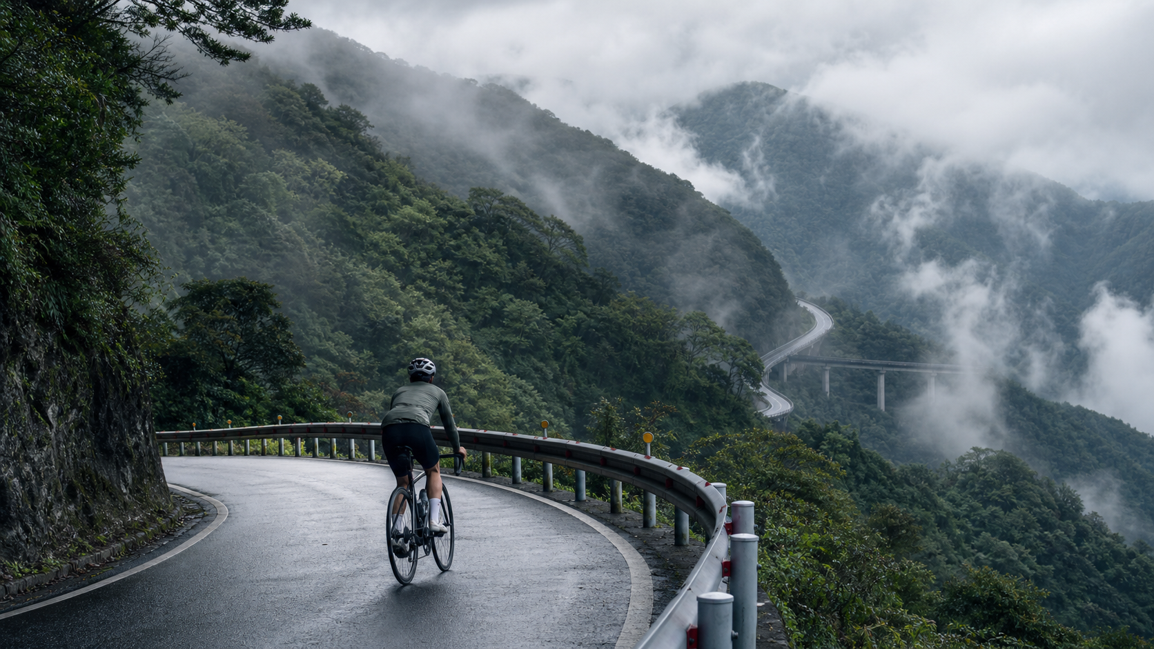
Deep in the Clouds: Riding the Northern Cross-Island Highway to Mingchi, a Century-Spanning Transversal Road
“If the mountain won’t turn, the road will; if the road won’t turn, the rider will.” No phrase fits the Northern Cross-Island Highway better. From Baling to Mingchi, a distance of just over nineteen kilometers, yet it carries more than half a century of road-building history, the mountain forest memories of generations of Atayal people, and the solitude and satisfaction of countless riders searching for their own rhythm in the mist.
The Birth of a Cross-Island Highway: From Pacification Trail to Tourist Route
To understand this stretch of the Northern Cross-Island Highway to Mingchi, we need to rewind the clock. The Northern Cross-Island Highway, officially designated Provincial Highway 7, is one of the few roads in Taiwan that runs directly from the western plains across the Xueshan Range to reach Yilan in the east. Its predecessor was actually a police patrol road built during the Japanese colonial era for the “pacification of indigenous peoples” policy—to control and monitor the Atayal tribes living in the Xueshan Range, the colonial government gradually widened and constructed existing mountain hunting trails and tribal connecting paths into a road system capable of transporting personnel and supplies.
This history may sound heavy, but precisely because of this background, the Northern Cross-Island Highway still preserves many place names and relics closely tied to Atayal history and culture. Take “Baling,” for instance—the name itself derives from the Atayal language, indicating that this area was once an important settlement and activity zone for the Atayal people. When riding past these place names, if you’re willing to stop and take a closer look at the road signs or read a few lines on the interpretive boards, you’ll realize you’re actually riding through a living historical corridor, not just a road for testing physical endurance.
After World War II, this road underwent multiple widening and improvement projects, gradually transforming from a mere police patrol road into a military strategic road and local connector, eventually evolving into the Northern Cross-Island Highway we know today—a transversal road combining transportation function with tourism value—after the rise of the tourism industry. The highway officially opened to traffic in 1966, becoming Taiwan’s second completed cross-island highway after the Central Cross-Island Highway, linking traffic between Dasi in Taoyuan and Yilan that previously required lengthy detours.
For modern road cyclists, every corner we climb with our pedals is layered with decades—even a century—of human history: the mountain trail memories of Atayal generations hunting, migrating, and living; the colonial shadow of the Japanese-era pacification roads; the sweat of countless road construction workers during postwar widening projects; and today’s endless stream of cyclists and self-drive tourists on this scenic highway. This stacking of multiple temporalities is precisely what makes riding the Northern Cross-Island Highway so captivating and worth savoring—you’re not just exercising; you’re traversing living history.
Baling Bridge: A Steel Verse Spanning the Dahan River
If you had to pick the most iconic landmark on the Northern Cross-Island Highway, the Baling Bridge would undoubtedly make the list. Completed in 2005, this steel bridge spans 220 meters in total length with a maximum span of 185 meters, making it the longest-spanning bridge along the entire Dahan River and one of the “Three Famous Bridges” of the Northern Cross-Island Highway (the other two typically refer to the older Baling No. 1 Bridge and Fuxing Bridge; for the exact scope and naming conventions, it’s best to consult the on-site interpretive signs and official sources).
From a rider’s perspective, the feeling of crossing the Baling Bridge is hard to fully capture in words. As you ride across the deck, deep river valleys flank both sides, the Dahan River winding through the canyon floor below, while layered mountain ridges stretch into the distance—on clear days, you can even see farther ridgelines glowing in layered shades of emerald green under the sunlight. This elevated, valley-spanning visual impact is a spatial experience that flatland riding simply cannot offer.
The engineering background of the Baling Bridge is also worth mentioning: it replaced an older bridge with a higher age and limited load capacity, significantly improving the Northern Cross-Island Highway’s traffic capability and safety. Whether you’re a bridge engineering enthusiast or simply someone interested in public infrastructure, standing at the bridgehead and gazing at this steel structure spanning the valley gives you a more intuitive appreciation of the engineering challenges involved in Taiwan’s mountain road construction—building a bridge with a span approaching 200 meters in such rugged terrain involves geological surveys, structural design, and construction logistics far more complex than one might imagine.
On one ride, I made a point of stopping at the Baling Bridge head, watching the river water shimmer below in the sunlight, and a thought crossed my mind: the fact that I can cross this road so effortlessly today is the result of decades of effort by generation after generation of engineers and road workers. This sense of gratitude toward the “road” itself is perhaps an insight that only comes after years of road cycling—we’re so accustomed to taking roads for granted that we rarely imagine how they came to be.
The Big Demon Section: Nine Bends, Eighteen Turns, and a Test of Will in the Mist
The stretch from Lala Mountain Visitor Center toward Mingchi Forest Recreation Area has earned a formidable nickname among the cycling community—the “Big Demon Section.” The name stems partly from the relentless gradient challenge and partly from the famous “Nine Bends, Eighteen Turns” sequence of continuous switchbacks along the way.
The term “Nine Bends, Eighteen Turns” can actually be heard on several mountain roads across Taiwan (the Toucheng end of the Northern Freeway, for instance, also has its famous nine bends and eighteen turns), referring to dense, consecutive hairpin and zigzag turns that force riders into a repetitive cycle of braking, cornering, and accelerating—a dual test of bike-handling skills and energy management. This stretch of the Northern Cross-Island Highway is equally known for its dense, unbroken succession of corners. Riding through it, you feel as though you’re trapped in an endlessly repeating loop—every corner you clear reveals another one ahead, with no end in sight. This visual and psychological fatigue often wears you down more than the gradient itself.
But it’s precisely on such stretches that you experience a peculiar state of flow. When you stop counting how many corners remain or how many kilometers are left, and instead focus on “turning this pedal stroke well” and “taking this corner well” in the present moment, your sense of time begins to warp—the stretch that felt endlessly grueling suddenly, at some point, reveals that you’ve already crossed most of it. This “flow” experience, common in endurance sports, is one of the most precious byproducts of long climbs. It leaves your body exhausted while your mind remains remarkably clear and focused.
As altitude gradually rises on the approach to Mingchi, the climate undergoes a noticeable shift. The air, which carried a hint of mugginess earlier in the ride, is gradually replaced by cool, moist mountain mist. This area sits right within the cloud belt elevation range, where moisture from the Pacific Ocean and northeast monsoon meets terrain uplift and frequently condenses into swirling fog, draping the entire road in a thin veil.
I’ll never forget the feeling of riding into this cloud belt for the first time: one moment it was clear blue skies with sunlight filtering through the trees casting dappled shadows, and the next, after rounding a corner, my view suddenly dissolved into a hazy white mist. Visibility plummeted, and the sounds around me seemed absorbed by the fog, leaving only the rhythm of my breathing and cadence. That instant scene shift felt like stumbling into another time and space—tinged with mystery, a touch of awe, and a measure of caution as I braced for the slippery road surface.
Mingchi Forest Recreation Area: A Mid-Route Pause Amidst Lake and Mountain Scenery
After conquering the notorious “boss-level” climb, arriving at Mingchi Forest Recreation Area brings a feeling of relief mixed with accomplishment—a shared memory for every cyclist who has ridden this stretch. Mingchi sits along the Northern Cross-Island Highway, near the border between Taoyuan and Yilan, at an elevation of roughly 1,000 meters. It is a well-known forest ecological park in the middle section of this trans-island highway.
Mingchi’s most iconic landmark is, naturally, the mirror-calm Mingchi Lake within the park. This alpine lake is surrounded by dense Japanese cedar forests and a variety of temperate vegetation. When the wind is still, the water reflects the surrounding mountains and sky, creating a scene so tranquil it almost feels unreal. For cyclists who have just endured a dual test of physical endurance and mental willpower, standing by the lake and gazing at the placid water and its reflections offers a sense of physical and mental release that no sports drink or energy gel can replicate.
The park is also home to several precious sacred trees (shenmu), bearing witness to the ecological depth this forest has accumulated over the years. These ancient giants are not only vital assets of the natural ecosystem—they also give riders a renewed perspective on the “scale of time” after a grueling climb. The nineteen kilometers of mountain road we huff and puff to conquer in an hour or two is, to these trees that have stood for centuries or even millennia, nothing more than an insignificant instant in their long lives. This contrast often instills in riders a deeper sense of humility toward nature and life.
The rich forest ecology of Mingchi Forest Recreation Area is also a tangible demonstration of the climatic transition in this region. From the subtropical broadleaf forests of Fuxing, Taoyuan, to the gradual transition into temperate coniferous and mixed broadleaf forests around Mingchi, this shift in vegetation zones with rising elevation is one of the most fascinating microcosms of Taiwan’s mountain ecology—you don’t need to fly abroad; simply riding nineteen kilometers and climbing over 800 meters on this highway lets you personally experience the transition from subtropical to temperate vegetation zones. Among road cycling routes worldwide, this is a relatively rare experience.
Of course, as a mature forest recreation area, practical details such as visitor facilities, opening hours, and ticket information at Mingchi are subject to change over time. Riders planning their trips are advised to refer to the latest official announcements from the park. If you plan to enter the park for a rest or a meal, it’s also wise to check the relevant regulations in advance to avoid arriving to find things unexpectedly closed.
Cilan and the Sacred Trees: Another Worthwhile Extension on the Northern Cross-Island Highway
If your energy and schedule allow, continuing from Mingchi toward Yilan will bring you past Cilan, another significant landmark. Cilan is adjacent to the renowned Cilan Sacred Tree Park, another area along the Northern Cross-Island Highway famous for its giant tree ecology. The park preserves numerous red cypress and Taiwan hinoki sacred trees, many of which are several hundred to over a thousand years old, making it one of the few regions in Taiwan that still maintains a large-scale primeval cypress forest.
Although Cilan lies beyond the core 19.45-kilometer section from Baling to Mingchi discussed in this article, for riders planning multi-day trips or seeking a more complete experience of the Northern Cross-Island Highway’s cultural and natural scenery, including Cilan as an extension will enrich the overall journey. The nineteen kilometers from Baling to Mingchi are a trial of physical endurance and willpower; the extended stretch from Mingchi to Cilan, by contrast, feels more like a slow, contemplative pilgrimage through nature, allowing riders to recalibrate their sense of distance from—and connection to—this mountain forest amid the rhythm of pedaling.
The sacred tree groves around Cilan also evoke a complex and thought-provoking chapter in Taiwan’s forestry development history. The fact that these ancient trees have survived to this day is tied to multiple policy shifts from the Japanese colonial era through the post-war period—a long transformation from timber-based economics to the rise of ecological conservation awareness. For riders who enjoy delving into local historical context during their rides, the Cilan Sacred Tree Park is well worth setting aside half a day or even a full day to explore at a leisurely pace.
The Four Seasons of the Cloud Forest Belt: When Is the Best Time to Ride the Mingchi Section
Because this stretch of the Northern Cross-Island Highway sits in a cloud belt and an elevation transition zone, it presents distinctly different faces across the four seasons. This is a major reason why many riders return to this route again and again—the same road, yet each season delivers a completely different visual and emotional experience.
Spring brings fresh greenery to the mountains, with roadside vegetation displaying remarkably vivid layers of green after being nourished by rain. Occasionally, you might catch the delightful sight of mountain cherry blossoms or other native flowering plants dotting the forest. The air in this season carries a distinctive fresh, post-rain aroma of vegetation, and riding through it feels as though the entire forest is breathing.
Summer, despite the oppressive heat of the lowlands, makes the Mingchi area a popular summer retreat thanks to its elevation and shade from the forest canopy. The dense Japanese cedar groves provide considerable shade even at midday, and mountain temperatures are naturally several degrees cooler than the plains. Riding into this forest in summer brings an instant sense of escape from the scorching heat.
Autumn is, in the minds of many veteran riders, the most beautiful season on the Northern Cross-Island Highway. While the fall foliage along the Mingchi section may be more scattered compared to famous maple-viewing spots like Aowanda, some broadleaf species along the way still display layered gradients of ochre and orange-red during the seasonal transition. This season also typically offers the most stable weather and the most dramatic cloud and mist formations—at dawn and dusk, you can often witness spectacular seas of clouds surging and flowing through the valleys. Many photography enthusiasts make a point of heading up in this season to capture such scenes.
Winter, shaped by the cold, damp northeast monsoon, frequently shrouds the area in drizzle and thick fog, giving the mountains a more serene, even slightly melancholic beauty. While riding comfort and safety are relatively lower in winter, for cyclists who prefer quieter seasons with fewer people and a more contemplative mood for experiencing the mountain atmosphere, the Mingchi section in winter has its own unique charm—just be sure to prepare thoroughly with proper warmth and safety measures.
Regardless of which season you visit, the signature cloud and mist scenery around Mingchi is a natural phenomenon you’re likely to encounter almost year-round. That moment of riding along the mountainside, watching mist slowly rise from the valley floor and gradually swallow the entire forest, is a unique sensation of awe and tranquility interwoven—something you can only truly grasp by standing (or riding) there in that very moment.
A First-Person Account: That Time I Found My Rhythm in the Clouds
At this point, allow me to share a personal riding experience from a more individual perspective—it was a clear morning, and I set out from Baling, ready to take on the legendary “boss-level” climb.
Before departing, I had done my homework: I’d studied the average gradient data, planned my refueling timeline, and confirmed my gear ratios. But the moment I pushed down on the first pedal stroke, facing that endless uphill road ahead, all the data and planning suddenly felt abstract and distant—what my body registered was only the gradually deepening fatigue in my legs, the rhythm of my heartbeat pounding against my eardrums, and the salty taste of sweat running down my cheeks.
Around the seventh or eighth kilometer, I began slipping into that classic “hitting the wall” mental state—time seemed to crawl, every corner revealed only another corner, with no end in sight. It was at that moment that I did something which, looking back, became the pivotal turning point of the entire ride: I switched off the display on my GPS cycling computer, stopped looking at the remaining distance, and focused only on my cadence and breathing rhythm.
Strangely enough, when I stopped obsessing over “how much farther,” I began noticing details along the roadside that I had previously overlooked—wild ginger flowers blooming in full glory beside a certain stretch, a suddenly expansive view at a particular bend, the layered blue-gray tones of distant mountain ridges, and even the subtle shift in the air as it gradually cooled and grew more humid. These details had all been selectively ignored in my pursuit of speed and efficiency, but when I slowed my mental pace, they surfaced one by one, becoming the most precious memories of that ride.
On the stretch approaching Mingchi, I rode into the clouds for the first time in earnest. It’s a feeling that’s hard to describe—one second I could clearly see the road a dozen meters ahead, the next my field of vision was filled with milky white mist, leaving only the blurred outline of the asphalt extending forward. I instinctively slowed my speed and my breathing, feeling as though I was being gently wrapped in the fog, with all the noise and anxiety of the outside world shut out in that moment.
When I arrived at Mingchi and saw that mirror-like lake before me, I stopped my bike and stood quietly for a long while. That intermingled feeling of exhaustion and fulfillment is an experience no language can fully convey—you know you’ve just conquered a solid challenge with your own legs, but the deeper sensation is something else: a connection, hard to articulate yet genuinely felt, with this mountain forest, with the history of this road, and with the countless people who have ridden here before.
This, perhaps, is the most precious gift that the Mingchi section of the Northern Cross-Island Highway offers to every rider willing to slow down and truly feel it—not just the sense of physical achievement, but an opportunity for dialogue with the land, with history, and with one’s own inner self.
What This Route Means to Riders: Why We Keep Coming Back
If you ask long-time riders of the Northern Cross-Island Highway (Beihang) why they are willing to repeatedly take on this route—which isn’t exactly the “best value for effort” (after all, the distance isn’t particularly long, nor is the climbing especially extreme)—the answers are rarely one-dimensional. Some ride it for training effect, treating it as a fixed benchmark segment for climbing practice; some are drawn to the unique scenery shrouded in clouds and mist, wanting to see its different faces each season; and others simply seek to rediscover those quiet moments of inner dialogue while riding.
The Mingchi section of the Northern Cross-Island Highway, in a way, acts like a mirror, reflecting each rider’s current state. When you ride this road feeling restless and agitated, the relentless succession of curves and gradients will wear your patience thin; when you ride it with a calm mind, you can instead find a nearly meditative focus and tranquility within those same gradients and curves. This difference in experience—varying by person and by state of mind—is precisely what makes this road so captivating and so intriguing.
Suggested Side Trips and Extending Your Journey
If time and energy permit, consider turning the Mingchi section ride into a more complete multi-day itinerary rather than simply “climb up and turn back.” The indigenous tribal culture around Baling, the peach and high-mountain produce farms of Lala Mountain (seasonal), the extensive trail system within Mingchi Forest Recreation Area itself, and the Cilan Giant Tree Park extending toward Yilan are all worthwhile extensions worth taking the time to explore in depth.
Details such as actual business information, opening hours, and event dates are subject to change over time and with operational conditions. We recommend obtaining the latest and most accurate information through official channels or on-site inquiries before planning your trip, to avoid outdated online information affecting your itinerary.
After finishing this ride, take a moment to sit down and quietly reflect on what this journey has brought you—it is not merely a record of a successful climbing challenge, but a unique journey woven together from Taiwan’s mountain forest history, Atayal cultural memories, and a dialogue with your own inner self. Mingchi on the Northern Cross-Island Highway deserves to be rediscovered time and time again.
Related Reading
- Riding into the Mist at Mingchi: An 18.5 km Journey from Baling into the Depths of the Cedar Forest
- The Mingchi–Baling Section of the Northern Cross-Island Highway: A Cloudy Forest Ride Beneath Lala Mountain
- The Southern Cross-Island Highway Westbound: From Meishankou to Tianchi, A Riding Memory of Resilience, Bunun Mountain Forests, and a Lake in the Clouds
- The Northern Cross-Island Highway (Provincial Highway 7): The High-Mountain Riding Challenge from Taoyuan to Yilan
#北橫 + #北進武嶺 最硬的員工旅遊 EP1 | #公路車 #拉拉山 | 明池 | 武嶺 | 武陵農場 | 雲海 | Taiwan Cycling Route Wulin
6 年前
台北闊瀨陡坡 騎旅 / 日本單車雜誌編輯車友臨時加入!/ 髮香才是最強的 / feat. 北迴歸線小隊 / 公路車 CT Yeh
6 個月前
大禹嶺 到 武嶺牌樓 全程前後實況錄影 | 北進武嶺 | 東進武嶺 | KOM | 訓練台 | 坡度分析 | Taiwan KOM Last 10 km HARD | 公路車
6 年前
觀霧 變好騎了! | 北高車友爆笑大會師 | 公路車 | 單車旅遊 Taiwan Cycling Route GuanWu
6 年前
大武山20%魔王陡坡【JJSC南台灣遊騎Day2】!屁股真的要裂開了...凡士林抹滿也沒用?神秘金教堂還有超便宜夜市
3 個月前
嘉義大埔、阿婆灣挑戰賽,美到以為在日本!ft. 環騎5 Cool 西拉雅188 / 公路車 / CT Yeh
7 個月前
一定要騎一次!阿里山最深處:里佳部落!單車旅行 | 2800m爬升 | 深度部落體驗:嗨翻晚會、螢火蟲、銀河 | feat. JJSC & 廢物伙伴 | 公路車 CT Yeh
9 個月前
新竹白蘭部落! 爬陡坡還能講笑話...? 廢物伙伴の約騎 | 公路車 | CT Yeh
4 年前