Riding from Changpi Lake to Jianqing: Rediscovering the Original Joy of Cycling in the Mist of Taiwan's Mount Fuji
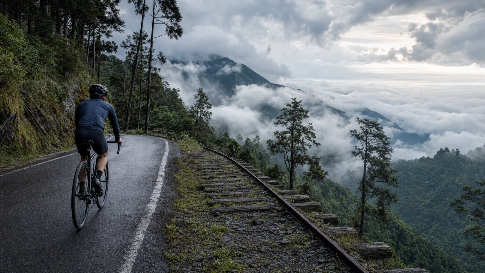
Riding from Changpi Lake to Jianqing: Finding the Original Joy of Cycling in the Mist of Taiwan’s Mount Fuji
The Beginning of a Legend: The Logging Era When Taipingshan Stood Alongside Alishan
If you ask any elder with some knowledge of Taiwan’s mountain development history, “Where was Taiwan’s most important logging ground?”, nine times out of ten you’ll hear two names mentioned together: Alishan and Taipingshan. In Taiwan’s modern development history, these two place names are almost synonymous—they aren’t just scenic areas, but rather epitomes of Taiwan’s entire forestry economy and mountain development technology. The route we’re riding this time starts at Changpi Lake and ends at the Jianqing high point, covering 14.18 kilometers with 973 meters of elevation gain—a journey deeply embedded in the historical fabric of the legendary Taipingshan logging grounds.
Taipingshan, located in Datong Township, Yilan, sits at an elevation of about 2,000 meters. During the Japanese colonial period, it was already an important forestry management zone, and together with Alishan and Basianshan, it was known as one of Taiwan’s three major logging grounds (some say one of the three major government-run logging grounds; the specific historical context and administrative evolution are quite rich, but here we’ll just take its spirit—Taipingshan’s status in Taiwan’s forestry history is indeed pivotal). In those days, to transport precious cypress and hinoki timber down from the deep mountains, the Japanese constructed an extremely sophisticated logging railway system across these rugged peaks, combined with aerial tramways, cableways, and other mechanical engineering, transforming what was once an inaccessible alpine forest into a vast industrial settlement.
The traces of this history remain deeply etched into Taipingshan’s landscape to this day. If you’ve ridden this route, you’ll notice that many place names and trail names along the way are connected to this logging railway history—the most representative being the Jianqing Historic Trail near the route’s endpoint at the Jianqing high point. This 0.9-kilometer trail was rebuilt from the roadbed of the old “Jianqing Line Logging Railway.” In other words, the ground you’re pedaling over today was, eighty years ago or even earlier, where tracks once carried massive cypress logs down the mountain. This sense of time overlapping with space is what makes this route most captivating and weighty—it isn’t just a climbing route; it’s a time tunnel through Taiwan’s forestry development history.
The Jianqing Historic Trail also carries a rather illustrious title: it was once selected by international media as one of the world’s 28 most beautiful trails. The reason behind this accolade is inseparable from its unique topography and views—the trail follows the former railway roadbed, with gentle grades and open vistas, offering panoramic views of mountain peaks and seas of clouds on clear days. The name “Jianqing” is said to derive from the meaning “clear after rain,” signifying that in the rain-prone Taipingshan region, encountering clear visibility is itself a precious stroke of fortune. This also adds a layer of metaphor to this cycling route—what you pursue through 973 meters of hard climbing is, in a sense, that moment of “Jianqing”: the reward of parting the clouds and mist to behold clear, unobstructed scenery.
Departure: The Serenity of Changpi Lake and the Trial Ahead
Changpi Lake is the starting point of this journey, located at the border area between Sanxing Township and Datong Township in Yilan. Compared to the main recreation area of Taipingshan, the atmosphere at Changpi Lake is noticeably more tranquil, closer to everyday rural scenery—the lake is calm, the surrounding forest lush, the kind of place that instinctively slows your breathing.
I remember arriving at Changpi Lake early that morning when the mist hadn’t fully lifted. A thin layer of moisture drifted over the lake’s surface, the silhouettes of distant mountains appeared and disappeared, and the entire scene was so quiet that the only sounds were me adjusting my cleats and buckling my helmet strap. This pre-departure stillness is actually a shared experience for all challengers of mountain routes—you know you’re facing 973 meters of climbing with an average grade of 6.9%, and that mix of anticipation and nervousness makes every preparatory movement feel especially focused.
The moment I clipped in and started riding, the gentle lakeside terrain quickly began to tilt upward. The Taipingshan road system, like all logging roads, has a typical personality—it doesn’t give you much room to warm up; the grade begins relentlessly from the very start. This kind of “straight-on duel” opening, in a way, matches the overall impression Taipingshan leaves on people: this has never been a place that treats you gently. Whether it was the loggers who once worked and lived here or the cyclists challenging it today, you must first demonstrate sufficient sincerity and preparation before you’re worthy of glimpsing the beauty within.
As elevation gradually increased, the open waterscape of Changpi Lake was quickly replaced by dense forest behind me. The road began to feature continuous hairpin turns—the inevitable engineering approach logging roads use to gain more elevation within limited horizontal distance. Riding on such roads, you clearly feel that this road was never designed for recreational cycling—it was planned so that carts loaded with precious timber could safely descend the mountain. The grades, the curve radii, everything serves the practical needs of timber transport rather than riding comfort. This “function over aesthetics” road character paradoxically creates a unique riding experience: during the climb, you feel not just physical fatigue but also a sense of respect for the laborers of the past—they had no gear systems, no carbon fiber frames, yet they relied on human strength and crude machinery to make a living in these mountains.
Scenery on the Climb: Wooden Architecture Imagery and That Illusion of “Japan’s High Mountains”
Taipingshan’s development history is deeply influenced by Japanese colonial-era forestry management, and this historical background isn’t just preserved in written records—it’s concretely reflected in the architectural planning and spatial atmosphere throughout the park. Many buildings and trail designs in the Taipingshan area carry a strong Japanese-style logging settlement character—wooden structures, clean lines, an aesthetic that blends seamlessly with the surrounding coniferous forest landscape—giving the entire park a unique hybrid temperament somewhere between Taiwan’s native mountain forests and a Japanese alpine resort.
This echoes a phrase in the route description: “very close to the texture of Japan’s Mount Fuji.” When I first read this description, I assumed it was exaggerated marketing language, but after actually riding this route, I understood what it truly meant to convey—it’s not saying you can actually see Mount Fuji itself here, but rather that the visual and psychological impression created by the overall atmosphere bears a curious resemblance to Japanese alpine logging resort areas. The image of clouds and mist swirling around conifer treetops, the occasional silhouette of wooden buildings, the conical mountain forms created by layered ridges visible from open viewpoints—these elements stacked together do evoke a certain essence of Japan’s alpine scenery, especially at moments when clouds surge like a sea and morning light slants through the forest. That sense of déjà vu, both familiar and tinged with exoticism, is a uniquely valuable experience of this route.
By the middle section of the route, the elevation had climbed to a height where my body could clearly feel the change in oxygen levels. Breathing became more labored than riding at sea level; even without increasing power output, my heart rate crept upward—the body’s way of telling you that you’ve entered a different world, a high-altitude realm ruled by clouds, conifers, and the silence of mountain winds. This physical challenge paradoxically forces your mental focus to sharpen. You find yourself unconsciously collapsing your attention onto each cadence, each breath in the present moment. External distractions have almost no room to exist during such intense climbing. This is also what many cyclists who love mountain riding often say: climbing is the most honest sport—it doesn’t give you the chance to be distracted by anything else; all your attention must be reserved for the grade ahead and your breathing.
Taipingshan National Forest Recreation Area is renowned for its rich landscape resources including seas of clouds, snow scenes, waterfalls, and lakes. The formation of these landscape resources, in a way, also shapes the season-limited charm of this cycling route. Visiting in different seasons, you’ll encounter a completely different Taipingshan—which is why many veteran cyclists say this route is worth riding several times a year, because the scenery you see in each season is almost an entirely different experience.
Jianqing Historic Trail: A Journey Through Time on a Logging Railway Roadbed
When you finally climb to the area near the route’s endpoint at the Jianqing high point, the sudden opening of the terrain before you brings a sense of release—“I finally made it.” This area is where the Jianqing Historic Trail is located. If your energy and time permit, I strongly recommend that after completing the cycling challenge, you park your bike temporarily, switch to walking, and personally traverse this 0.9-kilometer trail rebuilt from the roadbed of the old Jianqing Line logging railway.
Standing on the trail, you’ll realize that beneath your feet lies the former position of railway sleepers. The giant hinoki and red cypress trees on both sides still stand tall, telling of how much precious timber this forest once nurtured. When visibility is clear, the trail offers panoramic views of mountain peaks and seas of clouds. The openness contrasts sharply with the oppressive feeling of being surrounded by forest during the climb, and it’s no wonder this trail was selected by international media as one of the world’s 28 most beautiful trails—it isn’t just beautiful scenery; it carries a profound historical narrative. It’s the rare type of trail where “scenery and story carry equal weight.”
The name “Jianqing” derives from the meaning “clear after rain,” and the naming itself is full of poetry and philosophy. Taipingshan sits in the rain-prone mountain region of Yilan, where clouds, mist, and rainfall are the norm. Being able to encounter clear weather and see distinct mountain silhouettes in the distance is itself a blessing to be grateful for. This “hard-won clarity” is precisely the metaphor for this entire cycling challenge—through 973 meters of climbing, you’ll experience fatigue, doubt, and even thoughts of giving up, but when you finally stand at the Jianqing high point and watch the clouds part to reveal the mountains before you, that dual reward—visual and psychological—is a profound experience no flat ride can offer.
I’ll never forget that day when, nearing the finish, a gap suddenly appeared in the clouds that had been shrouding the mountaintop. Sunlight spilled diagonally across the treetops, dyeing the entire coniferous forest a nearly translucent emerald green. At that moment, I stopped pedaling, let my speed naturally slow, and simply watched that light drift through the trees. This kind of unannounced gift of beauty is the most enchanting aspect of mountain riding—you never know what the next turn will reveal, and it’s precisely this uncertainty that makes every high-mountain challenge filled with unique, unrepeatable memories.
What This Route Means to Riders: Not Just Conquest, But Dialogue
Many people ask me why I bother riding routes with nearly a thousand meters of climbing. Flat riding can also provide exercise and scenery—why put yourself through the suffering? I’ve thought about this question for a long time, and the answer I’ve arrived at is: the experience mountain routes offer is an entirely different level from flat riding. Flat riding is more of a process of enjoying scenery, while mountain routes—especially ones like Taipingshan with deep historical significance—are more like a dialogue with yourself and with the history of this land.
During the climb, you constantly confront the urge to give up. This urge may come from physical fatigue or from psychological doubt—“Can I really climb all 973 meters?” “Does this grade ever end?” Every time you choose to keep pedaling, you’re essentially conducting a small negotiation and persuasion with that voice inside you that wants to quit. This process, in a way, resonates across time with the challenges faced by the loggers who once worked in these Taipingshan forests—they had no modern equipment, no gear systems, yet they had to labor day after day in this terrain to make a living. When you ride this route built upon the history of the logging railway, a natural respect for the toil of those who came before seeps into your riding experience.
This is also why I believe the Taipingshan route shouldn’t merely be viewed as a challenge route with “impressive difficulty statistics.” Yes, 973 meters of climbing, 6.9% average grade, Category 5 classification—these numbers do attract riders seeking to challenge themselves. But if you approach this ride with only the mindset of “checking off a hard route,” you might miss what’s truly precious about it—the complete story, hidden within the clouds, the forest, the wooden buildings, and the Jianqing Historic Trail, of how this land was shaped by human labor and ingenuity.
Taipingshan by Season: Seas of Clouds, Autumn Colors, and Possible Snow
Taipingshan National Forest Recreation Area is known for its rich landscape resources including seas of clouds, snow scenes, waterfalls, and lakes. This also means the scenery on this cycling route takes on completely different faces depending on the season, and riders should choose their visit timing based on the experience they want.
Summer: The climate is relatively warm, making it the primary season for most riders to take on this route, but be mindful of the possibility of afternoon convective showers and the muggy sensation from high humidity in the mountains. Visiting on summer mornings offers a higher chance of encountering sea-of-clouds views, so it’s recommended to set off as early as possible.
Autumn: As temperatures gradually cool, the forests around Taipingshan begin to show patches of autumn colors or changing foliage. Although Taipingshan’s vegetation is primarily coniferous, the extent and scale of autumn colors depend on the year’s climate and specific forest areas, but autumn generally offers a higher probability of clear mountain weather, making it an excellent season for photography and enjoying distant views.
Winter: Taipingshan sits at about 2,000 meters elevation, and in winter temperatures occasionally drop to near freezing or even lower. In extreme conditions, some areas may experience snowfall or icing. While winter snow scenes are a dreamlike image of Taipingshan for many, for cycling challenges, winter is also the highest-risk season—icy roads are nearly an unacceptable risk for road bikes with narrow tires. Riders planning a winter challenge should definitely check official real-time weather and road condition announcements in advance. If there’s any concern about icing, prioritize safety and reschedule or cancel the trip.
Spring: The climate is relatively stable, with rainfall probability between winter and summer. Many veteran cyclists consider it the season with the best “value for money”—moderate temperatures, relatively less rain, and generally good visibility.
Regardless of which season you choose, remember that Taipingshan is a high-mountain terrain where weather changes far faster than you’d expect on flat ground. Checking the latest official announcements before departure is always the first step to safely challenging this route.
Suggested Add-ons: Extending the Cycling Challenge into a Complete Taipingshan Trip
If time and energy permit, extending this cycling challenge into a more complete Taipingshan trip is a highly recommended arrangement. Taipingshan National Forest Recreation Area itself is vast. Besides the Jianqing Historic Trail near the cycling route’s endpoint, the park contains multiple distinctive trails and attractions suitable for exploring on foot or at a leisurely pace after the cycling challenge.
Suggestion One: Plan a full-day itinerary; don’t treat it as just a cycling check-in task. Taipingshan deserves your time to savor slowly. If you rush through just to complete the route data, you’ll miss the truly moving details of this forest—the moment morning mist dissipates, the shifting light among the trees, the texture of century-old giants beside the trail. These all require slowing down to truly appreciate.
Suggestion Two: The starting area around Changpi Lake is also worth time to linger. Changpi Lake itself is a relatively tranquil spot. The combination of lake and mountain scenery works well as a warm-up before the cycling challenge or a soothing cooldown on the way back afterward, giving the entire journey a peaceful beginning and ending.
Suggestion Three: Pay attention to park entry regulations and time restrictions. Taipingshan National Forest Recreation Area is a controlled-access scenic area. Actual entry times, vehicle restrictions, and any related regulations may be adjusted per official policy. It’s strongly recommended to check the latest official announcements from Taipingshan National Forest Recreation Area before departure to ensure smooth trip planning.
Suggestion Four: Prepare ample warm layers and rain gear. As detailed in the climate section, even in summer, the low temperatures at the summit and possible rainfall should factor into your pre-trip preparations. A lightweight rain jacket or windbreaker is often the key item determining the comfort of this journey.
Suggestion Five: Approach this journey with a photographer’s and chronicler’s mindset. Taipingshan’s seas of clouds, forest textures, and wooden architecture imagery are all highly photogenic subjects. I recommend carrying a phone or camera to document this unforgettable journey blending physical challenge with cultural and historical depth. After all, routes with this combination of scenic depth and historical weight are rare in Taiwan’s cycling route landscape.
Conclusion: Looking Back from the Jianqing High Point, You’ve Ridden More Than 973 Meters
When you stand at the Jianqing high point and look back at the continuous hairpin turns spiraling up the road behind you, you’ll realize that this journey has given you far more than the achievement of “completing a Category 5 route.” What you’ve ridden is a road carrying a century of Taipingshan forestry development history; what you’ve pedaled over echoes, in a sense, the memory of the tracks that once carried precious cypress logs down the mountain beneath the Jianqing Historic Trail; the scenery you witnessed amid clouds and sunlight is a gift Taipingshan bestows, through its unique alpine climate, upon every rider willing to pay the price of 973 meters of sweat.
Taipingshan—this mountain range that stands alongside Alishan as a legend of Taiwan’s logging grounds—has its own way of allowing everyone who rides from Changpi Lake to the Jianqing high point to rediscover, among seas of clouds and forest treetops, the original, simplest joy of cycling: not to break records, not to show off elevation numbers on social media, but simply, through legs and pedals, to engage in an honest and profound dialogue with this land and its deep history. If you, too, are seeking such an experience, Taipingshan is worth the journey in person.
Related Reading
- Recommended Taiwan Mountain Trail Running Routes: Taipingshan, Xueshan, and Yushan Surroundings
- Taipingshan Cycling Challenge: A Forest Climb from Yilan to Taipingshan
- Ranking of Taiwan’s Ten Most Beautiful Cycling Climbing Routes
- Riding Where the Clouds Rise: Sea of Clouds, Sacred Springs, and Wushe Memories from Lushan Hot Spring to Provincial Highway 14
太平山單車員工旅遊 | 這樣玩CP值最高!| 公路車
5 年前
新竹羅平 x 天湖部落 大禹嶺級變態陡坡! 4K超高畫質 空拍 | 公路車
5 年前
一定要騎一次!阿里山最深處:里佳部落!單車旅行 | 2800m爬升 | 深度部落體驗:嗨翻晚會、螢火蟲、銀河 | feat. JJSC & 廢物伙伴 | 公路車 CT Yeh
10 個月前
里佳部落 阿里山單車深度旅遊! | 竹山/草嶺/來吉/奮起湖 | 無敵銀河絕景 全新路線探索! 驚險狀況百出! | 4K沉浸式畫質 | 公路車 | CT Yeh
3 年前
梅山36彎 奮起湖 單車挑戰 下集 #公路車
6 年前
梅山36彎 奮起湖 #公路車 之旅 2400m
6 年前
台灣登山王之路 KOM 全程參賽4K臨空錄影 PART1 穿越峽谷地形! #東進武嶺 太魯閣 / 燕子口 / 天祥 / 西寶 PART1 (公路車 / CT Yeh)
3 年前
大武山後門26%歡樂陡坡!JJSC南台灣單車行Day2 / 被颱風追著跑 / 公路車 / CT Yeh
2 年前