Between Gasping and Purple Butterflies: A Maolin Wugong Mountain Climb That Taught Me the Stories of the Land
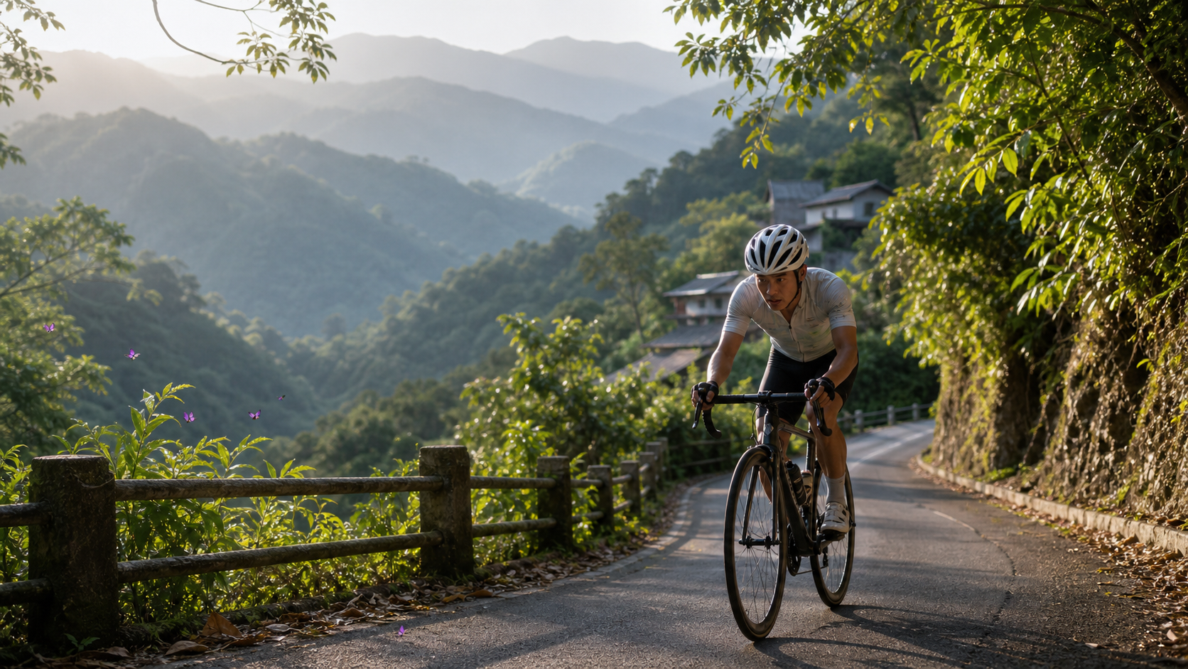
Some routes speak in numbers, others speak in gasps. The Wugong Mountain climb has both, but what truly made me remember this road are the things beyond those numbers.
A Road into Kaohsiung’s Only Indigenous Administrative District
If you unfold a map of Kaohsiung City’s administrative districts, you’ll notice that Maolin District holds a somewhat special position—it nestles in the southeastern corner of Kaohsiung, hugging the low-mountain belt at the southern end of the Central Mountain Range, and is the city’s only administrative district predominantly inhabited by Indigenous peoples. Its residents are mainly Rukai, with some Bunun settlements scattered throughout. This uniqueness in human geography gives Maolin a ceremonial sense of “entering another world” within the greater Kaohsiung cycling network.
Riding from the city center toward Maolin, you’ll clearly feel the rhythm of landscape transformation: suburban industrial roads gradually give way to mountain roads winding along river valleys, betel nut plantations and orchards on both sides are slowly replaced by more pristine secondary forests, and the humidity and temperature in the air shift as altitude rises. By the time you actually ride into Maolin’s main street, you’ll find that the scale of the streets, the architectural vocabulary, and the Indigenous language romanization displayed alongside Chinese on street signs all remind you that this is not just “another mountain”—it’s a place with its own cultural fabric and historical memory.
I would suggest that every rider preparing to take on the Wugong Mountain climb not treat this route merely as a training target for “grabbing a KOM or breaking a PR.” Of course, the previous guide article has already laid out the data aspects—gradient, elevation gain, gear ratios—very clearly. But if you only treat Maolin as a “place with steep slopes to train on,” you’ll miss what truly moves you about this road.
The Low-Mountain Character of the Southern Central Range
Maolin’s terrain has its own personality. Compared to the majestic grandeur of the Central Mountain Range’s main ridge, which frequently reaches two to three thousand meters, the low-mountain terrain around Maolin isn’t particularly high in elevation. Yet the slopes are steep, the valleys are deep, and the intensity of the terrain’s undulation is in no way inferior to high-altitude mountain areas—which, to some extent, explains why the Wugong Mountain climb can pack nearly a thousand meters of elevation gain into just 6.74 kilometers. Another characteristic of low-mountain terrain is its proximity to human settlements: villages, farmlands, industrial roads, and primary forests often interweave and coexist. This “wildness close to people” is a very unique experiential texture when riding in the Maolin mountains.
Wugong Mountain: A Place Name Treated with Caution
The place name “Wugong Mountain” carries a straightforward logic typical of mountain naming, likely related to how early local residents referred to the peak. However, regarding the exact origin of the name, its elevation, and the story behind its naming, there is currently no sufficiently credible specific material to cite. Rather than fabricating a plausible-sounding legend for the sake of making the article more “exciting,” I prefer to honestly tell readers: for the specific historical details of this matter, please defer to official place-name records or the oral accounts of local elders. This article will not invent any unverified storylines.
But even if the place-name lore is handled conservatively, the riding experience carried by the geographic coordinate of Wugong Mountain itself is still worth recording properly in words. When you’re gasping for air on a steep slope, your gaze sweeping across the forests on both sides, that feeling of “this mountain has its own name, its own story, and I just don’t fully know it yet” adds a layer of humility to the ride—you’re not conquering an abstract gradient number; you’re entering a specific, named place that belongs to someone.
The Season of Fluttering Purple Butterflies: Maolin’s Gentlest Side
If you ask anyone with even a passing familiarity with Taiwan’s ecotourism, “What is Maolin’s most famous natural landscape?”—nine times out of ten they’ll mention the Maolin Purple Butterfly Valley. This is one of Taiwan’s important overwintering butterfly valley ecological sites. Every winter (roughly spanning several months after the onset of winter; exact timing fluctuates slightly with that year’s climate, so it’s best to refer to the latest official observation period announcements), large numbers of purple milkweed butterflies gather in the valley to escape the cold, creating a magnificent spectacle of purple butterfly silhouettes dancing through the air. It’s practically Taiwan’s version of an ecological wonder, and its scale and fame are often compared internationally to the monarch butterfly overwintering valleys in Mexico.
The purple milkweed butterflies’ choice of Maolin as their overwintering habitat is no accident. The low-mountain valley terrain provides stable microclimatic conditions—the valley effectively blocks the strong northeastern monsoon while retaining a certain amount of sunlight and humidity, forming the warm sanctuary butterflies need to survive the winter. This ecological phenomenon, in a way, echoes the enduring character of the Maolin land itself: seemingly steep and rugged on the outside, yet harboring a gentle, sheltering strength within.
For riders, if you choose to take on the Wugong Mountain climb during the winter butterfly-viewing season, you’ll get a very special dual experience—your body endures the brutal test of gradients approaching 14 percent, yet in the periphery of your vision, you might catch a glimpse of purple milkweed butterflies fluttering across the forest. This contrast of “physical极限 challenge” and “nature’s serene wonder” occurring simultaneously on the same stretch of road is, in my private opinion, the most treasurable experiential layer of the Wugong Mountain climb—far surpassing any number on a KOM leaderboard.
One thing to note: the exact observation range of the butterfly season, the best viewing spots, and the scale of that year’s butterfly gatherings all vary from year to year due to climate and ecological changes. If your purpose is specifically butterfly viewing rather than pure climb training, I recommend checking the latest information released by the Maolin National Scenic Area Administration or relevant ecological conservation agencies before setting out, rather than planning your trip based solely on old impressions.
Rukai and Bunun: Wisdom of Living with the Land, Not Tourist Symbols
When it comes to Maolin’s cultural characteristics, I want to handle this part with particular care. The Rukai and Bunun peoples have lived on this land of Maolin for a very long time, and their relationship with the mountains and forests runs far deeper than the term “tourist material” can contain. The Rukai are traditionally known for their exquisite slate house architecture, the social hierarchy culture symbolized by the lily flower, and their craftsmanship aesthetics; the Bunun are renowned for the polyphonic choral tradition of “Pasibutbut” (eight-part harmony) and their rigorous hunting ethics. But the specific ways these cultural elements manifest, and the exact dates and content of rituals and ceremonies, vary by tribe and by year. I will not fabricate any specific ceremonial details or event times in this article. If you’re interested in gaining a deeper understanding of these cultural meanings, the most respectful and accurate approach is to visit tribal cultural centers in person, participate in officially open cultural tour activities, or directly consult the local tribes—rather than relying on secondhand retellings from internet articles.
What I’d rather emphasize is a more abstract but equally real realization: when you ride through an environment as steep and demanding as the Maolin mountains, you naturally develop a genuine respect for “the people who have lived, farmed, and traveled in this kind of terrain over the long term.” We ride the Wugong Mountain climb once, and even at full effort, it’s only a brief challenge of twenty or thirty minutes to an hour, after which we can return to flat ground for water and rest. But for the Indigenous peoples who have lived in these mountains for generations, this terrain is the real arena of their daily life—farming, hunting, and travel between tribes—a way of living refined together with their ancestors’ wisdom. This humility of understanding, I believe, is the mindset every outside visitor to an Indigenous administrative district should carry on the road—not treating local culture as background decoration along the ride, but recognizing that you are a brief passerby in the story of this land.
After Morakot: A Story of Resilience as a Road Is Ridden Again
To understand the land of Maolin, one cannot avoid Typhoon Morakot in 2009—the devastating “88 Flood Disaster” in Taiwanese memory. The astonishing rainfall brought by that typhoon severely damaged the mountain areas of Kaohsiung, including Maolin. Mudslides, river channel shifts, and collapsed and severed access roads caused severe destruction to many settlements and transportation lifelines built along the mountains. Some sections of road repair work took years of prolonged effort before gradually reopening to traffic.
For riders, this history should not be merely a lightly sketched background introduction. When you can ride your bike today, smoothly climbing along Maolin’s mountain roads all the way up to Wugong Mountain, this seemingly ordinary asphalt road actually carries a long story of resilience from destruction to reconstruction. The patched road surfaces you might notice along the way, the locally reinforced slope engineering, or the occasional check dams and river-training structures—all are concrete marks left by this history of rebuilding.
I’ve always felt that understanding a road’s “scars” makes the meaning of riding it more three-dimensional. The data tension of the Wugong Mountain climb—the official, mild-looking 9.7 percent versus the brutal truth of nearly 14 percent derived from actual measurement—in a way, also serves as a metaphor for the character of the Maolin land itself: calm on the surface, yet with far more violent geological and climatic forces at work within than one might imagine. And the people of this land, time and again, rebuilt their homes, repaired their roads, and continued their lives after each disaster. This resilience is far more worthy of a rider’s contemplation between pedal strokes than any gradient number on any climb.
First-Person Narrative: That Morning I Couldn’t Catch My Breath on Wugong Mountain
I remember it was a morning deliberately chosen to start early, avoiding the heat of summer. The first stretch of the ride from the city to Maolin still carried a morning chill, but once I entered the mountain area, the humidity rose noticeably and the air grew thick with the scent of vegetation. When I reached the starting point of the Wugong Mountain climb, the sky was just beginning to brighten, and a thin morning mist still lingered in the valley. The stillness was such that I almost forgot what kind of road conditions I was about to face.
The early section was indeed within acceptable range, as the guide had analyzed—my breathing rhythm could barely hold steady, and the gears still had room to spare. But after roughly a third of the way up, the gradient began to take turns so steep that I had absolutely no psychological preparation for them—that kind of slope where you instantly feel the whole bike might tip over backward made me immediately understand the true face of the vast chasm between “official 9.7 percent” and “actual feeling.” The only thing I could do at that moment was lower my center of gravity, grip the front of the handlebars tightly, use every ounce of strength to keep my cadence from dropping, while repeatedly telling myself in my mind, “save some reserve, save some reserve.”
What left the deepest impression on me was, on one short false flat where I could catch my breath, I caught a glimpse of what seemed to be a few butterflies fluttering through the forest by the roadside. It wasn’t the deep-winter butterfly season, and the numbers were nowhere near the spectacular scale of the Purple Butterfly Valley at its peak, but that instant where sight and gasping intersected gave me, in a state of extreme exhaustion, a rare feeling of something close to serenity. It wasn’t that “finally finished the climb” sense of accomplishment, but something more complex—my body enduring the torment of its limits, while my mind was simultaneously soothed by the natural scenery before me and the quiet strength of this land.
After completing the full climb, I found a spot near the summit to rest for a while. Looking back at the road I had just ridden up, I truly realized that the “steepness” of this route far exceeded anything I could have imagined from looking at data before setting out. The shock carried by physical memory is something no data analysis article can fully convey—you have to pedal it yourself to truly understand what the “gap between 9.7 percent and 14 percent” translates into as real pain in your legs and lungs.
Seasonal Scenery and Suggested Side Trips
If you’re planning to turn the Wugong Mountain climb challenge into a complete Maolin mini-trip rather than just rushing up and turning back, here are a few directions you can incorporate into your itinerary planning. However, for actual attraction opening hours, event content, and the latest transportation information, please defer to official announcements and on-site conditions:
- Visit during the winter butterfly-viewing season: As mentioned earlier, if your travel dates happen to fall within the purple milkweed butterflies’ overwintering season, I highly recommend including butterfly viewing in your itinerary. Seeing this important ecological wonder of Taiwan with your own eyes will leave a far deeper impression than just looking at photos or videos.
- Attractions around the Maolin National Scenic Area: The Maolin National Scenic Area also contains other natural and cultural attractions worth visiting along the way. For actual content and opening status, please check the official information from the Scenic Area Administration and arrange a combined itinerary that blends cycling challenges with ecological and cultural experiences.
- Local food and tribal cultural experiences: Maolin has some local food and crafts with Indigenous characteristics, but specific shop names, business hours, and activity details change quickly. I won’t make specific recommendations here. I suggest checking official tourism information channels upon arrival or asking local residents on site for more timely and accurate advice.
- Mind mountain traffic and return-trip planning: Some mountain road sections may be subject to traffic controls due to seasonal construction or weather factors. It’s advisable to build flexible time into your itinerary and stay alert to the latest road condition announcements.
In Closing: What a Road Taught Me
Looking back on my experience riding the Wugong Mountain climb, I find that what truly stays in my memory is never the “Category 4” classification label, nor the average power number displayed on the bike computer after finishing. What remains is that sense of humility when, gasping for air on a steep slope, I suddenly realized I was situated on a land carrying profound historical and cultural weight; it’s the solid feeling that this road—reopened only after years of repair following Typhoon Morakot—was now carrying my wheels forward; and it’s that instant, in extreme fatigue, of catching a glimpse of a butterfly’s silhouette, a gentle reminder that felt almost like a miracle.
Maolin—with its steep yet low-mountain terrain, the winter-limited serene wonder of the Purple Butterfly Valley, the generations-deep wisdom of the Rukai and Bunun peoples living alongside this land, and the unyielding story of reconstruction after Typhoon Morakot—has taught every rider who visits one thing: routes truly worth remembering are never just numerical combinations of gradient and distance, but the deeper, more worthy land stories that the road connects you to.
Why Such a Short Route Deserves to Be Ridden Again and Again
After completing a route, many riders file it under “done” on their checklist and rarely return to ride it again. But I believe the Wugong Mountain climb is the kind of route that deserves repeated returns—not only because its difficulty is enough to keep building your strength, but also because it presents a completely different face depending on the season, the time of day, and your state of mind when you visit.
The thin mist lingering on a dawn visit versus the humid, steaming heat under the midday sun are two entirely different physical experiences; the lush, dense green forest scenery of summer versus the serene wonder of winter when purple milkweed butterflies gather are also completely different visual memories. Even the same stretch of gradient feels vastly different in subjective pain when you ride it on a day when your fitness is good versus a day after a poor night’s sleep when your body is tired. This quality of “the same road, different every time” echoes, in a way, the dynamic resilience Maolin’s land has shown after disaster and reconstruction—it has never been a static, unchanging place, but an organic environment continuously adapting, repairing, and regenerating through the currents of time.
I’ve also come to realize that repeatedly returning to the same route is actually a deeper way of getting to know a place—far more meaningful than a one-time, hit-and-run check-in. The first time I rode the Wugong Mountain climb, I spent nearly all my attention coping with the gradient and my breathing, with no spare capacity to take in the surrounding scenery. But when I happened to visit again later, because my body already had a basic preparation and familiarity with the gradient, I could free up more mental energy to observe the changes in vegetation along the way, listen to the birdsong and insect sounds in the forest, and even more calmly notice the reconstruction stories told by the repair marks on the road surface. This “detail you only see after familiarity” is exactly why I want to encourage every reader not to treat the Wugong Mountain climb as a one-time challenge.
A Reminder for the Next Rider: Ride with Respect
If you’ve read this article and decided to challenge the Wugong Mountain climb yourself one day, the last reminder I want to give you isn’t about gear ratios or pacing—it’s about mindset. Maolin is Kaohsiung’s only Indigenous administrative district. This land carries the accumulated life wisdom and cultural memory of the Rukai and Bunun peoples across generations, as well as the arduous yet resilient reconstruction journey after Typhoon Morakot. When you ride past tribal settlements, past those repaired roads, past ecologically significant sites like the Purple Butterfly Valley, please carry the humility and respect befitting a visitor—slow down when passing through settlement sections, do not enter non-open areas at will, do not reduce the cultural elements you encounter along the way to novelty photo props, but rather treat this ride as an opportunity to sincerely get to know this land.
This shift in mindset won’t make your climb any easier—the gradient is still the gradient, and the 959.5 meters of elevation gain will still honestly test your legs and lungs. But it will give you, between pedal strokes, an added layer of awareness of “what kind of land, what kind of people’s living space, I am passing through.” And that awareness is often what truly stays in your memory from a ride and is worth savoring again and again.
Beyond the Ride: Maintaining a Long-Term Relationship with This Land
I’d also like to invite every reader to consider one thing—after you’ve conquered the Wugong Mountain climb, does your relationship with the land of Maolin simply end there? I don’t think it has to. Cycling can easily trap people in a “check-in style” mode of geographic consumption—ride, leave, take photos, depart—with little opportunity to truly get to know a place’s everyday face. But a place like Maolin, which combines ecological uniqueness with cultural depth, deserves to be approached by riders with a longer-term perspective.
Perhaps on your next visit, you don’t rush to challenge the climb, but instead arrange a purely ecological observation trip, taking time to experience the serenity of the Purple Butterfly Valley. Perhaps on the visit after that, you spend time learning more formal information about Rukai slate house architecture and Bunun musical traditions, through official channels or tribal cultural centers, getting to know these cultural meanings in a respectful and accurate way. Or perhaps, like me, you’re simply drawn back again and again by the sustained physical appeal of this route, returning to the starting point to re-measure with your legs the gap between the surface number of 9.7 percent and the true gradient of 14 percent.
Whichever way you choose to visit, I believe that as long as you carry an open and respectful mindset, the land of Maolin will respond to you in its own way—perhaps a steep slope that exhausts you yet fills you with accomplishment, perhaps a spectacle of purple butterflies dancing through the air, or perhaps just the brief tranquility brought by that quiet mountain forest in the morning mist. Added together, these experiences are the true, complete meaning of “having ridden the Wugong Mountain climb”—far beyond what any single data metric can define. If you’re ready, why not pick a morning and pedal this story yourself, with your own two feet.
Related Reading
- Wugong Mountain Climb Full Analysis: The 14% Truth Hidden Behind the Official 9.7% Gradient (Maolin, Kaohsiung)
- Riding the Maolin Mountains of Kaohsiung: 3 Indigenous Tribal Routes—Dona, Wutai, Ali
- Encountering Butterflies and Serenity on Lijia Forest Road: A Climb and Cultural Journey Through the Daba Liujiu Mountains
- A Stick of Incense at the End of the Mountain Trail: A Cycling Journal to Li Mountain Temple in Sanxia
台北闊瀨陡坡 騎旅 / 日本單車雜誌編輯車友臨時加入!/ 髮香才是最強的 / feat. 北迴歸線小隊 / 公路車 CT Yeh
6 個月前
大武山後門26%歡樂陡坡!JJSC南台灣單車行Day2 / 被颱風追著跑 / 公路車 / CT Yeh
2 年前
大武山20%魔王陡坡【JJSC南台灣遊騎Day2】!屁股真的要裂開了...凡士林抹滿也沒用?神秘金教堂還有超便宜夜市
3 個月前
#北橫 + #北進武嶺 最硬的員工旅遊 EP1 | #公路車 #拉拉山 | 明池 | 武嶺 | 武陵農場 | 雲海 | Taiwan Cycling Route Wulin
6 年前
那瑪夏x茶山 阿里山系深山單車行 Day2 累積爬升6000M | 🥶超陡連續下坡 整路看隊友刷 | 爬升一座西進武嶺 | JJSC | 公路車 | CT Yeh
3 年前
新竹白蘭部落! 爬陡坡還能講笑話...? 廢物伙伴の約騎 | 公路車 | CT Yeh
4 年前
藤枝二集團 單車行 Day1 | 南部小武嶺 | 爬坡爬到罵罵叫 | JJSC | 公路車 | CT Yeh
3 年前
爬坡ITT實境)台中 魔王 松鼠坡 首航 6:12 大肚山 大三元 科福路
8 年前