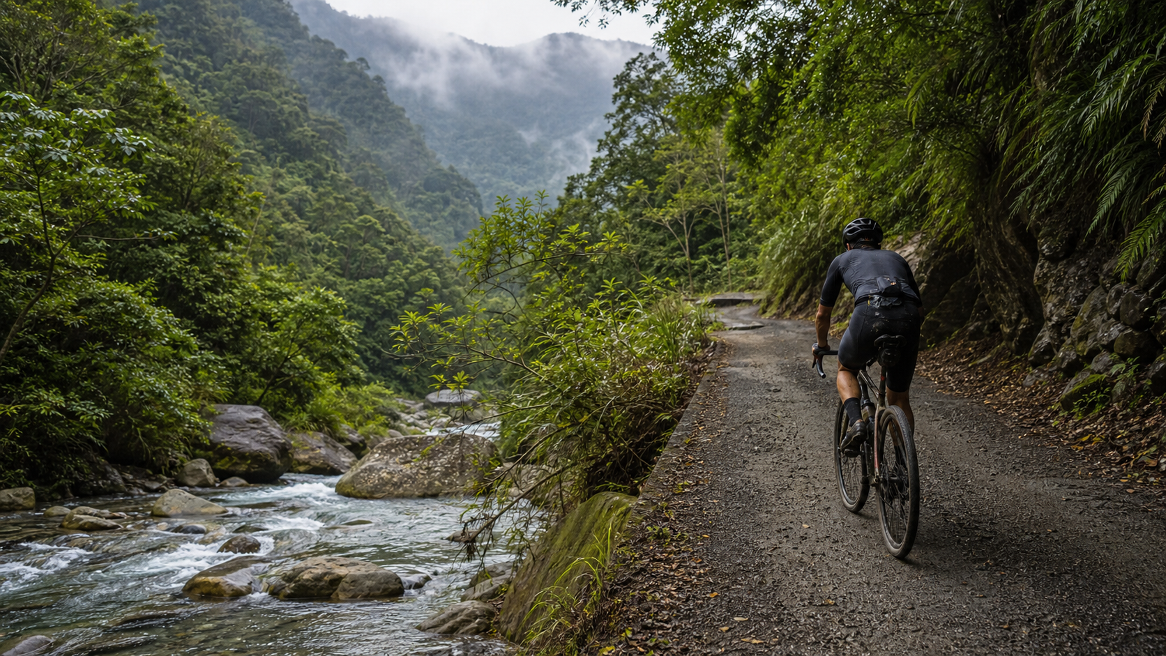
Climbing 12 Kilometers Upstream: Tonghou Forest Road and the Path Forged by the Atayal People
“Some roads are not planned into existence—they are slowly walked into being, generation after generation.”
Deep in the mountains of Wulai District, New Taipei City, there is an industrial road that winds upstream along the Tonghou River, stretching approximately 12.07 kilometers with a total elevation gain of 428.8 meters. It is called Tonghou Forest Road, and it serves as the western vehicular section of the Tonghou Cross-Ridge Historic Trail. The average gradient looks like a modest 1.8%—unremarkable on paper—but if you actually ride into it, climbing upstream all the way, you will discover that this road carries a weight far beyond what any set of numbers can express.
A Historic Trail Evolved from Hunting and Migration Routes
To understand Tonghou Forest Road, we must first return to an earlier historical context. According to historical records, the original form of the Tonghou Cross-Ridge Historic Trail was a path blazed by the Dakekan group of the Atayal people as they traveled north from the Xueshan Mountain Range for hunting and migration. For the early Atayal people, this was not a “scenic route” but a passage vital to survival—hunting, migration, and inter-tribal exchanges all depended on such a trail repeatedly trodden through the rugged mountains.
By the Guangxu era of the Qing Dynasty, with the establishment of anti-indigenous garrison outposts, the importance of this route grew further within the framework of official governance. During the Japanese colonial period, the Japanese government further widened and organized the original mountain path to support timber resource development and the administration of indigenous tribes, developing it into a more complete cross-ridge road. From a purely hunting trail to a cross-ridge route with administrative and economic functions, the history of the Tonghou Historic Trail is, in essence, a condensed history of Taiwan’s mountain development—from the survival wisdom of indigenous peoples, to the resource exploitation and governance tools of colonial rule, and finally evolving into the recreational route cherished today by hikers and cyclists alike.
The entire Tonghou Cross-Ridge Historic Trail spans approximately 30 kilometers, connecting Xiaoyi Village in Wulai District, New Taipei City, and Paolun Village in Jiaoxi Township, Yilan County. Walking the full length typically requires a full day or even a day and a half. The western section is the Tonghou Forest Road we discuss today, an industrial road passable by vehicles and bicycles; the eastern section transitions into a hiking route that climbs upstream, following the Tonghou River deeper into the mountains, passing through the saddle between Xiaojiaoxi Mountain and Hongludi Mountain (at an elevation of approximately 730 meters), crossing the Xueshan Mountain Range, and then descending along the Xiaojiaoxi River on the Yilan side. In a sense, this historic trail is like a time tunnel hidden within the forest, connecting Wulai and Jiaoxi—two places geographically distant from each other, yet once frequently traversed by the same group of mountain movers.
From a broader geographical perspective, the Xueshan Mountain Range is one of Taiwan’s five major mountain ranges, stretching across northern and central Taiwan and serving as the watershed for many major rivers. The saddle crossed by the Tonghou Cross-Ridge Historic Trail, while not particularly high in elevation (approximately 730 meters), is one of the key passages connecting two major geographic regions: the Lanyang Plain and the Taipei Basin. Before the advent of modern road systems, such cross-ridge routes played a critical role in regional transportation, the exchange of goods, and even inter-tribal marriages and conflicts. Today, as we ride our bicycles through the forest road with ease and leisure, it is difficult to fully comprehend the hardship and risk our ancestors endured when crossing these mountains on foot. But precisely because of this, every ride on Tonghou Forest Road feels like a humble tribute to history—we enjoy the fruits of roads opened by those before us, and we should hold greater understanding and respect for the long history this road carries.
The Tonghou River: The Skeleton of the Route Shaped by Flowing Water
The reason Tonghou Forest Road presents its distinctive terrain data of “low average gradient but high total elevation gain” lies in its inseparable relationship with the Tonghou River. This route was not deliberately planned as a straight climbing road; rather, it follows the river’s course, repeatedly hugging, crossing, and moving away from the banks of the Tonghou River, gradually stacking up to form the path we ride today. Centuries of erosion and scouring by the river have shaped the unique terrain texture of this valley, and humans—whether the Atayal ancestors, Japanese-era road builders, or later industrial road construction—could only adapt to such terrain conditions, opening passable routes according to the lay of the land.
As a result, riding on Tonghou Forest Road, you will constantly hear the babbling sound of the river accompanying you—sometimes the stream is just beside the road, crystal clear, its color shifting between shades of emerald green depending on the daylight and the depth of the riverbed; at other times the route moves slightly away from the riverbank, climbing over a short stretch of undulating terrain, and the river’s sound transforms from nearby clamor to a faint echo in the distance. This riding experience of alternating proximity to and distance from the river is precisely what makes Tonghou Forest Road most captivating and unique in its rhythm—it is not like a purely linear, one-directional road climb, but rather a prolonged conversation with a living, flowing river.
The water quality of the Tonghou River has long been renowned for its clarity, making it a private gem on the lists of many stream-trekking and water-play enthusiasts. Scattered across the riverbed are stones of various sizes, polished smooth and round by years of water erosion. During the summer months, you might occasionally spot people playing in the water to cool off. However, a word of caution: water levels and flow speeds in mountain streams can surge suddenly due to upstream rainfall. If you plan to play in the water or rest along the river sections, be sure to pay attention to weather conditions and official safety advisories, and do not recklessly wade into unfamiliar waters.
Riding along the forest road, you may occasionally catch glimpses of particularly wide gravel bars in the riverbed—places that are often the traces of flash floods or typhoon events that caused the river to change course or scour new channels. This dynamically changing landscape also reminds riders that the seemingly tranquil valley before them is actually in a constant state of natural transformation—the mountain forest has never been a static landscape painting, but a living system that still breathes and flows. This is also why every visit to Tonghou Forest Road, even along the same route, yields slightly different experiences depending on the season, water volume, and light—this quality of “never being quite the same each time” is precisely what makes mountain routes most precious and enchanting compared to standardized urban landscapes.
Scenery Along the Way: A Hidden Valley Deep in the Shade
Riding into Tonghou Forest Road, the first thing you notice is a marked change in air quality—leaving behind the hustle and bustle of downtown Wulai, with few vehicles around, you are instead surrounded by lush primary forest and the fresh, moist air of the mountains. As you venture deeper into the forest road, the mountain walls on both sides gradually close in, and the tree canopy forms a natural shaded corridor. Sunlight filters through gaps in the branches and leaves, casting dappled patterns of light and shadow on the road surface—this lighting effect is one of the reasons many photography enthusiasts make special trips to Tonghou Forest Road.
The vegetation along the way is richly layered, from the broadleaf forests common at lower elevations to the mid-elevation flora that gradually appears as altitude rises slightly, with considerable species diversity. If you are lucky, you might encounter Formosan macaques moving through the forest, hear the calls of various birds echoing back and forth, or even spot butterflies fluttering by the streamside—this is a route that still retains a fairly complete ecosystem, and for this reason, it especially requires riders to jointly maintain environmental cleanliness and practice a leave-no-trace ethic in the mountains.
Deep in the forest road, as elevation and terrain change, the valley gradually narrows and the mountain slopes become steeper and more rugged, giving you a genuine sense of “approaching the edge of the Xueshan Mountain Range.” Even though the section we ride only reaches the end of the forest road without entering the eastern section of the historic trail that requires hiking on foot, the mere 12 kilometers of climbing upstream is already enough to make one feel the layered, profound, and vast scale of Taiwan’s mountain wilderness.
Wulai: A Gateway Where Hot Springs, Indigenous Villages, and Mountains Intertwine
The Wulai District, where the Tonghou Forest Road begins, is itself a place full of stories. The name Wulai originates from the Atayal word “Ulay,” meaning “hot spring” or “dangerous creek” (so named because the local hot springs are accompanied by steam and scalding water). It is one of Taiwan’s most famous hot spring towns and an important Atayal settlement area in northern Taiwan. For a long time, Wulai has been renowned for its hot springs, cable car, waterfall scenery, and Atayal culture, making it a popular weekend destination for visitors seeking nature walks and relaxing soaks.
If you have time to spare after conquering the Tonghou Forest Road, consider strolling through Wulai Old Street to experience traditional Atayal food culture and craftsmanship, sampling local specialty snacks and mountain delicacies (for specific restaurant recommendations, please rely on on-site reviews and the latest information); the Wulai Waterfall and the Wulai Rail Cart are also classic itineraries for experiencing the area’s natural scenery and historical charm. The hot springs are, of course, the main event not to be missed—after a physically demanding forest road ride, soaking in a hot spring to soothe aching muscles is the perfect closing ritual, allowing both body and mind to fully unwind.
The rich Atayal cultural heritage of Wulai also adds a layer of human depth to the Tonghou Cross-Ridge Historic Trail route. When you ride along this ancient path trodden by Atayal ancestors, you are, in a sense, engaging in a dialogue across time and space with the historical memory of this land—the footprints of those who once hunted, migrated, and lived among these mountains have now been transformed into a recreational route that allows modern people to connect with the wilderness and train their bodies and minds. This transformation itself is worthy of our respect and understanding for this land and its cultural context, even as we ride.
In traditional Atayal culture, the relationship with the mountains has always been inseparable—hunting, gathering, and farming all depend on a profound understanding of and reverence for the mountain environment. This wisdom of “coexisting with nature” is reflected in many Atayal rituals and norms, such as the rotational use of specific hunting grounds and seasonal conservation concepts for certain flora and fauna, demonstrating a sustainability mindset far more rooted in daily practice than modern environmental slogans. When we ride our bicycles through these mountains today—once the living space of our ancestors—in the spirit of recreational sport, perhaps we too should adopt such an attitude: not merely treating the Tonghou Forest Road as a “check-in route” or a “mileage number,” but approaching it with understanding and respect, feeling the living memories and cultural depth that this land has carried and continues to sustain.
First-Person Riding Narrative: A Solitary Time Accompanied by the Sound of the Creek
That morning, I made a point of getting up early, departing from downtown Wulai, and riding toward the entrance of the Tonghou Forest Road while the sky was just beginning to lighten and before the crowds of tourists had arrived. The air still carried the lingering coolness of the night, mixed with the moist scent of the creek and vegetation. Taking a deep breath, I felt instantly awake.
Turning onto the forest road, the sound of traffic was gradually left far behind, replaced by the increasingly clear sound of flowing water. The early section had a gentle gradient, so I deliberately slowed down, letting my breathing and heart rate settle into a rhythm while fully savoring the tranquility of almost nothing but the wind, the creek, and the cadence of my pedaling—in the city, it’s rare to find such pure, undisturbed solitude.
Riding into the middle section, the terrain began to show noticeable undulations, and for a moment I wondered if I had taken a wrong turn—the average gradient I had looked up wasn’t that high, so why were there so many consecutive small climbs? I gradually came to understand that this is simply the inevitable character of the Tonghou Forest Road, which follows the creek’s topography. Every small ascent was accompanied by the gentle murmur of water flowing beneath or beside me. It was a strange sensation—my body gradually growing sore and fatigued from the continuous ups and downs, yet my ears and eyes were constantly nourished by the creek valley scenery and the babbling water, as if the fatigue was being neutralized by something lighter.
Midway through, I stopped at a creek-side spot with an open view, set down my water bottle, and sat on a large rock by the water to rest. The creek was so clear I could almost make out the texture of every pebble on the bottom, and sunlight filtering through the sparse canopy scattered dappled light across the water’s surface. At that moment, time seemed to slow down. I thought of how this path was once the trail trodden by Atayal ancestors while hunting and migrating, of the historical context of its widening during the Japanese colonial era for governance and logging, and of the countless hikers, cycling enthusiasts, and even earlier indigenous hunters who had left their own footprints and stories in this creek valley. And I, at this moment, was merely one traveler passing briefly along this long historical axis.
Continuing onward, as the elevation gradually rose, the forest canopy grew denser and the air became cooler. When I reached my turnaround point for the day, the distant mountains stacked layer upon layer, and I could already sense the more primal, more majestic geographical character of the Snow Mountain Range’s edge. I didn’t push on to tackle the hiking trail on the eastern section—that would require a more complete itinerary and physical preparation—but this 12-kilometer ride alone had already filled me with an indescribable sense of awe and closeness to these mountains.
On the return journey, every small climb I had conquered earlier now became an effortless, carefree descent. The creek continued to accompany me with its gentle murmur, but my mood had shifted from the anticipation and curiosity of departure to a contented calm. Back in downtown Wulai, I found a hot spring resort and sank into the warm waters, letting the muscles that had ached all morning fully relax. That feeling of body and mind being healed simultaneously was the perfect conclusion to this Tonghou Forest Road journey.
The Significance of Tonghou Forest Road for Riders: A Long-Distance Practice in Dialogue with Nature and History
Compared to the Linkou Dakeng Road mentioned earlier—a route that can be tackled on a whim and completed quickly as a daily training loop—the Tonghou Forest Road carries a meaning closer to a “ritualistic” long-distance practice. It requires more thorough trip planning, more adequate physical preparation, and more careful attention to weather and access restrictions—these “inconveniences” are, to some extent, part of its value. Because you must take the journey seriously to earn the scenery and the emotional payoff hidden deep in the creek valleys and beneath the forest canopy—rewards reserved for those who prepare with intention.
Riding along this ancient path trodden by Atayal ancestors, it’s hard not to reflect on the relationship between humans and nature, between humans and history. The very existence of this road is a condensed history of human-land interaction—from a hunting trail born of necessity, to a cross-ridge route serving as a tool of governance, to today’s recreational cycling route. Its function and meaning have continuously evolved with the times, yet the path itself, winding up along the Tonghou Creek, has faithfully recorded the long process of this land being trodden, used, and imbued with meaning.
For many riders who have long challenged the Tonghou Forest Road, this route is more like an annual or seasonal “pilgrimage”—not visited frequently, but every so often, they feel the urge to find a clear-weather day when their physical condition is good, to return to this creek valley and once again experience that unique sense of tranquility enveloped by the sound of water and forest shade.
I once heard a seasoned rider share that he schedules at least one Tonghou Forest Road trip every year—not to challenge his completion time, but simply to confirm that he still possesses the physical capacity and mental disposition to venture deep into the mountains and converse with nature. He described this trip as an “annual check-up”—not a physical health check, but a dual confirmation of his mental and physical state. If a particular year’s ride felt especially strenuous, he would take it as a warning signal, prompting him to readjust his life and training rhythm; if the ride felt relatively easy and relaxed, that solid sense of accomplishment would become important motivation to sustain his exercise habits. This approach of transforming a single route into a long-term tool for self-dialogue is perhaps one of the secrets behind why many serious cycling enthusiasts maintain their passion year after year—the route itself doesn’t change much, but the rider’s physical and mental state constantly evolves, and this road happens to provide a stable reference point for repeated comparison and confirmation.
Seasonal Scenery and Suggested Side Trips
The Tonghou Forest Road offers distinct scenery in each season. Spring is when the mountain’s vitality is at its peak, with fresh green leaves adorning the entire valley and creek water levels generally stable, making it suitable for longer exploration trips. Summer brings high temperatures, but the cooling effect of the forest shade and creek valley is noticeable, making it a preferred season for many riders—though afternoon thunderstorms and typhoon activity require extra attention, as mountain roads are prone to damage from heavy rainfall.
Autumn typically offers more stable weather and is one of the most comfortable seasons for riding, with gradually cooling temperatures that enhance the enjoyment of long-distance creek-side cycling. In winter, riders should be mindful of the wet and cold rainfall brought by the northeast monsoon and weather fronts, with an increased chance of mountain fog. It’s advisable to prepare for warmth and poor visibility, and it’s not recommended to challenge this route in cold, wet conditions unless necessary.
As for side trip suggestions, the Wulai hot springs are an excellent way to cap off a Tonghou Forest Road trip—after a long forest road ride, muscle soreness is inevitable, and soaking in a hot spring is one of the most natural and effective recovery methods. Additionally, the Atayal specialty foods on Wulai Old Street and the magnificent views of the Wulai Waterfall are worthwhile stops, adding greater cultural and recreational depth to a journey centered around cycling.
Conclusion: A Long Historical Scroll Written in Stream Water
Tonghou Forest Road is not just a 12.07-kilometer cycling route with 428.8 meters of elevation gain—it is a long historical scroll carved by stream water, recording the migration trails of the Atayal ancestors, the traces of Japanese colonial rule, and the new chapters that countless riders and hikers continue to write on this ancient path with their feet and wheels.
If what you crave is not merely a physical challenge but a profound journey that touches both body and mind, Tonghou Forest Road is an excellent choice worthy of careful planning and serious preparation. Remember to check the latest mountain access regulations and weather conditions in advance, set out with respect for this land and its history, and let the sound of the Tonghou Stream accompany you through this unforgettable journey upstream.
When you one day complete this ride and stand at the end of the forest road, looking back at the path you have traveled while listening to the Tonghou Stream still flowing gently beneath your feet, perhaps you too will suddenly understand, as I did, what kind of feelings drove those Atayal ancestors, those workers who carved the road during the Japanese era, and those travelers who journeyed between Wulai and Jiaoxi for generations—step by step through these mountains. What this road teaches us has never been merely how to pace ourselves or how to refuel, but how to approach a land bearing the memories of a long history with humility and reverence—perhaps that, in the end, is the true reason Tonghou Forest Road is worth returning to again and again.
Related Reading
- Tonghou Forest Road Practical Guide: The Real Terrain Behind 12.07 Kilometers and an Average 1.8% Gradient
- Riding Along the Nanshi River Toward a Cloudtop Tribe: The 14.4-Kilometer River Trail to Fushan
- Pedaling Into Atayal Hunting Grounds: Mountain Riding Memories of Luchang’s Steep Slopes and Shenxiangu Waterfall
- Shaoya Industrial Road: Riding Into the Paiwan Tribe Beyond Tupan Suspension Bridge, a Secluded Long Climb With Few Cars and Fewer People
藤枝二集團 單車行 Day1 | 南部小武嶺 | 爬坡爬到罵罵叫 | JJSC | 公路車 | CT Yeh
3 年前
一定要騎一次!阿里山最深處:里佳部落!單車旅行 | 2800m爬升 | 深度部落體驗:嗨翻晚會、螢火蟲、銀河 | feat. JJSC & 廢物伙伴 | 公路車 CT Yeh
9 個月前
嘉義大埔、阿婆灣挑戰賽,美到以為在日本!ft. 環騎5 Cool 西拉雅188 / 公路車 / CT Yeh
7 個月前
日本公路最高登山賽,台灣首位YT挑戰實錄,乘鞍登山賽40週年,賽前篇完整版,請到我的YT收看 #公路車 #cycling
10 個月前
台北闊瀨陡坡 騎旅 / 日本單車雜誌編輯車友臨時加入!/ 髮香才是最強的 / feat. 北迴歸線小隊 / 公路車 CT Yeh
6 個月前
台北大雁西飛 約騎挑戰 feat. Doris | 公路車 | CT Yeh
3 年前
#北橫 + #北進武嶺 最硬的員工旅遊 EP1 | #公路車 #拉拉山 | 明池 | 武嶺 | 武陵農場 | 雲海 | Taiwan Cycling Route Wulin
6 年前
小野田真的存在!日本赤城山爬坡公路賽 台灣首發團完全實錄 | 頭文字D真實賽道! | 看完東奧自行車賽後好想再去騎一次啊! | 公路車 | CT Yeh
4 年前